Let’s face it: diving in the high desert of Southeast Oregon gets a bad rap. It’s a long way from the closest SCUBA shop and compressor to this part of Oregon. Viz in the summer can be nil. There are only a few rocks and trout to look at underwater. The list of complaints goes on and on.
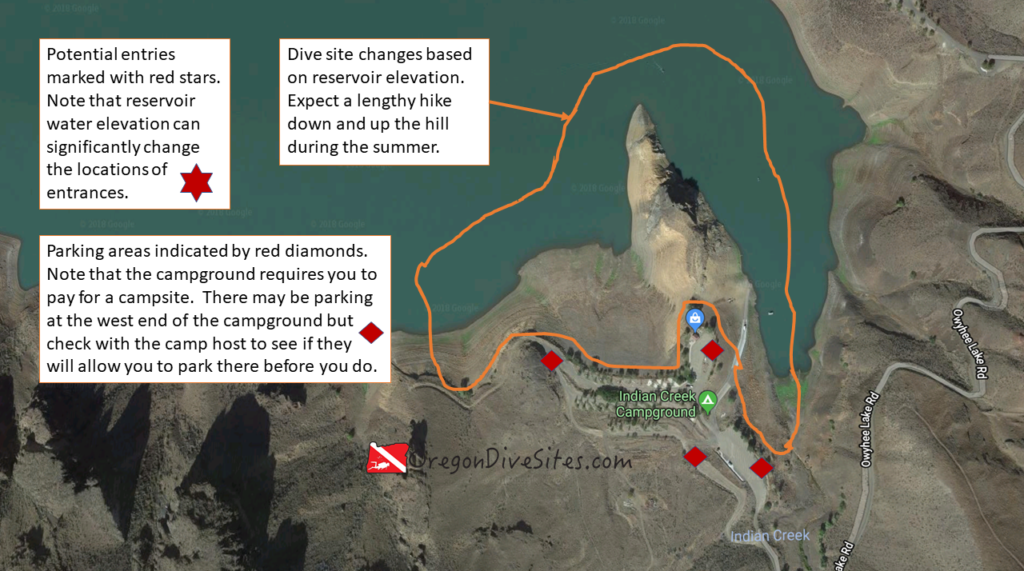
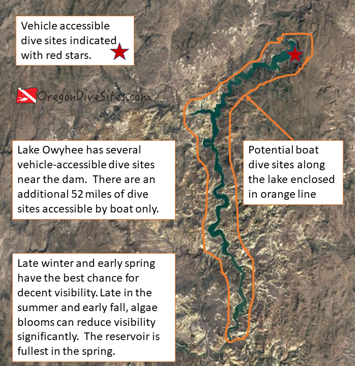
In spite of some of these shortcomings, Indian Creek Campground has some pretty awesome diving because of the island (usually a peninsula when the lake isn’t full) with its steep cliffs. This is probably the most fun dive site of the car-accessible shore diving sites along Lake Owyhee. If you get bored of doing these sites, there are 52 miles of dive sites along the lake that are accessible by boat. And as luck would have it, Indian Creek Campground has a boat ramp.
There are several other dive sites at Lake Owyhee worth mentioning including:
Lake Owyhee Reservoir: At 52 miles long, this reservoir has a huge number of dive sites for those with access to a good boat. The reservoir sits down in a canyon which makes for interesting wall dives.
Check with the campground hosts or the store and boat ramp operator before you park. During busy summer months, parking can be hard to come by.
Site Orientation:
The main attraction here is the island (peninsula during low water times) just north of the store. The island runs north-south. The east side has the more dramatic topography to dive but the whole thing is worth a look.
Entrances and Exits:
Watch for slick mud near the waterline when the water level has been falling. Check with the boat ramp attendant or in the store before using the boat ramp as an entrance. Watch for boat traffic — boaters aren’t used to seeing divers here.
Salt/Fresh:
This is a fresh water dive.
Shore/Boat:
This is a shore dive but can also be dived with a boat. A boat could be useful to get to the very northern tip of the island.
Normal Conditions:
There may be a few waves from boat wakes. Also currents can crop up when the dam is spilling a lot of water.
Normal Visibility:
At the height of summer, viz can be nil due to algae blooms. In the late winter and spring, viz can get up to 30 feet when cold, clean water flows into the reservoir.
Normal Temperature:
In the winter, temperatures can dip into the 30s. In late summer during low water years, temps can be in the 60s.
Best Time of Year:
Try diving here in the spring when the reservoir is the fullest and you have the best chance of good viz at Indian Creek Campground.
Max Depth:
You might find 100 feet in the middle of the channel if the lake is full.
Suggested Special Training:
This is an altitude dive site so be sure to have appropriate training.
Difficulty of Dive:
The dive is rated intermediate because of the altitude requirements. Also it can be easy to go far enough from your entrance that you might need a lengthy surface swim back.
Distance of Walk to Entrance:
If you can park by the store and the reservoir is full, you will only have to go a few feet. Otherwise, expect a few hundred feet to a thousand foot walk.
Surface Swim Length:
No surface swim is necessary although you might want to swim a few hundred feet north along the island.
Nearby Places to Camp and Diver-Friendly Hotels:
The campground here is a good place to base out of for a few days of exploring Lake Owyhee. There are a few other campgrounds in the neighborhood as well.
What Other People Have to Say About This Site:
Please write in the comments below your experiences with this dive site!
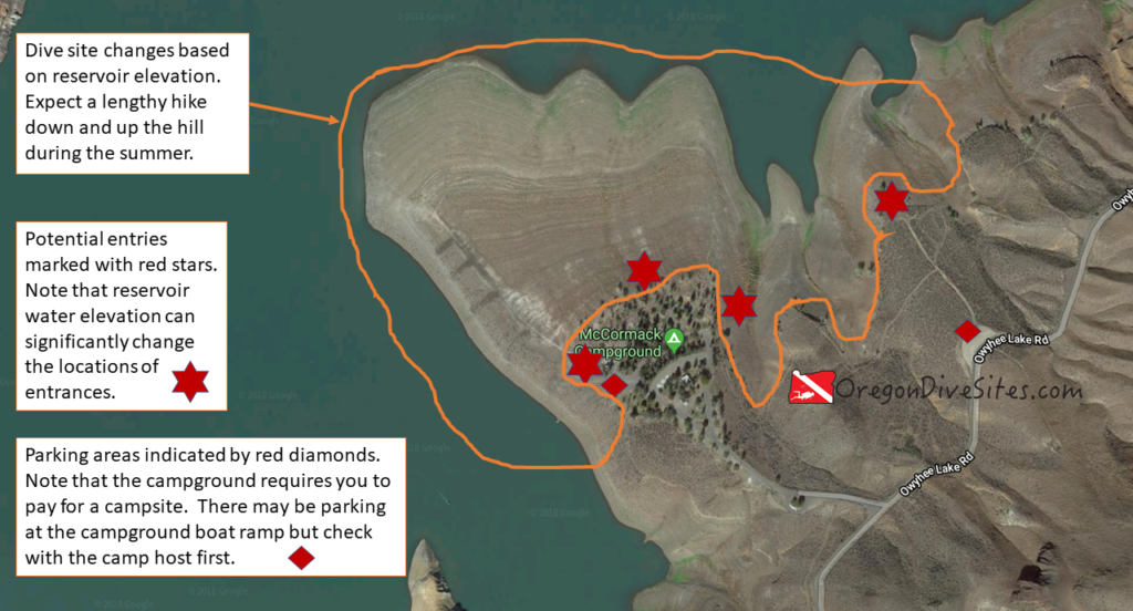
The McCormack Campground at Lake Owyhee is a good place to base for a few days of diving in this southeast Oregon high desert reservoir. This dive site doesn’t have that interesting of topography but it still is worth a look. You can launch a boat from here to explore the further reaches of the canyon as well.
There are several other dive sites in the immediate vicinity including:
Lake Owyhee Reservoir: At 52 miles long, this reservoir has a huge number of dive sites for those with access to a good boat. The reservoir sits down in a canyon which makes for interesting wall dives.
Before parking here, check with the camp host to see where they want you to park. They may have you park out by the main road if the campground is full.
Site Orientation:
The campground is on a peninsula that is surrounded on three sides by the lake. The steep submerged cliffs can be interesting to dive although there isn’t that much interesting topography close to shore.
Entrances and Exits:
The entrances/exits are simple walk-ins although they may be muddy and slippery near the water’s edge.
Salt/Fresh:
This is a fresh water dive.
Shore/Boat:
This is a shore dive.
Normal Conditions:
There may be a few waves from passing boats. Occasionally there can be some current when the dam is spilling a lot of water.
Normal Visibility:
In the late summer, visibility can be 3 inches due to algae blooms and stagnant water. In the late winter and spring when water flows are high, viz can be up to 30 feet.
Normal Temperature:
Depending on the time of year and how bad drought conditions are, temperatures might be in the mid 30s or the mid 60s.
Best Time of Year:
Spring has the best opportunity for good visibility.
Max Depth:
You might be able to find 100 feet of water when the reservoir is completely full.
Suggested Special Training:
This is an altitude dive site and requires the training to make sure you are within recreational scuba limits.
Difficulty of Dive:
We rate this an intermediate dive site because of the altitude.
Distance of Walk to Entrance:
Depending on where you park and how high the reservoir is, McCormack Campground might be only a few feet from the water or you might have to hike more than 1000 feet to reach the water’s edge.
Surface Swim Length:
No surface swim is necessary.
Nearby Places to Camp and Diver-Friendly Hotels:
The campground at McCormack Campground is a good choice. There are a couple other campgrounds in the immediate area as well.
What Other People Have to Say About This Site:
Please write in the comments below your experiences with this dive site!
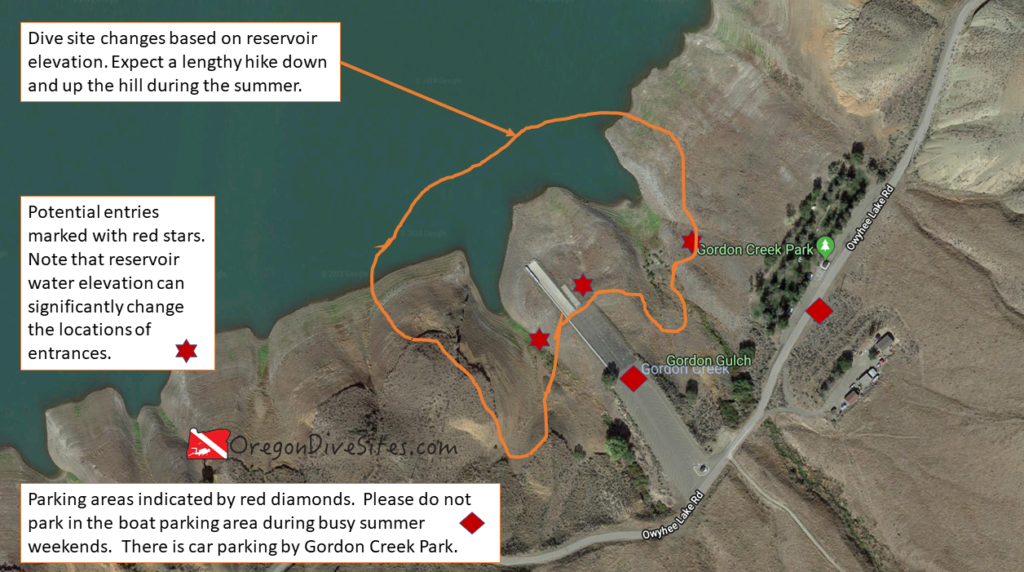
Gordon Creek Park and the Gordon Boat Ramp is a good place to check out Lake Owyhee with a nice shore dive. Southeast Oregon lakes aren’t that great for SCUBA diving but if you’re coming from Boise or want to do something different than a dive along the Oregon Coast, this dive site is a reasonable choice. The lake is high enough that altitude diving restrictions apply so do make sure to plan ahead.
When diving this site, be sure to steer clear of the boat ramp unless there isn’t any boat traffic. On busy summer weekends, boaters will not expect to see a SCUBA diver at Gordon Creek Park. It would be a very good idea to have a dive float flag to tow behind you.
There are several dive sites around Lake Owyhee including:
Lake Owyhee Reservoir: At 52 miles long, this reservoir has a huge number of dive sites for those with access to a good boat. The reservoir sits down in a canyon which makes for interesting wall dives.
There is car parking up by the road and the park. The parking along the boat ramp is meant for trucks with boat trailers. Talk to someone who works at the boat ramp or park before parking a car in a boat trailer spot.
Site Orientation:
The dive site unfolds along the southeast rim of the canyon. Head north to get to the deepest part of the lake. Head west or east to go along the canyon walls. Be sure to watch for boat traffic. Boaters won’t be expecting to see SCUBA divers at Gordon Creek Park.
Entrances and Exits:
Depending on the water levels in the reservoir, you may only have to walk a few feet to reach the water or it may be a significant slog to get down to the water. Watch for slick mud near the water line if the reservoir has been drawn down quickly in recent days.
Salt/Fresh:
This is a fresh water dive.
Shore/Boat:
This is a shore dive but you can also do a boat dive or launch a boat from here to do boat diving elsewhere in Lake Owyhee.
Normal Conditions:
There can be some waves from boat wakes but otherwise the only other potential underwater hazard is the current that can sometimes run along the very bottom of the lake.
Normal Visibility:
In the late winter and spring when the water flow rate into the lake is the highest, you will have the best chance of decent visibility. 30 feet is not unheard of here. During the late summer, algae blooms and stagnant water can make for 3 inches of viz.
Normal Temperature:
In the winter, water temperature can be near the freezing point. In the late summer in a drought year, water temps can get up into the 60s especially in the top 15 or so feet of water.
Best Time of Year:
You have the best chance of decent viz in the spring. There also is usually a little less boat traffic then.
Max Depth:
You might hit 110 feet at the absolute deepest part of the submerged canyon if the reservoir is completely full.
Suggested Special Training:
This is an altitude dive site. You will need to have altitude training to do this dive.
Difficulty of Dive:
We rate this an intermediate dive site because of the altitude dive requirement.
Distance of Walk to Entrance:
When the reservoir is full, you’ll only need to walk a few feet. If water levels are low, you might need to walk up to 1000 feet from the parking lot.
Surface Swim Length:
No surface swim is needed here. The submerged canyon walls are steep.
Nearby Places to Camp and Diver-Friendly Hotels:
There are several state park campgrounds in the immediate area that make for a good base to do some diving around the lake.
What Other People Have to Say About This Site:
Please write in the comments below your experiences with this dive site!
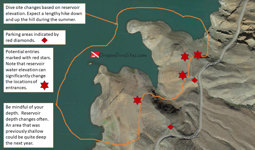
The two pullouts along Owyhee Lake Road south of the dam are a good place to get wet in Southeast Oregon. While lake diving isn’t amazing and the sometimes stagnant water of Owyhee Lake can have very low viz in summer, there aren’t many options in this part of the world to go SCUBA diving. The submerged canyon walls fall away from the shore quickly which makes for interesting topography to dive.
There can be a lot of boat traffic in the summer. Be sure to fly a dive flag. Boaters aren’t used to seeing divers in this lake.
This is one of a series of dive sites in Lake Owyhee. The other sites include:
Lake Owyhee Reservoir: At 52 miles long, this reservoir has a huge number of dive sites for those with access to a good boat. The reservoir sits down in a canyon which makes for interesting wall dives.
The pull-outs usually have a decent amount of parking except on popular, busy summer weekends.
Site Orientation:
The dive site unfolds along a couple thousand feet of the southeast canyon wall. There is a particularly interesting cliff along the finger of ridge that heads out from the southern parking area.
Entrances and Exits:
Depending on the height of the water in Lake Owyhee, entrances and exits might be easy or a scramble. It’s a good idea to walk the entrance before attempting it.
Salt/Fresh:
This is a fresh water dive.
Shore/Boat:
This is a shore dive although you can dive here with a boat, too.
Normal Conditions:
The only waves you’ll see are from passing boats. Be sure to have a good dive float.
Normal Visibility:
Depending on the time of year and how much water is flowing into the reservoir, viz could be 30 feet or 3 inches. In the late winter and spring, cold clean water flows into the lake and improves visibility. In the late summer, algae blooms can happen that causes viz to go practically to zero.
Normal Temperature:
In the winter and early spring, water temperatures can be in the mid 30s while in the late summer, water temperature can be 60 Fahrenheit.
Best Time of Year:
Spring is a good time to go diving here for better viz and for a fuller lake.
Max Depth:
You won’t go past about 110 feet here.
Suggested Special Training:
This is an altitude dive site.
Difficulty of Dive:
We rate this as an intermediate dive because of the potential for a long entrance hike and for the need of altitude training.
Distance of Walk to Entrance:
If the reservoir is full, a SCUBA diver might only need to walk 100 feet. Otherwise, it might be a 1000 foot hike down the canyon wall.
Surface Swim Length:
No surface swim is needed here.
Nearby Places to Camp and Diver-Friendly Hotels:
There are several state park campgrounds in this area of Owyhee Lake.
What Other People Have to Say About This Site:
Please write in the comments below your experiences with this dive site!
Lake Owyhee Reservoir is a 52 mile long lake in the high desert of Southeast Oregon where hundreds of potential dive sites have never been explored by divers. The canyon walls and valley make for interesting terrain to check out. This is an altitude dive due to the elevation of the reservoir. While diving in fresh water isn’t as interesting as all of the life in the ocean, Lake Owyhee is worthwhile to visit and dive if for no other reason than you may be the very first person to dive on a specific part of the lake. Very few divers ever make it to this part of Southeast Oregon.
In addition to the boat-accessible 52 mile reservoir, there are four sites that are accessible to car-based shore divers. They include:
This is an altitude dive. Please plan accordingly.
There is a lot of boat traffic on the lake especially in the summer. Because divers are so rare at this lake, boaters will not be looking for or expecting divers. It’s a very good idea to have a dive flag with you and be careful as you surface.
There are several parking areas at the boat ramps at Gordon Creek Boat Ramp, McCormack Campground, and Indian Creek Campground. The Owyhee Lake Road Pull-Outs do not have boat parking but there is car parking. Be sure to check with the campground and park hosts before parking to verify where they want you to park a car or a boat trailer.
Site Orientation:
With 52 miles of reservoir to cover, Lake Owyhee is a massive site that can’t be captured in one simple description. Our only advice is to be careful of unexpected currents, boat traffic, and stay away from the intake structures on the dam.
Entrances and Exits:
Depending on the water height behind the dam on Lake Owyhee, SCUBA divers may find water very close to the parking areas and lapping at the top of the boat ramps. On the other hand, during a drought year, the water might be 50 or even 75 feet below the top of the reservoir. In low water times, it can be quite the scramble to get down to the water.
Salt/Fresh:
This is a fresh water dive site.
Shore/Boat:
While there are a few shore diving sites, the vast bulk of this dive site is boat-only.
Normal Conditions:
The only waves you will see at this dive site come from boat traffic. There can be some unusual currents in certain areas so do be careful.
Normal Visibility:
Depending on the time of year and how much water is flowing into the reservoir, you might find 30 feet of viz or 3 inches of viz. SCUBA divers may find algae blooms in the summer and early fall. In the late winter and early spring, a large amount of cold, clean water flows into the lake and usually provides better visibility.
Normal Temperature:
In the late summer, temperatures can get up into the low 60s. In exceptionally low water years, it can get even warmer. In the winter and early spring when cold snow melt flows into the lake, the temperature may be down in the mid 30s.
Best Time of Year:
Spring has the best chance for both good viz and a full lake.
Max Depth:
Unless you bring a shovel, you shouldn’t be able to find any deeper spots than about 115 feet. As you move up the Lake Owyhee Reservoir, the bottom comes up to meet the surface of the water.
Suggested Special Training:
This dive site requires altitude diver training.
Difficulty of Dive:
We rate this as an intermediate dive site due to needing altitude diver training.
Distance of Walk to Entrance:
Depending on where you go diving and how full the reservoir is, you might only have a few feet to walk to the water or several thousand feet down a steep slope.
Surface Swim Length:
No surface swimming is needed. The submerged canyon walls are quite steep.
Nearby Places to Camp and Diver-Friendly Hotels:
There are several campgrounds around Lake Owyhee.
What Other People Have to Say About This Site:
Please write in the comments below your experiences with this dive site!
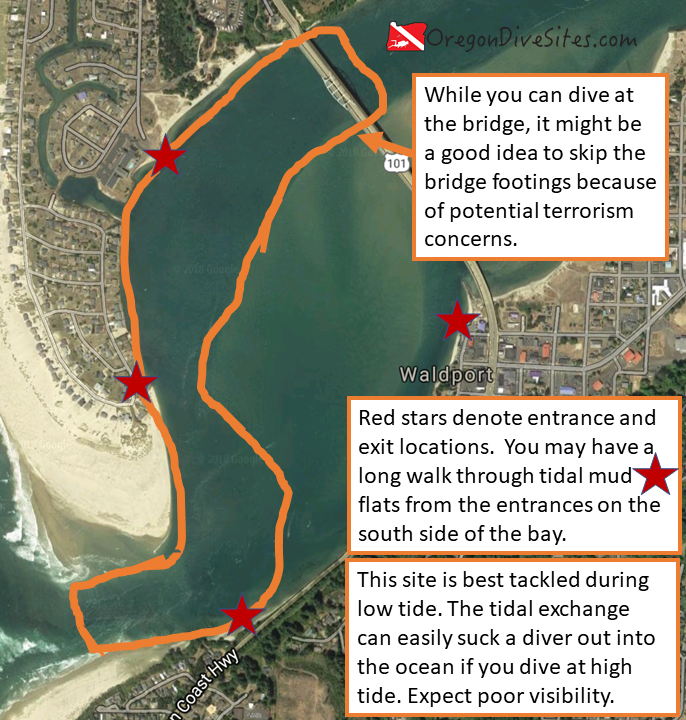
The Yaquina John Point dive site at Waldport is a good place to go if you want to do some crabbing while on SCUBA. It is not a good place to go if you are looking for decent visibility and benign conditions. This dive site is best tackled at low tide so that you will be sucked up into the bay rather than pushed out to sea. Be mindful to not bother the seals that sometimes haul out on the tidal flats.
There are four places that you can access the Yaquina John Point dive site in Waldport.
To get to the parking area near Alsi Resort, go west on Bayshore Drive north of the US 101 bridge. Bayshore Drive curves to the south. Follow it all the way until it dead ends next to the Alsi Resort and the gravel parking area by the water.
To get to the parking area in downtown Waldport, turn west on Spring Street just south of the US 101 bridge. The parking area is along Maple Street.
To get to the parking area south of Waldport, look for the small pull-out just as US101 heads south and leaves the bay.
To get to the drop off point at the southwest side of the dive site, go west on Bayshore Drive north of the US 101 bridge. Bayshore Drive curves to the south. Follow Bayshore Drive to turn west on Westward Ho Drive. Then turn south on Oceania Drive. Follow Oceania Drive all the way south until it curves around and starts heading north. The road becomes Alsea Bay Drive as it turns north. The drop off point is between the two houses on the east side of the road where you can see the bay and there are some small paths to the water.
Parking:
The three parking areas to access the Yaquina John Point dive site in Waldport surround the site. On the north side, there’s a gravel lot that, when we last checked, is free to park in next to the Alsi Resort. On the east side, there is parking in downtown Waldport. Be sure to check the signs — the last time we parked here, it was three hour parking. The south side has a small pull-out on US101 where one or two cars can fit. There is no parking at the southwest entrance/exit but this is a good place for a friend to drop you and your gear off.
Site Orientation:
The dive site is always changing because the Alsea River is not managed by the Army Corps of Engineers like the improved ports in Oregon. You want to dive in the channel where the water is deepest to hunt for crabs. A few years ago, there was a small channel near the south side of the bay but lately the main and deep channel hugs the north side of the bay. Between the main channel and downtown Waldport is a big tidal mud flat. You will have to slog across the expanse of mud to get to the water.
Entrances and Exits:
The entrances and exits on the south and east side of this dive site require long slogs across tidal mud flats. It’s not enjoyable but it is one way to get into the water. The entrance/exit for the pull-out area at the southeast side of the dive site is back up US101 where there is a small path down to the tidal mud flats.
On the north and west side, the entrances and exits are somewhat easier. You can walk down to the water along some small paths. Then it is a short trip across the tidal area to get into the channel.
Salt/Fresh:
This is a salt water dive.
Shore/Boat:
This is a shore dive. The water is usually too shallow to take a boat out to use as a dive platform.
Normal Conditions:
When diving at low tide, the dive will quickly become a drift dive as you get pushed up into the bay. It is a bad idea to dive this site at high tide because it is quite easy to get sucked out to sea if you aren’t paying close attention to your location. Unless you go out over the bar, waves and surf usually don’t penetrate into the bay. There can be some boat traffic going through the bay to do some crabbing or fishing. It’s a good idea to have a dive float that you tow behind you.
Normal Visibility:
Expect three to five feet on a very good day. You may find there to be zero viz on bad days. It’s par for the course at Waldport.
Normal Temperature:
48-52F is the typical temperature here.
Best Time of Year:
Winter and spring are good times to dive this site although any time of the year it’s possible to get in the water.
Max Depth:
Depending on what the channel is doing and recent storm activity, you might find water no deeper than 10 feet or water as deep as 35 feet where potholes form. The potholes are often where the crabs hang out.
Suggested Special Training:
It’s a good idea to have rescue diver training. This can be a difficult dive.
Difficulty of Dive:
We rate this an advanced dive because of the low viz and the likely drift nature of the dive. You don’t necessarily have to dive it as a drift dive but it’s easier.
Distance of Walk to Entrance:
The entrances on the south and east side can be up to 2000 feet from the water across the tidal mud flats. It’s not a very fun walk. On the north and west sides, the entrances are only about 50-100 feet from where your car will be.
Surface Swim Length:
No surface swim is necessary once you get into the channel.
Special Site Notes:
We highly recommend that you only dive this site at low tide. There is a significant risk of being sucked out to sea if you dive at high tide due to the tidal exchange. This is an exposed dive site at high tide because there is no jetty structure for you to grab onto or take refuge behind.
The slog across the tidal mud flats is a real challenge. Watch for holes in the sand where it is easy to fall.
This is a good site to do a drift dive where you ride the incoming tide up the bay.
Nearby Restaurants We Like:
There are a number of good restaurants both in Waldport and Bayshore.
Nearby Places to Camp and Diver-Friendly Hotels:
The Waldport KOA campground near the northwest entrance is a good place to base from if you plan to do multiple dives at this site. Otherwise, there are Siuslaw National Forest campgrounds up the Alsea River.
What Other People Have to Say About This Site:
Please write in the comments below your experiences with this dive site!
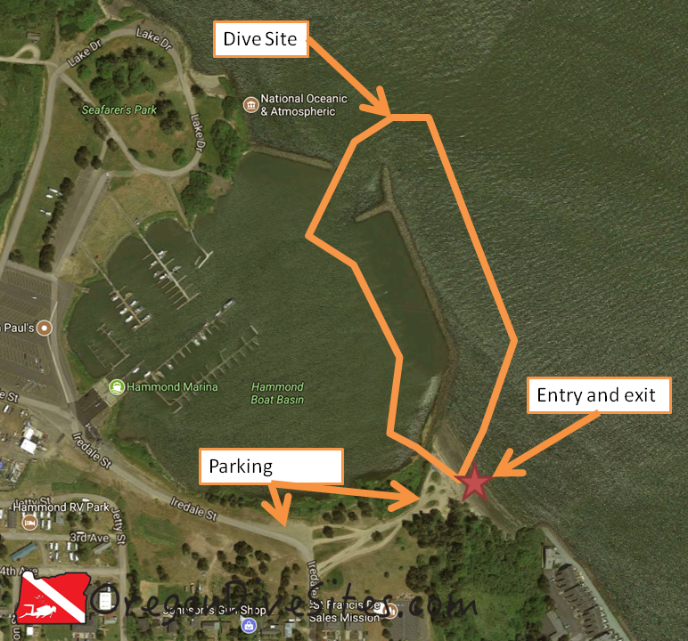
The south jetty at the Hammond Boat Basin is a good place to go diving if you’re in the general Astoria area and are interested in doing a little underwater hunting. There is decent crabbing and spear fishing here. The north and east sides of the jetty are exposed to the full force of the Columbia River where the current can really rip. While the water is shallow near the base of the jetty, head north and things suddenly get deeper as you approach the main shipping channel.
Head north on Iredale Street from downtown Hammond. Just past 5th Avenue there are some dirt tracks taking off to the right (east). These go down to the beach. Where Iredale Street turns west there is a pull-out.
Parking:
Most divers will probably park at the pull-out where Iredale Street turns west. Some people also park down on the beach by the entrance/exit.
Site Orientation:
The dive site at Hammond Boat Basin south jetty runs north-south along the jetty. If you stray too far north or east from the jetty, you’ll end up in the shipping lanes and in an area with a LOT of current.
Entrances and Exits:
The easiest entrance/exit is at the beach on the east side of the base of the Hammond Boat Basin south jetty. It’s a nice walk in and out. On the west side of the jetty, there aren’t many good places to get in and out but you can do it in a pinch.
Salt/Fresh:
Depending on the tidal flows, this is either a salt or a brackish dive.
Shore/Boat:
Hammond Boat Basin south jetty is a shore dive.
Normal Conditions:
You will likely encounter current on the east side of the jetty. The full force of the Columbia River roars through here. Occasional big waves come through the area that could cause some surge and surf as big ships pass.
Normal Visibility:
Depending on ocean conditions, river conditions, and the tide, you might get up to 10 feet of viz but usually it’s less.
Normal Temperature:
Expect between 45 and 55F water.
Best Time of Year:
Fall is a good time to check this dive site out although it’s accessible any time of the year.
Max Depth:
Along the jetty at high tide you will find 10-15 feet of water. If you head north or east away from the jetty, the shipping channel drops to 50 feet or more.
Suggested Special Training:
Advanced open water training is a good idea to dive the Hammond Boat Basin south jetty. Experience with diving in a high current area is also a good idea.
Difficulty of Dive:
We rate this as an intermediate dive because of the current and potential for low viz.
Distance of Walk to Entrance:
Depending on where you park, 20 to 300 feet of walking is in your future.
Surface Swim Length:
No surface swim is needed.
Special Site Notes:
Remember that the Columbia River has a roaring current during tide changes. Be prepared for that. Also viz can be very low here. Be mindful of fishermen on the jetty and stay out of their fishing lines.
Closest Local Dive Shops to Get Air Fills and SCUBA Gear:
Astoria has a full service SCUBA shop. We keep an updated list of dive shops and air fill stations at our Local Dive Shops page.
Nearby Restaurants We Like:
There are some good places to eat in Astoria. We like the fish and chips place that operates out of an old boat in downtown.
Nearby Places to Camp and Diver-Friendly Hotels:
There are many campgrounds in the general area that have yurts, tent sites, and RV sites. All are SCUBA diver friendly. We haven’t tried any of the hotels around here so please let us know if there is one in particular that you know to be diver-friendly!
What Other People Have to Say About This Site:
Please write in the comments below your experiences with this dive site!
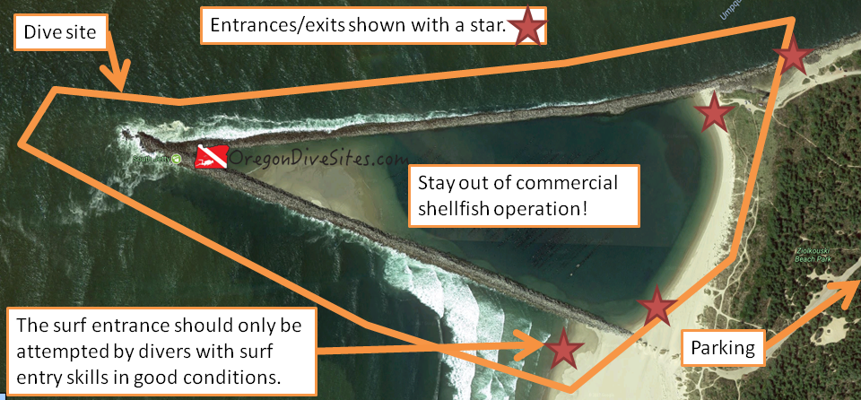
The Umpqua River South Jetty and the area known as the Triangle Jetty just outside the town of Winchester Bay on the (unsurprisingly named) Winchester Bay is a great place to explore a unique jetty structure. Nowhere else that we know of along the coast in Oregon can you find a triangle jetty with water that is almost always calm even when the see is violently rough. It is important to note that the shellfish being commercially grown are strictly off-limits to recreational divers. It is a crime to attempt to harvest any of the shellfish. Don’t give other recreational SCUBA divers a bad name!
We can’t confirm it with our own eyes but based on videos we’ve found on YouTube, such as this one, it appears there is some sort of wreckage to discover along the jetty. We suspect this could be a small boat or maybe a rail car that fell off the tracks when the jetties were originally constructed. One way or another, we now have the triangle jetty and the whole south jetty complex on the Umpqua River on our short list of places to revisit in the very near future. If you have more information on this wreck, including location and what it might be, please comment below!
Nearest Town:
The nearest town is Winchester Bay. A little further inland is Reedsport, Oregon.
From the town of Winchester Bay, take Salmon Harbor Drive south and west.
Parking:
There are several locations that you can park at depending on how crowded it is and where you want to enter/exit. On the south jetty (north side of the dive site), you can drive right out along the jetty. We think that you can also drive along the beach here to access the triangle jetty area where the commercial shellfish are grown. There even appears to be access down to the south side of the triangle jetty. However, before you drive out onto the sand, double-check the local OHV laws and make sure you have an OHV sticker on your vehicle.
If you don’t want to get into the sand, there are day use parking areas along Salmon Harbor Drive.
Site Orientation:
There are three distinct areas on this dive site. The first that most people are the most interested in is the inside of the triangle jetty. This is an active commercial shellfish business area. Stay well clear of the shellfish platforms and hanging shellfish lines. There is risk of entanglement in all of the equipment used by the commercial operation. There may also be discarded shellfish lines underwater that you could become tangled in.
The second area is along the south side of the triangle jetty all the way out to the jetty tip where the south jetty reaches the sea and then partway along the inside of the south jetty. This area is often rough. Sea conditions usually preclude people from SCUBA diving here. However, there is generally good spearfishing and crabbing in this area.
The third area is along the eastern part of the south jetty in the Umpqua River channel. This area is usually pretty decent to dive and has decent spearfishing and crabbbing.
Entrances and Exits:
There are a multitude of entrance and exit options at this site. You can crawl over jetty rocks on the south jetty to gain entrance to the Umpqua River channel. You can practice your surf entrances/exits along the outer south side of the triangle jetty. You can do an easy beach entrance into the interior of the triangle jetty. This site has it all.
Please note that the surf entrance/exit can be dangerous and should only be attempted by divers who have sufficient training and experience. Conditions can rapidly change and make this an untenable entrance/exit. Have a backup plan!
Salt/Fresh:
This is a salt water dive.
Shore/Boat:
This is a shore dive.
Normal Conditions:
If you are inside the triangle jetty area, there is almost never any bad condition to find. The area isn’t even really impacted by tidal changes. No real current, almost never any surf or surge, and extremely rarely are there any waves in here. People can dive this area just about any time of the day or night and any day of the year.
Along the southern outside area of the triangle jetty, past the tip of the south jetty, and into the mouth of the Umpqua River, you will likely encounter surf, surge, current, and waves. Watch conditions closely if you are going to dive this area. There are only a few days a year that parts of this area is accessible.
On the inside of the south jetty in the Umpqua River channel, conditions are often better than on the outside of the jetties. However, you need to be cognizant of the current. Dive with the tide. In really bad weather, you can have surf, surge, waves, and related nastiness. In a worst case scenario, scratch a dive here and instead go dive the inside of the triangle jetty.
Normal Visibility:
Depending on the time of year and recent storms, you can range from 40 feet of viz off the tip of the south jetty on down to less than 5 feet of visibility along the outer south side of the triangle jetty. Usually though you’ll find 20-25 feet of vis.
Normal Temperature:
Water temperature varies between 48 and 60F depending on the time of year. If there has been recent snow that is melting in the mountains that feeds the Umpqua River, the river channel can be a bit colder.
Best Time of Year:
The inside of the triangle jetty can be dived any time of the year even in bad sea conditions (use common sense though!). The south jetty along the Umpqua River is good most of the year although when the upwelling happens over the summer, visibility isn’t amazing. The southern outside part of the triangle jetty is a very finicky place to dive and usually only will be accessible a few days a year in the summer.
Max Depth:
Off the tip of the south jetty, you can find up to 50 feet of water at high tide and with optimal bottom conditions. When sand moves around, you won’t find it that deep. In the triangle jetty, you’ll find maybe 25 feet of water but usually shallower unless there has been dredging recently. On the south side of the triangle jetty, you might find 30 feet of water.
Suggested Special Training:
Inside the triangle jetty, open water divers with some experience at other dive sites should have a good time. In some of the rougher areas outside of the triangle jetty and on the south jetty, the diving can become very advanced and challenging. Specific training in surf entry/exit is needed if you plan to do that.
Difficulty of Dive:
We rate this as an intermediate dive although if you try to dive the jetty tip or the exposed portions of the triangle jetty, you can find yourself in extreme or impossible conditions. Inside the triangle jetty there are entanglement hazards and machinery hazards so pay attention!
Distance of Walk to Entrance:
Depending on where you park and where you’re walking to, you will either walk 50 feet or up to 1000 feet.
Surface Swim Length:
No surface swim is needed at any of the areas in this site.
Special Site Notes:
Remember that it is illegal to interfere with the commercial shellfish operation. We know those oysters look tempting but DON’T DO IT! You will give SCUBA divers a bad name!
Closest Local Dive Shops to Get Air Fills and SCUBA Gear:
As of the time of writing this, there are no dive shops or air fill stations along the Umpqua River near Winchester Bay. There is (or at least was the last time we checked) a shop in North Bend to the south. Otherwise you’re looking at heading inland to Eugene. Check out the updated list of local dive shops in Oregon to see where the closest shop is to your dive.
Nearby Restaurants We Like:
There are a couple good restaurants in Winchester Bay and further inland at Reedsport.
Nearby Places to Camp and Diver-Friendly Hotels:
There is a campground right next to this dive site and several others in the immediate vicinity. In Reedsport there are the normal hotels although we haven’t tried any of them so we can’t comment on if they are friendly to SCUBA divers or not.
What Other People Have to Say About This Site:
Please write in the comments below your experiences with this dive site!
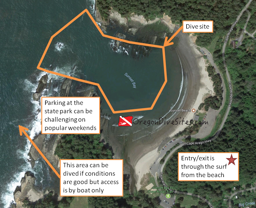
Sunset Bay and the associated beach is a great place to dive just south of Coos Bay on the southern Oregon coast. The bay provides good protection from rough Pacific Ocean conditions that are prevalent along the Oregon coast. The sandy beach is a good place to practice mellow surf entrances and associated skills. Parking and access can be a challenge on popular weekends when the beach is covered with families and the parking lot is completely full.
In spite of the summer crowds, this site can be a lot of fun to dive. Along the outer rims of the bay, rocks provide ample cover for marine life. For those with a boat or who are okay with a lengthy surface swim, you can reach the outer reaches of the bay. To the north there are several good dive sites and to the south the area along the shore can be dived in good ocean conditions. A kayak dive platform is handy to explore the further reaches of this dive site.
Nearest Town:
Charleston, Oregon is just up the road from Sunset Beach. Further up the highway is Coos Bay.
Follow the Cape Arago Highway south from Charleston. You can’t miss Sunset Bay. In the summer, traffic backups will let you know far in advance of reaching the bay.
Parking:
There are large lots maintained by the State parks department. The last time we were here, we think we remember paying to park although the situation might be different now. Double check that you are in a designated parking spot and make sure you have paid to park if it is required. The parking lots are heavily patrolled on the weekends.
Site Orientation:
The site is laid out in a convenient north-south-east-west configuration. The ocean is roughly west from the beach. The interesting rock formations and marine life are on the north and south sides of the bay. To return to the beach, head east.
Entrances and Exits:
This is a surf entrance/exit across a beach. Be sure to have appropriate training for the conditions you may encounter here. We haven’t seen a washtub effect at this beach but that doesn’t mean that it doesn’t exist. At the popular Monastery Beach down in Monterey, California, people routinely die within 20 feet of shore because they don’t know what they’re doing.
It is a good idea to decide which side of they bay you want to focus on. Park closest to that side and then enter from the beach in that general area. Pay attention to where the waves are breaking. The entrance/exit will be much easier if you can do so where there aren’t big waves breaking on the beach. Luckily it is rare for the entire beach to have breakers. It is rare for there to be much in the way of waves in general at this dive site but Sunset Bay can still produce them.
Salt/Fresh:
This is a salt water dive.
Shore/Boat:
This is a shore dive although for the outer reaches, you may want a boat or kayak dive platform.
Normal Conditions:
Usually conditions are pretty good here. You may encounter some waves and surf. Tidal exchange isn’t too strong usually. If you go outside of Sunset Bay, conditions get much rougher and many of the areas outside of the mouth of the bay are inaccessible to divers during rough sea states.
Normal Visibility:
The bottom is mostly sand and rocks. Depending on if the upwelling is occurring in the ocean and what the ocean is doing, you can have anywhere between 5 feet and 35 feet of viz here.
Normal Temperature:
Temperatures at depth are usually in the 45-55F range depending on time of year. On the surface near the beach, it can get up into the 60s in the summer.
Best Time of Year:
We like diving here in the fall, winter and spring. Sunset Bay during the summer is crammed with beachgoers which makes access difficult.
Max Depth:
We understand that at the mouth of the bay you can find up to 50 feet of water at high tide. We haven’t found it that deep but there’s a good chance that if you look around, you’ll find some deeper areas. Most of the site is in the 15-35 foot range.
Suggested Special Training:
You should have good surf entry/exit skills. While Sunset Bay is usually mellow, conditions can rapidly change. You don’t want to become a statistic.
Difficulty of Dive:
We rate this as an intermediate dive because of the surf entry/exit.
Distance of Walk to Entrance:
Depending on where you park, you could walk between 150 and 1000 feet. Park as close as you can to where you want to enter.
Surface Swim Length:
Kick out from the beach at least 500 feet to get into deeper water. Sunset Bay gets deeper the farther west you go.
Special Site Notes:
Surf entrances/exits are no joke. We know that many divers who were trained in the Willamette Valley didn’t receive hands-on surf entrance/exit training. It’s worthwhile having an instructor teach you how.
A lot of people frequent Sunset Bay. It’s a good idea to have a dive flag (we have one we use and love) and pay attention to what you’re doing.
Closest Local Dive Shops to Get Air Fills and SCUBA Gear:
Check our local dive shop page to find the most up to date information. As of the last time we edited this page, Port Orford and North Bend both have places you can get an air fill. North Bend’s shop should be full service. Otherwise you’re looking at heading inland to get gear serviced or a tank filled.
Nearby Restaurants We Like:
There is a fun place to eat right on the dock in Charleston.
Nearby Places to Camp and Diver-Friendly Hotels:
There are many state and federal campgrounds in the general vicinity. Some even have yurts. We haven’t tried any of the hotels around the Coos Bay vicinity so please let us know if you have a favorite that is SCUBA diver friendly.
What Other People Have to Say About This Site:
Please write in the comments below your experiences with this dive site!
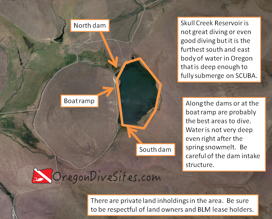
Skull Creek Reservoir is about halfway between and east of Andrew and Fields, Oregon. It holds the distinction as the (most likely… let us know if you know of a different place!) furthest south and east place in the state of Oregon where a SCUBA diver can go diving. Aside from that distinction, there is not much reason to haul SCUBA gear out to southeast Oregon south of Steens Mountain and east of the Alvord Desert. The best time of year to go dive here is in the spring just after the spring snow melt.
It should be noted that this reservoir is on private land owned by Roaring Springs Ranch. Be sure to call the ranch manager and ask for permission before you go out here. You don’t want to make the long drive only to find gates closed. You don’t want to start your dive only to have a ranch hand to ask you to leave.
Call the Roaring Springs Ranch for special directions to Skull Creek Reservoir. There are a lot of different roads out in the sagebrush and it’s easy to get lost out here.
Parking:
The folks at Roaring Springs Ranch will tell you where to park at Skull Creek Reservoir to be out of the way of ranch operations.
Site Orientation:
The two dams on the north and south sides of Skull Creek Reservoir are probably the best places for you to try diving. There is a small boat ramp near the north dam that might make it a little easier of a dive.
Entrances and Exits:
You can pretty much walk in anywhere along the road although it is a steep hill.
Salt/Fresh:
This is a fresh water dive.
Shore/Boat:
This is a shore dive.
Normal Conditions:
When there is water in the reservoir, it is usually pretty calm. However, high winds in the area can cause some small whitecaps.
Normal Visibility:
This is a high altitude reservoir in the high desert. Expect very murky water with zero visibility a very real possibility.
Normal Temperature:
If there is still snow on the ground, water temperature won’t be much above freezing. Toward the end of the summer, expect more like 55-60F at the upper part of the (rather small) water column.
Best Time of Year:
Spring is when you will find water the deepest and clearest. Call the Roaring Springs Ranch well in advance before you want to go dive here.
Max Depth:
You’ll probably find about 25 feet of water.
Suggested Special Training:
This site is at about 5000 feet. Be sure that you have altitude diver training.
Difficulty of Dive:
We rate this as an intermediate dive because of the altitude component. Also remember this is a very remote dive site. You aren’t getting any help out here if you have an accident.
Distance of Walk to Entrance:
Unless Roaring Springs Ranch asks you to park elsewhere, you should be able to park very close to the water’s edge.
Surface Swim Length:
You might want to kick out 100-200 feet to get deep enough water so that you can submerge.
Special Site Notes:
This reservoir is on private land owned by Roaring Springs Ranch. Get permission well in advance of your visit to Skull Creek Reservoir. Remember that this is an altitude dive site.
Closest Local Dive Shops to Get Air Fills and SCUBA Gear:
The closest place you can get gear serviced or an air fill is up in Boise or out in Bend.
Nearby Restaurants We Like:
There is no food anywhere in the area. Bring your own.
Nearby Places to Camp and Diver-Friendly Hotels:
There is plenty of BLM land out here where you can camp.
What Other People Have to Say About This Site:
Please write in the comments below your experiences with this dive site!