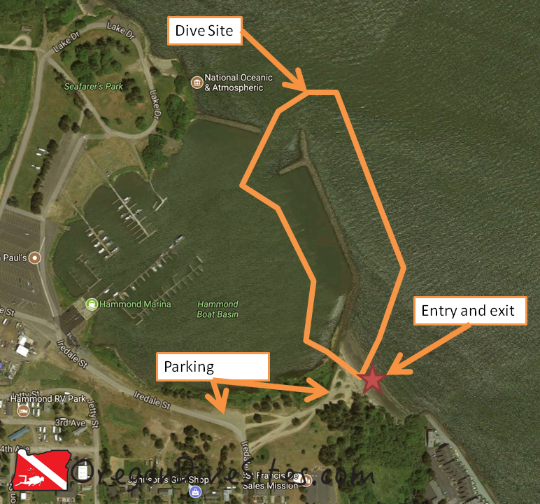
The south jetty at the Hammond Boat Basin is a good place to go diving if you’re in the general Astoria area and are interested in doing a little underwater hunting. There is decent crabbing and spear fishing here. The north and east sides of the jetty are exposed to the full force of the Columbia River where the current can really rip. While the water is shallow near the base of the jetty, head north and things suddenly get deeper as you approach the main shipping channel.
Head north on Iredale Street from downtown Hammond. Just past 5th Avenue there are some dirt tracks taking off to the right (east). These go down to the beach. Where Iredale Street turns west there is a pull-out.
Parking:
Most divers will probably park at the pull-out where Iredale Street turns west. Some people also park down on the beach by the entrance/exit.
Site Orientation:
The dive site at Hammond Boat Basin south jetty runs north-south along the jetty. If you stray too far north or east from the jetty, you’ll end up in the shipping lanes and in an area with a LOT of current.
Entrances and Exits:
The easiest entrance/exit is at the beach on the east side of the base of the Hammond Boat Basin south jetty. It’s a nice walk in and out. On the west side of the jetty, there aren’t many good places to get in and out but you can do it in a pinch.
Salt/Fresh:
Depending on the tidal flows, this is either a salt or a brackish dive.
Shore/Boat:
Hammond Boat Basin south jetty is a shore dive.
Normal Conditions:
You will likely encounter current on the east side of the jetty. The full force of the Columbia River roars through here. Occasional big waves come through the area that could cause some surge and surf as big ships pass.
Normal Visibility:
Depending on ocean conditions, river conditions, and the tide, you might get up to 10 feet of viz but usually it’s less.
Normal Temperature:
Expect between 45 and 55F water.
Best Time of Year:
Fall is a good time to check this dive site out although it’s accessible any time of the year.
Max Depth:
Along the jetty at high tide you will find 10-15 feet of water. If you head north or east away from the jetty, the shipping channel drops to 50 feet or more.
Suggested Special Training:
Advanced open water training is a good idea to dive the Hammond Boat Basin south jetty. Experience with diving in a high current area is also a good idea.
Difficulty of Dive:
We rate this as an intermediate dive because of the current and potential for low viz.
Distance of Walk to Entrance:
Depending on where you park, 20 to 300 feet of walking is in your future.
Surface Swim Length:
No surface swim is needed.
Special Site Notes:
Remember that the Columbia River has a roaring current during tide changes. Be prepared for that. Also viz can be very low here. Be mindful of fishermen on the jetty and stay out of their fishing lines.
Closest Local Dive Shops to Get Air Fills and SCUBA Gear:
Astoria has a full service SCUBA shop. We keep an updated list of dive shops and air fill stations at our Local Dive Shops page.
Nearby Restaurants We Like:
There are some good places to eat in Astoria. We like the fish and chips place that operates out of an old boat in downtown.
Nearby Places to Camp and Diver-Friendly Hotels:
There are many campgrounds in the general area that have yurts, tent sites, and RV sites. All are SCUBA diver friendly. We haven’t tried any of the hotels around here so please let us know if there is one in particular that you know to be diver-friendly!
What Other People Have to Say About This Site:
Please write in the comments below your experiences with this dive site!
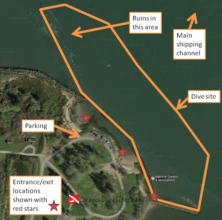
The Hammond Boat Basin North Jetty is exposed to the ripping current of the Columbia River main channel but if you dive at slack tide, you can get halfway decent water conditions and a unique experience. Old ruins on the north end of the dive site usually have good marine life although there is the potential for entanglement hazards. Head away from land a few feet and you will find the water gets rapidly deeper as you approach the shipping channel.
Head north from downtown Hammond toward the boat basin. Follow signs for Seafarer’s Park.
Parking:
There is parking at the north end of Seafarer’s Park. The last time we checked, parking was free although this could change. Be sure to verify with the signs in the park.
Site Orientation:
The dive site sticks along the jetty from the entrance to Hammond Boat Basin at the south and east end of the dive site up to the ruins at the north and west side of the dive site. If you head north and east, you will eventually run into the Columbia River shipping channel. It’s a good idea to stick closer to land where you have at least a little protection from the current.
Entrances and Exits:
There are several decent entrances and exits along the jetty near the parking area. We marked several on the map above but if you look around a little at the Hammond Boat Basin North Jetty, you will find a few other decent places to climb over the jetty rocks and enter the water.
Salt/Fresh:
This is a salt water dive.
Shore/Boat:
This is a shore dive.
Normal Conditions:
There can be a lot of current at this site. Be sure to dive at slack tide. SCUBA diving here during the tidal exchange could cause you to have a rather unpleasant drift dive. There is regular boat traffic in the area both in the main shipping channel and coming into and out of the Hammond Boat Basin. It’s a good idea to fly a dive flag.
Normal Visibility:
Depending on river conditions, you might get only 3 feet of viz or up to 15 feet of viz. Be prepared for low visibility conditions.
Normal Temperature:
Temperatures can vary between 45 and 55F depending on the time of year.
Best Time of Year:
There doesn’t seem to be one best time of year here. In the summer the parking lot can be full on the weekends.
Max Depth:
You can find 50+ feet of water if you head toward the main shipping channel. Right along the jetty, the water is shallow (max 15 feet).
Suggested Special Training:
Advanced open water training is a good idea to dive the Hammond Boat Basin North Jetty. Experience with diving in a high current area is also a good idea.
Difficulty of Dive:
We rate this as an intermediate dive because of the current and the risk of entanglement in the old ruins on the north end of the dive site.
Distance of Walk to Entrance:
Depending on where you enter, you might need to walk up to 200 feet. At the entrances near the parking lot, you may need to wade through water before it gets deep enough to swim in.
Surface Swim Length:
No surface swim is needed here.
Closest Local Dive Shops to Get Air Fills and SCUBA Gear:
The dive shop in Astoria is full service and has an air fill station.
Nearby Restaurants We Like:
There is decent food in Hammond and great food over in Astoria.
Nearby Places to Camp and Diver-Friendly Hotels:
There are a lot of public campgrounds in the area with good camping. We haven’t tried any of the local hotels so please let us know if you’ve found one that is SCUBA diver friendly.
What Other People Have to Say About This Site:
Please write in the comments below your experiences with this dive site!
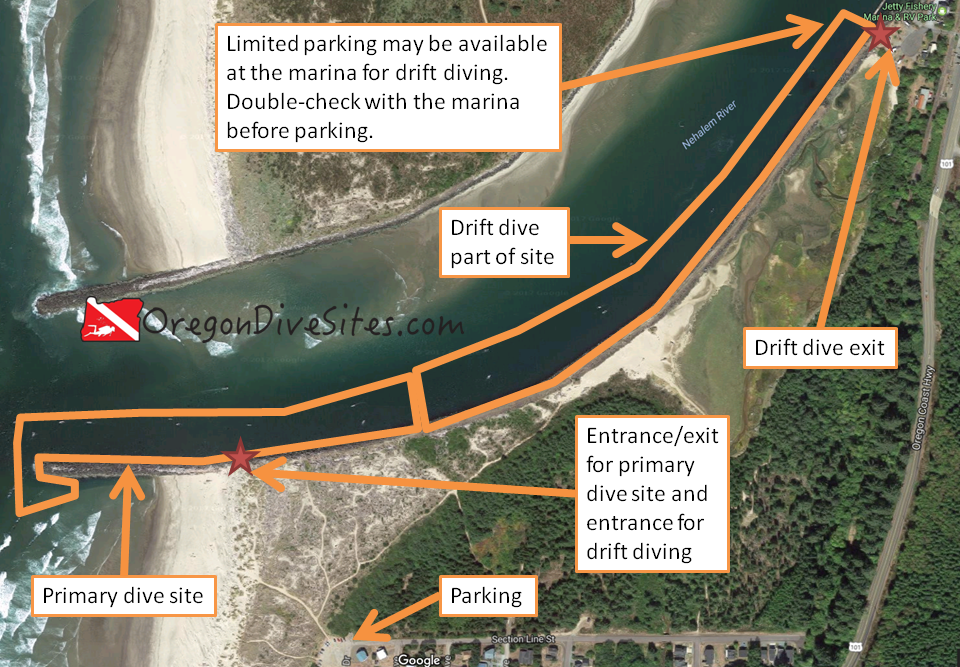
The south jetty at the mouth of the Nehalem river is a fun place to dive that is a little off the beaten track for many divers. The walk to the entrance dissuades many people from attempting this dive but it is well worth the hike if you want to try out a new site. Crabbing and spearfishing are both usually pretty good along the outer part of the jetty. On the inner part of the jetty, it is possible to drift dive way up into the Nehalem river system.
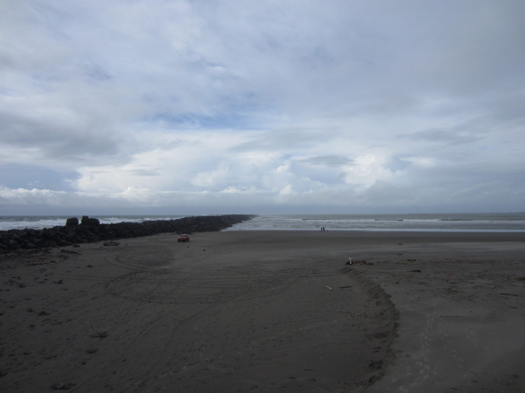
The south jetty as seen from Nedonna Beach.
Site Highlights:
The things people come here for are spearfishing and crabbing, and drift diving. During crabbing season, the deep water along the south jetty is packed with boats that people rent from the marinas up the Nehalem River. Sport fishing is a little less common than crabbing but is just as good for those in boats or sitting on the jetty. Underwater there are ample opportunities to catch your limit of just about everything that the law allows you to take while diving.
For the more adventurous, you can drift dive from the entrance on the jetty all the way back up into the Nehalem River. The first marina up the river is where you want to shoot to exit unless you want to spend several hours lazily drifting along upstream with the incoming tide.
Nearest Town:
The little town of Nedonna Beach is the closest to the dive site. Further north is the town of Nehalem and several other small settlements. To the south, the bigger towns of Garibaldi and Tillamook await. Smaller villages and towns are also just south of the dive site.
From US101 turn onto Beach Street (follow signs for Nedonna Beach). Beach Street will turn to the right (north). Follow it all the way to the end of the road were Section Line Street intersects. There is a public parking area here.
The first marina upriver from the south jetty on the Nehalem River is just off US101 and is well-signed.
Parking:
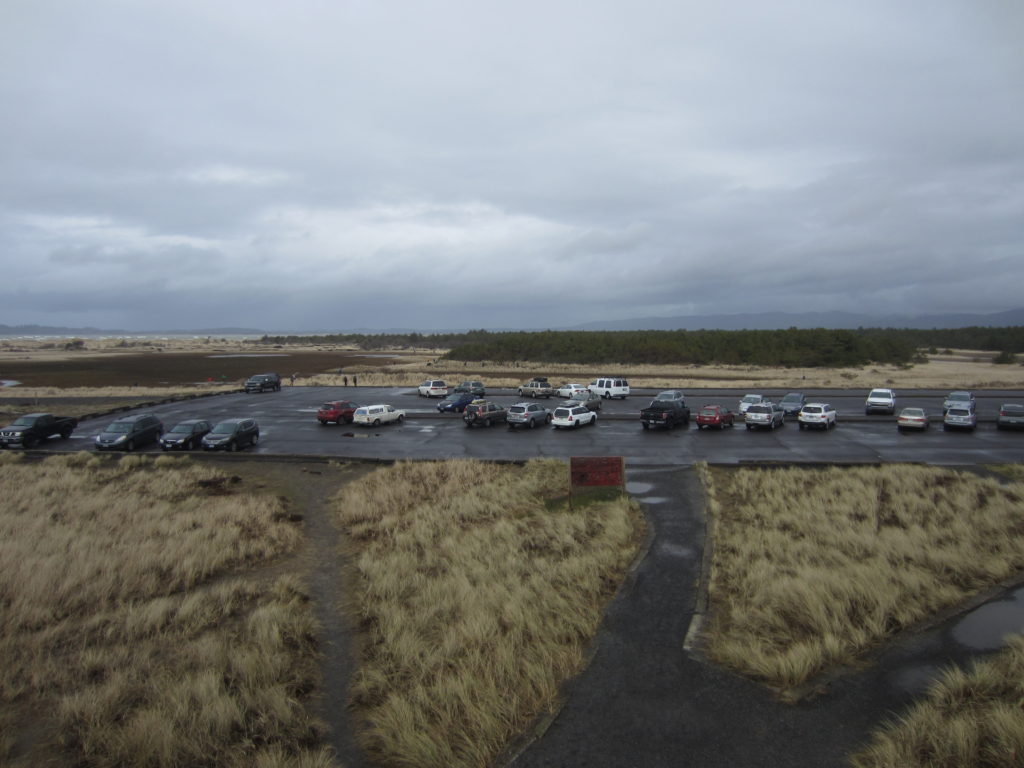
The last time we were here, the parking was free and public at Nedonna Beach. On busy beach days, you might have trouble finding a place to park. Be sure to check the signs when you get to the parking area to make sure it’s still free.
The parking at the marina upriver from the jetty may be free but you need to talk with the marina before you park. You also need to talk with the marina to make sure they’re okay with you using it as an exit point.
The primary dive site runs east-west along the jetty structure. Toward the jetty tip, conditions get rougher. If the weather is bad, stay on the inner part of the primary dive site. If conditions are good, you can dive around the tip of the jetty and a little inward toward the beach. You could even do a surf exit if you really wanted to. However, water gets shallow fast on the south side of the jetty.
The drift dive part of the site follows the Nehalem River up into the Nehalem Bay. We start our dives a few hours before high tide so there is sufficient water still to come into the bay to propel us upstream. You will still have to do some swimming. It’s the best to do this when there is a large exchange between low and high tides to increase the speed at which you go upriver and decrease the need for swimming.
Entrances and Exits:
The primary site entrance/exit and the drift dive entrance are along the jetty. Be sure to scout out where you want to enter based on local conditions. Where the beach grass and jetty intersect is a good place to start looking.
If you’re drift diving, the exit is up at the first marina as you go up the Nehalem River. Be sure to plan your dive well before you try a drift dive here because it is easy to either under or over shoot your exit. You don’t want to be floating along the surface for an hour waiting to exit or end up in the town of Nehalem and have to hitch hike back.
Salt/Fresh:
This is a salt water dive.
Shore/Boat:
This is usually done as a shore dive although if you have a boat to put in at one of the many private marinas or public boat ramps, you can do this site from a boat. If you are doing a drift dive, a support boat can be pretty useful in case you want to exit the water earlier than the first marina.
Normal Conditions:
Out on the jetty tip, conditions are often rough. Surf, surge, current, waves, and other nastiness can be expected most of the time. As you go further in the Nehalem River, conditions steadily improve until all you are really concerned about is boat wakes and fishing line.
Normal Visibility:
Visibility can vary wildly at this site. If you do this site on a calm day in good conditions, you can get 20 feet of viz on the jetty. If a bunch of silt and sediment has been pumping down the river lately, you can end up with very low visibility.
Normal Temperature:
Out on the end of the jetty, expect Pacific Ocean temperatures (45-55F depending on the time of year). Inland, the river starts to influence conditions more. In the summer you might see 60F and in the winter maybe 40F depending on upriver snow melt.
Best Time of Year:
This site is accessible any time of the year due to how large it is. Plan what part of the site you dive based on local conditions.
Max Depth:
Along the outer jetty, you will find 30 feet of water. As you go upriver on the Nehalem, expect 20-25 feet of water depending on how high of a tide you’re riding.
Suggested Special Training:
If you are staying in the primary dive site, open water divers with experience diving Oregon jetties can do the dive. As you go toward the jetty tip in rougher conditions, you will want advanced training and experience in those conditions. If you are doing a drift dive, you should have a drift diver specialty and experience with drift diving on a river system.
Difficulty of Dive:
We rate this as an intermediate dive although the drift dive can get a little more tricky and the jetty tip can be very challenging. If you stay in the primary dive site though, we think this is an intermediate-level dive.
Distance of Walk to Entrance:
You’re in for a 1000+ foot walk to the jetty from the parking area in Nedonna Beach. A cart capable of travel over the sand and some friends who will watch your stuff while you’re diving are both a good idea.
If you do the drift dive, you will either need two cars, a friend to shuttle your car, or be willing to hitch hike to get back to your car. There may be limited taxi service in the area but we suspect they won’t take kindly to wet SCUBA gear in their van.
Surface Swim Length:
No surface swim is needed on the primary dive site. The drift dive could end up with a very lengthy surface swim if conditions are not good for doing a drift dive. There aren’t really any exits between Nedonna Beach and the marina. The distance between the drift dive entrance and drift dive exit is about 3500 feet. Be sure to plan accordingly.
Special Site Notes:
If you’re diving the primary site, do it at high tide. If you’re doing the drift dive, do it only when conditions are right (big tidal exchange) and start your dive an hour or two before high tide so that you’re riding the tide up the river. We don’t recommend trying to do the drift dive in reverse because you could easily overshoot your exit on the jetty and end up getting sucked out to sea which would be unpleasant indeed.
Be sure to talk to the people at the marina before doing a drift dive both about the parking situation and to double-check that they will allow SCUBA divers to exit there. You might be able to talk them into transporting you and your gear back to Nedonna Beach in one of their pickups if it’s a slow day.
It’s a VERY good idea to fly a dive flag both at the primary and the drift dive portions of this site. There is a surprising amount of small boat traffic along the Nehalem River and jetty. A good dive knife is also a good idea in case you encounter fishing line and get tangled.
Closest Local Dive Shops to Get Air Fills and SCUBA Gear:
There used to be a place you could get air fills at the Port of Garibaldi although we can’t confirm if it is still in operation. Otherwise, Astoria has a full service SCUBA shop. In Depoe Bay there is an air fill station that is by appointment only. After that, you’re looking at going inland to Portland or Salem for an air fill or gear service. It’s a good idea to be self-sufficient if you’re diving out on this section of the Oregon coast.
Nearby Restaurants We Like:
There is a lot of good food up and down the coast in this area. You are spoiled for choices here.
Nearby Places to Camp and Diver-Friendly Hotels:
There are a lot of local campgrounds, vacation house rentals, and hotels in the area. We haven’t tried any of the hotels or vacation house rentals so please let us know if you have a favorite that is SCUBA-friendly.
What Other People Have to Say About This Site:
Please write in the comments below your experiences with this dive site!
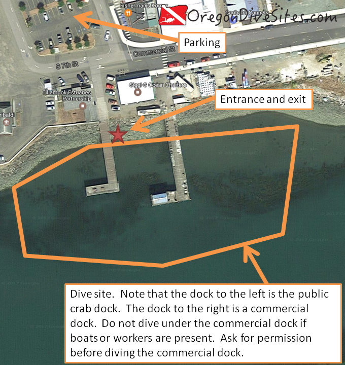
When the weather is too rough to dive the jetties on the mouth of Tillamook Bay and when there are too many people diving The Three Graces, the crab dock at the Port of Girabaldi is a good backup plan. The conditions are almost always favorable here and there usually aren’t many other divers at this site. You do need to plan around the tides though because at low tide, most of this site is a mud flat.
The commercial dock, crab dock, and lumber dock are all along the south riprap at the Port of Girabaldi. There is some confusion in the SCUBA community over which dock is which. We think that the middle dock is the crab dock.
Site Highlights:
This is a good site to go diving if the conditions further toward the mouth of Tillamook Bay are too rough or too crowded. People come to the crab dock in Garibaldi to work on their diving skills in salt water but in relatively benign conditions. While there still is a jetty-style entry to contend with, there is almost never surf, surge, or current here. The nearby lumber dock can sometimes get crowded or have a ship occupying the dock. In that case, the crab dock is a good place to check out for a dive.
Nearest Town:
This dive site is in the middle of Garibaldi, Oregon.
In Garibaldi, turn south on 7th street near the lumber mill. Go all the way to the end of the road.
Parking:
There is ample public parking about a block away from the dive site. The last time we were here, parking was free but the Port of Garibaldi might start charging for parking so be sure to check signs.
The public crab dock runs roughly north-south from the riprap wall out into the shipping channel. The commercial dock just to the east of the public crab dock can be dived at the same time as the public crab dock but you should not dive the commercial dock if a boat is tied up or if there are workers on the dock. Ask for permission from the charter company at the foot of the commercial dock before diving it.
Entrances and Exits:
The entrance/exit is over the riprap at the base of the crab dock. The Port of Garibaldi office to the west might let you enter over the riprap near their building but you need to ask permission before you enter over there.
Salt/Fresh:
This is a salt water dive.
Shore/Boat:
This is a shore dive.
Normal Conditions:
At high tide, this site is usually pretty calm and straight forward to dive. We haven’t seen surf, surge, or much current here. When the tidal exchange starts, the current can pick up. Be sure to dive at high tide both so that you aren’t swimming in a mud flat and so that you aren’t getting pushed around by the current.
Normal Visibility:
Unless the bottom is stirred up, you can usually get 10-15 feet of viz here. Storm conditions can cause more sediment to come down the creeks and rivers in Tillamook Bay and shipping traffic to the Port of Garibaldi can stir things up. Be sure to stay off the bottom because some of the bottom is mud. Other parts of the bottom are sand though.
Normal Temperature:
It’s usually 50-55F here although cold water can invade this area from the streams and rivers up-bay. In the summer it can be warmer on average and in the winter it’s usually a bit colder.
Best Time of Year:
This site can be dived at any time during the year.
Max Depth:
If you bring a shovel and start digging, you might hit 25 feet at high tide.
Suggested Special Training:
This site is accessible to freshly certified open water divers.
Difficulty of Dive:
Aside from climbing over the riprap wall, this is an easy dive.
Distance of Walk to Entrance:
If parking is bad, you may have to walk up to 1000 feet. Usually though you only need to walk a short city block to get to the water.
Surface Swim Length:
You will want to kick out 50 feet from the riprap so the water is a bit deeper before starting your dive.
Special Site Notes:
This site MUST be dived at high tide. The whole area turns into a mud flat at low tide which is no fun to dive in. The Port of Garibaldi is an active port so watch out for boat traffic and fly a dive flag. You should ask permission before diving the commercial dock to the east of the crab dock.
Closest Local Dive Shops to Get Air Fills and SCUBA Gear:
There used to be an air fill station in Garibaldi on Commercial Street near the cannery but we haven’t been able to confirm if it still exists. Please let us know if you find it still open! Otherwise, your closest air fills are available at the full service SCUBA shop in Astoria or one of the shops in Portland or Salem. There is also an air fill station at the time of this writing in Depoe Bay that is open by appointment only.
Nearby Restaurants We Like:
There are some good restaurants in Garibaldi and everyone’s favorite cheese factory is just up the road in Tillamook.
Nearby Places to Camp and Diver-Friendly Hotels:
There are plenty of public and private campgrounds and RV parks in the immediate vicinity. We haven’t stayed in any of the hotels in the area so please let us know if you find one that accepts SCUBA divers.
What Other People Have to Say About This Site:
Please write in the comments below your experiences with this dive site!
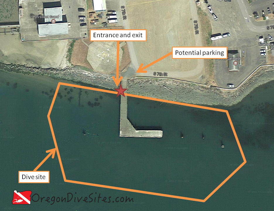
The lumber dock at Garibaldi is a favorite of many Oregon divers. It is a mellow, easy dive that is almost always a good bet at high tide even if a storm is raging out on the jetty at Barview. The water is shallow and there isn’t much current here. The piers have lots of marine life on them to explore. Sometimes you can find a crab or two that are of legal size and occasionally a perch will swim by that’s worth spearing although hunting isn’t the main reason to come dive this site.
The commercial dock, crab dock, and lumber dock at Garibaldi all in one photo at sunset.
Site Highlights:
A quick note on which dock we’re talking about… There is some confusion online and among our SCUBA friends over exactly which dock at the Port of Girabaldi is the “Lumber Dock” that everyone talks about. We believe it is the dock farthest to the west along the south riprap wall that is publicly accessible. Further to the west is the Coast Guard Station and further to the east is what we believe is the “crab dock.” Even further east is a commercial dock.
The main highlight of this and the other sites at the port is that the conditions here are almost always good. When the sites further down the bay, such as the Three Graces, or the South Tillamook Bay Jetty, are blown out due to storms, the docks in Garibaldi allow you to still get in the water and have a good dive. Underwater you’ll find some good marine life on some of the piers and pilings. There isn’t much else to see at this site so don’t get too excited for great hunting or good marine life viewing. For what it is though, the lumber dock is a fun little dive.
This dive site is at the south end of the Port of Garibaldi. Head south on 7th Street past the small RV park. The dive site is just south of the coast guard station helipad.
Parking:
The last time we were here, we could park in the gravel area right in front of the dock. However, we think that this might be closed off now. If it is closed off, there is free parking a block north. Double-check that it’s still free though. You could try asking at the Port of Garibaldi office just to the east of the dive site about if you can get access to and park right next to the dock with your car.
The dock runs south from the riprap wall and then runs east toward several pilings that are used to tie up ships. We have never seen a ship unloading here but it is possible that one might be on this dock. If that’s the case, one of the other docks in Garibaldi is a better choice.
Navigating out to the pilings away from the dock is a fun challenge. If you keep going south, west, or east beyond the pilings, there isn’t much other than a sand and mud bottom.
Entrances and Exits:
You have to climb over the riprap wall at the base of the dock. It’s a bit scrambly but not as bad as some of the jetty entrances in Oregon. It’s a good idea to look at what the better side is when you arrive so you know which way you’re going before you gear up.
Salt/Fresh:
This is a salt water dive.
Shore/Boat:
This is a shore dive.
Normal Conditions:
Conditions here are normally pretty good. It’s rare to have a big wake from a boat in the area. It’s rarer still to have much wave action. There can be a little current during the tidal exchange but it’s nothing compared to out on the jetties. There is boat traffic in the area so it’s a good idea to fly a dive flag. You also might want to take some dive lights with you to check out the little sea creatures on the pilings.
Normal Visibility:
Depending on what the rivers upstream of Garibaldi are doing, you may have 20+ feet of viz or 5 or less feet of viz. Usually it seems to be around 10-15 feet.
Normal Temperature:
The water temperature is usually around 50-55F although it can be cooler in the winter with snow melt and cold rain runoff from the Oregon coast range. In the summer, it can be a bit warmer as well.
Best Time of Year:
You can dive at any time here although you need to dive with the high tide. At low tide, it’s more of a mud flat than a dive site.
Max Depth:
At a very high tide you might find 25 feet of water at the deepest part of the dive site (south of the dock out in the shipping channel). You’re more likely to be around 15 feet deep under the dock.
Suggested Special Training:
This is a good site for open water divers to dive right after they’ve been certified. Aside from the typical Oregon coast jetty scramble, it’s a very easy site to dive.
Difficulty of Dive:
We think this is an easy dive site that anyone can enjoy. The only real difficulty is getting down to the water.
Distance of Walk to Entrance:
Depending on where you can park, you might have to walk 50 feet or maybe up to 1000 feet.
Surface Swim Length:
It’s a good idea to kick out 50 feet along the lumber dock before going down. That gets you to some deeper water.
Special Site Notes:
This is an active port area. It’s a good idea to go talk with the port office before hopping in the water. If there is a ship tied up at the lumber dock, you shouldn’t dive this dock.
Fly a dive flag and bring a light along so you’re safe while you’re exploring and you can check out all the little life on the piers.
Closest Local Dive Shops to Get Air Fills and SCUBA Gear:
There used to be a place in Garibaldi where you could get an air fill. We think it closed a few years back. There also used to be a place in Tillamook but it appears to have closed, too. The closest reliable sources for air fills and gear servicing are in Astoria and Portland. It’s a good idea to be self-sufficient in the Tillamook Bay so you aren’t spending hours driving back and forth to Portland.
Nearby Restaurants We Like:
There are plenty of good restaurants all around the bay.
Nearby Places to Camp and Diver-Friendly Hotels:
We haven’t tried any of the hotels in the area but there is plenty of camping (including RV sites right by the dive site!) around the area. If you go back into the forest in the right places, you can primitive camp, too.
What Other People Have to Say About This Site:
Please write in the comments below your experiences with this dive site!
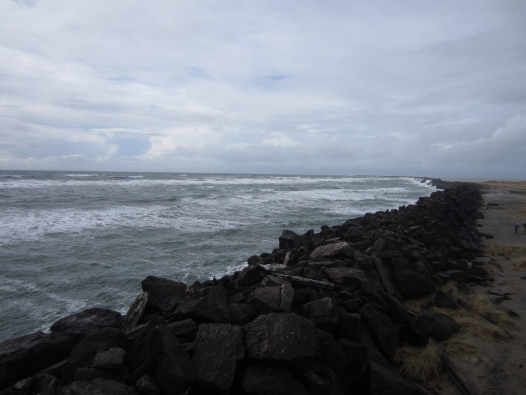
The South Jetty at the mouth of the Columbia River is a dive site that has escaped us for many years. We have never managed to be here during the right conditions to make this dive. However, we are pretty sure that you can dive the jetty in perfect conditions. Someday we’re going to get this dive. Maybe you will beat us to it!
The South Jetty at the mouth of the Columbia River is almost always a rotten place to dive but every once in a while the weather is just right and this is an enticing place to dive. Someday we’ll manage to dive here.
Site Highlights:
The main drive for us to dive here is the novelty of diving on the most northwesterly point of Oregon. Because conditions here are almost always rough, we have never managed to get in the water. We expect that there is good spearfishing on the jetty. There may also be some pieces of old shipwrecks but we aren’t sure.
Head to Fort Stevens State Park and then follow signs for the Columbia River. Look for Parking Lot C signs. If you are going to drive on the beach, check locally for what permits you need (probably an Oregon OHV permit) and where access is available to get onto the beach.
If you’re accessing the jetty from a boat, the Hammond Boat Basin on the Columbia River is the closest place to put in a small boat. Make sure you have a good captain who knows the Columbia Bar. We know of someone who died on the bar in his small open boat. His body was never found. There’s a reason that the Columbia River’s mouth is part of the Graveyard of the Pacific.
Parking:
There is a big parking lot right at the base of the jetty. Otherwise, you can drive on the beach with proper permits (Oregon OHV permit) and at the right time of year. This will get you closer to the site.
We have not had to pay for parking at Lot C but this could change. Make sure before you park if you need to pay or not.
The site is mostly west-east. You want to stick close to the rocks and not stray far away. There can be a lot of strange currents in the area that change frequently. The south side of the jetty is deeper than the north side close into the shore. Farther west on the jetty, it gets deeper on both sides.
Entrances and Exits:
If you’re doing a shore entrance or exit, right at the base of the jetty is where you want to hop in. If you drive onto the beach on either side of the jetty, the entrance will be easier than climbing on the massive jetty rocks.
If you’re doing this as a boat dive, it’s worth heading toward the tip of the jetty for deeper water. Make sure you check out the proper nautical chart and have a good boat captain. The tip of the jetty goes underwater and can be hazardous even in good conditions.
The beach on the north of the Columbia RIver’s south jetty is very long. You will have to walk through a lot of shallow water before you find a place worthwhile to go underwater.
Salt/Fresh:
This is a salt water dive.
Shore/Boat:
The south jetty on the Columbia River can be done either as a boat or a shore dive. When the conditions finally align with our plans, we expect we’ll do this as a shore dive.
Normal Conditions:
Normally it’s way too rough to dive here. Every time we have tried, the conditions are rotten. In absolutely ideal conditions, you will still have to contend with surf, surge, and current.
Normal Visibility:
Based on what we have been told by other divers and our own experience on nearby jetties, we expect visibility to range from 5 to 15 feet depending on conditions.
Normal Temperature:
This site is exposed directly to the open ocean so water temperature tracks ocean temperature. Expect to see temperatures between 45F and 55F.
Parking Lot C is the closest you can get on pavement to the jetty. It’s a good place to stage before making the climb over the jetty or the long walk to the north beach.
Best Time of Year:
Summer and early fall when no storms are predicted is the best time to try your luck at getting a calm day at the mouth of the Columbia River.
Max Depth:
At the very tip, nautical charts show about 65 feet of water. Along the jetty where you can dive from shore, the north side won’t get much below 15-20 feet at high tide while the south side can get up to about 30 feet.
Suggested Special Training:
You really should have rescue diver training and a lot of experience diving jetties in Oregon before you attempt this. Even then, this can be a dangerous site.
Difficulty of Dive:
This is an advanced dive that requires lots of planning and good conditions. Diving in anything less than ideal conditions is just asking for trouble.
Distance of Walk to Entrance:
If you park in C Lot, you’ll be walking about 300 feet plus a jetty scramble for the south side of the jetty or about 1500 feet plus a long slog through shallow water (up to 2000 feet!) for the north side of the jetty. It’s possible the north side might have quicksand in the shallows so be very careful.
Surface Swim Length:
No surface swim is necessary on most of the south side unless you’re starting from the beach in which case you might have to swim 1000 feet for deep enough water. On the north side, you’re looking at 1000+ feet of swimming to get to deep water.
Special Site Notes:
To dive on the beach, you need a permit (Oregon OHV). Check locally to see what the rules are.
This site is not one that you can just go and do any day of the week. Weather needs to be good and ocean conditions need to be calm. Even then, the Columbia River pumps out a LOT of water and there are a lot of strange and unpredictable currents around the jetty.
Closest Local Dive Shops to Get Air Fills and SCUBA Gear:
There is a full service SCUBA shop in Astoria with air fills.
Nearby Restaurants We Like:
Look for the little tugboat on the back of a trailer in downtown Astoria for really good fish and chips.
Nearby Places to Camp and Diver-Friendly Hotels:
The state park has camping available. We haven’t tried any of the hotels in the area. Please let us know if you are aware of diver-friendly lodging in greater Astoria.
What Other People Have to Say About This Site:
Please write in the comments below your experiences with this dive site!
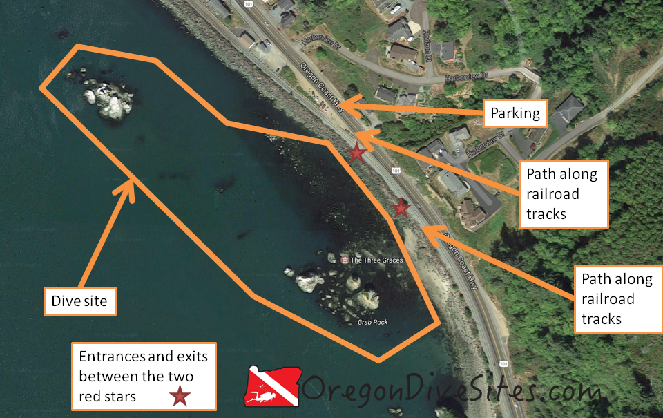
The Three Graces, otherwise known as Crab Rocks, is a beautiful dive site right off US101 just west of Garibaldi, Oregon. We love coming here to dive for the scenery above and below water. The complex and ever changing currents make this a fun and challenging site to navigate. We have had great luck spearfishing and crabbing here in the past.
Site Highlights
This is one of the easiest sites to access in Tillamook Bay. The entrance and exit are easy and straight forward compared to the jetty dive sites. The scenery is breathtaking. The crabbing and spearfishing are pretty good. And the tricky currents that are constantly changing make this a fun navigation puzzle.
Look for the parking on the west side of US101 just north of the Three Graces.
Parking:
Parking is free and plentiful. We have heard from some of our SCUBA friends that sometimes people’s cars get broken into here if a bunch of expensive looking equipment is left visible inside. When we go diving here, we usually take some friends along who aren’t divers so that they can make sure our stuff is safe while they enjoy the scenery.
The main site is around the Three Graces. Stick close to the rocks and remember than heading east gets you to land. Good navigation skills are a big help here especially when the current starts playing tricks on you.
The rock further north (called Painted Rock on NOAA navigational charts) can also be dived although a longer surface swim is necessary to reach it. There are a few smaller rocks in between that might be worth checking out if you feel like navigating to them.
Entrances and Exits:
The entrance and exit is along the railroad tracks. Follow the path that crosses the railroad tracks and pick your favorite spot to climb over the low jetty to get to the water. One spot is much easier than the others. Scout ahead before you jump in.
Salt/Fresh:
This is a salt water dive.
Shore/Boat:
This is a shore dive.
Normal Conditions:
This is so far in the Tillamook Bay that you won’t have any surf or surge. You will have current though. The current swirls around the Three Graces in unusual and somewhat unpredictable patterns. It makes this a great navigation puzzle site.
Normal Visibility:
We have seen anywhere from 10 to 25 feet of visibility depending on time of year and upstream river conditions.
Normal Temperature:
This site can be as cold as 38F and as warm as 57F depending on what is happening upriver in the Coast Range. Cold winter rains can really chill the water here while hot summer days can make the water pretty warm.
Best Time of Year:
We like diving here in the spring and fall the best although the site is diveable year round.
Max Depth:
We once logged 51 feet here in some potholes by the base of the three graces before but most of this site is pretty shallow.
Suggested Special Training:
This site is accessible to anyone with open water SCUBA certification although you will want to have sharp navigation skills because of the complex nature of this dive site.
Difficulty of Dive:
We rate this as an easy beginner dive because there isn’t much that can go seriously wrong at this site. You would have to really work at it to get sucked out to sea from here. There is boat traffic in the shipping channel but sticking close to the rocks you won’t have any troubles with that.
The entrance does require a small jetty scramble but it’s nowhere near as intense as many of the other jetties along the Oregon coast.
Distance of Walk to Entrance:
It’s about a 200-300 feet walk to the best area to enter.
Surface Swim Length:
You will want to surface swim maybe 100 feet out to get to deeper water before you descend.
Special Site Notes:
At low tide, this site is really not diveable. This is much more enjoyable at high tide.
Taking gear to spearfish or crab can be a fun way to spice this site up if you have gone diving here before. We have a list of gear that we use when we go spearfishing and crabbing over at our Gear We Use page.
[Underwater Map of Dive Site Coming Soon!]
Closest Local Dive Shops to Get Air Fills and SCUBA Gear:
There used to be a dive shop in Tillamook although we haven’t been able to confirm in a few years if it is still open or not.
Nearby Restaurants We Like:
Garibaldi and Rockaway Beach both have good restaurants.
Nearby Places to Camp and Diver-Friendly Hotels:
Tillamook County Parks operates several campgrounds in the area. We haven’t tried any of the local hotels so please let us know if you know of a good hotel that is SCUBA diver friendly!
What Other People Have to Say About This Site:
Please write in the comments below your experiences with this dive site!
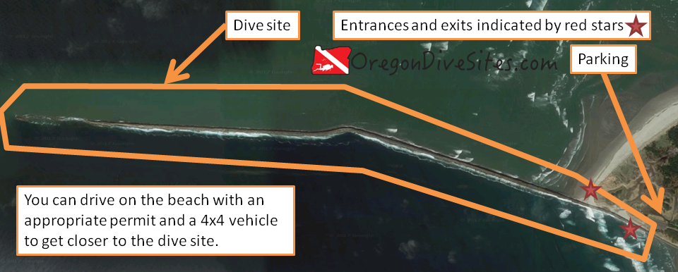
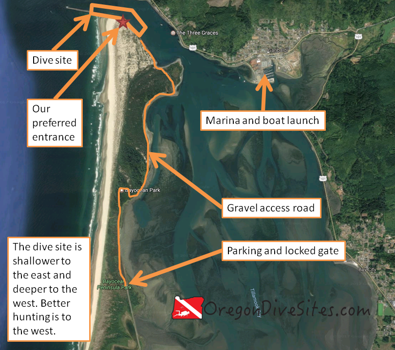
The south jetty of Tillamook Bay does not see very many SCUBA divers because of the difficulty of access. The road out to the jetty is almost always gated and locked. With a boat launched from one of the marinas in Tillamook Bay, you can easily reach the site. We have heard of a few people surface swimming from the north shore at the Inner North Jetty dive site but that is an epic surface swim where you have to fight the current and dodge boat traffic. With a hand cart and patience, you can lug all of your dive gear from the parking area along the gravel road to the jetty a few miles away.
The main reason people go dive the south jetty is to spearfish. Because so few people dive along the jetty, the fish tend to be bigger and more plentiful than on the north jetty (at least in our experience). You also get to put the feather in your SCUBA cap of diving a site that not many people ever get to dive.
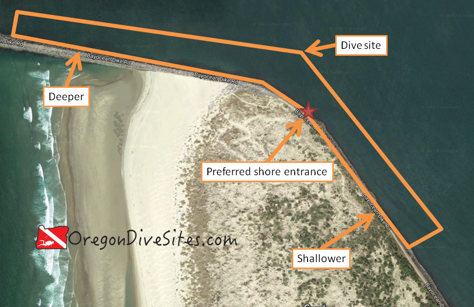
By Bill Johnson, U.S. Army Corps of Engineers [Public domain], via Wikimedia Commons. The south jetty (on the right) doesn’t get many SCUBA visitors but it is worth the difficulty of accessing the dive site if you want do some good spearfishing.The old abandoned town of Bayocean is what drove the construction of the jetties on the mouth of Tillamook Bay. Depending on what path or road you take through the Tillamook County Bayocean Peninsula Park, you might catch a glimpse of a few foundations and the memorial sign at the old town square. Most of the town fell into the ocean due to coastal erosion.
See page for author [Public domain], via Wikimedia Commons. The old natatorium and dance hall at Bayocean before they fell into the sea.
Site Highlights:
The reason anyone dives here is for the spearfishing. Otherwise this is a pretty typical Oregon jetty dive that has really difficult access.
Nearest Town:
The little unincorporated town of Barview is across the channel. The town of Garibaldi is just up the bay and on the other side. Tillamook is further south.
If you’re going to access this site via boat, go to Garibaldi and put your boat in at the marina there.
If you’re going to do the long hike to the dive site, in Tillamook take the Netarts Highway to the west from downtown and then turn onto Bayocean Road just after you cross over the bridge. Follow Bayocean Road all the way to the parking area at the Tillamook County Bayocean Peninsula Park.
If you’re going to do the surface swim because you’re practicing for an Iron Man or because you like punishing yourself, the parking area for the Inner North Jetty dive site is the best place to park.
Parking:
In Garibaldi at the boat launch, there is plenty of parking. At the Bayocean Peninsula Park parking lot, there usually is plenty of parking.
The site hugs the jetty wall from southeast to northwest on the inner part and then after a bend in the jetty, from east to west. The western area is deeper than the eastern area. You could theoretically dive the jetty tip if you wanted but the conditions out there are almost always very rough and not something that would be all that fun to do.
There is one area on the jetty wall near where the jetty hooks to the west that is a little lower and easier to scramble over. However, you can enter or exit just about anywhere along the wall.
Salt/Fresh:
This is a salt water dive.
Shore/Boat:
The south jetty can be done either as a shore dive or a boat dive. A boat dive is significantly less physically demanding although a competent captain is needed to navigate dropping off SCUBA divers along the jetty wall.
If you do this as a shore dive, prepare for a several mile long hike towing a cart with all of your gear in it.
Normal Conditions:
This site almost always has a wicked ripping current along the south jetty. The tidal exchange into and out of Tillamook Bay is pretty huge and there is very little slack tide. Stay close to the jetty rocks and plan your dive to stay safe. You don’t want to get sucked out to sea or pushed way up into the bay.
There can be surf and surge, especially the farther out you go on the jetty toward the ocean. We strongly suggest you assess the conditions and only dive where you feel comfortable diving.
Normal Visibility:
Viz here is usually around 15 feet although it can be better in fair weather. The bottom is mostly sand so you don’t need to worry too much about stirring up mud.
Normal Temperature:
Water temperature usually is around 42-55F.
Best Time of Year:
The best time of the year to dive here depends on if you are doing the long walk from the parking area or if you are taking a boat. If you’re taking a boat, just about any time is decent to dive here as long as conditions aren’t too rough. If you’re hiking, we suggest doing it in the fall or spring when it isn’t too sunny or warm so that you don’t roast on the long slog to the dive site.
Max Depth:
On the westerly part of the jetty, you can find 40 feet sometimes. On the inside eastern part of the south jetty, the depth is more like 15-20 feet.
Suggested Special Training:
We suggest having advanced open water training and experience diving other jetties in Oregon, such as the Florence north jetty SCUBA park and “crab hole” where there is an easy entrance and exit and more forgiving conditions.
If you are doing this as a boat dive, you need experience on how to safely enter and exit a boat.
If you’re planning to go more toward the jetty tip, rescue diver training, drift diver training, and a lot of experience in very rough conditions is necessary.
Difficulty of Dive:
The dive itself is an intermediate difficulty site because of the jetty entrance and exit, and the current. However, the huge hike from the parking area makes this a shore dive for only the most fit of people. If you’re doing this from a boat, weekend warriors shouldn’t have much issue.
Distance of Walk to Entrance:
If you do the long walk from the parking area, you have several miles to lug all your gear. A wheeled cart will make your life much easier.
Surface Swim Length:
There isn’t any need to surface swim unless you are accessing this site from the inner north jetty dive site. If that’s the case, then you are looking at a 1000 foot surface swim with current and shipping traffic to dodge.
Special Site Notes:
We suggest you contact the Tillamook County Parks Department to see if you can arrange to have the gate opened to drive out to the jetty rather than having to walk. We have not been successful with this approach yet but if enough people start asking, perhaps the parks department will start opening up the gate more often for SCUBA divers.
[Underwater Map of Dive Site Coming Soon!]
Closest Local Dive Shops to Get Air Fills and SCUBA Gear:
There used to be a shop in Tillamook that did air fills although we can’t confirm if it is still open. Please let us know if you know of a local shop!
Nearby Restaurants We Like:
Tillamook has a lot of good food. Oceanside and Netarts just down the road have good food as well. If you’re coming in from Garibaldi on a boat, there are also some restaurants there.
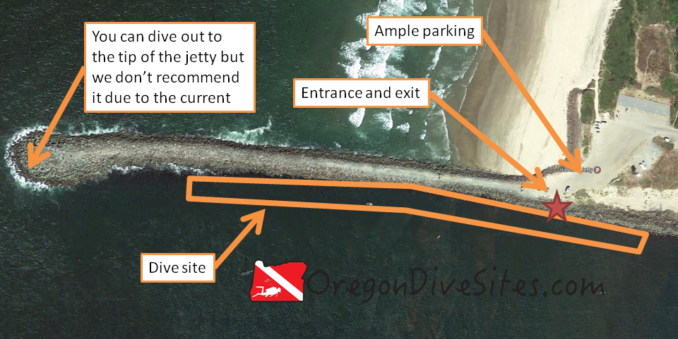
The outer north jetty at the Tillamook County Barview Jetty Park is a good SCUBA site to visit if you want to go crabbing or spearfishing. Big lingcod lurk on the outer reaches of the jetty where the saltwater of the Pacific Ocean mixes with the freshwater from Tillamook Bay.
By Bill Johnson, U.S. Army Corps of Engineers [Public domain], via Wikimedia Commons. The north Barview jetty is a great place to dive if you want to go spearfishing or crabbing. The middle north jetty dive site has a shorter walk than the inner north jetty dive site but is a little more exposed to ocean conditions.
Site Highlights
The reason we dive this site and put up with the strong current and difficult entrance is to go hunting. Spearfishing for monster lingcod, rockfish, and other fish is really fun on the outer north jetty. Aside from a few minutes of slack tide, the current is always roaring here and will easily suck you out to see if you aren’t careful. It is still a fun site to dive in spite of the current for the thrill of finding those big fish that everyone desires.
Nearest Town:
The little unincorporated community of Barview, Oregon further inland along the jetty. The towns of Garibaldi and Tillamook are a bit further south.
Follow signs for the Tillamook County Barview Jetty Campground and keep going along Jetty Road until you come to the parking lot at the beach. Park over toward the jetty to minimize your surface walk.
Parking:
There is usually plenty of parking here. The last time we went to this site, parking was free but this could change.
The dive site runs roughly east-west along the north jetty for Tillamook Bay. The farther out you get on the jetty, the rougher the conditions will get. We don’t recommend going all that far out toward the jetty tip because there are almost always big waves, surf, and surge on the jetty tip. The current can also easily pull you out to sea which would be no fun.
Entrances and Exits:
Right by the parking area there are a few places that are more easy to scramble over the jetty rocks. If you get in a pinch, you can climb up on the jetty further out toward the ocean or treat this as a drift dive and exit either at the middle or inner dive sites on the north jetty.
Salt/Fresh:
This is a salt water dive.
Shore/Boat:
This is a shore dive.
Normal Conditions:
This site almost always has a wicked current that will try to suck you out to see or in toward Tillamook. When the waves are lined up just right, big breakers can wash over the jetty and the surge can be huge. The further west on the jetty you go, the more the conditions deteriorate.
Normal Visibility:
You usually have 10-15 feet of visibility at the outer north jetty dive site.
Normal Temperature:
Water temperature usually runs between 48 and 57F at this site.
Best Time of Year:
The only time you want to go diving here is when the ocean is relatively calm. With the wild Pacific Ocean just a few hundred feet away, you need to watch the surf, marine, and weather forecasts. Luckily there are plenty of other dive sites around Tillamook Bay for you to check out if this site is no good to dive.
Max Depth:
Out toward the tip of the jetty you will see a depth of around 45 feet. further east, you will see more like 35 feet of water.
Suggested Special Training:
Advanced open water training is a good idea here. Rescue diver training is also a good idea. You need to have a safety sausage (we have one we highly recommend on our Gear We Use page) in case you get into trouble and get sucked out to sea. Remember don’t try to fight the current if you get sucked out. Go parallel to shore and look for somewhere that the current is carrying you back toward land to make your exit.
If you do have to do a beach exit after getting sucked out to sea, don’t forget your training. Getting through breakers can be very challenging for even the most experienced divers.
Difficulty of Dive:
We rate this as an intermediate dive as long as you dive this site in good conditions and are mindful of how far out along the jetty you go. If you decide to head for the tip, this becomes an advanced dive.
Distance of Walk to Entrance:
If the parking close to the jetty is full, then you might have to walk a hundred feet or so. Usually you can park right next to the jetty, scramble over the rocks, and you’re in the water.
Surface Swim Length:
There is no surface swim here unless you for some reason want a surface swim.
Special Site Notes:
There is boat traffic that comes in and out of the Tillamook Bay. Don’t stray into the channel. As we’ve said elsewhere on this page, be very mindful of the current and don’t go too far out on the jetty unless you really know what you’re doing. While this is the outer north jetty dive site, we specifically don’t include the tip of the jetty in this site because of the difficulty of that area.
[Underwater Map of Dive Site Coming Soon!]
Closest Local Dive Shops to Get Air Fills and SCUBA Gear:
There used to be a local dive shop in Tillamook. We aren’t sure if it is still there or not. If you know of a nearby SCUBA shop, please let us know!
Nearby Restaurants We Like:
There are quite a few restaurants up and down US101. If you have a favorite, please drop us a line and we’ll add it here.
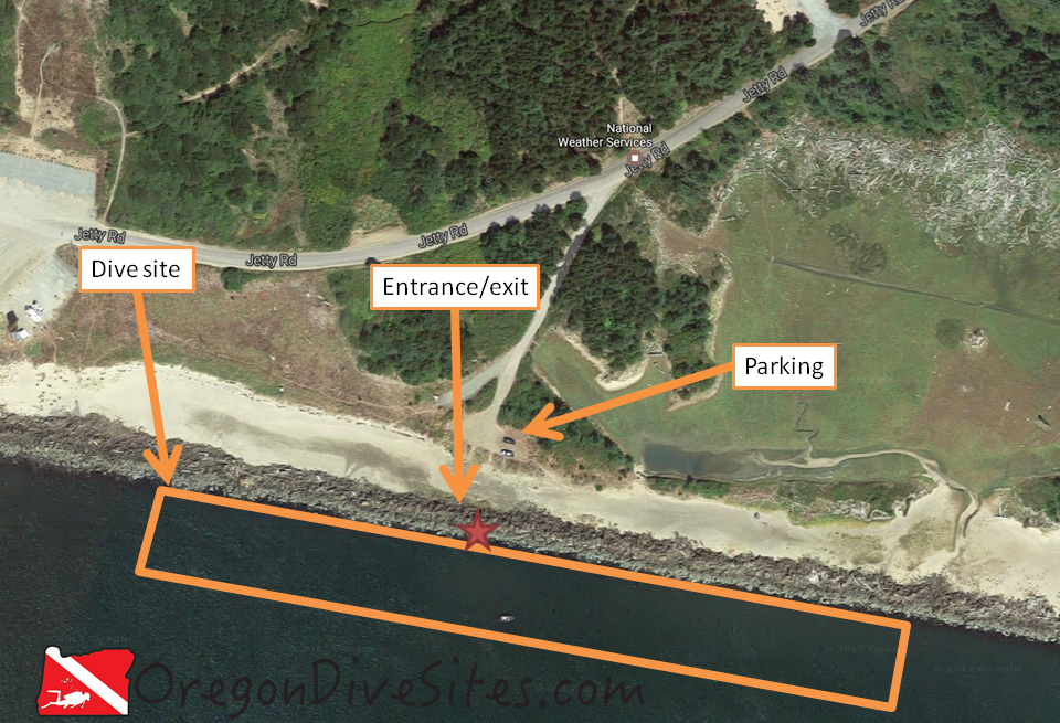
While the parking can be tight, the middle north jetty dive site on the Barview north jetty is a good place to go diving if you want to spearfish or go crabbing. The current is usually too strong to stop and look around for very long but the hunting is good. The Tillamook County Barview Jetty Park and Campground is very close and could serve as a nice home base for a few days of diving around Tillamook Bay.
By Bill Johnson, U.S. Army Corps of Engineers [Public domain], via Wikimedia Commons. The north Barview jetty is a great place to dive if you want to go spearfishing or crabbing. The middle north jetty dive site has a shorter walk than the inner north jetty dive site but is a little more exposed to ocean conditions.
Site Highlights
The main highlight at this site is spearfishing and crabbing. The tidal exchange produces too much current here to go slow and look at all of the micro marine life.
Nearest Town:
Barview, Oregon is the closest unincorporated town. Garibaldi is the closest larger town and Tillamook is a bit further south.
Follow signs from US101 for the Tillamook County Barview Jetty Park. Follow Jetty Road west and look for the left-hand (southerly) turn. If you go too far, you’ll end up at the end of the road and the outer north jetty dive site.
Parking:
There is limited parking at this dive site. We have seen this site’s parking full on busy weekends. The last time we went here, we did not pay to park although that may change.
The site runs generally east-west along the north jetty. Keep close to the jetty and don’t stray into the shipping channel.
Entrances and Exits:
This is a difficult jetty entrance. We highly recommend that you walk the entrance before you don your SCUBA gear to make sure you have a solid plan for where you want to crawl over the jetty. It’s a good idea to take something to mark your exit point so that you can find it easily when you surface. A dive flag, like the one we recommend on our Gear We Use page, works as a good marker and lets nearby boats know that you’re along the jetty.
Salt/Fresh:
This is a salt water dive.
Shore/Boat:
This is a shore dive.
Normal Conditions:
You WILL find current at this site. Depending on how the waves are coming into the coast, you may encounter surge and surf as well although it is rare to get much surge here and rarer to have surf.
Normal Visibility:
Visibility is normally 15 feet on a good day. The best visibility is at high tide. If a big storm has been dumping rain above Tillamook Bay, visibility will be reduced.
Normal Temperature:
We have seen water temperatures here between 48 and 57F depending on the time of year.
Best Time of Year:
The middle north jetty dive site can be dived at any time throughout the year. We usually like going here during crabbing season though.
Max Depth:
At high tide, you can find 40 feet of water along the middle north jetty.
Suggested Special Training:
We suggest having advanced open water training and be comfortable with climbing over jetties. This site always has a good current so be prepared to dive in strong current. Some people will do this as a drift dive and come out either at the inner north jetty dive site or the outer north jetty dive site.
Difficulty of Dive:
We think this is an intermediate dive due to the current and the jetty entrance.
Distance of Walk to Entrance:
It’s about 75 feet from the parking lot to the jetty.
Surface Swim Length:
No surface swim is needed as long as you’re decent with navigation.
Special Site Notes:
The current here can really rip. We usually prefer to dive this site when the tide is still coming in and exit just after slack tide.
[Underwater Map of Dive Site Coming Soon!]
Closest Local Dive Shops to Get Air Fills and SCUBA Gear:
There used to be a local dive shop in Tillamook although we aren’t sure if it is still in business. Please let us know if you have up to date information!
Nearby Restaurants We Like:
There are restaurants up and down US101 near this dive site. If you have any favorites, please let us know!