Categories
Central Oregon Coast

Umpqua River South Jetty and Triangle Jetty

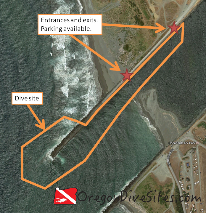
The Umpqua River South Jetty and the area known as the Triangle Jetty just outside the town of Winchester Bay on the (unsurprisingly named) Winchester Bay is a great place to explore a unique jetty structure.  Nowhere else that we know of along the coast in Oregon can you find a triangle jetty with water that is almost always calm even when the see is violently rough.  It is important to note that the shellfish being commercially grown are strictly off-limits to recreational divers.  It is a crime to attempt to harvest any of the shellfish.  Don’t give other recreational SCUBA divers a bad name!

umpqua south jetty and triangle jetty
Imagery ©2017 Google, Map data ©2017 Google.
The Umpqua South Jetty and the area known as Triangle Jetty where commercial shellfish are grown is a good place to go dive in most ocean conditions. When the weather is rough, you can dive inside the triangle jetty. When it is good weather, you can dive on the outside of the jetty.


We can’t confirm it with our own eyes but based on videos we’ve found on YouTube, such as this one, it appears there is some sort of wreckage to discover along the jetty.  We suspect this could be a small boat or maybe a rail car that fell off the tracks when the jetties were originally constructed.  One way or another, we now have the triangle jetty and the whole south jetty complex on the Umpqua River on our short list of places to revisit in the very near future.  If you have more information on this wreck, including location and what it might be, please comment below!

Nearest Town:

The nearest town is Winchester Bay.  A little further inland is Reedsport, Oregon.

GPS Coordinates:

43.665295, -124.211310


Special Directions to Site:

From the town of Winchester Bay, take Salmon Harbor Drive south and west.

Parking:

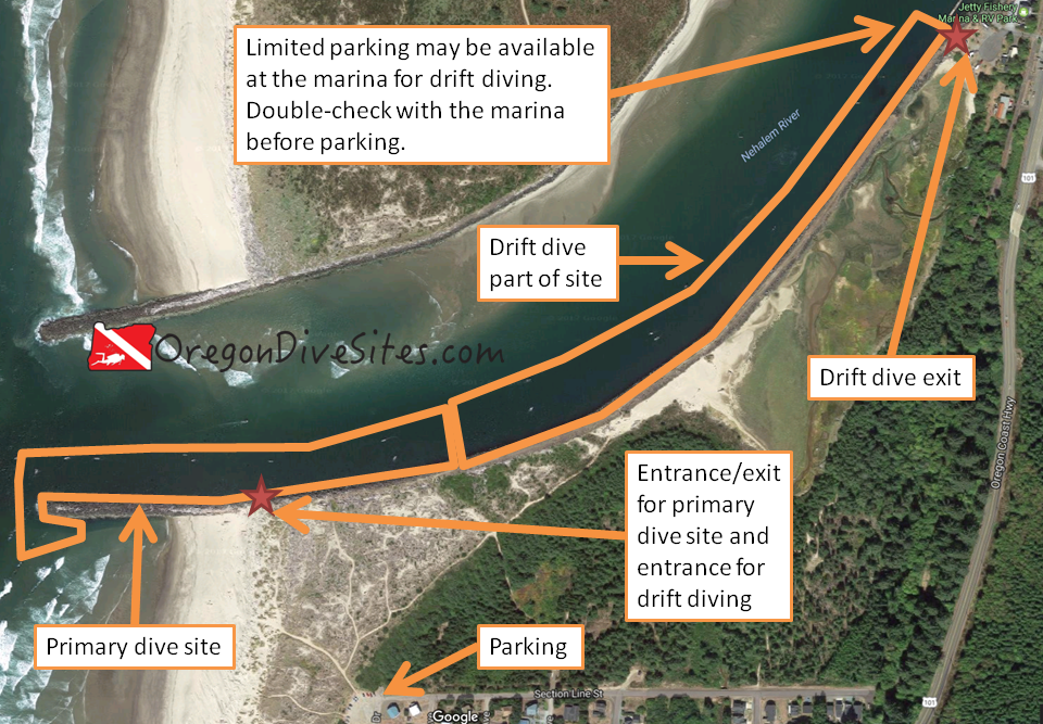
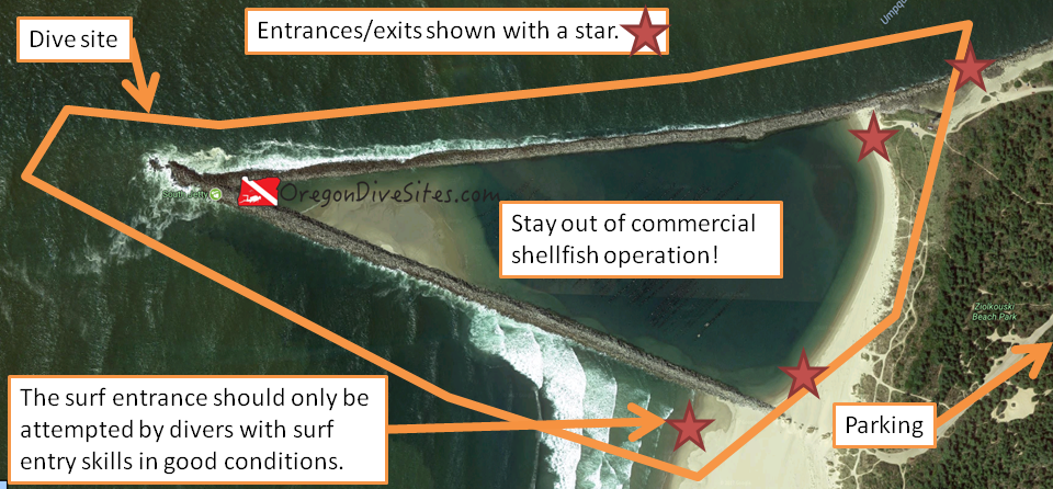
There are several locations that you can park at depending on how crowded it is and where you want to enter/exit.  On the south jetty (north side of the dive site), you can drive right out along the jetty.  We think that you can also drive along the beach here to access the triangle jetty area where the commercial shellfish are grown.  There even appears to be access down to the south side of the triangle jetty.  However, before you drive out onto the sand, double-check the local OHV laws and make sure you have an OHV sticker on your vehicle.

If you don’t want to get into the sand, there are day use parking areas along Salmon Harbor Drive.

Site Orientation:

There are three distinct areas on this dive site.  The first that most people are the most interested in is the inside of the triangle jetty.  This is an active commercial shellfish business area.  Stay well clear of the shellfish platforms and hanging shellfish lines.  There is risk of entanglement in all of the equipment used by the commercial operation.  There may also be discarded shellfish lines underwater that you could become tangled in.

The second area is along the south side of the triangle jetty all the way out to the jetty tip where the south jetty reaches the sea and then partway along the inside of the south jetty.  This area is often rough.  Sea conditions usually preclude people from SCUBA diving here.  However, there is generally good spearfishing and crabbing in this area.

The third area is along the eastern part of the south jetty in the Umpqua River channel.  This area is usually pretty decent to dive and has decent spearfishing and crabbbing.

Entrances and Exits:

There are a multitude of entrance and exit options at this site.  You can crawl over jetty rocks on the south jetty to gain entrance to the Umpqua River channel.  You can practice your surf entrances/exits along the outer south side of the triangle jetty.  You can do an easy beach entrance into the interior of the triangle jetty.  This site has it all.

Please note that the surf entrance/exit can be dangerous and should only be attempted by divers who have sufficient training and experience.  Conditions can rapidly change and make this an untenable entrance/exit.  Have a backup plan!

Salt/Fresh:

This is a salt water dive.

Shore/Boat:

This is a shore dive.

Normal Conditions:

If you are inside the triangle jetty area, there is almost never any bad condition to find.  The area isn’t even really impacted by tidal changes.  No real current, almost never any surf or surge, and extremely rarely are there any waves in here.  People can dive this area just about any time of the day or night and any day of the year.

Along the southern outside area of the triangle jetty, past the tip of the south jetty, and into the mouth of the Umpqua River, you will likely encounter surf, surge, current, and waves.  Watch conditions closely if you are going to dive this area.  There are only a few days a year that parts of this area is accessible.

On the inside of the south jetty in the Umpqua River channel, conditions are often better than on the outside of the jetties.  However, you need to be cognizant of the current.  Dive with the tide.  In really bad weather, you can have surf, surge, waves, and related nastiness.  In a worst case scenario, scratch a dive here and instead go dive the inside of the triangle jetty.

Normal Visibility:

Depending on the time of year and recent storms, you can range from 40 feet of viz off the tip of the south jetty on down to less than 5 feet of visibility along the outer south side of the triangle jetty.  Usually though you’ll find 20-25 feet of vis.

Normal Temperature:

Water temperature varies between 48 and 60F depending on the time of year.  If there has been recent snow that is melting in the mountains that feeds the Umpqua River, the river channel can be a bit colder.

Best Time of Year:

The inside of the triangle jetty can be dived any time of the year even in bad sea conditions (use common sense though!).  The south jetty along the Umpqua River is good most of the year although when the upwelling happens over the summer, visibility isn’t amazing.  The southern outside part of the triangle jetty is a very finicky place to dive and usually only will be accessible a few days a year in the summer.

Max Depth:

Off the tip of the south jetty, you can find up to 50 feet of water at high tide and with optimal bottom conditions.  When sand moves around, you won’t find it that deep.  In the triangle jetty, you’ll find maybe 25 feet of water but usually shallower unless there has been dredging recently.  On the south side of the triangle jetty, you might find 30 feet of water.

Suggested Special Training:

Inside the triangle jetty, open water divers with some experience at other dive sites should have a good time.  In some of the rougher areas outside of the triangle jetty and on the south jetty, the diving can become very advanced and challenging.  Specific training in surf entry/exit is needed if you plan to do that.

Difficulty of Dive:

We rate this as an intermediate dive although if you try to dive the jetty tip or the exposed portions of the triangle jetty, you can find yourself in extreme or impossible conditions.  Inside the triangle jetty there are entanglement hazards and machinery hazards so pay attention!

Distance of Walk to Entrance:

Depending on where you park and where you’re walking to, you will either walk 50 feet or up to 1000 feet.

Surface Swim Length:

No surface swim is needed at any of the areas in this site.

Special Site Notes:

Remember that it is illegal to interfere with the commercial shellfish operation.  We know those oysters look tempting but DON’T DO IT!  You will give SCUBA divers a bad name!

Closest Local Dive Shops to Get Air Fills and SCUBA Gear:

As of the time of writing this, there are no dive shops or air fill stations along the Umpqua River near Winchester Bay.  There is (or at least was the last time we checked) a shop in North Bend to the south.  Otherwise you’re looking at heading inland to Eugene.  Check out the updated list of local dive shops in Oregon to see where the closest shop is to your dive.

Nearby Restaurants We Like:

There are a couple good restaurants in Winchester Bay and further inland at Reedsport.

Nearby Places to Camp and Diver-Friendly Hotels:

There is a campground right next to this dive site and several others in the immediate vicinity.  In Reedsport there are the normal hotels although we haven’t tried any of them so we can’t comment on if they are friendly to SCUBA divers or not.

What Other People Have to Say About This Site:

Please write in the comments below your experiences with this dive site!


Categories
Southern Oregon Coast

Sunset Bay

Sunset Bay and the associated beach is a great place to dive just south of Coos Bay on the southern Oregon coast.  The bay provides good protection from rough Pacific Ocean conditions that are prevalent along the Oregon coast.  The sandy beach is a good place to practice mellow surf entrances and associated skills.  Parking and access can be a challenge on popular weekends when the beach is covered with families and the parking lot is completely full.


Sunset Bay
Imagery ©2017 Google, Map data ©2017 Google.
Sunset Bay is a good place to practice surf exits and entries in a relatively mellow environment.

In spite of the summer crowds, this site can be a lot of fun to dive.  Along the outer rims of the bay, rocks provide ample cover for marine life.  For those with a boat or who are okay with a lengthy surface swim, you can reach the outer reaches of the bay.  To the north there are several good dive sites and to the south the area along the shore can be dived in good ocean conditions.  A kayak dive platform is handy to explore the further reaches of this dive site.


Nearest Town:

Charleston, Oregon is just up the road from Sunset Beach.  Further up the highway is Coos Bay.

GPS Coordinates:

43.334069, -124.373365

Special Directions to Site:

Follow the Cape Arago Highway south from Charleston.  You can’t miss Sunset Bay.  In the summer, traffic backups will let you know far in advance of reaching the bay.

Parking:

There are large lots maintained by the State parks department.  The last time we were here, we think we remember paying to park although the situation might be different now.  Double check that you are in a designated parking spot and make sure you have paid to park if it is required.  The parking lots are heavily patrolled on the weekends.

Site Orientation:

The site is laid out in a convenient north-south-east-west configuration.  The ocean is roughly west from the beach.  The interesting rock formations and marine life are on the north and south sides of the bay.  To return to the beach, head east.

Entrances and Exits:

This is a surf entrance/exit across a beach.  Be sure to have appropriate training for the conditions you may encounter here.  We haven’t seen a washtub effect at this beach but that doesn’t mean that it doesn’t exist.  At the popular Monastery Beach down in Monterey, California, people routinely die within 20 feet of shore because they don’t know what they’re doing.

It is a good idea to decide which side of they bay you want to focus on.  Park closest to that side and then enter from the beach in that general area.  Pay attention to where the waves are breaking.  The entrance/exit will be much easier if you can do so where there aren’t big waves breaking on the beach.  Luckily it is rare for the entire beach to have breakers.  It is rare for there to be much in the way of waves in general at this dive site but Sunset Bay can still produce them.

Salt/Fresh:

This is a salt water dive.

Shore/Boat:

This is a shore dive although for the outer reaches, you may want a boat or kayak dive platform.

Normal Conditions:

Usually conditions are pretty good here.  You may encounter some waves and surf.  Tidal exchange isn’t too strong usually.  If you go outside of Sunset Bay, conditions get much rougher and many of the areas outside of the mouth of the bay are inaccessible to divers during rough sea states.

Normal Visibility:

The bottom is mostly sand and rocks.  Depending on if the upwelling is occurring in the ocean and what the ocean is doing, you can have anywhere between 5 feet and 35 feet of viz here.

Normal Temperature:

Temperatures at depth are usually in the 45-55F range depending on time of year.  On the surface near the beach, it can get up into the 60s in the summer.

Best Time of Year:

We like diving here in the fall, winter and spring.  Sunset Bay during the summer is crammed with beachgoers which makes access difficult.

Max Depth:

We understand that at the mouth of the bay you can find up to 50 feet of water at high tide.  We haven’t found it that deep but there’s a good chance that if you look around, you’ll find some deeper areas.  Most of the site is in the 15-35 foot range.

Suggested Special Training:

You should have good surf entry/exit skills.  While Sunset Bay is usually mellow, conditions can rapidly change.  You don’t want to become a statistic.

Difficulty of Dive:

We rate this as an intermediate dive because of the surf entry/exit.

Distance of Walk to Entrance:

Depending on where you park, you could walk between 150 and 1000 feet.  Park as close as you can to where you want to enter.

Surface Swim Length:

Kick out from the beach at least 500 feet to get into deeper water.  Sunset Bay gets deeper the farther west you go.

Special Site Notes:

Surf entrances/exits are no joke.  We know that many divers who were trained in the Willamette Valley didn’t receive hands-on surf entrance/exit training.  It’s worthwhile having an instructor teach you how.

A lot of people frequent Sunset Bay.  It’s a good idea to have a dive flag (we have one we use and love) and pay attention to what you’re doing.

Closest Local Dive Shops to Get Air Fills and SCUBA Gear:

Check our local dive shop page to find the most up to date information.  As of the last time we edited this page, Port Orford and North Bend both have places you can get an air fill.  North Bend’s shop should be full service.  Otherwise you’re looking at heading inland to get gear serviced or a tank filled.

Nearby Restaurants We Like:

There is a fun place to eat right on the dock in Charleston.

Nearby Places to Camp and Diver-Friendly Hotels:

There are many state and federal campgrounds in the general vicinity.  Some even have yurts.  We haven’t tried any of the hotels around the Coos Bay vicinity so please let us know if you have a favorite that is SCUBA diver friendly.

What Other People Have to Say About This Site:

Please write in the comments below your experiences with this dive site!


Categories
Southern Oregon Coast

Gold Beach North Jetty

The Gold Beach north jetty is a shallow dive site that often has some surf and surge especially on the outer part of the dive site.  SCUBA divers can expect to find good crabbing and spearfishing here.  Another potentially interesting thing to do at this dive site is to search for gold nuggets.  There is a reason that Gold Beach has its name.  Back when white settlers first came to the area, gold was found in the black sand beaches around the mouth of the Rogue River.  Most of it was long ago mined and carted off but there still is a little color now and then in the sand.

Imagery ©2017 Google, Map data ©2017 Google.
The Gold Beach north jetty at the mouth of the Rogue River is a shallow dive site that often has surf and surge but there is good crabbing and spearfishing here.


Nearest Town:

This Oregon SCUBA diving site is in the middle of Gold Beach, Oregon.

GPS Coordinates:

42.423749, -124.428970

Special Directions to Site:

Turn onto Wedderburn Loop from US101.  You’ll see the jetty just to the south of the road.  Follow the gravel road west along the jetty.

Parking:

There are many places to park along the Gold Beach north jetty.  Choose your entrance and park near it.  Be sure to not block the jetty road.  The last time we checked, the parking was free.  Verify though when you visit this dive site.


Site Orientation:

The jetty runs southwest away from land.  The inside of the jetty is usually much calmer than the outside but both the inside and outside can get rough sea conditions.  You will see a big sand bar in the middle of the river mouth.  This bar really makes conditions shallow at Gold Beach.  Stick in the river channel along the north jetty for the deepest water you can find at this site.  Don’t expect to be amazed with a really deep dive site.  This is a very shallow place to go diving.

Entrances and Exits:

You can clamber over the jetty wall anywhere along its length.  In the map above, we marked a few good entrances and exits on the Gold Beach north jetty.

Salt/Fresh:

This is a salt water dive.

Shore/Boat:

This is a shore dive.

Normal Conditions:

You will almost certainly encounter current on the Gold Beach north jetty.  SCUBA divers can expect to find some surf and surge as well, especially further west along the jetty.

Normal Visibility:

Depending on ocean and river conditions, you might get 5 feet of viz or up to 20 feet of viz.  Plan on lower visibility and maybe you’ll get surprised with good viz.

Normal Temperature:

Water temperature is usually between 45 and 57F here.

Best Time of Year:

This site is diveable any time of the year assuming there isn’t a big storm in the ocean.

Max Depth:

You will be hard pressed to find more than 30 feet of water at high tide at the jetty tip at this site.  If the US Army Corps of Engineers starts more aggressively dredging the Rogue River bar and channel, this site might get deeper but we wouldn’t count on that happening anytime soon.

Suggested Special Training:

Open water divers with a few jetty dives under their belt can dive this site.

Difficulty of Dive:

We rate this as an intermediate site because of the current and the surf and surge conditions.

Distance of Walk to Entrance:

Depending on where you park, you might have a 50 foot or a 500 foot walk.  Park closer for less walking.

Surface Swim Length:

No surface swim is needed at the Gold Beach north jetty.

Special Site Notes:

We’re not kidding when we say that the water isn’t very deep here and that there can be a lot of current.  While the Rogue River bar might have been dredged to be deep and wide many years ago, nowadays the channel is narrow and shallow.

You’re going to want a dive flag here because of the pleasure boat traffic.  And be very careful as you surface that you don’t end up with a propeller blade through the top of your skull.

Closest Local Dive Shops to Get Air Fills and SCUBA Gear:

Go south to Crescent City or go inland to Grants Pass or Medford for full service dive shops.  Port Orford has an air fill station.

Nearby Restaurants We Like:

There are a few decent restaurants in Gold Beach.  Let us know if there is one you particularly love.

Nearby Places to Camp and Diver-Friendly Hotels:

We haven’t stayed in any of the hotels around Gold Beach but we can report that there are many campgrounds and primitive camping opportunities in the area.

What Other People Have to Say About This Site:

Please write in the comments below your experiences with this dive site!

Categories
Southern Oregon Coast

Port Orford Jetty and Graveyard Point

Anyone who has been to the Oregon Coast Aquarium knows that there is something special about Port Orford and the Orford Reef.  They have an entire exhibit named after it, after all (and it’s diveable!).  While most of the best diving around Port Orford is offshore and requires a boat to access, the Port Orford jetty and Graveyard Point is diveable from shore.  Recreational SCUBA divers who don’t mind making the drive to Port Orford are rewarded with excellent diving and marine life all within steps of an air fill station at the port office (as of the last time we checked), good food right in the harbor, and a good story to tell.  Port Orford is one of the few ports in the USA where ships are raised out of the water when they come into port.

Depending on the weather, the inside part of the dive site might be the better bet.  The western outside area is more exposed to the Pacific Ocean.  The area along the dock should only be entered after obtaining permission from the port authorities.  If a vessel is being raised out of or lowered into the water, or a boat is being unloaded of her catch, you shouldn’t try diving the dock.


port orford jetty and graveyard point
Imagery ©2017 Google, Map data ©2017 Google.
The Port Orford jetty and Graveyard Point is a good place to go diving from the shore right in the middle of some of the best diving in Oregon.

Nearest Town:

You’re right in the middle of Port Orford, Oregon when you’re diving on the jetty and Graveyard Point.

GPS Coordinates:

42.738692, -124.498685


Special Directions to Site:

From US101, head south on Harbor Drive.  Harbor Drive turns into Dock Road.  Head down the hill.  Drive out through the marina until you see the parking area on the west side.

Parking:


The last time we were here, parking was free and plentiful.  Double-check when you arrive to make sure this is still the case and that you’re parking in the correct area.

Site Orientation:

This site wraps around Graveyard Point and the port jetty.  The western side of the site is more exposed to the ocean so conditions can be rougher.  Only attempt the western side in favorable conditions so that you don’t get dashed on the rocks.  The eastern side of the site is more protected and usually has calmer water.  Only enter the dock area if you have pre-arranged permission from the port authority and no ships are present.

Entrances and Exits:

There are several places to enter and exit depending on what part of the site you’re diving.

Along the dock wall there are several ladders that go down to the water.  Ask for permission from the port authority before using them to make your entrance/exit.

At the southern end of the parking lot, you can scramble down on the east side of the jetty to make an entrance.  This is a fairly lengthy scramble.  Make sure to scout out your route before you slog down to the water.  You can also enter on the west side of the jetty.  Watch conditions before you try to make your entrance here.

Further up along the parking area, there is a cement culvert that runs down to the water.  Follow the culvert down over the rocks and you will find a halfway decent entrance/exit although the drop to the water can sometimes be a little much if the tide isn’t very high.

Salt/Fresh:

This is a salt water dive.

Shore/Boat:

This is a shore dive.

Normal Conditions:

It is common to have surf, surge, and current especially on the west side of this dive site.  The east side is usually calmer and often can be dived when the west side is too rough.

Normal Visibility:

Depending on what the ocean is doing, visibility will be between 5 and 30 feet.  Usually you’ll have a solid 15-20 feet of viz on the west side of Graveyard Point.  On the east side of Graveyard Point, you often get more like 10-15 feet.

Normal Temperature:

This is all ocean water with no fresh water runoff to modify temperatures.  Expect between 48F and 58F depending on the time of year.

Best Time of Year:

There is no best time of year here.  The biggest thing is to watch ocean conditions and plan your dive around calmer weather.

Max Depth:

You’ll find about 35 feet of water at the deepest point along the west side of Graveyard Point.  The tip of the jetty is about 25 feet deep.

Suggested Special Training:

Divers with a few jetty entries under their belts should be okay here.  However, conditions can rapidly deteriorate especially on the west side of the dive site.  Advanced training and a solid backup plan are good ideas here.

Difficulty of Dive:

We rate this as an intermediate dive although conditions can rapidly deteriorate, especially on the west side, and make this an advanced or even an impossible dive.  Don’t end up dashed upon the rocks like so many ships have done over the decades!

Distance of Walk to Entrance:

Depending on where you park and where you enter, you will walk as little as 100 feet or as much as 1000 feet.

Surface Swim Length:

The only reason for a surface swim here is if you get caught on the outside of Graveyard Point and need to make a swim inside the jetty to exit.  It would be better to be underwater for that swim but realistically you’ll probably be coming up after a fun dive and realize that you don’t have enough air to make the trek to the other side.

Special Site Notes:

The port authorities are all nice people and it’s worth it to chat them up.  One of them has a wealth of knowledge about other SCUBA sites in the area.

Closest Local Dive Shops to Get Air Fills and SCUBA Gear:

As of the last time we checked, there is an air fill station at the port.  You might need to call ahead to make sure someone is there to fill your tanks.  Full service SCUBA shops are located inland (Grants Pass, Roseburg, Eugene) or down south (Crescent City).

Nearby Restaurants We Like:

The restaurant on the dock is a good place to eat and a lot of fun.  Otherwise, there are many other good places to eat up in town.

Nearby Places to Camp and Diver-Friendly Hotels:

We haven’t stayed overnight at Port Orford but there are a number of campgrounds in the area.  Let us know if you have a favorite campground or hotel that is SCUBA diver friendly!

What Other People Have to Say About This Site:

Please write in the comments below your experiences with this dive site!

Categories
Southern Oregon Coast

Zwag Island and Diver Rock / Mill Beach

Mill Beach, located between Zwagg Island and Diver Rock on one side and Chetco Point on the other, is a good place to do a surf entry dive in Brookings, Oregon.  The scattered kelp makes for a fun area to play and explore, and the rocky cliffs and underwater mounts are a good place to go spearfishing.  If you have a boat, the outer kelp forest is easily accessible.  Otherwise, a surf-launched kayak SCUBA diving platform would be pretty useful to get further out on this dive site.


Imagery ©2017 Google, Map data ©2017 Google.
After a surf entry from Mill Beach, the small cove between Zwag Island and Chetco Point is a good place to play in some kelp. If you have a boat or a shore-launched kaya dive platform, some of the farther out rocks are worth the trip for spearfishing or crabbing.


Nearest Town:

The road down to the parking area for Mill Beach goes right through Brookings, Oregon.

GPS Coordinates:

42.048907, -124.292677


Special Directions to Site:

Accessing the site is a little challenging.  The way we know to get to the little hidden parking lot is as follows: From US101 turn onto Mill Beach Road.  You’ll go behind Fred Meyer, past the old mill site, and then it gets a little tricky.  Look for Macklyn Cove Drive taking off to the left and turn onto it.  You’ve gone too far on Mill Beach Road if you end up in a cul de sac.  On Macklyn Cove Drive, look for a left turn driveway.  If you end up in front of an apartment complex, you went too far.  At the end of the driveway there is a very small parking lot.

Parking:

The last time we were here, parking was free but very limited.  Be sure to check the signs and be sure to not block anyone in.  If it’s a popular weekend for SCUBA diving, it’s a good idea to show up a few hours before the tide to snag a parking space.


Site Orientation:

The site is centered around Macklyn Cove and anchored between Zwagg Island and Diver Rock on one side, and Chetco Point on the other.  Table Rock is in the middle of the beach.  navigation here is a little more complex than diving on jetties in Oregon.  You need to pay attention to where you are in the site.  The beach spans the north and north-northeast portions of the site.  This is where you do your surf entrance/exit.  If you’re on a boat, then be sure to know where you are in relation to your boat.

If you’re shore diving this site, generally we’d suggest you stick between Diver Rock and Chetco Point, and not go outside of the cove.  The swim is lengthy otherwise and there is plenty to see inside the cove.

The site is big enough that it takes 2-4 dives to cover the whole place unless you’re going on a speed tour.  There are plenty of wildlife viewing opportunities and we’ve seen people spearfishing here.

Entrances and Exits:

If you’re shore diving, you have a surf entrance to deal with.  Be sure you have surf entrance/exit training and it’s not a bad idea to practice the drills before you head out.  Down in California at Monastery Beach near Monterey, SCUBA divers die every few years because they panic during rough surf exits and drown within 20 feet of dry land.

If you’re boat diving, you will probably be anchoring at the southern or western edge of this dive site.  In that case, you’ll be dealing with a boat entry and exit.

Salt/Fresh:

This is a salt water dive.

Shore/Boat:

You can dive this site either from shore or from a boat.

Normal Conditions:

While the cove is fairly protected, you need to be ready to deal with surf, surge, and a little current.  If a storm is coming in, don’t bother with this site.  Be prepared to do an army crawl out of the surf if conditions deteriorate while you’re diving.  It’s not a bad idea to survey the whole beach when you surface to see if there is one area that is less rough than the rest of the beach.  We generally try to surface with plenty of reserve air in our tanks in case we have to army crawl on our bellies through the surf zone to safely exit.

Normal Visibility:

Depending on ocean conditions, you’ll have anywhere from almost no visibility up to 25+ feet of viz.  The further away from shore you go, generally the clearer it gets.

Normal Temperature:

Water temperature here can vary from 45F at the extreme cold end to 57 or 58F on the extreme hot end.

Best Time of Year:

You can dive Mill Beach almost any time of the year although storms and ocean conditions really dictate when you can dive here.

Max Depth:

At the deepest part of the site in the middle of the cove, you could find about 60 feet of water.  Along the edges, expect more in the 25-30 foot range.

Suggested Special Training:

Be sure you have surf entry and exit training.  Be sure you’re confident in your navigational skills.  Advanced open water training is a good idea here.

Difficulty of Dive:

We rate this as an intermediate dive as far as shore dives go but if conditions are bad, this can be a very advanced dive.

Distance of Walk to Entrance:

Assuming you can find parking in the parking lot, you’re looking at between 200 and 1000 feet of walking to get to a good place on the beach to enter.

Surface Swim Length:

You will want to kick out 200-300 feet to get beyond the surf zone and into deeper water before you descend.

Special Site Notes:

This site is exposed to the Pacific Ocean.  Especially as you get to the tips of the points of land jutting into the ocean, you will be exposed to whatever the ocean is doing that day.  Be sure you know how to dive in these conditions.

Closest Local Dive Shops to Get Air Fills and SCUBA Gear:

We aren’t aware of any reasonably close dive shops to this site.  There is an air fill station up in Depoe Bay and the Medford area has a dive shop but otherwise we haven’t found any nearby shops in Brookings or further south in California.  Let us know if you know of one.

Nearby Restaurants We Like:

We have never eaten in Brookings so we can’t comment on the restaurants.  Please let us know if you know of somewhere good to eat.

Nearby Places to Camp and Diver-Friendly Hotels:

We haven’t stayed in Brookings before.  Let us know if you know of a good campground or a SCUBA diver friendly hotel near Mill Beach.

What Other People Have to Say About This Site:

Please write in the comments below your experiences with this dive site!

Categories
Southern Oregon Coast

Bandon South Jetty

The Bandon south jetty is a good place to go crabbing or spearfishing on the southern Oregon coast.  SCUBA divers will find an abundance of marine life and a few other surprises, too.  However, the outer part of the jetty gets pounded by winter storms and when the wave sets line up right, you can get breakers all the way into the bay.  It’s a good idea to have a backup plan like one of the dive sites further up the bay or into the Coquille river.


Imagery ©2017 Google, Map data ©2017 Google.
As long as conditions are decent, the Bandon south jetty is a good place to go crabbing or spearfishing. In stormy weather though, it’s a good idea to stick inside the jetty where it is usually calmer.


Nearest Town:

The Bandon south jetty is just west of downtown Bandon.

GPS Coordinates:

43.122508, -124.428339

Special Directions to Site:

From downtown Bandon, head west.  The road curves to the left.  Turn right onto Jetty Road.  Jetty Road curves around to the north and becomes Lincoln Avenue.  Follow the road to the parking lot at the jetty.

Parking:

The last time we were here, parking was free and plentiful.  However, you may need to pay to park in the future so be sure to read the signs when you arrive.

Site Orientation:

The jetty structure runs roughly east-southeast to west-northwest.  The outer part of the jetty often has much rougher conditions than the inner part.  If you venture out to the jetty tip and around to the south side of the jetty, you will be full exposed to the Pacific Ocean.  On the inner part of the jetty, the jetty is often just below the surface of the water at high tide.  This area is often a little calmer and more protected.  The dive site ends by the restaurant.

There are some interesting underwater rocks just to the north of the jetty between the parking lot and about halfway to the restaurant.  They’re worth exploring.

Entrances and Exits:

The main entrance/exit is over the jetty wall at the parking lot.  If you head in toward Bandon, you can hop out at the restaurant on the far west end of downtown Bandon.  Although if you do that, you’ll have a long walk back to your car.  It’s much better to plan to exit where you entered.

Salt/Fresh:

This is a salt water dive.

Shore/Boat:

This is a shore dive.  There isn’t any room to have a boat wait for you while you dive.  Otherwise you’d block the shipping channel.

Normal Conditions:

You’ll almost certainly encounter current.  You’ll most likely encounter some surf, surge, and a few other nasty things that the ocean can throw at you if you venture out toward the Bandon south jetty tip.  Be cognizant of the weather and plan your dive accordingly.

Normal Visibility:

Usually the viz is around 15 feet although with big storms, the viz can go to practically zero.

Normal Temperature:

Water temp is usually in the 45-55F range although SCUBA divers can encounter colder water on the east end of the dive site when a big snow melt is happening in the coast range mountains.

Best Time of Year:

The site can be dived any time of the year.

Max Depth:

This is a shallower dive site.  You’ll max out at 25 feet deep if you bring a shovel and are on a very high tide.

Suggested Special Training:

Due to the rough conditions on the western part of the Bandon south jetty, it’s a good idea to have advanced open water training and experience with rougher water.

Difficulty of Dive:

We rate this as an intermediate dive due to the jetty scramble and the rough conditions on the western part of the Bandon south jetty.

Distance of Walk to Entrance:

Depending on the parking situation, you might have to walk 200 feet from your car.

Surface Swim Length:

No surface swim is needed.

Special Site Notes:

This is an active fishing port so watch out for boat traffic.  The tide can be really powerful, racing water into and out of the river.  It’s a good idea to start your dive before high tide so that you will get sucked up into the Coquille River rather than pushed out to sea.

Closest Local Dive Shops to Get Air Fills and SCUBA Gear:

Down in Port Orford there is an air fill station at the harbor.  Otherwise, you’ll need to head inland to find a full service SCUBA shop.

Nearby Restaurants We Like:

There is some really good food in downtown Bandon.  It’s worth the stop after your dive to get a bite to eat.

Nearby Places to Camp and Diver-Friendly Hotels:

We haven’t stayed in or around Bandon overnight.  Please let us know if you know of good campgrounds or hotels that are SCUBA diver friendly.

What Other People Have to Say About This Site:

Please write in the comments below your experiences with this dive site!

Categories
Southern Oregon Coast

Coos Bay North Jetty

The Coos Bay north jetty is a bit difficult to access but is worth the drive.  There are places for freshly certified open water divers to dive and for battle hardened veteran divers to have a challenging day.  The inside eastern side of the dive site curls around along a partially-submerged jetty structure and provides generally tranquil waters for diving in almost any weather conditions.  The outer western part of the dive site is fully exposed to the wrath of the Pacific Ocean and is only diveable in favorable sea conditions.  Off the tip of the above-water part of the jetty, a long submerged part of the jetty keeps heading west.  Sometimes you can find interesting debris among those western rocks.  If you have the training, doing a drift dive here can be pretty fun.

coos bay north jetty
Imagery ©2017 Google, Map data ©2017 Google. The Coos Bay north jetty is a fun place to do a dive if you’re willing to drive across the sand to access the site. The further west you go, the more challenging the dive becomes. If you stay on the inner eastern part of the jetty, conditions are usually much better.


Site Highlights:

This site has a little of everything.  You can do an awesome drift dive here, riding the current in from the western part of the jetty to the northeastern part.  You can do some great spearfishing and crabbing anywhere along the jetty.  You can explore the sunken part of the western jetty looking for forgotten relics of wrecked ships.  You can practice your SCUBA skills in the protected waters on the north side of the inner part of the jetty.  You can hone your navigational skills in the triangle-shaped area of the inner jetty to see if you can successfully traverse between the two tips of the inner jetty.  There is a lot going for this dive site and it really warrants multiple dives to explore each part of the site.  The site is too big to fully cover except if you’re doing a drift dive.  And even then, it’s still pretty big.

Nearest Town:

If you were to swim due south from this dive site, you would run into Charleston, Oregon.  However, you’ll be coming from the north along the sand spit to get here.  In that case, the towns of Glasgow, North Bend, Empire, and Coos Bay are what you’ll come across first.

GPS Coordinates:

43.356317, -124.333814

Special Directions to Site:

Access to this area is via some sand roads across the sand spit.  From US101 just north of the Coos Bay Bridge, turn onto Trans Pacific Lane.  Follow the road until you get to the Southport Lumber Mill.  Just before the mill, turn right onto the sand road (it is called South Dike Road but sometimes the sign is missing).  Keep going until you’re almost on the beach and then turn left (sometimes this is signed as Foredune Road).  Follow along this road south past the FAA tower and the former home of the wreck of the New Carissa.  As you get toward the bottom of the sand spit, there is a road that cuts back into the dunes.  This goes to the northeast side of the dive site.  The road that keeps heading south ends up on the western part of the dive site.

Since this is all sand, you need to be prepared to drive in the sand.  If you get stuck, the tow bill will be very large.

Parking:

This is a BLM site.  Check with the BLM to see what permits you need.  We think that you need to have an Oregon OHV permit for your street legal vehicle these days.  Note that the whole area is closed to vehicles from mid-March to mid-September.  Be sure to check locally before driving onto the sand.


Site Orientation:

The outer (western) part of the dive site along the Coos Bay north jetty heads mostly west.  The jetty dives under the waves as it heads further west.  The rubble on the bottom sometimes holds little secrets to be found.

As you move into Coos Bay, the jetty curls up to the north.  On the western side of the curved part of the jetty there is a fairly calm pool that is a good bet to go diving in rough sea conditions.  It’s shallower here but you might find some crabs along this part of the jetty.

On the south side of the jetty between the middle of the site and the north prat of the dive site, the site slowly gets shallower.  Around the area where the jetty splits into two, there are a few scattered underwater ruins to discover.

Entrances and Exits:

The entrances on the north east side of the Coos Bay north jetty are much easier to get in and out of the water.  Toward the west side of the dive site, you will be scrambling over jetty rocks.

Salt/Fresh:

This is a salt water dive.

Shore/Boat:

This is a shore dive.

Normal Conditions:

In the protected area to the west of the Coos Bay north jetty where it curls to the north, you will usually have fairly calm water.  Out in the river channel, you will almost certainly encounter current.  As you head further west along the jetty, conditions will get progressively rougher with surf, surge, waves, and current almost certainly waiting for you.

Normal Visibility:

Depending on ocean and river conditions, you may encounter 5 feet of viz or up to 25 feet of visibility.

Normal Temperature:

Except in the shallow protected area behind the Coos Bay north jetty where water can get up into the low 60s in the summer, the rest of the site ranges from 45 to 55F.

Best Time of Year:

Most of the dunes and sand roads are closed between mid March and mid September.  Unless you walk in on foot or take a boat in, it’s best to wait to dive this site when there aren’t seasonal closures due to nesting seabirds.

Max Depth:

Depth varies widely at this site.  At the far western tip of the Coos Bay north jetty, you’ll hit 50 feet.  Heading inland, the bottom rises up to be about 20 feet deep where the rocks come out of the water.  Near where the jetty and sand meet, you will find the bottom at around 40 feet.  Further up into Coos Bay, the water gets shallower.  On the northwest side of the Coos Bay north jetty in the protected area, water can be very shallow.

Suggested Special Training:

If you stay in the protected area, a freshly certified open water diver is capable of diving this site.  If you head out toward the tip jetty, you need to be an experienced diver.  For drift diving, you should have experience with it already and the proper training.  Conditions out on the jetty tip are almost always lousy so be prepared.

Difficulty of Dive:

We rate this as an intermediate dive although the western tip of the Coos Bay north jetty is usually an extremely advanced dive due to rough ocean conditions (if it’s diveable at all).  The protected area is a beginner dive.  The parts in between are more in the intermediate range.

Distance of Walk to Entrance:

Depending on where you drive and park, you might have a 50 foot walk or a multi mile walk.  Just be careful with driving in the sand.  Make sure you know how to drive in it and be ready to self-recover.

Surface Swim Length:

There isn’t any need for a surface swim here.

Special Site Notes:

Remember that road access is closed mid-March through mid-September.  When the weather is rough, we don’t recommend going out on the western tip of the jetty.

Closest Local Dive Shops to Get Air Fills and SCUBA Gear:

There used to be a dive shop in Coos Bay but it appears to have closed recently.  Down in Port Orford there is an air fill station at the harbor.  Up in Depoe Bay there might still be an air fill station available by appointment.  Otherwise you need to head inland toward Eugene or Grants Pass where there are full service SCUBA shops.

Nearby Restaurants We Like:

There is a lot of good food around Coos Bay.  You have to drive a ways from the dive site to get it but it’s worth it.

Nearby Places to Camp and Diver-Friendly Hotels:

We’ve never stayed overnight in Coos Bay so we can’t give any recommendations.  If you have some, please let us know!

What Other People Have to Say About This Site:

Please write in the comments below your experiences with this dive site!

Categories
Central Oregon Coast

Florence South Jetty Middle Area

Along the Siuslaw River in Florence the south jetty middle area is a good place to check out for some drift diving.  You can also do out-and-back dives but the current that often rips along the jetty wall is more appropriate for drift dives.  If you bring your mesh bag and a crab gauge, you probably can limit out on crabs here if you’re doing a longer drift dive.  This is a pretty good place to spend a lazy afternoon underwater on the Oregon coast.


Site Highlights:

This is a great drift dive.  Hopping in the water when you’re a little ahead of high tide is like riding a freight train.  You’ll zip right along the jetty heading up into Siuslaw Bay.  If you try to do this dive with the tide racing out to sea, you need to be very experienced and ready to exit over any part of the jetty so that you don’t end up outside the jetty out in the ocean.

There are a lot of crabs and fish along the jetty wall.  Bring your crab collection equipment and spear gun, and you’ll probably catch something good.

Nearest Town:

Florence, Oregon is just over the bridge on the north side of the Siuslaw River.

GPS Coordinates:

44.013354, -124.133215

Special Directions to Site:

Turn onto South Jetty Road from US101.  Bear right onto Sand Dunes Road by the Odd Fellows Hall.  Be sure to pick up a parking pass for the day by the entrance to the county park.  Drive all the way down Sand Dunes Road to the end.  You are now in the middle of the south jetty middle area dive site.

Parking:

This is a county park so be sure to get a day parking permit.  There usually is plenty of parking in several different areas.  Parking out along the jetty in the sand might be allowed with an OHV pass.  In the past we saw people do this.  However, inquire locally before you drive into the sand to make sure you won’t come back to a ticket on your car.


Imagery ©2017 Google, Map data ©2017 Google.
The south jetty middle area at Florence can be done as a drift dive. The southernmost entrance is the easiest with a sandy cove where you can walk into the water. The other entrances are classic Oregon jetty scrambles.

Site Orientation:

You want to stick close to the jetty at this dive site.  From the base to the half-way point, the dive site runs more or less to the north.  Then the jetty hooks toward the west.  If you want a navigational challenge and you have someone on the other side to meet you, you could navigate underwater across the channel and come up at the SCUBA Park.  We know someone who did this a few years ago.

The south end of the site has a protected area where you can make an easy entrance/exit.  We suggest exiting here.  Get in at the top of the dive site and ride the current into the bay before high tide.

Entrances and Exits:

The easiest entrance/exit is at the very southern end of the dive site.  The south jetty middle area is accessible anywhere along Sand Dunes Road.  The jetty entrances are a scramble (are there any that aren’t in Oregon?!).  The sandy beach entrance at the southern end of the site is nice enough that you might want to only explore around this area rather than try the drift dive and have to scramble over jetty rocks.

Salt/Fresh:

This is a salt water dive.

Shore/Boat:

This is a shore dive.

Normal Conditions:

The further out toward the ocean you go on this site, the more surf, surge, and general nastiness you might encounter.  There is almost always current on this site.  Right at high tide, everything slacks off for a few minutes and the water is calm.  The rest of the time, the water is really ripping and you’ll be taken where the tide is headed.

Normal Visibility:

Except during storms, viz here should be around 15-20 feet.

Normal Temperature:

Temperature can vary between 45 and 55F depending on the time of the year.

Best Time of Year:

We like diving this site in the spring and fall although it is accessible at any time.

Max Depth:

At the southern end of the site, you’ll probably find 30 feet of water where the channel swings close into the jetty.  At the northern end, you’re more likely to find around 20 feet although these numbers are dependent on when the shipping channel was last dredged and if there have been any big storms recently.  We’ve heard that sometimes you can find potholes along the jetty that get to be 45 feet deep although we can’t confirm that.

Suggested Special Training:

It’s a good idea to have advanced open water training and drift diver specialty training before attempting to do a drift dive here.

Difficulty of Dive:

We rate this as an intermediate dive as long as you’re heading into Siuslaw Bay rather than out to sea.

Distance of Walk to Entrance:

It all depends on where you park.  If you’re lucky, you’ll walk 50 feet.  If not, you will walk 1000+ feet.  If you have two cars, then you can shuttle gear and people.  Otherwise, you’ll have to walk back to your car after a drift dive (2000+ feet is possible).

Surface Swim Length:

No surface swim is necessary here.

Special Site Notes:

This is a drift dive so plan accordingly.  It’s a good idea to carry a good dive knife to cut yourself out of any monofilament you might encounter and a dive flag so that boats know where you are at.

Closest Local Dive Shops to Get Air Fills and SCUBA Gear:

There used to be a shop with an air fill station in Florence but it closed a long time ago.  Now you have to go down to Port Orford or up to Depoe Bay for an air fill station (both by appointment only) or inland to Eugene for a full service SCUBA shop.

Nearby Restaurants We Like:

The waterfront in old town Florence has a lot of good places to eat.

Nearby Places to Camp and Diver-Friendly Hotels:

There are a pile of county, state, and federal campgrounds in the area plus a few private ones.  We haven’t tried any of the local hotels so please get in touch with us if you know of a good one where divers are welcome.

What Other People Have to Say About This Site:

Please write in the comments below your experiences with this dive site!

Categories
Central Oregon

Fogarty Creek Kelp Forest

In just the right conditions, the kelp forest at Fogarty Creek is accessible to SCUBA divers from shore.  There are not very many places in Oregon where divers can access kelp forests without a boat.  The surf entrance can be tricky and conditions can change fast but if it you hit the beach at the right time, you can go dive some great kelp beds.  We have not been able to dive this site yet due to unfavorable conditions when we have tried in the past but we have heard of others diving here and from everything we have observed, it looks like a good spot to check out when the seas are kind and calm.


Site Highlights:

The main draw here is the kelp beds just off shore from Fogarty Creek.  There are some interesting rock formations to check out, too.  Someday otters will once again live here but for now, it will only be us SCUBA divers and a few other mammals visiting these kelp beds.

Nearest Town:

Lincoln Beach is just north of Fogarty Creek and just to the south is Depoe Bay.

GPS Coordinates:

44.839318, -124.051719


Special Directions to Site:

Watch for the Fogarty Creek State Recreation Area signs on US101 north of Depoe Bay.

Parking:

There is plenty of parking at the state rec area.  You will probably have to pay to park here but double-check the signs.

fogarty creek kelp forest
Imagery ©2017 Google, Map data ©2017 Google.
The kelp forest at Fogarty Creek is shore-accessible in calm sea conditions.


Site Orientation:

The kelp forest is split into two parts.  The northern kelp forest is larger but a bit more of a surface swim to get to.  The southern kelp forest is smaller and a shorter swim.  There are some interesting rock formations near the southern kelp forest that can also be visited.

One thing to remember here is that surf conditions need to be really good before you try diving at Fogarty Creek.  There aren’t many beach surf entrances in Oregon and it is important to know how to do safe entrances and exits from the beach.  We’re not your mom so make sure you know what you’re doing.

Entrances and Exits:

You can enter or exit just about anywhere along the beach but doing your entrance/exit nearer to the area you want to dive is a good idea.  However, you need to do an entrance and an exit where it is safe to do so.  Surf conditions, current, undertow, and other conditions will dictate where it is best to enter/exit.  If you don’t know how to do an army crawl out of the water, you should get instruction on how to do so.

Salt/Fresh:

This is a salt water dive.

Shore/Boat:

This is a shore dive although you can also access the site from a boat.  If you wanted to, you could probably put in an inflatable raft with an engine here.  We have not done this yet so be sure to double-check with the relevant state authorities before launching a boat from Fogarty Creek Beach.

Normal Conditions:

Normally the conditions are rotten here.  Surf, surge, current, waves, undertow, and many other bad and nasty things are the norm here.  On a rare calm day, you will have better conditions but there are still dangers here.

Normal Visibility:

Viz can be up to 30 feet here.  Sometimes it’s even better.  The summer upwelling can reduce visibility and right after a storm there will be worse viz.

Normal Temperature:

Depending on the time of year, you will see temperatures between 45 and 55F.

Best Time of Year:

There isn’t really a good time of year to dive here but in the summer and early fall, you have a better shot of having halfway decent conditions to dive Fogarty Creek Kelp Forest.

Max Depth:

This is a fairly shallow site which makes surge much worse here than other deeper kelp beds in Oregon.  You can find 30 feet on the far west side of the kelp beds.

Suggested Special Training:

Advanced open water training is a really good idea before diving this site.  Rescue diver training is a good idea.  Lots of practice and training in surf entrances and exits is needed here.

Difficulty of Dive:

This is an advanced dive.  You need to know what you’re doing before you do a shore dive into the open ocean.  Even people with many dives on the Oregon coast can make mistakes here that can lead to being killed or even worse.  Be sure you know what you’re doing and you’re comfortable with the conditions before you go diving.

Distance of Walk to Entrance:

You will have between 500 and 1000 feet to walk to get to the entrance.

Surface Swim Length:

A surface swim between 100 and 200 feet is a good idea to get into some deeper water.

Special Site Notes:

This site is dangerous in all but the best conditions.  In even ideal conditions, the site is still dangerous.  Take a safety sausage.  Have a friend keep track of you from the surface.  Be sure you have plenty of air in your tank in case you have to belly crawl out of the surf.

Closest Local Dive Shops to Get Air Fills and SCUBA Gear:

There is an air fill station in Depoe Bay that you can get air at by appointment only.  Otherwise you’ll need to go up to Astoria or in to Portland, Salem, or Eugene for a full service SCUBA shop.

Nearby Restaurants We Like:

There is lots of good food on this part of the coast.  Let us know what your favorite place is!

Nearby Places to Camp and Diver-Friendly Hotels:

There are several state campgrounds in the area as well as many hotels and vacation rentals.  We haven’t tried any of the lodging outside of tent camping around here so please let us know if you have found a good hotel or house that welcomes divers.

What Other People Have to Say About This Site:

Please write in the comments below your experiences with this dive site!

Categories
Northern Oregon Coast

The South Jetty at Nehalem

The south jetty at the mouth of the Nehalem river is a fun place to dive that is a little off the beaten track for many divers.  The walk to the entrance dissuades many people from attempting this dive but it is well worth the hike if you want to try out a new site.  Crabbing and spearfishing are both usually pretty good along the outer part of the jetty.  On the inner part of the jetty, it is possible to drift dive way up into the Nehalem river system.

The south jetty as seen from Nedonna Beach.


Site Highlights:

The things people come here for are spearfishing and crabbing, and drift diving.  During crabbing season, the deep water along the south jetty is packed with boats that people rent from the marinas up the Nehalem River.  Sport fishing is a little less common than crabbing but is just as good for those in boats or sitting on the jetty.  Underwater there are ample opportunities to catch your limit of just about everything that the law allows you to take while diving.

For the more adventurous, you can drift dive from the entrance on the jetty all the way back up into the Nehalem River.  The first marina up the river is where you want to shoot to exit unless you want to spend several hours lazily drifting along upstream with the incoming tide.

Nearest Town:

The little town of Nedonna Beach is the closest to the dive site.  Further north is the town of Nehalem and several other small settlements.  To the south, the bigger towns of Garibaldi and Tillamook await.  Smaller villages and towns are also just south of the dive site.

GPS Coordinates:

45.655438, -123.939354

Special Directions to Site:

From US101 turn onto Beach Street (follow signs for Nedonna Beach).  Beach Street will turn to the right (north).  Follow it all the way to the end of the road were Section Line Street intersects.  There is a public parking area here.

The first marina upriver from the south jetty on the Nehalem River is just off US101 and is well-signed.

Parking:

The last time we were here, the parking was free and public at Nedonna Beach.  On busy beach days, you might have trouble finding a place to park.  Be sure to check the signs when you get to the parking area to make sure it’s still free.

The parking at the marina upriver from the jetty may be free but you need to talk with the marina before you park.  You also need to talk with the marina to make sure they’re okay with you using it as an exit point.

nehalem jetty south
Imagery ©2017 Google, Map data ©2017 Google.
The south jetty at Nehalem is a good place to dive a little off the beaten path and there are some great drift diving opportunities if you are here off-tide.

Site Orientation:

The primary dive site runs east-west along the jetty structure.  Toward the jetty tip, conditions get rougher.  If the weather is bad, stay on the inner part of the primary dive site.  If conditions are good, you can dive around the tip of the jetty and a little inward toward the beach.  You could even do a surf exit if you really wanted to.  However, water gets shallow fast on the south side of the jetty.

The drift dive part of the site follows the Nehalem River up into the Nehalem Bay.  We start our dives a few hours before high tide so there is sufficient water still to come into the bay to propel us upstream.  You will still have to do some swimming.  It’s the best to do this when there is a large exchange between low and high tides to increase the speed at which you go upriver and decrease the need for swimming.

Entrances and Exits:

The primary site entrance/exit and the drift dive entrance are along the jetty.  Be sure to scout out where you want to enter based on local conditions.  Where the beach grass and jetty intersect is a good place to start looking.

If you’re drift diving, the exit is up at the first marina as you go up the Nehalem River.  Be sure to plan your dive well before you try a drift dive here because it is easy to either under or over shoot your exit.  You don’t want to be floating along the surface for an hour waiting to exit or end up in the town of Nehalem and have to hitch hike back.

Salt/Fresh:

This is a salt water dive.

Shore/Boat:

This is usually done as a shore dive although if you have a boat to put in at one of the many private marinas or public boat ramps, you can do this site from a boat.  If you are doing a drift dive, a support boat can be pretty useful in case you want to exit the water earlier than the first marina.

Normal Conditions:

Out on the jetty tip, conditions are often rough.  Surf, surge, current, waves, and other nastiness can be expected most of the time.  As you go further in the Nehalem River, conditions steadily improve until all you are really concerned about is boat wakes and fishing line.

Normal Visibility:

Visibility can vary wildly at this site.  If you do this site on a calm day in good conditions, you can get 20 feet of viz on the jetty.  If a bunch of silt and sediment has been pumping down the river lately, you can end up with very low visibility.

Normal Temperature:

Out on the end of the jetty, expect Pacific Ocean temperatures (45-55F depending on the time of year).  Inland, the river starts to influence conditions more.  In the summer you might see 60F and in the winter maybe 40F depending on upriver snow melt.

Best Time of Year:

This site is accessible any time of the year due to how large it is.  Plan what part of the site you dive based on local conditions.

Max Depth:

Along the outer jetty, you will find 30 feet of water.  As you go upriver on the Nehalem, expect 20-25 feet of water depending on how high of a tide you’re riding.

Suggested Special Training:

If you are staying in the primary dive site, open water divers with experience diving Oregon jetties can do the dive.  As you go toward the jetty tip in rougher conditions, you will want advanced training and experience in those conditions.  If you are doing a drift dive, you should have a drift diver specialty and experience with drift diving on a river system.

Difficulty of Dive:

We rate this as an intermediate dive although the drift dive can get a little more tricky and the jetty tip can be very challenging.  If you stay in the primary dive site though, we think this is an intermediate-level dive.

Distance of Walk to Entrance:

You’re in for a 1000+ foot walk to the jetty from the parking area in Nedonna Beach.  A cart capable of travel over the sand and some friends who will watch your stuff while you’re diving are both a good idea.

If you do the drift dive, you will either need two cars, a friend to shuttle your car, or be willing to hitch hike to get back to your car.  There may be limited taxi service in the area but we suspect they won’t take kindly to wet SCUBA gear in their van.

Surface Swim Length:

No surface swim is needed on the primary dive site.  The drift dive could end up with a very lengthy surface swim if conditions are not good for doing a drift dive.  There aren’t really any exits between Nedonna Beach and the marina.  The distance between the drift dive entrance and drift dive exit is about 3500 feet.  Be sure to plan accordingly.

Special Site Notes:

If you’re diving the primary site, do it at high tide.  If you’re doing the drift dive, do it only when conditions are right (big tidal exchange) and start your dive an hour or two before high tide so that you’re riding the tide up the river.  We don’t recommend trying to do the drift dive in reverse because you could easily overshoot your exit on the jetty and end up getting sucked out to sea which would be unpleasant indeed.

Be sure to talk to the people at the marina before doing a drift dive both about the parking situation and to double-check that they will allow SCUBA divers to exit there.  You might be able to talk them into transporting you and your gear back to Nedonna Beach in one of their pickups if it’s a slow day.

It’s a VERY good idea to fly a dive flag both at the primary and the drift dive portions of this site.  There is a surprising amount of small boat traffic along the Nehalem River and jetty.  A good dive knife is also a good idea in case you encounter fishing line and get tangled.

Closest Local Dive Shops to Get Air Fills and SCUBA Gear:

There used to be a place you could get air fills at the Port of Garibaldi although we can’t confirm if it is still in operation.  Otherwise, Astoria has a full service SCUBA shop.  In Depoe Bay there is an air fill station that is by appointment only.  After that, you’re looking at going inland to Portland or Salem for an air fill or gear service.  It’s a good idea to be self-sufficient if you’re diving out on this section of the Oregon coast.

Nearby Restaurants We Like:

There is a lot of good food up and down the coast in this area.  You are spoiled for choices here.

Nearby Places to Camp and Diver-Friendly Hotels:

There are a lot of local campgrounds, vacation house rentals, and hotels in the area.  We haven’t tried any of the hotels or vacation house rentals so please let us know if you have a favorite that is SCUBA-friendly.

What Other People Have to Say About This Site:

Please write in the comments below your experiences with this dive site!