Categories
Central Cascades

Big Cliff Reservoir – Old Boat Ramp by the Transmission Tower

The dive site by the old boat ramp at the electrical transmission tower at Big Cliff Reservoir is an interesting place to go SCUBA diving.  It is not as scary of a dive site as the upper river bottom but it is still a serious dive site due to the current and the ease of which you can go too deep.  This is an interesting site for the steep submerged cliffs and the flooded river bottom.

Big Cliff Dam
Copyright 2013 Robert Ashworth. Big Cliff Dam at the bottom of the reservoir regulates water flow coming out of Detroit Dam.

Site Highlights:

The main draw for this site is the interesting submerged cliffs and river bottom.  Even though visibility is usually not great, it is still interesting to explore along the cliff faces and practice drift diving.  If you come to dive the upper river channel and get cold feet, this is an alternative place to dive.

Nearest Town:

Detroit, Oregon is just up the Santiam Highway.

GPS Coordinates:

44.731105, -122.262966

Special Directions to Site:

The turn-off to this dive site should have a sign for the Detroit Dam but the sign might be missing depending upon homeland security threats.  Look for the right turn along the reservoir.

Parking:

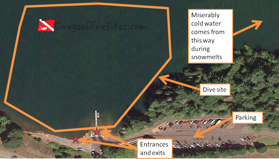
Park by the old boat ramp next to the big metal electrical transmission tower.

Imagery ©2017 Google, Map data ©2017 Google. The dive site accessible from the old boat ramp at the top end of Big Cliff Reservoir has some interesting submerged cliffs to check out.

Site Orientation:

We suggest sticking along the north shore of Big Cliff Reservoir.  We haven’t explored much on the southern shore so we can’t provide many details about it.  Sticking to the north shore also makes it much easier to get to an exit and back to your car.

We like to enter just upstream from the big metal electric transmission tower and drift down underwater.  Keep to the right and hug the cliffs at a depth that you want to stay at.  This dive site can go below the maximum recreational SCUBA depth.

Sometimes there is an eddy that will slowly push upstream right along the bank.  If the eddy is running, you can drift down with the current a little deeper and farther away from the bank, and then drift back up toward the exit closest to your car at a shallower depth.

There are potential underwater obstructions on this dive site.  It isn’t as bad, in our experience, as the upper riverbed dive site but the risk is still there.  There may also be potholes in the deep old riverbed that could have pinch points and caverns that could trap and drown you.  Be careful and dive within your personal limits!

Entrances and Exits:

We like to enter just above the electrical transmission tower and float down to the main part of the dive site.  The old boat ramp is another place to enter.  The last time we were here, the boat ramp was blocked off for boat traffic but you could still walk down to the water easily.  This boat ramp could reopen in the future or be more closed off than before.

The old boat ramp is also a good place to exit if your dive takes you back to this point.  Otherwise, there are a few places along the northern shore where you can exit and scramble up the bank to the road.  The scramble is difficult.

Salt/Fresh:

This is a fresh water dive.

Shore/Boat:

This is a shore dive although a boat could help if you want to drift much farther down the reservoir.

Normal Conditions:

There is always a strong current here.  Underwater obstructions and hazards are probably present.  Be careful and dive within your personal limits.  You could get hung up underwater and drown, and be very dead.

Normal Visibility:

Usually we get around 10 feet of visibility here.

Normal Temperature:

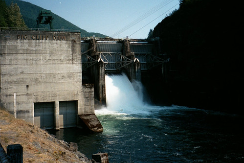
Water temperature varies based on what Detroit Dam is doing.  It can be down around 38F or up to about 65F depending on the time of year and upstream conditions.

Best Time of Year:

We have only gone diving here in the winter and spring.  It was fine during those times.  The rest of the year is also probably fine although in the summer and fall, there may be worse visibility due to poor water conditions.

Max Depth:

You can surpass 130 feet at this site if you try.  Be mindful of your depth and plan your dive.

Suggested Special Training:

We suggest rescue diver training and drift diver training for this site.

Difficulty of Dive:

The old boat ramp at Big Cliff is an intermediate level of difficulty dive site.  The main challenges are the current and potential surface swim or scramble up the bank, and the potential for underwater obstructions to catch and drown you.

Distance of Walk to Entrance:

100 feet or less.  But coming back from the lower exit is about a 600 foot walk.

Surface Swim Length:

Depending on how well you navigate and what the current is doing, none up to 600 or so feet to get to an exit.

Special Site Notes:

As we have already mentioned several times, this site has the potential for underwater obstructions of various types that could catch a diver and drown you until you are completely dead.  The current can be tricky here and we treat this site as a drift dive.

We suggest taking a good dive light so you can see your gauges and see where you are going.  When you get deep here, it becomes very dark.  We have several dive lights that we trust and use all the time when we go diving in Oregon that we list over on our Gear We Use page.

Closest Local Dive Shops to Get Air Fills and SCUBA Gear:

The closest dive shop is in Salem.

Nearby Restaurants We Like:

Up in the town of Detroit, there are several decent restaurants.  Let us know if you have a favorite that we should check out.

Nearby Places to Camp and Diver-Friendly Hotels:

There are many state and federal campgrounds in the area as well as a few private campgrounds.  Check at the USFS ranger station in Detroit for primitive camping options on the forest roads.

We haven’t tried any of the hotels or cabin rentals in the area yet.  Please get in touch with us if you know of a place that is SCUBA diver friendly!

What Other People Have to Say About This Site:

Please write in the comments below your experiences with this dive site!

Categories
Central Cascades

Big Cliff Reservoir – Upper River Bottom

The upper river bottom of Big Cliff Reservoir just below Detroit Dam on the Santiam River in the central Oregon Cascades is a serious business, no screwing around SCUBA diving site.  Don’t get us wrong, this is a fun site to drift dive, but it is also a very demanding site where you can easily get caught in an underwater obstruction and drown.  For this reason, this is a site that you need to be prepared to dive and be willing to accept the risks of the site.

Site Highlights

The main highlight of this site is doing a high speed drift dive down the river bottom.  There aren’t many places that are deep enough to blast down a river at breakneck speed.  Dodging sunken trees and huge boulders is great fun (although quite dangerous).  There are some deep potholes that you will most likely get sucked into and spit out the other side after swirling around inside a few times.  We don’t know if there are any underwater caves or pinch points that you might get stuck in but we would not be surprised if there are.  This site has some significant risks that you need to be aware of and willing to accept.

Nearest Town:

Detroit, Oregon is up the road from Big Cliff at the top end of Detroit Lake.

GPS Coordinates:

44.730873, -122.262835

Special Directions to Site:

Heading east on North Santiam highway, look for the right turn toward the top end of Big Cliff Reservoir.  The last time we went diving here a couple years ago, there was a sign for Detroit Dam but this may have been removed since then.

Parking:

We park at the old boat ramp next to the big metal electrical transmission tower.  There is another parking area up toward Detroit Dam on the access road that we have used to stage gear before leaving the car at the lower exit.

big cliff site plan
Imagery ©2017 Google, Map data ©2017 Google. The upper river at Big Cliff Reservoir is an exhilarating dive site but it can kill you.

Site Orientation:

You just follow the river down.  There isn’t much else to it.  Along the way you will encounter rocks, logs, big washtubs and potholes in the rock, and a bunch of other stuff that blazes by in the blink of an eye.

Entrances and Exits:

We usually enter at the entrance farthest up the river just above the bridge.  However, due to national security concerns, this area may now be closed off or could be closed off at any point in time.

There is another good place to enter and a good place to exit early just below the bridge at a pull-out.  If push comes to shove, you can exit just about anywhere along the river if you don’t mind scrambling up a steep bank.  You can also float along the surface until you reach the lower exit and your car.

The lower exit is at the old boat ramp and the big metal electrical transmission tower.  We have tried putting out a line underwater here so that we know when we need to surface but we seem to never manage to see the line.  Instead, watch your depth and surface when you hit around 50 feet (this depends on the Big Cliff Reservoir water level though).  If you blow past 50 feet, you’ll be heading into the lower dive site on Big Cliff Reservoir.

Salt/Fresh:

This is a fresh water dive.

Shore/Boat:

This is a shore dive.

Normal Conditions:

The whole point of this site is the incredible current.  You cannot fight against it.  All you can do is follow along.

The potential for underwater obstructions that can entangle and drown you is very real at this site.  Be darn sure of your skills and ready to accept the very real risks before you jump in here.  We are very skilled divers with experience diving all over the world and thousands of dives under our collective belts, and this site scares us.

You will almost certainly lose your buddy underwater unless you’re holding onto each other.  Be prepared and have a plan for what to do when you separate.  Taking the time to surface (which you should do unless you are certified to solo dive) will eat up a lot of river distance due to how fast the current is.

Water conditions change rapidly and drastically here based on what Detroit Dam is doing.  There is no warning for changing water conditions.  Although if you hear a big alarm klaxon, that may mean Detroit Dam is suffering some sort of breach or failure and you’re about to be swept way downriver in a flood.  That probably isn’t going to happen while you’re diving here though.

Normal Visibility:

We usually get 5-10 feet of visibility here.  It is dependent on the water quality exiting Detroit Dam upstream.

Normal Temperature:

Water temperature really varies here based on what Detroit Dam is doing.  Usually it seems the water is between 45 and 65F.

Best Time of Year:

We don’t know if there is a better time to dive here or not.  We have only gone to this site a couple of times in the spring and summer.  During those times, conditions were acceptable for the level of risk we were willing to take.

Max Depth:

Most of the way along the river, you will be between 15 and 25 feet deep.  In potholes, you can hit 40 feet briefly.  At the bottom end of the site, you should surface before you hit 50 feet so that you don’t end up way down at the bottom of Detroit Lake.

Suggested Special Training:

Anything less than a rescue diver certification and extensive experience with drift diving and underwater hazards is really asking for trouble at this site.  Even with that training and experience, this site is still risky.

Difficulty of Dive:

If it weren’t for the very real danger of being pinned under a log or against a rock where you will slowly run out of air and then drown, this would be a fairly straight forward and easy dive.  Because of these very real risks, you need to be in peak physical condition and be a very experienced diver.

Distance of Walk to Entrance:

Depending on where you park, if you drop your gear off upriver, and if you choose to enter at the middle or upper entrance, you could be walking anywhere from 50 feet to 2400 feet.

Surface Swim Length:

There is no surface swim here.  Swimming against the current is normally impossible.

Special Site Notes:

This is a no screwing around dive site.  There are many things underwater waiting and eager to grab and drown you thoroughly dead.  Get some serious training and serious experience before you attempt this site.

We suggest taking a good dive light so that you can at least read your gauges in some of the deep, black holes.  We have several dive lights that we use every time we dive in Oregon and highly recommend at the Gear We Use page.

[Underwater Map of Dive Site Coming Soon!]

Closest Local Dive Shops to Get Air Fills and SCUBA Gear:

There aren’t any close dive shops up here.  The closest shop is in Salem.

Nearby Restaurants We Like:

Detroit has a few small restaurants that are decent places for a meal.

Nearby Places to Camp and Diver-Friendly Hotels:

There are several federal and state campgrounds nearby and plenty of primitive camping in the national forest.

We haven’t tried any of the hotels or cabins in the area.  Please let us know if you know of a good place that is SCUBA friendly!

What Other People Have to Say About This Site:

Please write in the comments below your experiences with this dive site!

Categories
Central Cascades

Foster Reservoir – Calkins Park

Calkins Park on the top end of Foster Reservoir is a decent place to do training dives or to explore for things that fall overboard from boats being put into the water at the boat ramp.  We have done some training dives here for a rescue diver class.  The dives were pretty miserable but it was excellent training for all of the students.  If you’re looking for a site to dive in the central Oregon Cascades, this could be just the ticket.

Foster Reservoir (Linn County, Oregon scenic images) (linnDA0050a)
Gary Halvorson, Oregon State Archives [Attribution], via Wikimedia Commons. Calkins Park can be beautiful in the summer and fall but can be a wet, miserable place in the winter and spring.

Site Highlights:

You can probably already tell that this isn’t our favorite dive site.  The bottom is muddy and will cause complete blackout conditions if you touch it.  In the winter and spring when snowmelt is pumping down into the reservoir, the water can be right at freezing.  In the summer and fall, boaters crowd the boat ramp and make this site not very safe for SCUBA divers.

That being said, Calkins Park is a great place to go train in sometimes challenging conditions.  We have participated in and seen several rescue diver classes take place here.  The conditions are demanding and the site is challenging enough to be useful for training but not so challenging as to be bad for teaching a class.

If you go to dive here for fun, more power to you.  You might find a lost wallet or fishing gear that fell off of a boat getting put into the water.

On one particular day, we did several training dives at this site.  The water temperature was cold enough that we were quite unhappy with our drysuits because they weren’t keeping us particularly warm.  We could see ice crystals flowing by in the water.  The bottom conditions instantly turned into blackout at the slightest fin touch.  The current was strong and unrelenting.  One student dropped his face mask and it instantly vanished in five feet of water.  No amount of scouring the bottom revealed where the mask had gone.  But the students learned a lot and are much better divers for the experience.

Nearest Town:

Sweethome, Oregon is just down the road.

GPS Coordinates:

44.413542, -122.626049

Special Directions to Site:

Head east from Sweethome on US 20 (Santiam Highway) and look for signs to Calkins Park and Quartzville Road.  Right after you turn left onto Quartzville Road, take another left into Calkins Park.

Parking:

We went diving here in the late winter and had the place to ourselves.  In the summer and fall, parking is packed.

calkins par
Imagery ©2017 Google, Map data ©2017 Google. Calkins Park is a good place for training dives in challenging conditions but otherwise is not something that we dive regularly.

Site Orientation:

The shore runs more or less east west.  Deeper water is to the north.  Steer clear of the boat ramp when people are actively loading and unloading boats.  We suggest taking a dive flag along if there are boaters in the area.  We have a dive flag that we love and use listed on our Gear We Use page.

Entrances and Exits:

If there isn’t any boat traffic, you can use the boat ramp.  Otherwise, the beach to the west of the boat ramp is usually a good entrance even when the water is very low.

Salt/Fresh:

This is a fresh water dive.

Shore/Boat:

This is a shore dive although you could practice boat diving here.

Normal Conditions:

Conditions vary widely based on the time of year and water level in the reservoir.  In the summer and fall, there is very little current and the site gets a bit stagnant from the water not moving.  In the winter, icebergs can flow into the lake with the water level so low that the site is not diveable.

Normal Visibility:

The best we have ever seen here is about five feet of viz.  If you even so much as look at the bottom the wrong way, you will have instant blackout conditions that will not clear if there isn’t enough current.

Normal Temperature:

32F during snowmelt all the way up to 65F at the end of a hot, dry summer.

Best Time of Year:

There isn’t any boat traffic here in the winter which is desirable.  Otherwise this site can be dived any time that the water is high enough and you are bold enough to do so.

Max Depth:

The max depth really varies based on how much water is in the reservoir.  When we went diving here in the winter, we never went below 30 feet but in the summer when the reservoir is full, you could see 60-70 foot depths.

Suggested Special Training:

Open water divers can dive this site.  It would be a good place to practice your neutral buoyancy skills and navigation.

Difficulty of Dive:

This is an easy dive with an easy entrance.  The only difficulty is when the water is freezing cold and when you get blackout conditions because you stir up the silt.

Distance of Walk to Entrance:

Depending on parking and water level, 50-500 feet.

Surface Swim Length:

No surface swim is needed usually.

Special Site Notes:

Ask yourself if you really want to dive here before you bother setting up your gear.  We think this is a pretty miserable dive site in the winter and spring.  In the summer and fall there is a lot of boat traffic.  The bottom stirs up and reduces visibility to absolutely nil.

When the water level is low, the lake bed becomes a series of morasses and mud flats where people sometimes get stuck up to their waists in the mud.  Go gingerly through the mud and turn back if you start to hit quicksand.

[Underwater Map of Dive Site Coming Soon!]

Closest Local Dive Shops to Get Air Fills and SCUBA Gear:

There isn’t any dive shop around Calkins Park.  The closest shops are in Salem and Eugene.

Nearby Restaurants We Like:

Sweethome has a couple decent restaurants.  Let us know if you have a favorite that we should try!

Nearby Places to Camp and Diver-Friendly Hotels:

There is plenty of camping in the area at federal campgrounds, private campgrounds, and off forest roads where you can do primitive camping.  We haven’t tried any hotels or cabins in the area.  Let us know if you know of a good hotel that is SCUBA diver friendly in the area!

What Other People Have to Say About This Site:

Please write in the comments below your experiences with this dive site!