Categories
Northern Oregon Coast

Hammond Boat Basin North Jetty

The Hammond Boat Basin North Jetty is exposed to the ripping current of the Columbia River main channel but if you dive at slack tide, you can get halfway decent water conditions and a unique experience.  Old ruins on the north end of the dive site usually have good marine life although there is the potential for entanglement hazards.  Head away from land a few feet and you will find the water gets rapidly deeper as you approach the shipping channel.

Imagery ©2017 Google, Map data ©2017 Google.
The Hammond Boat Basin North Jetty is exposed to the ripping current through the main channel of the Columbia River as it rushes the last few miles to the ocean. Old ruins are interesting to check out although there are entanglement hazards.

Nearest Town:

The dive site at the Hammond Boat Basin North Jetty is just north of downtown Hammond, Oregon

GPS Coordinates:

46.206129, -123.951349

Special Directions to Site:

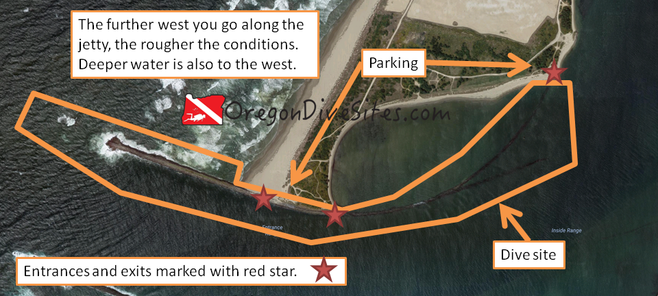
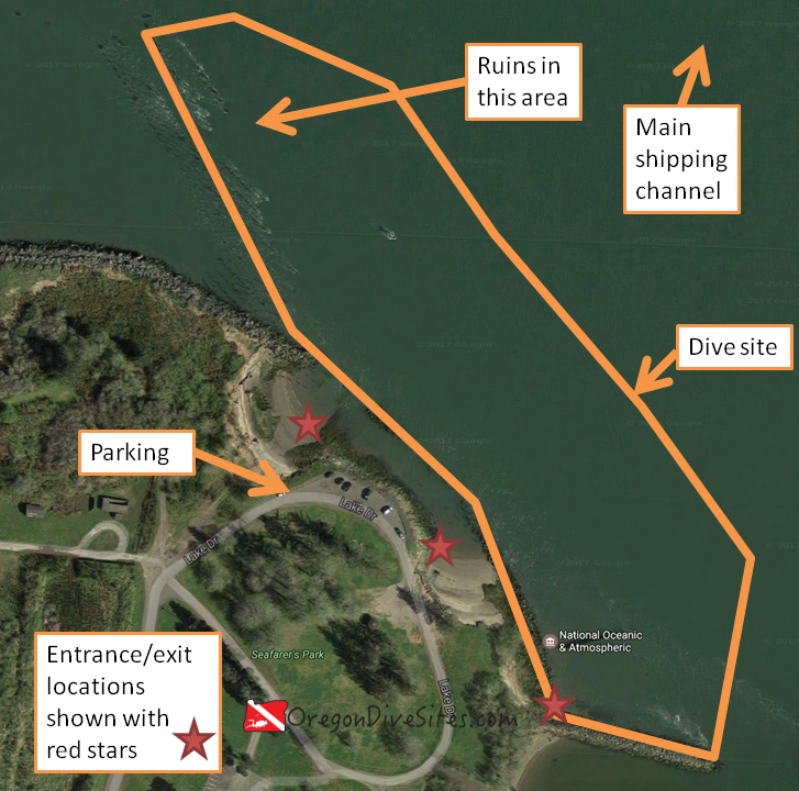
Head north from downtown Hammond toward the boat basin.  Follow signs for Seafarer’s Park.

Parking:

There is parking at the north end of Seafarer’s Park.  The last time we checked, parking was free although this could change.  Be sure to verify with the signs in the park.


Site Orientation:

The dive site sticks along the jetty from the entrance to Hammond Boat Basin at the south and east end of the dive site up to the ruins at the north and west side of the dive site.  If you head north and east, you will eventually run into the Columbia River shipping channel.  It’s a good idea to stick closer to land where you have at least a little protection from the current.

Entrances and Exits:

There are several decent entrances and exits along the jetty near the parking area.  We marked several on the map above but if you look around a little at the Hammond Boat Basin North Jetty, you will find a few other decent places to climb over the jetty rocks and enter the water.

Salt/Fresh:

This is a salt water dive.

Shore/Boat:

This is a shore dive.

Normal Conditions:

There can be a lot of current at this site.  Be sure to dive at slack tide.  SCUBA diving here during the tidal exchange could cause you to have a rather unpleasant drift dive.  There is regular boat traffic in the area both in the main shipping channel and coming into and out of the Hammond Boat Basin.  It’s a good idea to fly a dive flag.

Normal Visibility:

Depending on river conditions, you might get only 3 feet of viz or up to 15 feet of viz.  Be prepared for low visibility conditions.

Normal Temperature:

Temperatures can vary between 45 and 55F depending on the time of year.

Best Time of Year:

There doesn’t seem to be one best time of year here.  In the summer the parking lot can be full on the weekends.

Max Depth:

You can find 50+ feet of water if you head toward the main shipping channel.  Right along the jetty, the water is shallow (max 15 feet).

Suggested Special Training:

Advanced open water training is a good idea to dive the Hammond Boat Basin North Jetty.  Experience with diving in a high current area is also a good idea.

Difficulty of Dive:

We rate this as an intermediate dive because of the current and the risk of entanglement in the old ruins on the north end of the dive site.

Distance of Walk to Entrance:

Depending on where you enter, you might need to walk up to 200 feet.  At the entrances near the parking lot, you may need to wade through water before it gets deep enough to swim in.

Surface Swim Length:

No surface swim is needed here.

Closest Local Dive Shops to Get Air Fills and SCUBA Gear:

The dive shop in Astoria is full service and has an air fill station.

Nearby Restaurants We Like:

There is decent food in Hammond and great food over in Astoria.

Nearby Places to Camp and Diver-Friendly Hotels:

There are a lot of public campgrounds in the area with good camping.  We haven’t tried any of the local hotels so please let us know if you’ve found one that is SCUBA diver friendly.

What Other People Have to Say About This Site:

Please write in the comments below your experiences with this dive site!

Categories
Southern Oregon Coast

Gold Beach North Jetty

The Gold Beach north jetty is a shallow dive site that often has some surf and surge especially on the outer part of the dive site.  SCUBA divers can expect to find good crabbing and spearfishing here.  Another potentially interesting thing to do at this dive site is to search for gold nuggets.  There is a reason that Gold Beach has its name.  Back when white settlers first came to the area, gold was found in the black sand beaches around the mouth of the Rogue River.  Most of it was long ago mined and carted off but there still is a little color now and then in the sand.

Imagery ©2017 Google, Map data ©2017 Google.
The Gold Beach north jetty at the mouth of the Rogue River is a shallow dive site that often has surf and surge but there is good crabbing and spearfishing here.


Nearest Town:

This Oregon SCUBA diving site is in the middle of Gold Beach, Oregon.

GPS Coordinates:

42.423749, -124.428970

Special Directions to Site:

Turn onto Wedderburn Loop from US101.  You’ll see the jetty just to the south of the road.  Follow the gravel road west along the jetty.

Parking:

There are many places to park along the Gold Beach north jetty.  Choose your entrance and park near it.  Be sure to not block the jetty road.  The last time we checked, the parking was free.  Verify though when you visit this dive site.


Site Orientation:

The jetty runs southwest away from land.  The inside of the jetty is usually much calmer than the outside but both the inside and outside can get rough sea conditions.  You will see a big sand bar in the middle of the river mouth.  This bar really makes conditions shallow at Gold Beach.  Stick in the river channel along the north jetty for the deepest water you can find at this site.  Don’t expect to be amazed with a really deep dive site.  This is a very shallow place to go diving.

Entrances and Exits:

You can clamber over the jetty wall anywhere along its length.  In the map above, we marked a few good entrances and exits on the Gold Beach north jetty.

Salt/Fresh:

This is a salt water dive.

Shore/Boat:

This is a shore dive.

Normal Conditions:

You will almost certainly encounter current on the Gold Beach north jetty.  SCUBA divers can expect to find some surf and surge as well, especially further west along the jetty.

Normal Visibility:

Depending on ocean and river conditions, you might get 5 feet of viz or up to 20 feet of viz.  Plan on lower visibility and maybe you’ll get surprised with good viz.

Normal Temperature:

Water temperature is usually between 45 and 57F here.

Best Time of Year:

This site is diveable any time of the year assuming there isn’t a big storm in the ocean.

Max Depth:

You will be hard pressed to find more than 30 feet of water at high tide at the jetty tip at this site.  If the US Army Corps of Engineers starts more aggressively dredging the Rogue River bar and channel, this site might get deeper but we wouldn’t count on that happening anytime soon.

Suggested Special Training:

Open water divers with a few jetty dives under their belt can dive this site.

Difficulty of Dive:

We rate this as an intermediate site because of the current and the surf and surge conditions.

Distance of Walk to Entrance:

Depending on where you park, you might have a 50 foot or a 500 foot walk.  Park closer for less walking.

Surface Swim Length:

No surface swim is needed at the Gold Beach north jetty.

Special Site Notes:

We’re not kidding when we say that the water isn’t very deep here and that there can be a lot of current.  While the Rogue River bar might have been dredged to be deep and wide many years ago, nowadays the channel is narrow and shallow.

You’re going to want a dive flag here because of the pleasure boat traffic.  And be very careful as you surface that you don’t end up with a propeller blade through the top of your skull.

Closest Local Dive Shops to Get Air Fills and SCUBA Gear:

Go south to Crescent City or go inland to Grants Pass or Medford for full service dive shops.  Port Orford has an air fill station.

Nearby Restaurants We Like:

There are a few decent restaurants in Gold Beach.  Let us know if there is one you particularly love.

Nearby Places to Camp and Diver-Friendly Hotels:

We haven’t stayed in any of the hotels around Gold Beach but we can report that there are many campgrounds and primitive camping opportunities in the area.

What Other People Have to Say About This Site:

Please write in the comments below your experiences with this dive site!

Categories
Southern Cascades, Siskiyous, and Around Klamath Falls

Copper Boat Ramp at Applegate Lake

The Copper Boat Ramp on Applegate Lake is a good place to get wet in the Siskiyou mountains in Southern Oregon. It is one of several boat ramps with good access for SCUBA divers along Applegate Lake.  This being a fresh water reservoir, you will see the standard stuff we expect in Oregon’s man-made lakes such as trout, bass, and other fish; old tree stumps; and the occasional lost fishing rod.  Around the boat ramp you’re more likely to find things dropped by boaters.

Applegate Reservoir
Applegate Lake is an excellent place to do some diving in Southern Oregon.


Nearest Town:

The little town of Ruch is the first place of any size that you will find heading downriver from the lake.  Medford and Grants Pass are just a little further away.

GPS Coordinates:

42.028558, -123.148729

Special Directions to Site:

Once you pass the dam on Upper Applegate Road, keep heading south until you see signs for the Copper Boat Ramp.

Parking:

There is parking near the boat ramp.  Don’t take up spaces for trailers unless you have a trailer.  When we visited last, there was no fee to park but that could change in the future.

applegate lake copper boat ramp
Imagery ©2017 Google, Map data ©2017 Google.
The Copper Boat Ramp on Applegate Lake in the Siskiyous is a good place to get wet in Southern Oregon.

Site Orientation:

The dive site is the flooded canyon of the Applegate River.  The land you want to come back to is to the west.  Deeper water is to the east.  If you start going uphill headed east, you’ve passed the deepest part of the dive site and are heading toward the opposite bank.

Entrances and Exits:

There are a lot of easy entrances/exits here depending on what you want to do.  If you want the easiest entry, just walk on in near the car parking area or over the boat ramp.

Salt/Fresh:

Copper Boat Ramp is a fresh water dive.

Shore/Boat:

This is a shore dive.

Normal Conditions:

In the late summer or early fall the water can get a little stagnant if there hasn’t been rain for a long time and if it was a bad snow year the previous winter.  In the winter, the lake can be drawn very low prepping for spring rains.

Normal Visibility:

Normally you’ll get 10-15 feet of viz here although the bottom can be stirred up so be sure to steer clear of it.

Normal Temperature:

In the early spring when snow melt is pumping into the reservoir, you might find water in the 37F range.  Late in the summer, the Copper Boat Ramp can get a thermocline with temperatures in the upper 60s near the surface and in the low 50s at depth.

Best Time of Year:

This site is good during the summer and sometimes in the fall, depending on lake water levels.

Max Depth:

When the reservoir is full, you can hit around 80-90 feet at this site in the deeper section beyond where we drew the site boundary.

Suggested Special Training:

This is an altitude dive.  You should have altitude diver training to dive this lake.  Open water divers with altitude training can successfully dive this site.

Difficulty of Dive:

We believe this site is suitable for freshly certified open water divers with altitude specialty training.

Distance of Walk to Entrance:

Depending on where you park and lake levels, you might walk 50 feet or 500 feet to your entrance/exit.

Surface Swim Length:

No surface swim is needed.

Special Site Notes:

There is a lot of boat traffic at the Copper Boat Ramp and in Applegate Lake during boating season (summer and fall).  Be sure to fly a dive flag.  We have one we use when we go diving in Oregon.

Closest Local Dive Shops to Get Air Fills and SCUBA Gear:

There are SCUBA shops in Grants Pass and Medford as well as over in Klamath Falls.

Nearby Restaurants We Like:

Jacksonville has some good food.  We haven’t tried any of the closer options so please let us know if you have a favorite place to eat.

Nearby Places to Camp and Diver-Friendly Hotels:

There is a lot of primitive camping and there are a few campgrounds in the area.  We haven’t found a diver-friendly hotel between Ashland and Grants Pass yet.  Please let us know if you know of one that will welcome SCUBA divers and their wet gear.

What Other People Have to Say About This Site:

Please write in the comments below your experiences with this dive site!

Categories
Southern Oregon Coast

Port Orford Jetty and Graveyard Point

Anyone who has been to the Oregon Coast Aquarium knows that there is something special about Port Orford and the Orford Reef.  They have an entire exhibit named after it, after all (and it’s diveable!).  While most of the best diving around Port Orford is offshore and requires a boat to access, the Port Orford jetty and Graveyard Point is diveable from shore.  Recreational SCUBA divers who don’t mind making the drive to Port Orford are rewarded with excellent diving and marine life all within steps of an air fill station at the port office (as of the last time we checked), good food right in the harbor, and a good story to tell.  Port Orford is one of the few ports in the USA where ships are raised out of the water when they come into port.

Depending on the weather, the inside part of the dive site might be the better bet.  The western outside area is more exposed to the Pacific Ocean.  The area along the dock should only be entered after obtaining permission from the port authorities.  If a vessel is being raised out of or lowered into the water, or a boat is being unloaded of her catch, you shouldn’t try diving the dock.


port orford jetty and graveyard point
Imagery ©2017 Google, Map data ©2017 Google.
The Port Orford jetty and Graveyard Point is a good place to go diving from the shore right in the middle of some of the best diving in Oregon.

Nearest Town:

You’re right in the middle of Port Orford, Oregon when you’re diving on the jetty and Graveyard Point.

GPS Coordinates:

42.738692, -124.498685


Special Directions to Site:

From US101, head south on Harbor Drive.  Harbor Drive turns into Dock Road.  Head down the hill.  Drive out through the marina until you see the parking area on the west side.

Parking:


The last time we were here, parking was free and plentiful.  Double-check when you arrive to make sure this is still the case and that you’re parking in the correct area.

Site Orientation:

This site wraps around Graveyard Point and the port jetty.  The western side of the site is more exposed to the ocean so conditions can be rougher.  Only attempt the western side in favorable conditions so that you don’t get dashed on the rocks.  The eastern side of the site is more protected and usually has calmer water.  Only enter the dock area if you have pre-arranged permission from the port authority and no ships are present.

Entrances and Exits:

There are several places to enter and exit depending on what part of the site you’re diving.

Along the dock wall there are several ladders that go down to the water.  Ask for permission from the port authority before using them to make your entrance/exit.

At the southern end of the parking lot, you can scramble down on the east side of the jetty to make an entrance.  This is a fairly lengthy scramble.  Make sure to scout out your route before you slog down to the water.  You can also enter on the west side of the jetty.  Watch conditions before you try to make your entrance here.

Further up along the parking area, there is a cement culvert that runs down to the water.  Follow the culvert down over the rocks and you will find a halfway decent entrance/exit although the drop to the water can sometimes be a little much if the tide isn’t very high.

Salt/Fresh:

This is a salt water dive.

Shore/Boat:

This is a shore dive.

Normal Conditions:

It is common to have surf, surge, and current especially on the west side of this dive site.  The east side is usually calmer and often can be dived when the west side is too rough.

Normal Visibility:

Depending on what the ocean is doing, visibility will be between 5 and 30 feet.  Usually you’ll have a solid 15-20 feet of viz on the west side of Graveyard Point.  On the east side of Graveyard Point, you often get more like 10-15 feet.

Normal Temperature:

This is all ocean water with no fresh water runoff to modify temperatures.  Expect between 48F and 58F depending on the time of year.

Best Time of Year:

There is no best time of year here.  The biggest thing is to watch ocean conditions and plan your dive around calmer weather.

Max Depth:

You’ll find about 35 feet of water at the deepest point along the west side of Graveyard Point.  The tip of the jetty is about 25 feet deep.

Suggested Special Training:

Divers with a few jetty entries under their belts should be okay here.  However, conditions can rapidly deteriorate especially on the west side of the dive site.  Advanced training and a solid backup plan are good ideas here.

Difficulty of Dive:

We rate this as an intermediate dive although conditions can rapidly deteriorate, especially on the west side, and make this an advanced or even an impossible dive.  Don’t end up dashed upon the rocks like so many ships have done over the decades!

Distance of Walk to Entrance:

Depending on where you park and where you enter, you will walk as little as 100 feet or as much as 1000 feet.

Surface Swim Length:

The only reason for a surface swim here is if you get caught on the outside of Graveyard Point and need to make a swim inside the jetty to exit.  It would be better to be underwater for that swim but realistically you’ll probably be coming up after a fun dive and realize that you don’t have enough air to make the trek to the other side.

Special Site Notes:

The port authorities are all nice people and it’s worth it to chat them up.  One of them has a wealth of knowledge about other SCUBA sites in the area.

Closest Local Dive Shops to Get Air Fills and SCUBA Gear:

As of the last time we checked, there is an air fill station at the port.  You might need to call ahead to make sure someone is there to fill your tanks.  Full service SCUBA shops are located inland (Grants Pass, Roseburg, Eugene) or down south (Crescent City).

Nearby Restaurants We Like:

The restaurant on the dock is a good place to eat and a lot of fun.  Otherwise, there are many other good places to eat up in town.

Nearby Places to Camp and Diver-Friendly Hotels:

We haven’t stayed overnight at Port Orford but there are a number of campgrounds in the area.  Let us know if you have a favorite campground or hotel that is SCUBA diver friendly!

What Other People Have to Say About This Site:

Please write in the comments below your experiences with this dive site!

Categories
Southeast Oregon

Antelope Reservoir

If you’re looking for a remote dive site on the edge of the Oregon high desert, then Antelope Reservoir might be exactly what you’re looking for.  This dive site won’t win any awards for having interesting stuff to see underwater or for being deep (at its max depth, the reservoir is 25 feet deep!).  The water is not very clear and is stagnant in the summer.  There are a few trout in the lake but otherwise there isn’t much going on here.

So why would you bother going all the way out to the Jordan Valley by Jean Baptiste Charbonneau’s grave to do some SCUBA diving?  Good question!  The only real draw for this site is that it’s a little bit of water in a great big desert where you can do a little SCUBA diving to check it off the list of places to go diving in Oregon.

antelope reservoir
Imagery ©2017 Google, Map data ©2017 Google.
Antelope Reservoir is way out in the Jordan Valley on the eastern fringe of Oregon. You can’t get much farther away from the ocean in the Beaver State. The dive site is pretty boring but that’s not really the point of diving here. The reason you would haul all your gear out here is because this dive site is in the middle of the desert. Why not check out a dive site off the beaten path?


Nearest Town:

GPS Coordinates:

42.909122, -117.236012

Special Directions to Site:

From the Ion Highway, look for signs for Antelope Reservoir.  The road is called Antelope Reservoir Road although sometimes the road sign is missing.  Head up the hill until you see the lake.  The parking area is just north of the dam.

Parking:

The last time we were here, the parking was free.  There are four free campsites here, too.


Site Orientation:

Let’s get this out of the way: this is a lousy dive site.  We wouldn’t bother coming out here to do a dive except for the novelty of diving in the middle of the Oregon high desert.  The reservoir is shallow and often has less than ideal water conditions.  The drive is very long from any major population centers.  There really isn’t anything to see under the lake.

If you go to dive this site, we suggest going out and doing some compass skills (trench patterns, box patterns, etc.) to give you something to do.  Who knows?  You might find an abandoned sunken car or a lost fishing rod.

The main thing to watch out for here is getting too close to the water intake structure on the dam.  You don’t want to get sucked through and end up downstream in small pieces.

Entrances and Exits:

Just walk down the boat ramp until you get to the water.

Salt/Fresh:

This is a fresh water dive.

Shore/Boat:

This is a shore dive although you could bring a boat and do a little boat diving here, too.

Normal Conditions:

The lake can get a few waves from the wind occasionally.  In the winter, the lake ices over sometimes.  In the summer, the water gets very low as you get closer to the fall.

Normal Visibility:

You’ll be lucky to get 10 feet of viz here.  The bottom can be stirred up so stay clear of it.

Normal Temperature:

During spring snow melt, the water temperature will be near freezing.  At the end of a long hot summer, water temps can be up in the 60s although usually will be in the 50s.

Best Time of Year:

Late spring or early summer is the best time of year to dive this site.  Later in the summer and fall, the water level will be very low and the water will get nasty from being stagnant all summer.  In the winter, this is usually a bitterly cold place to be.

Max Depth:

If the reservoir is completely full and you really search for it, you will be able to hit 25 feet.  Expect more in the neighborhood of 15 feet.

Suggested Special Training:

This is an altitude dive.  The lake is at about 4300 feet.  Plan accordingly.

Difficulty of Dive:

We rate this as an intermediate dive because of needing altitude training to dive this site.

Distance of Walk to Entrance:

Depending on the water level, you might need to walk several hundred feet.

Surface Swim Length:

You’ll want to kick away from shore at least 200 feet to get a little depth in the water column.

Special Site Notes:

Avoid the water intake structure on the dam.  Don’t become fish food!

There are other potential places to explore on Antelope Reservoir although we don’t know why you would spend the time and resources to do so.  Take a quick dip at the boat ramp and check this site off your list of Southeast Oregon SCUBA diving sites.

Closest Local Dive Shops to Get Air Fills and SCUBA Gear:

The closest place for any sort of services is in Boise, Idaho a few hours away.  This is a very remote site.  The last time we were here, there was very patchy cellphone service.  You need to be fully self-sufficient.

Nearby Restaurants We Like:

There might still be a restaurant in Jordan Valley, Oregon.  Otherwise you have several hours to go to find any sort of services or food.

Nearby Places to Camp and Diver-Friendly Hotels:

There are a couple free campsites right at the boat ramp.  Otherwise there is a LOT of BLM land out in Southeast Oregon where you can camp for free.  We don’t know of any hotels nearby.

What Other People Have to Say About This Site:

Please write in the comments below your experiences with this dive site!

Categories
Southern Oregon Coast

Zwag Island and Diver Rock / Mill Beach

Mill Beach, located between Zwagg Island and Diver Rock on one side and Chetco Point on the other, is a good place to do a surf entry dive in Brookings, Oregon.  The scattered kelp makes for a fun area to play and explore, and the rocky cliffs and underwater mounts are a good place to go spearfishing.  If you have a boat, the outer kelp forest is easily accessible.  Otherwise, a surf-launched kayak SCUBA diving platform would be pretty useful to get further out on this dive site.


Imagery ©2017 Google, Map data ©2017 Google.
After a surf entry from Mill Beach, the small cove between Zwag Island and Chetco Point is a good place to play in some kelp. If you have a boat or a shore-launched kaya dive platform, some of the farther out rocks are worth the trip for spearfishing or crabbing.


Nearest Town:

The road down to the parking area for Mill Beach goes right through Brookings, Oregon.

GPS Coordinates:

42.048907, -124.292677


Special Directions to Site:

Accessing the site is a little challenging.  The way we know to get to the little hidden parking lot is as follows: From US101 turn onto Mill Beach Road.  You’ll go behind Fred Meyer, past the old mill site, and then it gets a little tricky.  Look for Macklyn Cove Drive taking off to the left and turn onto it.  You’ve gone too far on Mill Beach Road if you end up in a cul de sac.  On Macklyn Cove Drive, look for a left turn driveway.  If you end up in front of an apartment complex, you went too far.  At the end of the driveway there is a very small parking lot.

Parking:

The last time we were here, parking was free but very limited.  Be sure to check the signs and be sure to not block anyone in.  If it’s a popular weekend for SCUBA diving, it’s a good idea to show up a few hours before the tide to snag a parking space.


Site Orientation:

The site is centered around Macklyn Cove and anchored between Zwagg Island and Diver Rock on one side, and Chetco Point on the other.  Table Rock is in the middle of the beach.  navigation here is a little more complex than diving on jetties in Oregon.  You need to pay attention to where you are in the site.  The beach spans the north and north-northeast portions of the site.  This is where you do your surf entrance/exit.  If you’re on a boat, then be sure to know where you are in relation to your boat.

If you’re shore diving this site, generally we’d suggest you stick between Diver Rock and Chetco Point, and not go outside of the cove.  The swim is lengthy otherwise and there is plenty to see inside the cove.

The site is big enough that it takes 2-4 dives to cover the whole place unless you’re going on a speed tour.  There are plenty of wildlife viewing opportunities and we’ve seen people spearfishing here.

Entrances and Exits:

If you’re shore diving, you have a surf entrance to deal with.  Be sure you have surf entrance/exit training and it’s not a bad idea to practice the drills before you head out.  Down in California at Monastery Beach near Monterey, SCUBA divers die every few years because they panic during rough surf exits and drown within 20 feet of dry land.

If you’re boat diving, you will probably be anchoring at the southern or western edge of this dive site.  In that case, you’ll be dealing with a boat entry and exit.

Salt/Fresh:

This is a salt water dive.

Shore/Boat:

You can dive this site either from shore or from a boat.

Normal Conditions:

While the cove is fairly protected, you need to be ready to deal with surf, surge, and a little current.  If a storm is coming in, don’t bother with this site.  Be prepared to do an army crawl out of the surf if conditions deteriorate while you’re diving.  It’s not a bad idea to survey the whole beach when you surface to see if there is one area that is less rough than the rest of the beach.  We generally try to surface with plenty of reserve air in our tanks in case we have to army crawl on our bellies through the surf zone to safely exit.

Normal Visibility:

Depending on ocean conditions, you’ll have anywhere from almost no visibility up to 25+ feet of viz.  The further away from shore you go, generally the clearer it gets.

Normal Temperature:

Water temperature here can vary from 45F at the extreme cold end to 57 or 58F on the extreme hot end.

Best Time of Year:

You can dive Mill Beach almost any time of the year although storms and ocean conditions really dictate when you can dive here.

Max Depth:

At the deepest part of the site in the middle of the cove, you could find about 60 feet of water.  Along the edges, expect more in the 25-30 foot range.

Suggested Special Training:

Be sure you have surf entry and exit training.  Be sure you’re confident in your navigational skills.  Advanced open water training is a good idea here.

Difficulty of Dive:

We rate this as an intermediate dive as far as shore dives go but if conditions are bad, this can be a very advanced dive.

Distance of Walk to Entrance:

Assuming you can find parking in the parking lot, you’re looking at between 200 and 1000 feet of walking to get to a good place on the beach to enter.

Surface Swim Length:

You will want to kick out 200-300 feet to get beyond the surf zone and into deeper water before you descend.

Special Site Notes:

This site is exposed to the Pacific Ocean.  Especially as you get to the tips of the points of land jutting into the ocean, you will be exposed to whatever the ocean is doing that day.  Be sure you know how to dive in these conditions.

Closest Local Dive Shops to Get Air Fills and SCUBA Gear:

We aren’t aware of any reasonably close dive shops to this site.  There is an air fill station up in Depoe Bay and the Medford area has a dive shop but otherwise we haven’t found any nearby shops in Brookings or further south in California.  Let us know if you know of one.

Nearby Restaurants We Like:

We have never eaten in Brookings so we can’t comment on the restaurants.  Please let us know if you know of somewhere good to eat.

Nearby Places to Camp and Diver-Friendly Hotels:

We haven’t stayed in Brookings before.  Let us know if you know of a good campground or a SCUBA diver friendly hotel near Mill Beach.

What Other People Have to Say About This Site:

Please write in the comments below your experiences with this dive site!

Categories
Southern Oregon Coast

Bandon South Jetty

The Bandon south jetty is a good place to go crabbing or spearfishing on the southern Oregon coast.  SCUBA divers will find an abundance of marine life and a few other surprises, too.  However, the outer part of the jetty gets pounded by winter storms and when the wave sets line up right, you can get breakers all the way into the bay.  It’s a good idea to have a backup plan like one of the dive sites further up the bay or into the Coquille river.


Imagery ©2017 Google, Map data ©2017 Google.
As long as conditions are decent, the Bandon south jetty is a good place to go crabbing or spearfishing. In stormy weather though, it’s a good idea to stick inside the jetty where it is usually calmer.


Nearest Town:

The Bandon south jetty is just west of downtown Bandon.

GPS Coordinates:

43.122508, -124.428339

Special Directions to Site:

From downtown Bandon, head west.  The road curves to the left.  Turn right onto Jetty Road.  Jetty Road curves around to the north and becomes Lincoln Avenue.  Follow the road to the parking lot at the jetty.

Parking:

The last time we were here, parking was free and plentiful.  However, you may need to pay to park in the future so be sure to read the signs when you arrive.

Site Orientation:

The jetty structure runs roughly east-southeast to west-northwest.  The outer part of the jetty often has much rougher conditions than the inner part.  If you venture out to the jetty tip and around to the south side of the jetty, you will be full exposed to the Pacific Ocean.  On the inner part of the jetty, the jetty is often just below the surface of the water at high tide.  This area is often a little calmer and more protected.  The dive site ends by the restaurant.

There are some interesting underwater rocks just to the north of the jetty between the parking lot and about halfway to the restaurant.  They’re worth exploring.

Entrances and Exits:

The main entrance/exit is over the jetty wall at the parking lot.  If you head in toward Bandon, you can hop out at the restaurant on the far west end of downtown Bandon.  Although if you do that, you’ll have a long walk back to your car.  It’s much better to plan to exit where you entered.

Salt/Fresh:

This is a salt water dive.

Shore/Boat:

This is a shore dive.  There isn’t any room to have a boat wait for you while you dive.  Otherwise you’d block the shipping channel.

Normal Conditions:

You’ll almost certainly encounter current.  You’ll most likely encounter some surf, surge, and a few other nasty things that the ocean can throw at you if you venture out toward the Bandon south jetty tip.  Be cognizant of the weather and plan your dive accordingly.

Normal Visibility:

Usually the viz is around 15 feet although with big storms, the viz can go to practically zero.

Normal Temperature:

Water temp is usually in the 45-55F range although SCUBA divers can encounter colder water on the east end of the dive site when a big snow melt is happening in the coast range mountains.

Best Time of Year:

The site can be dived any time of the year.

Max Depth:

This is a shallower dive site.  You’ll max out at 25 feet deep if you bring a shovel and are on a very high tide.

Suggested Special Training:

Due to the rough conditions on the western part of the Bandon south jetty, it’s a good idea to have advanced open water training and experience with rougher water.

Difficulty of Dive:

We rate this as an intermediate dive due to the jetty scramble and the rough conditions on the western part of the Bandon south jetty.

Distance of Walk to Entrance:

Depending on the parking situation, you might have to walk 200 feet from your car.

Surface Swim Length:

No surface swim is needed.

Special Site Notes:

This is an active fishing port so watch out for boat traffic.  The tide can be really powerful, racing water into and out of the river.  It’s a good idea to start your dive before high tide so that you will get sucked up into the Coquille River rather than pushed out to sea.

Closest Local Dive Shops to Get Air Fills and SCUBA Gear:

Down in Port Orford there is an air fill station at the harbor.  Otherwise, you’ll need to head inland to find a full service SCUBA shop.

Nearby Restaurants We Like:

There is some really good food in downtown Bandon.  It’s worth the stop after your dive to get a bite to eat.

Nearby Places to Camp and Diver-Friendly Hotels:

We haven’t stayed in or around Bandon overnight.  Please let us know if you know of good campgrounds or hotels that are SCUBA diver friendly.

What Other People Have to Say About This Site:

Please write in the comments below your experiences with this dive site!

Categories
Southern Oregon Coast

Coos Bay North Jetty

The Coos Bay north jetty is a bit difficult to access but is worth the drive.  There are places for freshly certified open water divers to dive and for battle hardened veteran divers to have a challenging day.  The inside eastern side of the dive site curls around along a partially-submerged jetty structure and provides generally tranquil waters for diving in almost any weather conditions.  The outer western part of the dive site is fully exposed to the wrath of the Pacific Ocean and is only diveable in favorable sea conditions.  Off the tip of the above-water part of the jetty, a long submerged part of the jetty keeps heading west.  Sometimes you can find interesting debris among those western rocks.  If you have the training, doing a drift dive here can be pretty fun.

coos bay north jetty
Imagery ©2017 Google, Map data ©2017 Google. The Coos Bay north jetty is a fun place to do a dive if you’re willing to drive across the sand to access the site. The further west you go, the more challenging the dive becomes. If you stay on the inner eastern part of the jetty, conditions are usually much better.


Site Highlights:

This site has a little of everything.  You can do an awesome drift dive here, riding the current in from the western part of the jetty to the northeastern part.  You can do some great spearfishing and crabbing anywhere along the jetty.  You can explore the sunken part of the western jetty looking for forgotten relics of wrecked ships.  You can practice your SCUBA skills in the protected waters on the north side of the inner part of the jetty.  You can hone your navigational skills in the triangle-shaped area of the inner jetty to see if you can successfully traverse between the two tips of the inner jetty.  There is a lot going for this dive site and it really warrants multiple dives to explore each part of the site.  The site is too big to fully cover except if you’re doing a drift dive.  And even then, it’s still pretty big.

Nearest Town:

If you were to swim due south from this dive site, you would run into Charleston, Oregon.  However, you’ll be coming from the north along the sand spit to get here.  In that case, the towns of Glasgow, North Bend, Empire, and Coos Bay are what you’ll come across first.

GPS Coordinates:

43.356317, -124.333814

Special Directions to Site:

Access to this area is via some sand roads across the sand spit.  From US101 just north of the Coos Bay Bridge, turn onto Trans Pacific Lane.  Follow the road until you get to the Southport Lumber Mill.  Just before the mill, turn right onto the sand road (it is called South Dike Road but sometimes the sign is missing).  Keep going until you’re almost on the beach and then turn left (sometimes this is signed as Foredune Road).  Follow along this road south past the FAA tower and the former home of the wreck of the New Carissa.  As you get toward the bottom of the sand spit, there is a road that cuts back into the dunes.  This goes to the northeast side of the dive site.  The road that keeps heading south ends up on the western part of the dive site.

Since this is all sand, you need to be prepared to drive in the sand.  If you get stuck, the tow bill will be very large.

Parking:

This is a BLM site.  Check with the BLM to see what permits you need.  We think that you need to have an Oregon OHV permit for your street legal vehicle these days.  Note that the whole area is closed to vehicles from mid-March to mid-September.  Be sure to check locally before driving onto the sand.


Site Orientation:

The outer (western) part of the dive site along the Coos Bay north jetty heads mostly west.  The jetty dives under the waves as it heads further west.  The rubble on the bottom sometimes holds little secrets to be found.

As you move into Coos Bay, the jetty curls up to the north.  On the western side of the curved part of the jetty there is a fairly calm pool that is a good bet to go diving in rough sea conditions.  It’s shallower here but you might find some crabs along this part of the jetty.

On the south side of the jetty between the middle of the site and the north prat of the dive site, the site slowly gets shallower.  Around the area where the jetty splits into two, there are a few scattered underwater ruins to discover.

Entrances and Exits:

The entrances on the north east side of the Coos Bay north jetty are much easier to get in and out of the water.  Toward the west side of the dive site, you will be scrambling over jetty rocks.

Salt/Fresh:

This is a salt water dive.

Shore/Boat:

This is a shore dive.

Normal Conditions:

In the protected area to the west of the Coos Bay north jetty where it curls to the north, you will usually have fairly calm water.  Out in the river channel, you will almost certainly encounter current.  As you head further west along the jetty, conditions will get progressively rougher with surf, surge, waves, and current almost certainly waiting for you.

Normal Visibility:

Depending on ocean and river conditions, you may encounter 5 feet of viz or up to 25 feet of visibility.

Normal Temperature:

Except in the shallow protected area behind the Coos Bay north jetty where water can get up into the low 60s in the summer, the rest of the site ranges from 45 to 55F.

Best Time of Year:

Most of the dunes and sand roads are closed between mid March and mid September.  Unless you walk in on foot or take a boat in, it’s best to wait to dive this site when there aren’t seasonal closures due to nesting seabirds.

Max Depth:

Depth varies widely at this site.  At the far western tip of the Coos Bay north jetty, you’ll hit 50 feet.  Heading inland, the bottom rises up to be about 20 feet deep where the rocks come out of the water.  Near where the jetty and sand meet, you will find the bottom at around 40 feet.  Further up into Coos Bay, the water gets shallower.  On the northwest side of the Coos Bay north jetty in the protected area, water can be very shallow.

Suggested Special Training:

If you stay in the protected area, a freshly certified open water diver is capable of diving this site.  If you head out toward the tip jetty, you need to be an experienced diver.  For drift diving, you should have experience with it already and the proper training.  Conditions out on the jetty tip are almost always lousy so be prepared.

Difficulty of Dive:

We rate this as an intermediate dive although the western tip of the Coos Bay north jetty is usually an extremely advanced dive due to rough ocean conditions (if it’s diveable at all).  The protected area is a beginner dive.  The parts in between are more in the intermediate range.

Distance of Walk to Entrance:

Depending on where you drive and park, you might have a 50 foot walk or a multi mile walk.  Just be careful with driving in the sand.  Make sure you know how to drive in it and be ready to self-recover.

Surface Swim Length:

There isn’t any need for a surface swim here.

Special Site Notes:

Remember that road access is closed mid-March through mid-September.  When the weather is rough, we don’t recommend going out on the western tip of the jetty.

Closest Local Dive Shops to Get Air Fills and SCUBA Gear:

There used to be a dive shop in Coos Bay but it appears to have closed recently.  Down in Port Orford there is an air fill station at the harbor.  Up in Depoe Bay there might still be an air fill station available by appointment.  Otherwise you need to head inland toward Eugene or Grants Pass where there are full service SCUBA shops.

Nearby Restaurants We Like:

There is a lot of good food around Coos Bay.  You have to drive a ways from the dive site to get it but it’s worth it.

Nearby Places to Camp and Diver-Friendly Hotels:

We’ve never stayed overnight in Coos Bay so we can’t give any recommendations.  If you have some, please let us know!

What Other People Have to Say About This Site:

Please write in the comments below your experiences with this dive site!

Categories
Central Oregon Coast

Florence South Jetty Middle Area

Along the Siuslaw River in Florence the south jetty middle area is a good place to check out for some drift diving.  You can also do out-and-back dives but the current that often rips along the jetty wall is more appropriate for drift dives.  If you bring your mesh bag and a crab gauge, you probably can limit out on crabs here if you’re doing a longer drift dive.  This is a pretty good place to spend a lazy afternoon underwater on the Oregon coast.


Site Highlights:

This is a great drift dive.  Hopping in the water when you’re a little ahead of high tide is like riding a freight train.  You’ll zip right along the jetty heading up into Siuslaw Bay.  If you try to do this dive with the tide racing out to sea, you need to be very experienced and ready to exit over any part of the jetty so that you don’t end up outside the jetty out in the ocean.

There are a lot of crabs and fish along the jetty wall.  Bring your crab collection equipment and spear gun, and you’ll probably catch something good.

Nearest Town:

Florence, Oregon is just over the bridge on the north side of the Siuslaw River.

GPS Coordinates:

44.013354, -124.133215

Special Directions to Site:

Turn onto South Jetty Road from US101.  Bear right onto Sand Dunes Road by the Odd Fellows Hall.  Be sure to pick up a parking pass for the day by the entrance to the county park.  Drive all the way down Sand Dunes Road to the end.  You are now in the middle of the south jetty middle area dive site.

Parking:

This is a county park so be sure to get a day parking permit.  There usually is plenty of parking in several different areas.  Parking out along the jetty in the sand might be allowed with an OHV pass.  In the past we saw people do this.  However, inquire locally before you drive into the sand to make sure you won’t come back to a ticket on your car.


Imagery ©2017 Google, Map data ©2017 Google.
The south jetty middle area at Florence can be done as a drift dive. The southernmost entrance is the easiest with a sandy cove where you can walk into the water. The other entrances are classic Oregon jetty scrambles.

Site Orientation:

You want to stick close to the jetty at this dive site.  From the base to the half-way point, the dive site runs more or less to the north.  Then the jetty hooks toward the west.  If you want a navigational challenge and you have someone on the other side to meet you, you could navigate underwater across the channel and come up at the SCUBA Park.  We know someone who did this a few years ago.

The south end of the site has a protected area where you can make an easy entrance/exit.  We suggest exiting here.  Get in at the top of the dive site and ride the current into the bay before high tide.

Entrances and Exits:

The easiest entrance/exit is at the very southern end of the dive site.  The south jetty middle area is accessible anywhere along Sand Dunes Road.  The jetty entrances are a scramble (are there any that aren’t in Oregon?!).  The sandy beach entrance at the southern end of the site is nice enough that you might want to only explore around this area rather than try the drift dive and have to scramble over jetty rocks.

Salt/Fresh:

This is a salt water dive.

Shore/Boat:

This is a shore dive.

Normal Conditions:

The further out toward the ocean you go on this site, the more surf, surge, and general nastiness you might encounter.  There is almost always current on this site.  Right at high tide, everything slacks off for a few minutes and the water is calm.  The rest of the time, the water is really ripping and you’ll be taken where the tide is headed.

Normal Visibility:

Except during storms, viz here should be around 15-20 feet.

Normal Temperature:

Temperature can vary between 45 and 55F depending on the time of the year.

Best Time of Year:

We like diving this site in the spring and fall although it is accessible at any time.

Max Depth:

At the southern end of the site, you’ll probably find 30 feet of water where the channel swings close into the jetty.  At the northern end, you’re more likely to find around 20 feet although these numbers are dependent on when the shipping channel was last dredged and if there have been any big storms recently.  We’ve heard that sometimes you can find potholes along the jetty that get to be 45 feet deep although we can’t confirm that.

Suggested Special Training:

It’s a good idea to have advanced open water training and drift diver specialty training before attempting to do a drift dive here.

Difficulty of Dive:

We rate this as an intermediate dive as long as you’re heading into Siuslaw Bay rather than out to sea.

Distance of Walk to Entrance:

It all depends on where you park.  If you’re lucky, you’ll walk 50 feet.  If not, you will walk 1000+ feet.  If you have two cars, then you can shuttle gear and people.  Otherwise, you’ll have to walk back to your car after a drift dive (2000+ feet is possible).

Surface Swim Length:

No surface swim is necessary here.

Special Site Notes:

This is a drift dive so plan accordingly.  It’s a good idea to carry a good dive knife to cut yourself out of any monofilament you might encounter and a dive flag so that boats know where you are at.

Closest Local Dive Shops to Get Air Fills and SCUBA Gear:

There used to be a shop with an air fill station in Florence but it closed a long time ago.  Now you have to go down to Port Orford or up to Depoe Bay for an air fill station (both by appointment only) or inland to Eugene for a full service SCUBA shop.

Nearby Restaurants We Like:

The waterfront in old town Florence has a lot of good places to eat.

Nearby Places to Camp and Diver-Friendly Hotels:

There are a pile of county, state, and federal campgrounds in the area plus a few private ones.  We haven’t tried any of the local hotels so please get in touch with us if you know of a good one where divers are welcome.

What Other People Have to Say About This Site:

Please write in the comments below your experiences with this dive site!

Categories
Central Oregon Coast

The South Jetty Crab Dock at Florence

The south jetty crab dock at Florence is a good place to go diving if you’re bored of the north jetty dive sites along the Siuslaw, don’t want to go play in the mud at Woahink Lake, and aren’t feeling like doing the outer parts of the south jetty.  Crabs are usually pretty plentiful here although crabbers and fishermen up on the dock don’t usually enjoy divers underneath them when they’re trying to get some fish or crabs. You can link this dive site up with the other dive sites along the south jetty if you want to do some drift diving and this site is very protected from storms out in the ocean meaning that, as long as you’re okay with bad viz, this site is accessible most of the time.


.


Site Highlights:

This is a great site for SCUBA divers when the conditions are lousy on the north jetty or further out on the south jetty.  Being so far into the Siuslaw Bay, it makes for a well-protected dive site from the worst of the winter storms that often blow out the other dive sites along the Siuslaw.  The south jetty crab dock is also a good place to go crabbing and fishing although you should steer clear of fishermen and crabbers on the surface.  It’s not a bad idea to have a friend stay on the surface to help smooth over any tensions with top-side anglers and crabbers.

Nearest Town:

Florence, Oregon is just over the bridge.

GPS Coordinates:

44.007688, -124.131897

Special Directions to Site:

Heading south from Florence, after you cross the bridge over the Siuslaw River, turn right (west) onto South Jetty Road.  There should be signs for the south jetty county park and day use areas.  Bear to the right onto Sand Dunes Road and follow it until you see signs for the crab dock and south jetty beach 6 day use area.

Parking:

There is some parking right by the dock.  If this is full, just up the road there is a much larger parking area.  There is a day use fee here so be sure to pay it or get the appropriate yearly pass before parking.

Imagery ©2017 Google, Map data ©2017 Google.
The south jetty crab dock along the Siuslaw River is a great site to go dive when conditions are rough further out on the jetty or if you’re looking for a very easy jetty to dive.

Site Orientation:

The jetty runs roughly north-south with a very calm inner bay area to the west of the jetty and a mostly calm southern area south of the jetty.  To the east and north, the jetty is exposed to the Siuslaw River so current becomes much more of a factor.  If you hit this site at the wrong time, you can get sucked out along the jetty or pushed up into the bay.  However, if you’re smart about it, you can turn this into an awesome drift dive.

Be mindful of other users of the site.  Recreational crabbers and anglers can get pretty mad if they think you’re stealing their catch underwater.

Entrances and Exits:

There are a lot of really good entrances and exits at this site.  On the map above, we starred the absolute easiest entrances and exits.  However, you can hop into the water just about anywhere you want.  If you really want a jetty scramble, you can do that.  Otherwise, there are plenty of easy entrances on sandy beaches.  If you enter from the northern parking lot, you’ll be in very shallow water for a while but otherwise all of these entrances and exits are in deeper water.

Salt/Fresh:

This is a salt water dive

Shore/Boat:

This is a shore dive.

Normal Conditions:

Except at high and low tide, the current can really rip along the eastern side of the jetty where the deepest part of the Siuslaw River channel is located.  If you’re doing a drift dive, this is great.  If not, it’s a good idea to stay on the west side of the jetty so you’re not getting pushed around by the water.

There never is much surf or surge here.  We haven’t seen any big waves except when a boat passes by.  In general, this is a pretty benign dive site, and especially when considering that this is on an Oregon coast jetty!

Normal Visibility:

In good conditions at high tide, you can hit 20 feet of viz on the south jetty crab dock.  However, if there is a bunch of silt coming down the Siuslaw River or if there’s a big storm out in the ocean, viz can go down to 5 feet at times.  Usually it’s around 15 feet here.

Normal Temperature:

The south jetty crab dock is impacted by both the water pumping out of the Siuslaw River and by the water out in the Pacific Ocean.  If there is a big spring runoff event with a bunch of snow melt, then you might see 40 degrees.  It can get up to about 60 F on the western little bay area in the summer when the weather is warm and the sun has been out for a few days.  Normally you’ll probably find around 50-55F water temps here.

Best Time of Year:

Any time of year is a good time to check out the south jetty crab dock.

Max Depth:

On the east side of the jetty and near the northern tip of the jetty you’ll sometimes find 25-30 feet of water.  On the west side of the jetty, you’ll be in around 15 feet of water at high tide.

Suggested Special Training:

Recently certified open water divers can successfully dive this site.  If you’re going to do a drift dive, you should have drift diver specialty training.

Difficulty of Dive:

We rate this as an easy dive unless you’re doing drift diving or if you hit the site when the tide is ripping.

Distance of Walk to Entrance:

Depending on where you park and where you enter, you might have between a 5 foot and a 500 foot walk to your entrance.

Surface Swim Length:

If you enter up by the north parking lot, you’ll end up with a 200 foot surface swim to get to deeper water.  Otherwise, the other entrances don’t really need any surface swims to get to the good diving.

Special Site Notes:

Dive this site at high tide for the deepest water you can get at this site.  Especially on the west and south sides, it gets rather shallow.  Be careful of the current in the river channel.  It can go from zero to ripping in just a few seconds.

Be courteous to other users of this site.  There are a lot of people who go crabbing and fishing here.  It’s not a bad idea to have a friend stay on the surface and smooth over any tensions with above-water site users.

It’s a good idea to carry a good dive knife or line cutter.  There can be quite a bit of lost monofilament at this site.  Getting tangled in fishing line sucks but if you have a good knife, you can get yourself free.

Closest Local Dive Shops to Get Air Fills and SCUBA Gear:

You have a long way to go for a dive shop or air fill.  There is a by-appointment-only air fill station up in Depoe Bay and another down in Port Orford.  Otherwise, head over the coast range mountains to Eugene where there’s a full service dive shop.

Nearby Restaurants We Like:

There is a lot of good food in old town Florence along the waterfront.

Nearby Places to Camp and Diver-Friendly Hotels:

There are a lot of county, state, and federal campgrounds in the area that are great for tent camping or for an RV.  We’ve based out of a few of the campgrounds around here to go diving and haven’t been disappointed.

We haven’t tried out any of the hotels in the area so please let us know if there’s a SCUBA diver friendly hotel nearby that you like.

What Other People Have to Say About This Site:

Please write in the comments below your experiences with this dive site!