Categories
Best of Oregon Diving

The Five Best Beginner SCUBA Diving Sites in Oregon

Are you a freshly minted Open Water diver, having just completed an accredited Open Water SCUBA diving course?  Welcome to the SCUBA family!  You are probably now wondering where you can go practice your diving skills in the great state of Oregon.  We have compiled a list of what we think are the five best Beginner SCUBA diving sites in the entire Beaver state.

As we continue to explore SCUBA diving sites in Oregon, we will periodically update this list.  At the last time of editing this page, the five beginner SCUBA diving sites listed below are the best that we have found where an Open Water Diver can go have fun and get more comfortable with our big blue watery world.  If you have suggestions of other beginner sites, please let us know in the comments below!

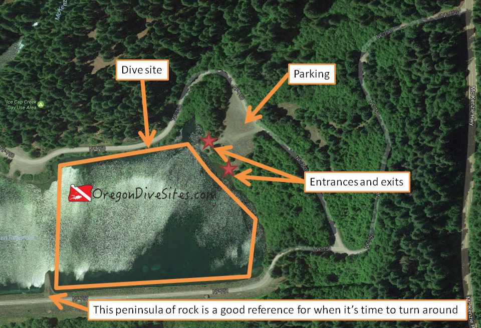
5: Woahink Lake West Boat Ramp

If you were certified in Oregon from any of the shops in the Willamette Valley, there is a good chance that you may have already gone diving at Woahink Lake.  The east boat ramp is a favorite training site.  On the western side of the lake, there is a small boat ramp that is sometimes used to launch boats that don’t need to be towed into and out of the water.  This site is also very special because of the wide range of interesting things that have been left underwater by other divers.

Highlights include a toilet, a yellow submarine, bicycles, and an entire KISS concert.  Yes, that’s right.  There is an entire KISS concert waiting to be discovered underwater at this beginner SCUBA diving site.  Check out our dedicated write-up on the Woahink Lake west boat ramp for a site map and more details.

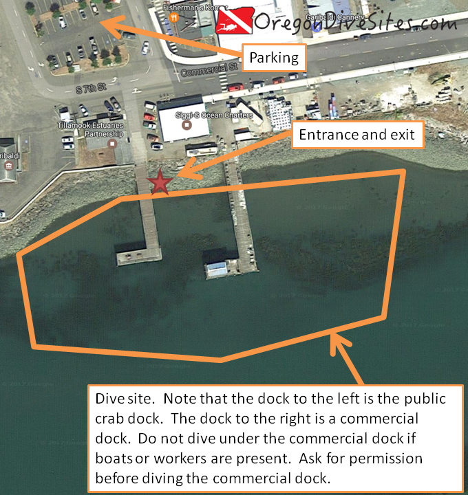
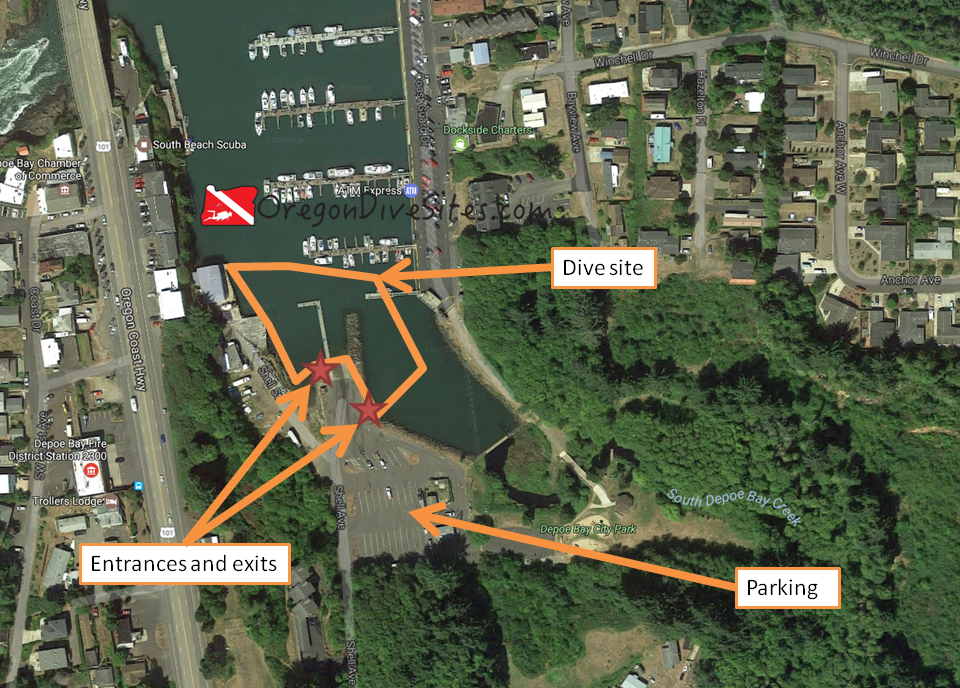
4: Crab Rocks and the Three Graces

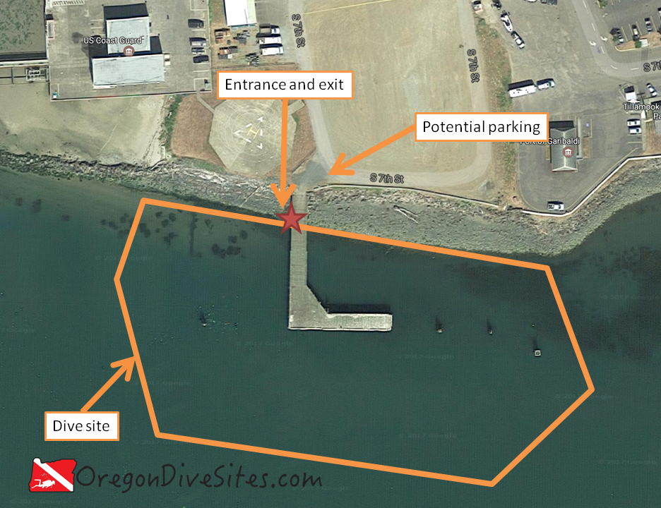
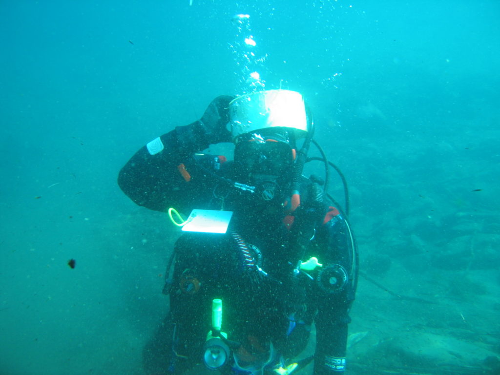
The rock formation along the road and train tracks just south of Garibaldi on the Tillamook Bay is known by several names including Crab Rocks and also the Three Graces.  Whatever you call these rocks, they’re a great dive site for beginner SCUBA divers to hone their navigation skills and buoyancy.  The tidal exchange here creates some interesting currents that can be mildly disorienting which makes for a good environment to hone your compass skills and landmark navigation.

As you become a more skilled SCUBA diver, this site offer up good crabbing opportunities and great spearfishing as well.  If you talk with the folks at the Oregon Coast Scenic Railway very nicely, they might even be talked into dropping you and all of your SCUBA gear off via a steam train!  Check out our write-up on the Crab Rocks / Three Graces dive site for information on max depth, conditions, and more.

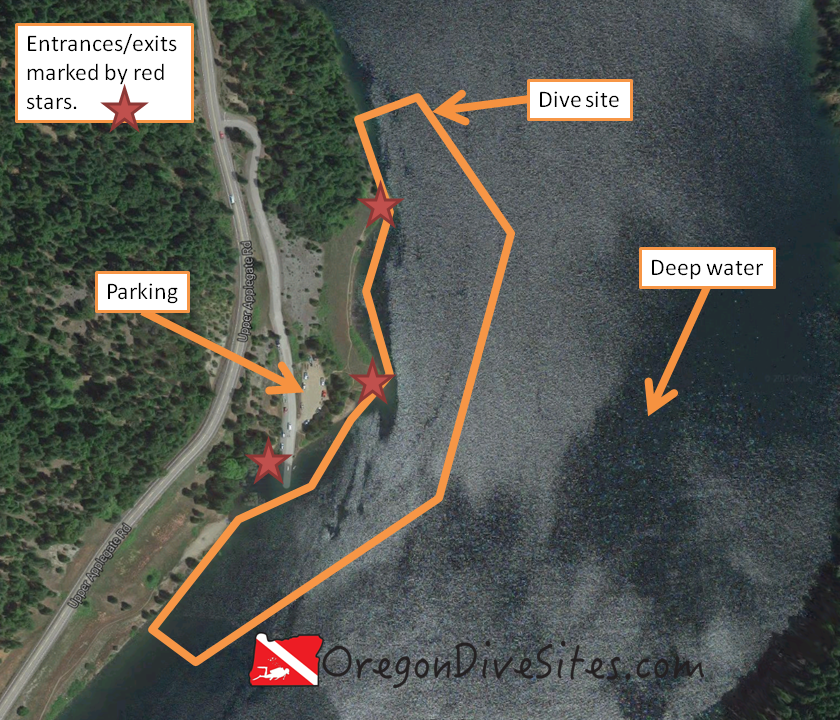
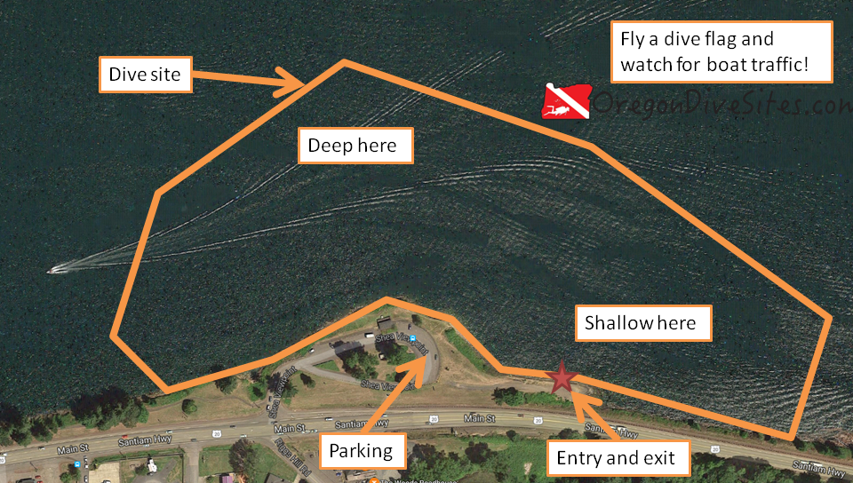
3: Copper Boat Ramp at Applegate Lake

Beginner SCUBA diving sites can be found all over Oregon.  Divers in southern Oregon know the sites around Applegate Lake well but those from the Portland metro area and the Willamette Valley may never have heard of the lake or the Copper Boat Ramp.  Taking a weekend to go down to southern Oregon and dive in Applegate Lake is well worth the drive for beginning divers.

Applegate Reservoir
Applegate Reservoir

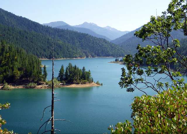
While the lake can be quite deep in spots, the Copper River Boat Ramp is accessible to SCUBA divers who have recently become certified.  The easy entrance and exit along the boat ramp makes this an enjoyable place to dive.  Just make sure to fly a dive flag (we have one we recommend) when diving here.  For detailed information about the Copper River Boat Ramp at Applegate Lake, be sure to check out our write-up on the dive site.

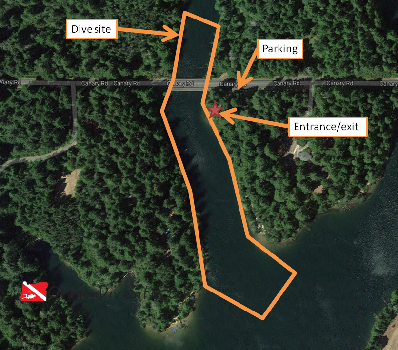
2: Big Pool Swimming Hole on Fall Creek

Beginning SCUBA divers often don’t think about the many rivers in the Oregon Cascades but there are many good dive sites throughout the mountains.  However, many sites in the Cascades count as altitude diving sites that require special altitude diver training.  Based on the PADI standards that we are familiar with, Big Pool Swimming Hole on Fall Creek is just below 1,000 feet and thus counts as a regular dive.  Being just outside of Eugene makes this a good place to do a quick dive after work or to spend a day coming down from Portland or over from Bend to do some diving.

fall creek
Fall Creek from the Unity Covered Bridge a ways below Big Pool Swimming Hole.

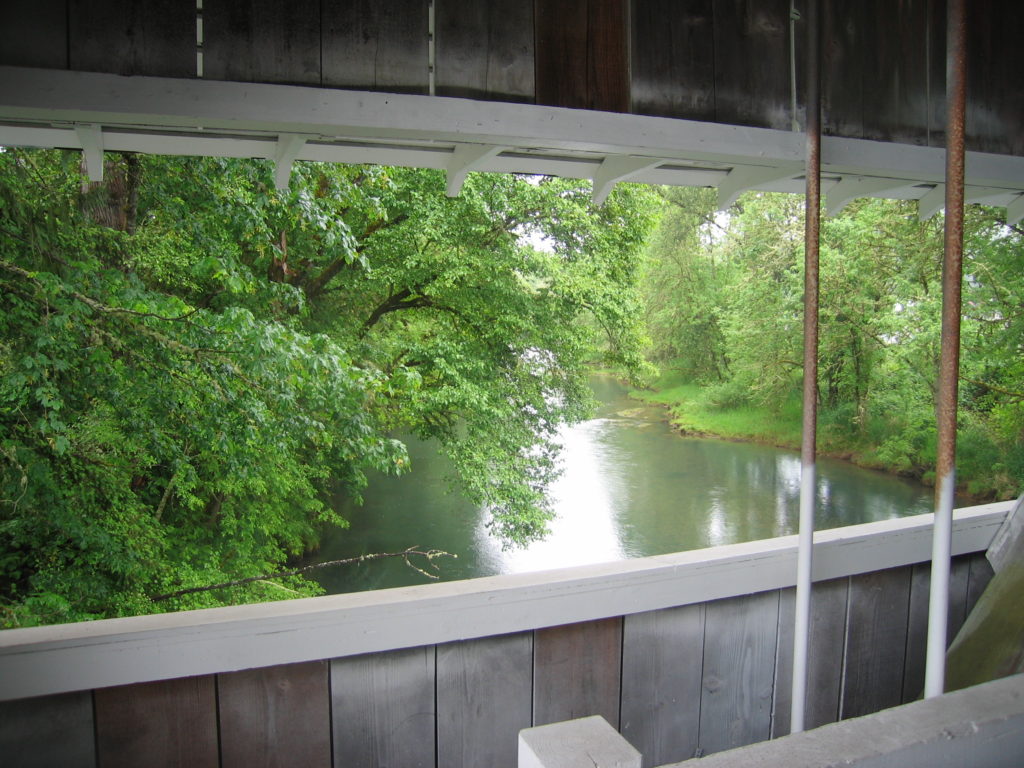
While this site is good in summer and fall, in the winter and spring, water levels can be sufficiently high that the site isn’t very fun to dive.  However, especially on hot days in the summer, it can become very crowded with swimmers which makes it hard to get into the water in full SCUBA gear.  In spite of these issues, this is a great little beginner SCUBA diving site that is well worthwhile to check out as a certified open water diver.  The site is relatively small and quite interesting to go slow while exploring.  Check out our full write-up on the Big Pool Swimming Hole on Fall Creek to get all the details.

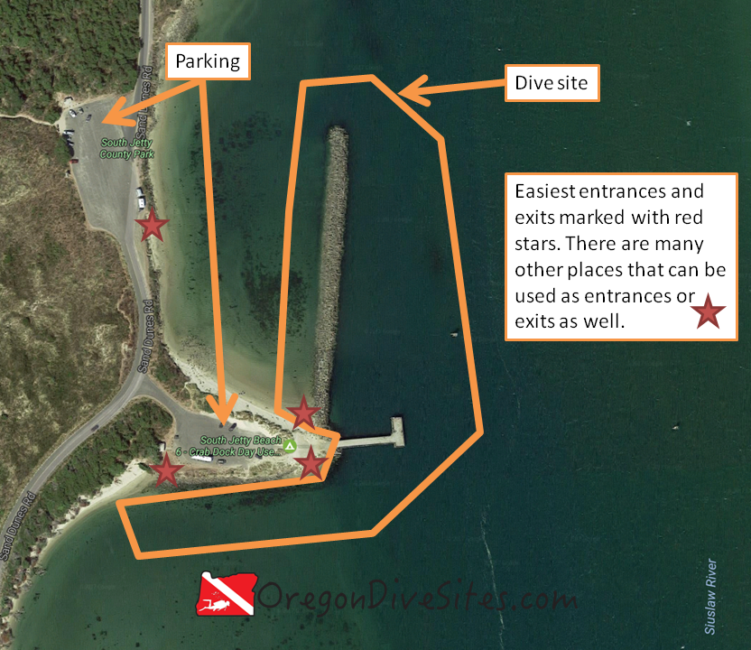
1: Florence North Jetty SCUBA Park

In our opinion, the best beginner SCUBA diving site in Oregon is the SCUBA park on the Florence north jetty.  This dive site is very popular with SCUBA classes and advanced divers alike.  The very easy entrance and exit, which we believe is the easiest on any jetty in Oregon, the good crabbing in Crab Hole, and the fun areas to explore along the base of the jetty keep us coming back to this site again and again.

The Florence north jetty SCUBA Park entrance which we think is the best beginner SCUBA diving site in Oregon.

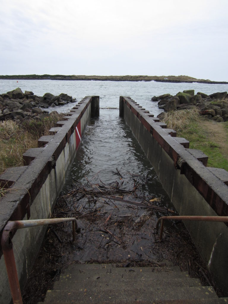
Divers who have just been certified will find this dive site to be a good mix between mild conditions and somewhat challenging tidal currents.  Diving with the tide is necessary for beginner divers.  A little bit of planning will make sure that beginning divers have a great time at the SCUBA park on the north jetty of the Siuslaw River in Florence.  Check out our write-up on the Florence North Jetty SCUBA Park for all fo the details on this great dive site.

The Entire List of Beginner SCUBA Diving Sites in Oregon

If the five best beginner SCUBA diving sites that we reviewed above aren’t enough for you, check out our long list of dive sites in Oregon that are accessible to divers who have just finished their open water SCUBA certification.  If you have any suggestions for other dive sites that are accessible to beginning divers in Oregon, please let us know!

Categories
Southern Cascades, Siskiyous, and Around Klamath Falls

Copper Boat Ramp at Applegate Lake

The Copper Boat Ramp on Applegate Lake is a good place to get wet in the Siskiyou mountains in Southern Oregon. It is one of several boat ramps with good access for SCUBA divers along Applegate Lake.  This being a fresh water reservoir, you will see the standard stuff we expect in Oregon’s man-made lakes such as trout, bass, and other fish; old tree stumps; and the occasional lost fishing rod.  Around the boat ramp you’re more likely to find things dropped by boaters.

Applegate Reservoir
Applegate Lake is an excellent place to do some diving in Southern Oregon.


Nearest Town:

The little town of Ruch is the first place of any size that you will find heading downriver from the lake.  Medford and Grants Pass are just a little further away.

GPS Coordinates:

42.028558, -123.148729

Special Directions to Site:

Once you pass the dam on Upper Applegate Road, keep heading south until you see signs for the Copper Boat Ramp.

Parking:

There is parking near the boat ramp.  Don’t take up spaces for trailers unless you have a trailer.  When we visited last, there was no fee to park but that could change in the future.

applegate lake copper boat ramp
Imagery ©2017 Google, Map data ©2017 Google.
The Copper Boat Ramp on Applegate Lake in the Siskiyous is a good place to get wet in Southern Oregon.

Site Orientation:

The dive site is the flooded canyon of the Applegate River.  The land you want to come back to is to the west.  Deeper water is to the east.  If you start going uphill headed east, you’ve passed the deepest part of the dive site and are heading toward the opposite bank.

Entrances and Exits:

There are a lot of easy entrances/exits here depending on what you want to do.  If you want the easiest entry, just walk on in near the car parking area or over the boat ramp.

Salt/Fresh:

Copper Boat Ramp is a fresh water dive.

Shore/Boat:

This is a shore dive.

Normal Conditions:

In the late summer or early fall the water can get a little stagnant if there hasn’t been rain for a long time and if it was a bad snow year the previous winter.  In the winter, the lake can be drawn very low prepping for spring rains.

Normal Visibility:

Normally you’ll get 10-15 feet of viz here although the bottom can be stirred up so be sure to steer clear of it.

Normal Temperature:

In the early spring when snow melt is pumping into the reservoir, you might find water in the 37F range.  Late in the summer, the Copper Boat Ramp can get a thermocline with temperatures in the upper 60s near the surface and in the low 50s at depth.

Best Time of Year:

This site is good during the summer and sometimes in the fall, depending on lake water levels.

Max Depth:

When the reservoir is full, you can hit around 80-90 feet at this site in the deeper section beyond where we drew the site boundary.

Suggested Special Training:

This is an altitude dive.  You should have altitude diver training to dive this lake.  Open water divers with altitude training can successfully dive this site.

Difficulty of Dive:

We believe this site is suitable for freshly certified open water divers with altitude specialty training.

Distance of Walk to Entrance:

Depending on where you park and lake levels, you might walk 50 feet or 500 feet to your entrance/exit.

Surface Swim Length:

No surface swim is needed.

Special Site Notes:

There is a lot of boat traffic at the Copper Boat Ramp and in Applegate Lake during boating season (summer and fall).  Be sure to fly a dive flag.  We have one we use when we go diving in Oregon.

Closest Local Dive Shops to Get Air Fills and SCUBA Gear:

There are SCUBA shops in Grants Pass and Medford as well as over in Klamath Falls.

Nearby Restaurants We Like:

Jacksonville has some good food.  We haven’t tried any of the closer options so please let us know if you have a favorite place to eat.

Nearby Places to Camp and Diver-Friendly Hotels:

There is a lot of primitive camping and there are a few campgrounds in the area.  We haven’t found a diver-friendly hotel between Ashland and Grants Pass yet.  Please let us know if you know of one that will welcome SCUBA divers and their wet gear.

What Other People Have to Say About This Site:

Please write in the comments below your experiences with this dive site!

Categories
Central Oregon Coast

The South Jetty Crab Dock at Florence

The south jetty crab dock at Florence is a good place to go diving if you’re bored of the north jetty dive sites along the Siuslaw, don’t want to go play in the mud at Woahink Lake, and aren’t feeling like doing the outer parts of the south jetty.  Crabs are usually pretty plentiful here although crabbers and fishermen up on the dock don’t usually enjoy divers underneath them when they’re trying to get some fish or crabs. You can link this dive site up with the other dive sites along the south jetty if you want to do some drift diving and this site is very protected from storms out in the ocean meaning that, as long as you’re okay with bad viz, this site is accessible most of the time.


.


Site Highlights:

This is a great site for SCUBA divers when the conditions are lousy on the north jetty or further out on the south jetty.  Being so far into the Siuslaw Bay, it makes for a well-protected dive site from the worst of the winter storms that often blow out the other dive sites along the Siuslaw.  The south jetty crab dock is also a good place to go crabbing and fishing although you should steer clear of fishermen and crabbers on the surface.  It’s not a bad idea to have a friend stay on the surface to help smooth over any tensions with top-side anglers and crabbers.

Nearest Town:

Florence, Oregon is just over the bridge.

GPS Coordinates:

44.007688, -124.131897

Special Directions to Site:

Heading south from Florence, after you cross the bridge over the Siuslaw River, turn right (west) onto South Jetty Road.  There should be signs for the south jetty county park and day use areas.  Bear to the right onto Sand Dunes Road and follow it until you see signs for the crab dock and south jetty beach 6 day use area.

Parking:

There is some parking right by the dock.  If this is full, just up the road there is a much larger parking area.  There is a day use fee here so be sure to pay it or get the appropriate yearly pass before parking.

Imagery ©2017 Google, Map data ©2017 Google.
The south jetty crab dock along the Siuslaw River is a great site to go dive when conditions are rough further out on the jetty or if you’re looking for a very easy jetty to dive.

Site Orientation:

The jetty runs roughly north-south with a very calm inner bay area to the west of the jetty and a mostly calm southern area south of the jetty.  To the east and north, the jetty is exposed to the Siuslaw River so current becomes much more of a factor.  If you hit this site at the wrong time, you can get sucked out along the jetty or pushed up into the bay.  However, if you’re smart about it, you can turn this into an awesome drift dive.

Be mindful of other users of the site.  Recreational crabbers and anglers can get pretty mad if they think you’re stealing their catch underwater.

Entrances and Exits:

There are a lot of really good entrances and exits at this site.  On the map above, we starred the absolute easiest entrances and exits.  However, you can hop into the water just about anywhere you want.  If you really want a jetty scramble, you can do that.  Otherwise, there are plenty of easy entrances on sandy beaches.  If you enter from the northern parking lot, you’ll be in very shallow water for a while but otherwise all of these entrances and exits are in deeper water.

Salt/Fresh:

This is a salt water dive

Shore/Boat:

This is a shore dive.

Normal Conditions:

Except at high and low tide, the current can really rip along the eastern side of the jetty where the deepest part of the Siuslaw River channel is located.  If you’re doing a drift dive, this is great.  If not, it’s a good idea to stay on the west side of the jetty so you’re not getting pushed around by the water.

There never is much surf or surge here.  We haven’t seen any big waves except when a boat passes by.  In general, this is a pretty benign dive site, and especially when considering that this is on an Oregon coast jetty!

Normal Visibility:

In good conditions at high tide, you can hit 20 feet of viz on the south jetty crab dock.  However, if there is a bunch of silt coming down the Siuslaw River or if there’s a big storm out in the ocean, viz can go down to 5 feet at times.  Usually it’s around 15 feet here.

Normal Temperature:

The south jetty crab dock is impacted by both the water pumping out of the Siuslaw River and by the water out in the Pacific Ocean.  If there is a big spring runoff event with a bunch of snow melt, then you might see 40 degrees.  It can get up to about 60 F on the western little bay area in the summer when the weather is warm and the sun has been out for a few days.  Normally you’ll probably find around 50-55F water temps here.

Best Time of Year:

Any time of year is a good time to check out the south jetty crab dock.

Max Depth:

On the east side of the jetty and near the northern tip of the jetty you’ll sometimes find 25-30 feet of water.  On the west side of the jetty, you’ll be in around 15 feet of water at high tide.

Suggested Special Training:

Recently certified open water divers can successfully dive this site.  If you’re going to do a drift dive, you should have drift diver specialty training.

Difficulty of Dive:

We rate this as an easy dive unless you’re doing drift diving or if you hit the site when the tide is ripping.

Distance of Walk to Entrance:

Depending on where you park and where you enter, you might have between a 5 foot and a 500 foot walk to your entrance.

Surface Swim Length:

If you enter up by the north parking lot, you’ll end up with a 200 foot surface swim to get to deeper water.  Otherwise, the other entrances don’t really need any surface swims to get to the good diving.

Special Site Notes:

Dive this site at high tide for the deepest water you can get at this site.  Especially on the west and south sides, it gets rather shallow.  Be careful of the current in the river channel.  It can go from zero to ripping in just a few seconds.

Be courteous to other users of this site.  There are a lot of people who go crabbing and fishing here.  It’s not a bad idea to have a friend stay on the surface and smooth over any tensions with above-water site users.

It’s a good idea to carry a good dive knife or line cutter.  There can be quite a bit of lost monofilament at this site.  Getting tangled in fishing line sucks but if you have a good knife, you can get yourself free.

Closest Local Dive Shops to Get Air Fills and SCUBA Gear:

You have a long way to go for a dive shop or air fill.  There is a by-appointment-only air fill station up in Depoe Bay and another down in Port Orford.  Otherwise, head over the coast range mountains to Eugene where there’s a full service dive shop.

Nearby Restaurants We Like:

There is a lot of good food in old town Florence along the waterfront.

Nearby Places to Camp and Diver-Friendly Hotels:

There are a lot of county, state, and federal campgrounds in the area that are great for tent camping or for an RV.  We’ve based out of a few of the campgrounds around here to go diving and haven’t been disappointed.

We haven’t tried out any of the hotels in the area so please let us know if there’s a SCUBA diver friendly hotel nearby that you like.

What Other People Have to Say About This Site:

Please write in the comments below your experiences with this dive site!

Categories
Northern Oregon Coast

The Crab Dock at Garibaldi

When the weather is too rough to dive the jetties on the mouth of Tillamook Bay and when there are too many people diving The Three Graces, the crab dock at the Port of Girabaldi is a good backup plan.  The conditions are almost always favorable here and there usually aren’t many other divers at this site.  You do need to plan around the tides though because at low tide, most of this site is a mud flat.

NWP Photo Contest entry, Scenic/Seasonal, Chris Rauch; Engineering and Construction Division
The commercial dock, crab dock, and lumber dock are all along the south riprap at the Port of Girabaldi. There is some confusion in the SCUBA community over which dock is which. We think that the middle dock is the crab dock.


Site Highlights:

This is a good site to go diving if the conditions further toward the mouth of Tillamook Bay are too rough or too crowded.  People come to the crab dock in Garibaldi to work on their diving skills in salt water but in relatively benign conditions.  While there still is a jetty-style entry to contend with, there is almost never surf, surge, or current here.  The nearby lumber dock can sometimes get crowded or have a ship occupying the dock.  In that case, the crab dock is a good place to check out for a dive.

Nearest Town:

This dive site is in the middle of Garibaldi, Oregon.

GPS Coordinates:

45.554202, -123.913896


Special Directions to Site:

In Garibaldi, turn south on 7th street near the lumber mill.  Go all the way to the end of the road.

Parking:

There is ample public parking about a block away from the dive site.  The last time we were here, parking was free but the Port of Garibaldi might start charging for parking so be sure to check signs.

[Aerial View of dive site]

garibaldi crab dock
Imagery ©2017 Google, Map data ©2017 Google.
The Garibaldi crab dock is a good place to dive if conditions are not favorable further out on Tillamook Bay.

Site Orientation:

The public crab dock runs roughly north-south from the riprap wall out into the shipping channel.  The commercial dock just to the east of the public crab dock can be dived at the same time as the public crab dock but you should not dive the commercial dock if a boat is tied up or if there are workers on the dock.  Ask for permission from the charter company at the foot of the commercial dock before diving it.

Entrances and Exits:

The entrance/exit is over the riprap at the base of the crab dock.  The Port of Garibaldi office to the west might let you enter over the riprap near their building but you need to ask permission before you enter over there.

Salt/Fresh:

This is a salt water dive.

Shore/Boat:

This is a shore dive.

Normal Conditions:

At high tide, this site is usually pretty calm and straight forward to dive.  We haven’t seen surf, surge, or much current here.  When the tidal exchange starts, the current can pick up.  Be sure to dive at high tide both so that you aren’t swimming in a mud flat and so that you aren’t getting pushed around by the current.

Normal Visibility:

Unless the bottom is stirred up, you can usually get 10-15 feet of viz here.  Storm conditions can cause more sediment to come down the creeks and rivers in Tillamook Bay and shipping traffic to the Port of Garibaldi can stir things up.  Be sure to stay off the bottom because some of the bottom is mud.  Other parts of the bottom are sand though.

Normal Temperature:

It’s usually 50-55F here although cold water can invade this area from the streams and rivers up-bay.  In the summer it can be warmer on average and in the winter it’s usually a bit colder.

Best Time of Year:

This site can be dived at any time during the year.

Max Depth:

If you bring a shovel and start digging, you might hit 25 feet at high tide.

Suggested Special Training:

This site is accessible to freshly certified open water divers.

Difficulty of Dive:

Aside from climbing over the riprap wall, this is an easy dive.

Distance of Walk to Entrance:

If parking is bad, you may have to walk up to 1000 feet.  Usually though you only need to walk a short city block to get to the water.

Surface Swim Length:

You will want to kick out 50 feet from the riprap so the water is a bit deeper before starting your dive.

Special Site Notes:

This site MUST be dived at high tide.  The whole area turns into a mud flat at low tide which is no fun to dive in.  The Port of Garibaldi is an active port so watch out for boat traffic and fly a dive flag.  You should ask permission before diving the commercial dock to the east of the crab dock.

Closest Local Dive Shops to Get Air Fills and SCUBA Gear:

There used to be an air fill station in Garibaldi on Commercial Street near the cannery but we haven’t been able to confirm if it still exists.  Please let us know if you find it still open!  Otherwise,  your closest air fills are available at the full service SCUBA shop in Astoria or one of the shops in Portland or Salem.  There is also an air fill station at the time of this writing in Depoe Bay that is open by appointment only.

Nearby Restaurants We Like:

There are some good restaurants in Garibaldi and everyone’s favorite cheese factory is just up the road in Tillamook.

Nearby Places to Camp and Diver-Friendly Hotels:

There are plenty of public and private campgrounds and RV parks in the immediate vicinity.  We haven’t stayed in any of the hotels in the area so please let us know if you find one that accepts SCUBA divers.

What Other People Have to Say About This Site:

Please write in the comments below your experiences with this dive site!

Categories
Northern Oregon Coast

The Lumber Dock at Garibaldi

The lumber dock at Garibaldi is a favorite of many Oregon divers.  It is a mellow, easy dive that is almost always a good bet at high tide even if a storm is raging out on the jetty at Barview.  The water is shallow and there isn’t much current here.  The piers have lots of marine life on them to explore.  Sometimes you can find a crab or two that are of legal size and occasionally a perch will swim by that’s worth spearing although hunting isn’t the main reason to come dive this site.

NWP Photo Contest entry, Scenic/Seasonal, Chris Rauch; Engineering and Construction Division
The commercial dock, crab dock, and lumber dock at Garibaldi all in one photo at sunset.


Site Highlights:

A quick note on which dock we’re talking about… There is some confusion online and among our SCUBA friends over exactly which dock at the Port of Girabaldi is the “Lumber Dock” that everyone talks about.  We believe it is the dock farthest to the west along the south riprap wall that is publicly accessible.  Further to the west is the Coast Guard Station and further to the east is what we believe is the “crab dock.”  Even further east is a commercial dock.

The main highlight of this and the other sites at the port is that the conditions here are almost always good.  When the sites further down the bay, such as the Three Graces, or the South Tillamook Bay Jetty, are blown out due to storms, the docks in Garibaldi allow you to still get in the water and have a good dive.  Underwater you’ll find some good marine life on some of the piers and pilings.  There isn’t much else to see at this site so don’t get too excited for great hunting or good marine life viewing.  For what it is though, the lumber dock is a fun little dive.

Nearest Town:

The lumber dock is in the middle of Garibaldi.

GPS Coordinates:

45.554179, -123.915854

Special Directions to Site:

This dive site is at the south end of the Port of Garibaldi.  Head south on 7th Street past the small RV park.  The dive site is just south of the coast guard station helipad.

Parking:

The last time we were here, we could park in the gravel area right in front of the dock.  However, we think that this might be closed off now.  If it is closed off, there is free parking a block north.  Double-check that it’s still free though.  You could try asking at the Port of Garibaldi office just to the east of the dive site about if you can get access to and park right next to the dock with your car.

lumber dock at garibaldi
Imagery ©2017 Google, Map data ©2017 Google.
The lumber dock at Garibaldi is a good place to go if the weather is too rough to dive the jetty.

Site Orientation:

The dock runs south from the riprap wall and then runs east toward several pilings that are used to tie up ships.  We have never seen a ship unloading here but it is possible that one might be on this dock.  If that’s the case, one of the other docks in Garibaldi is a better choice.

Navigating out to the pilings away from the dock is a fun challenge.  If you keep going south, west, or east beyond the pilings, there isn’t much other than a sand and mud bottom.

Entrances and Exits:

You have to climb over the riprap wall at the base of the dock.  It’s a bit scrambly but not as bad as some of the jetty entrances in Oregon.  It’s a good idea to look at what the better side is when you arrive so you know which way you’re going before you gear up.

Salt/Fresh:

This is a salt water dive.

Shore/Boat:

This is a shore dive.

Normal Conditions:

Conditions here are normally pretty good.  It’s rare to have a big wake from a boat in the area.  It’s rarer still to have much wave action.  There can be a little current during the tidal exchange but it’s nothing compared to out on the jetties.  There is boat traffic in the area so it’s a good idea to fly a dive flag.  You also might want to take some dive lights with you to check out the little sea creatures on the pilings.

Normal Visibility:

Depending on what the rivers upstream of Garibaldi are doing, you may have 20+ feet of viz or 5 or less feet of viz.  Usually it seems to be around 10-15 feet.

Normal Temperature:

The water temperature is usually around 50-55F although it can be cooler in the winter with snow melt and cold rain runoff from the Oregon coast range.  In the summer, it can be a bit warmer as well.

Best Time of Year:

You can dive at any time here although you need to dive with the high tide.  At low tide, it’s more of a mud flat than a dive site.

Max Depth:

At a very high tide you might find 25 feet of water at the deepest part of the dive site (south of the dock out in the shipping channel).  You’re more likely to be around 15 feet deep under the dock.

Suggested Special Training:

This is a good site for open water divers to dive right after they’ve been certified.  Aside from the typical Oregon coast jetty scramble, it’s a very easy site to dive.

Difficulty of Dive:

We think this is an easy dive site that anyone can enjoy.  The only real difficulty is getting down to the water.

Distance of Walk to Entrance:

Depending on where you can park, you might have to walk 50 feet or maybe up to 1000 feet.

Surface Swim Length:

It’s a good idea to kick out 50 feet along the lumber dock before going down.  That gets you to some deeper water.

Special Site Notes:

This is an active port area.  It’s a good idea to go talk with the port office before hopping in the water.   If there is a ship tied up at the lumber dock, you shouldn’t dive this dock.

Fly a dive flag and bring a light along so you’re safe while you’re exploring and you can check out all the little life on the piers.

Closest Local Dive Shops to Get Air Fills and SCUBA Gear:

There used to be a place in Garibaldi where you could get an air fill.  We think it closed a few years back.  There also used to be a place in Tillamook but it appears to have closed, too.  The closest reliable sources for air fills and gear servicing are in Astoria and Portland.  It’s a good idea to be self-sufficient in the Tillamook Bay so you aren’t spending hours driving back and forth to Portland.

Nearby Restaurants We Like:

There are plenty of good restaurants all around the bay.

Nearby Places to Camp and Diver-Friendly Hotels:

We haven’t tried any of the hotels in the area but there is plenty of camping (including RV sites right by the dive site!) around the area.  If you go back into the forest in the right places, you can primitive camp, too.

What Other People Have to Say About This Site:

Please write in the comments below your experiences with this dive site!

Categories
Central Cascades

Ice Cap Creek at Carmen Reservoir

The Ice Cap Creek Day Use Area at Carmen Reservoir is a fun place to play around in a submerged creek bed to practice your drift diving skills.  Since this is an altitude dive, it’s a good place to practice using the altitude dive tables.  The water is usually quite cold but not as cold (usually) as Clear Lake can be at the bottom of Clear Lake’s underwater springs.

old metal pot
We found an old metal pot the last time we were at this dive site.


Site Highlights:

There are a couple reasons that SCUBA folks like diving the Ice Cap Creek Day Use Area.  The site has very easy access to get into and out of the water.  You can practice drift diving in the submerged riverbed.  The site is mostly easy to dive making it accessible to even freshly certified open water divers, assuming you have proper altitude diver training.  In short: this is a good site to play around at and practice your skills.  You might also discover some old pots and pans, logging equipment, and other odds and ends tossed into the reservoir.

Nearest Town:

This dive site is pretty remote.  There are very limited services at the resort at Clear Lake.  Otherwise slightly bigger towns within an hour drive are Detroit, Rainbow, and Sisters.  Bigger towns with services are Eugene, Salem, and Bend although they are all more than an hour away.

GPS Coordinates:

44.340039, -122.002339

Special Directions to Site:

The forest road NF-750 gives access to the Ice Cap Creek Day Use Area.  The road is a mile and a half or so south (down river) from the bottom of Clear Lake.  Watch carefully for the signs because it is easy to miss the turn.

Parking:

The last time we were here, there was ample free parking and several locations.  Double check when you arrive to make sure that the parking is still free.  It’s possible the National Forest might turn this into a fee pay site.


carmen reservoir ice cap creek
Imagery ©2017 Google, Map data ©2017 Google.
The Ice Cap Creek Day Use Area at Carmen Reservoir is a good place to do some high altitude diving in Oregon. The river coming into the reservoir can be fun to explore.

Site Orientation:

The site is roughly oriented to the cardinal directions (north-south-east-west).  The Ice Cap Creek Day Use Area is at the north end of the site and with the McKenzie River’s sunken channel coming in at the top end of the dive site.  The river channel runs from the northeast to the southwest where it terminates at the dam’s spillway.  Don’t get too close to the spillway structure!  You don’t want to end up downriver of the dam or getting sucked into the water intake.  You can swim up the river channel under the bridge quite a ways.  This makes for a good spot to practice drift diving.

On the east side of the site, we usually use the finger-like jetty structure on the dam to the south and the parking area to the north as our site boundary.  Further to the east is the other dive site at Carmen Reservoir.

On the northwest side of the dive site, the water gets very shallow.  We don’t think there’s much reason to explore that area.

Entrances and Exits:

The two easiest entrances/exits are at the parking areas.  There is a bit of a scramble step or two to get down to the water but it isn’t too bad.

Salt/Fresh:

This is a fresh water dive.

Shore/Boat:

This is a shore dive.

Normal Conditions:

Normally the water is cold and clear.  There is always a current around the sunken river channel.  Boats can occasionally be in the lake so it’s a good idea to fly a dive flag.  Note that this is an altitude dive.

Normal Visibility:

Usually visibility is quite good since the majority of the water is coming almost directly out of Clear Lake.  Expect 20-40 feet of viz depending on how much surface runoff is coming into the lake.  Close to the Ice Cap Creek Day Use Area you can run into silt on the bottom that can be stirred up but as long as you’re near the sunken river channel, any silt that is stirred up clears quickly.

Normal Temperature:

We’ve seen water temperatures in the river channel as cold as 38F and temps away from the channel near the surface as high as 60F depending on the time of the year.

Best Time of Year:

This site is best in the summer and fall.  Once the snow melts enough for the road to open in the spring, the water is usually very cold.  In the winter, you can’t get to the lake because of the snow.

Max Depth:

We once found 60 feet near the dam in the old river channel but most of the site is more in the 20-40 foot range.

Suggested Special Training:

This is an altitude site where you should have altitude diver training.  Open water divers can successfully dive this site as long as you stay away from the dam intake structure.  This is a great place to practice your dive skills and do training.

Difficulty of Dive:

We think this is a pretty easy dive for the most part so we rate it as a beginner skill level site.

Distance of Walk to Entrance:

Unless there are a lot of people parked at the parking areas, you shouldn’t have to walk more than 50 feet.

Surface Swim Length:

No surface swim is needed.

Special Site Notes:

Because of how cold the water here can be, you should make sure your equipment is rated for cold water.  We have had a regulator free flow up at Clear Lake just up the river.  Be sure to remember your training in case you have that situation happen to you.

The dam intake structure can suck you in, chew you up, kill you very dead, and leave a hefty bill for your next of kin to recover your sliced and diced body.  Steer clear of it!

Closest Local Dive Shops to Get Air Fills and SCUBA Gear:

The closest dive shops are located in Bend, Salem, and Eugene.  Each is quite a ways away (1.5+ hours) so you need to be self-sufficient at the Ice Cap Creek Day Use Area.

Nearby Restaurants We Like:

The closest food is up at Clear Lake’s resort where very limited food service is available.  Otherwise, in Detroit, Camp Sherman, and Rainbow (all towns within an hour of the site) you can find a few restaurants.

Nearby Places to Camp and Diver-Friendly Hotels:

If you want to sleep in a cabin, the resort at Clear Lake does rent cabins to divers.  Be sure to ask when you make your reservation about how you can store your gear.  Otherwise, there are plenty of National Forest campgrounds and lots of primitive camping in the forest.

What Other People Have to Say About This Site:

Please write in the comments below your experiences with this dive site!

Categories
Central Cascades

East Boat Ramp at Carmen Reservoir

The east boat ramp at Carmen Reservoir is a god place to go practice your navigation skills.  Due to the altitude and it being cold fresh water, there isn’t much in the way of life in the lake aside from some algae and a few fish but the wide space by the boat ramp is a good place to hone skills and practice altitude diving.  The scenery is outstanding and well worth the trip on its own.

Panorama of Carmen Reservoir in Oregon 2009
The east boat ramp at Carmen Reservoir is a picturesque lake in the mountains outside of Eugene.


Site Highlights:

We have used this site as a training site to practice navigation skills.  Whether you’re practicing compass headings, kick cycle counts, trench search patterns, or more advanced navigation, this site is a good place to hone your skill set before going somewhere less forgiving.  The dam is a good representation of Oregon coast jetties and can be used for practice entering and exiting over difficult jetty rocks.  Or if you don’t want to work too hard, you can walk right on on the boat ramp and have a wonderful low stress dive.

Nearest Town:

Bend, Eugene, and Salem are all about equally far away.  There are a few small hamlets in between with limited services.

GPS Coordinates:

44.340262, -121.999272

Special Directions to Site:

Look for National Forest Road 750 (to the west) as you’re going along the Mc Kenzie River Highway.  There are signs for the lake, the day use area further to the west, and the boat ramp.

Parking:

The last time we were here, parking was free and plentiful.  As always, verify that the situation hasn’t changed when you go dive the east boat ramp at Carmen Reservoir.


ice cap creek east boat ramp
Imagery ©2017 Google, Map data ©2017 Google.
The Ice Cap Creek east boat ramp is a good place to practice navigation skills.

Site Orientation:

This site is bounded by the dam to the south (it runs east-west), the road and shore to the north, the shore to the east, and a good marker for the western extent of the site is a protrusion of the dam that looks an awful like some of the fingers on the south jetty in Newport.  You don’t want to go further west on the dam past the protrusion of rocks because you will get close to the water exit which is something you don’t want to get sucked into. You would have a very bad day indeed if you went through the business end of the dam.

Entrances and Exits:

The boat ramp itself makes for a very easy entrance.  There is another easy entrance a little to the east and south along the shore that is a simple step down into the water.  Along the road on the north end of the site, you can scramble in/out on the bank if you really have to but there isn’t much reason to do that as long as your navigation skills are up to snuff.  At the far northwestern corner of the site, you can climb out into a parking area that is part of the Ice Cap Creek Day Use Area although you will have a bit of a walk back to your car.  If you want to practice entering and exiting over a jetty structure, the dam on the south side of the dive site gives you that practice.

Salt/Fresh:

This is a fresh water dive.

Shore/Boat:

This is a shore dive.

Normal Conditions:

Conditions during the summer and fall are usually pretty good here.  The constant feed of cold fresh water keeps visibility fairly decent.  Water levels can change rapidly depending on what the dam operator is doing.  There can be boats in this area so it’s a good idea to fly a dive flag.

Normal Visibility:

We usually have between 15 and 30 feet of viz depending on the time of year and how much surface water runoff there is coming into the lake.  The bottom can be stirred up so it’s a good idea to maintain neutral buoyancy.

Normal Temperature:

The water coming in from Ice Cap Spring is very cold.  Near the creek, it can easily be 37F.  In the summers, there can be a thermocline at the surface with a warm layer of water followed by very cold water at depth.

Best Time of Year:

This site is best done in the summer and fall.  In the winter and spring, there is usually too much snow on the ground to access the lake.

Max Depth:

We found 55 feet here once without trying too hard.  We suspect you can hit around 70 feet out in the middle.

Suggested Special Training:

This is an altitude dive.  An open water diver with altitude diver training can dive this site without a problem.

Difficulty of Dive:

Aside from the altitude dive aspect of this site, the east boat ramp at Carmen Reservoir is an easy place to dive.  We have assisted with several training dives here in the past and enjoy this site for its easy access, its relatively benign conditions, and the chance to practice navigation.

Distance of Walk to Entrance:

Depending on how close you can park, you might only need to walk 20 feet to be in the water.

Surface Swim Length:

No surface swim is needed at the east boat ramp at Carmen Reservoir unless you’re bad at navigation and don’t monitor your air supply.

Special Site Notes:

Remember that this is an altitude dive.  Boats can be at this site so it’s a good idea to fly a dive flag.  We usually bring a SCUBA light with us when we dive the east boat ramp at Carmen Reservoir so we can look in all of the little crannies and crevices underwater to search for crayfish and trout.

Closest Local Dive Shops to Get Air Fills and SCUBA Gear:

There aren’t any shops nearby.  You’ll have to go to Eugene, Salem, or Bend to find a dive shop.  You need to be self-sufficient diving this site.

Nearby Restaurants We Like:

There is limited food service at Clear Lake but otherwise there aren’t any restaurants up here.

Nearby Places to Camp and Diver-Friendly Hotels:

The resort at Clear Lake has some cabins for rent that some of our SCUBA buddies have stayed at before.  Otherwise there is plentiful camping in the national forest both in campgrounds and at primitive sites.

What Other People Have to Say About This Site:

Please write in the comments below your experiences with this dive site!

Categories
Central Cascades

Shea Viewpoint at Foster Reservoir

If you’re looking for an easily accessible dive site at Foster Reservoir where you can go deep or stay shallow and have a good time, check out Shea Viewpoint.  The topography at this site starts shallow on the right but gets really deep on the left.  This is a good place to do training dives as well.


Site Highlights:

This site has a variety of terrain that keeps it interesting for a fresh water reservoir in the Cascades.  We have spent a few afternoons doing training dives here.  One summer the water was so warm in the shallows while we were running a knot skills station, we had to ditch our thermal undergarments, hoods, and gloves, and we were STILL sweating in our suits just sitting on the bottom.  Going deeper, we found chilly 45 degree water.  The thermoclines are real at this site.

Nearest Town:

Sweethome, Oregon is just below the dam.

GPS Coordinates:

44.410477, -122.653649


Special Directions to Site:

Just head east on the Santiam Highway out of Sweethome toward Bend.  You’ll find the Shea Viewpoint along the reservoir.

Parking:

Usually there is plenty of parking at Shea Viewpoint.  The last time we went diving here, the parking was free.  Double-check when you arrive that it still is though.

shea viewpoint
Imagery ©2017 Google, Map data ©2017 Google.
Shea Viewpoint is a pretty good dive site on Foster Reservoir. We like this site for its varied underwater terrain and easy entry and exit.

Site Orientation:

This site is pretty easy to navigate.  Shore is to the south.  Shallow water is to the east.  Deep water is to the west and north.  Off the north and west sides of Shaw Viewpoint there is a large underwater sloped boulder field that is fun to explore.  The boulder field keeps going down, down, down.  We never found the bottom because it got too deep for our dive plans.

Entrances and Exits:

There is an easy entrance/exit where we think there used to be a boat ramp at the east side of Shaw Viewpoint.  You can walk right down into the water.

Salt/Fresh:

This is a fresh water dive.

Shore/Boat:

This is a shore dive although you could do a boat dive here, too, if you wanted.

Normal Conditions:

Unless a storm comes up over the lake, the only real issues at this site are boats going by and making wakes.  There can be some pretty big thermoclines here, too.

Normal Visibility:

We’ve had as little as 5 feet of visibility and as much as 40 feet of viz here.  The bottom can be stirred up pretty easily and spring snowmelt can decrease viz.  We’ve found better visibility the deeper we go at this site.

Normal Temperature:

At depth, the temperature is usually around 45F.  At the surface in late summer, it can be in the high 70s or even low 80s near the surface in the shallows.  Early in the spring during peak snowmelt, there can be a layer of 37F water here.

Best Time of Year:

We like diving this site in the late summer to enjoy that warm surface layer of water before going deep into the dark and cold.  Depending on when you dive this site, the water level in Foster Reservoir can be very low which makes for a longer walk to get to the water.

Max Depth:

We’ve been down as far as 95 feet deep here but the bottom keeps going down.  We suspect that you can easily hit 130 feet if you keep heading north and west.

Suggested Special Training:

Open water divers can easily dive the shallower parts of this site.  The deeper parts warrant having advanced open water training and deep diver specialty training.

Difficulty of Dive:

The shallower parts of this site are easy to dive.  The deeper parts of the site become progressively more challenging.

Distance of Walk to Entrance:

Depending on the water level in the reservoir, you might have to walk 100 feet or 500 feet to get to the water’s edge.

Surface Swim Length:

No surface swim is necessary here normally.

Special Site Notes:

We suggest flying a dive flag here because of boat traffic.  We have our favorite dive flag that we use when we go SCUBA diving in Oregon over on our Gear We Use page.

Closest Local Dive Shops to Get Air Fills and SCUBA Gear:

There are dive shops in Eugene and Salem with

Nearby Restaurants We Like:

There are some decent places to eat in Sweethome.  We usually eat at the A&W Drive-In for the nostalgia vibe.

Nearby Places to Camp and Diver-Friendly Hotels:

There are a few campgrounds nearby and there is primitive camping in the national forest.  We haven’t tried any of the hotels in the area so please let us know if you have a good recommendations.

What Other People Have to Say About This Site:

Please write in the comments below your experiences with this dive site!

Categories
Central Oregon Coast

Woahink Lake West Boat Ramp and Bridge

The west boat ramp by the bridge on Woahink Lake is a dive that just about every one of our SCUBA friends in Oregon has done at least once.  It is a popular place for training dives and a fun place to rinse gear in fresh water after diving at the SCUBA park on the Florence jetty.  While the site is relatively small and visibility can be poor, people keep coming back here because of the quirky things left underwater by other divers.  Everyone always seems to mention the KISS concert whenever they talk about this site.

Site Highlights:

The reason that we come to this site is to see what new things have been added to the treasure trove of random stuff that divers have left underwater.  Someone posed figurines of the band KISS into a mini concert on the north side of the dive site.  There’s a toilet or two with funny things in the bowls.  On the south end, we heard there might be a sunken model submarine.

Nearest Town:

Florence, Oregon is just up the road from the dive site.

GPS Coordinates:

43.929335, -124.102980

Special Directions to Site:

Look for the signs for Jessie M. Honeyman State Park.  Turn east onto Canary Road.  Immediately after the first small bridge, park on the right.

Parking:

There is minimal parking at this site.  One big dive group will take up all the space.  The site is often popular with SCUBA classes for Open Water courses so it’s a good idea to have some backup sites in mind like the East Boat Ramp at Woahink or the SCUBA Park on the North Jetty.

Imagery ©2017 Google, Map data ©2017 Google.
The little SCUBA park that has been made at the old west boat ramp at Woahink Lake is a fun spot to spend a dive or two looking at all of the odd things people have left underwater.

Site Orientation:

The site runs more or less north-south.  There are a few things just north of the bridge but heading further up this finger of Woahink Lake won’t lead to anything interesting other than a few fallen trees.  To the south past the submarine, you will find deeper water but not much else.

Entrances and Exits:

The old boat ramp at the southeast corner of the bridge is an easy entrance.  The last time we were here, there was a bit of a step down from the asphalt to the water but it wasn’t too bad.

Salt/Fresh:

This is a fresh water dive.

Shore/Boat:

This is a shore dive.

Normal Conditions:

Conditions here are usually very benign.  If an open water SCUBA class just got out of the water, visibility will be lousy though.

Normal Visibility:

If no one has gone diving at the site in the last day, we usually get 10-15 feet of viz at the west boat ramp in Woahink Lake.  However, the bottom stirs up very easily and can reduce visibility to less than 5 feet.  This is a good place to practice neutral buoyancy.

Normal Temperature:

Usually it’s between 48 and 56F here although we have seen it a little colder and a little warmer depending on the time of year.

Best Time of Year:

Any time of the year is a good time to go diving at Woahink Lake.

Max Depth:

We’ve hit 30 feet on the south side of this dive site but most of the site is a bit shallower.

Suggested Special Training:

You can dive this site as soon as you have your open water diving certification.

Difficulty of Dive:

This is a pretty easy dive.  There are a few submerged trees that you could get tangled in at the edges of the dive site but otherwise there aren’t any significant hazards that we’re aware of.

Distance of Walk to Entrance:

If you have to park at the farthest parking spot, you might have to walk 200 feet.  At the closest spot, you’ll need to walk about 50 feet.

Surface Swim Length:

No surface swim is needed at this Woahink Lake dive site.

Special Site Notes:

This site gets a LOT of use from regional SCUBA shops.  If a class is using the west boat ramp on Woahink Lake, go try the east boat ramp or the SCUBA park on the north jetty.

[Underwater Map of Dive Site Coming Soon!]

Closest Local Dive Shops to Get Air Fills and SCUBA Gear:

There used to be a fill station in Florence but we recently heard (February 2017) that it is no longer operating.  The closest place to get an air fill or gear service is in Eugene.  Port Orford to the south or Depoe Bay to the north also may still have air fill stations.

Nearby Restaurants We Like:

There are a lot of good places to eat along the old waterfront in Florence.  We usually see river otters playing on the riverbank there, too!

Nearby Places to Camp and Diver-Friendly Hotels:

There are several state campgrounds in the area that are a good place to base yourself for a few days of diving in Florence.  We haven’t tried any of the hotels so please let us know if you have a favorite that is good for divers.

What Other People Have to Say About This Site:

Please write in the comments below your experiences with this dive site!

Categories
Central Oregon Coast

Depoe Bay Boat Ramp

The boat ramp at Depoe Bay is a good place to check gear out before diving offshore.  If conditions are lousy, you can spend an enjoyable hour searching around underwater for cast off junk from the industries that have occupied the world’s smallest harbor.

depoe bay
The boat ramp in Depoe Bay is a good place to check your gear out before going for a dive offshore.

Site Highlights:

Even though the site is shallow, you can enjoy some time underwater here testing out gear.  There is a fair amount of junk underwater left from the old businesses that used to be around the harbor.

Nearest Town:

The boat ramp is right in the middle of Depoe Bay.

GPS Coordinates:

44.808141, -124.060102

Special Directions to Site:

From US101, take  Schoolhouse Street east and then then turn left onto Shell Avenue.  The boat ramp and parking are right at the end of the road.

Parking:

There usually is plenty of parking here.  Just make sure not to occupy boat trailer parking.  We haven’t had to pay here before but double check the signs to make sure something hasn’t changed.

depoe bay boat ramp
Imagery ©2017 Google, Map data ©2017 Google.
The boat ramp is a bit cramped and shallow. You could explore more to the north although there is a lot of junk underwater and some old line.

Site Orientation:

Head south to get out of the water.  Head north in search of deeper water.  We suggest you stay out from underneath the boats.  Along the western edge of the harbor there is a lot of junk underwater.  Don’t get entangled in anything!

Entrances and Exits:

You can get in right at the boat ramp or over the little jetty to the right of the boat ramp.  It’s an easy entrance/exit.

Salt/Fresh:

This is a salt water dive.

Shore/Boat:

This is a shore dive.

Normal Conditions:

Depoe Bay is very protected once you’re inside the channel.  Watch out for boat traffic.  It isn’t a bad idea to have someone on the shore to let boaters know you’re underwater.  This harbor is pretty tight to fly a dive flag but it isn’t a bad idea.  We have a favorite flag we use all over Oregon on our Gear We Use page.

Normal Visibility:

Usually you’ll get 5-10 feet of viz here.  The bottom can get stirred up especially on the right side of the dive site where the little creek comes into the harbor.

Normal Temperature:

It can be between 45 and 65F depending on the time of year and how shallow you go.

Best Time of Year:

Water conditions are usually better in the winter than summer but you can dive this site at any time of year.

Max Depth:

If you go north far enough, you might find 20 feet of water but usually you’re going to be in about 10 feet of water.  Buoyancy control is critical here.

Suggested Special Training:

Open water divers can dive here but be careful with underwater entanglement hazards and sunken machinery.  It’s a good idea to carry a good dive knife and line cutter.

Difficulty of Dive:

This is a pretty easy dive but be careful of entanglement hazards.  Boat traffic can also be an issue.

Distance of Walk to Entrance:

50 feet is usual but 150 feet could happen if you have to park a ways away.

Surface Swim Length:

No real surface swim is necessary here.

Special Site Notes:

Be careful of underwater entanglement hazards.  Also watch for boat traffic.

Closest Local Dive Shops to Get Air Fills and SCUBA Gear:

There used to be a dive shop in Depoe Bay but it was in the process of closing when we were last at this site (February 2017).  However, they may still be giving air fills.

Otherwise, you need to head up to Astoria, down to Port Orford, or inland to Portland, Salem, or Eugene to get an air fill and have gear serviced.

Nearby Restaurants We Like:

Tidal Raves has absolutely outstanding food and a great ocean view. Gracie’s Sea Hag has the best clam chowder on the entire Oregon coast.

Nearby Places to Camp and Diver-Friendly Hotels:

South of Depoe Bay is Beverly Beach State Park where there is good camping.  We haven’t tried any of the hotels in the area so please let us know if you have stayed at one that is SCUBA friendly!

What Other People Have to Say About This Site:

Please write in the comments below your experiences with this dive site!