Categories
Central Oregon

Lower Deschutes Boat Ramp at Lake Billy Chinook

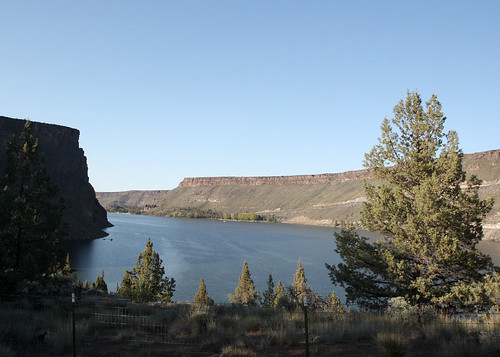
The lower Deschutes boat ramp on Lake Billy Chinook is a good place to go diving in Central Oregon.  You can go very deep here if you want or you can stay more shallow to check out the underwater cliff faces, the underwater rock formations, and search for things lost by boaters.

Cove Palisades SP Oregon 2002.03.31
The lower Deschutes boat ramp at Cove Palisades State Park is on the west side of the “Island” in the middle of this picture. Ipoellet at the English language Wikipedia [GFDL or CC-BY-SA-3.0], via Wikimedia Commons

Site Highlights:

The lower Deschutes boat ramp is an exciting place to dive because of the underwater cliffs and rock formations.  Much like some of the other sites on Lake Billy Chinook, this site has a variety of terrain from relatively shallow sandy areas near the roped-off swimming spots to sheer vertical underwater cliffs.  You can often find things that fell off boats around the boat ramp and other random odds and ends that went overboard in the general dive site area.

Nearest Town:

There are a few small towns nearby including Culver, Metolius, and Madras.  To the south, Bend and Redmond have some dive shops.

GPS Coordinates:

44.547443, -121.279279

Special Directions to Site:

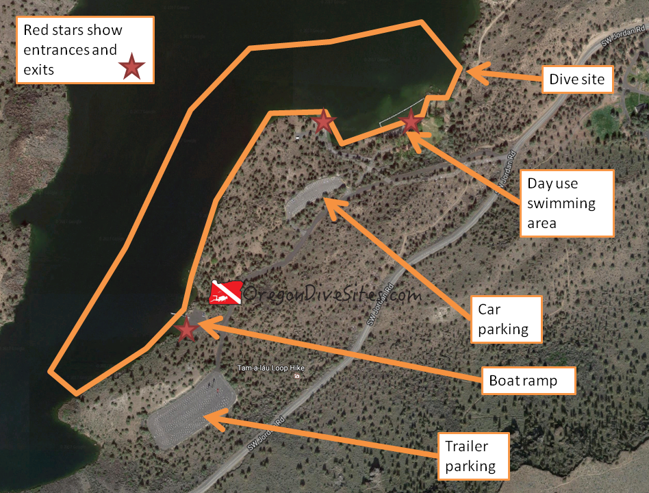
There are signs on US 97 for Cove Palisades State Park.  Follow them through a series of roads until you descend down into the canyon.  Look for signs for the lower Deschutes boat ramp once you’ve crossed the bridge over the Crooked River finger of the lake.
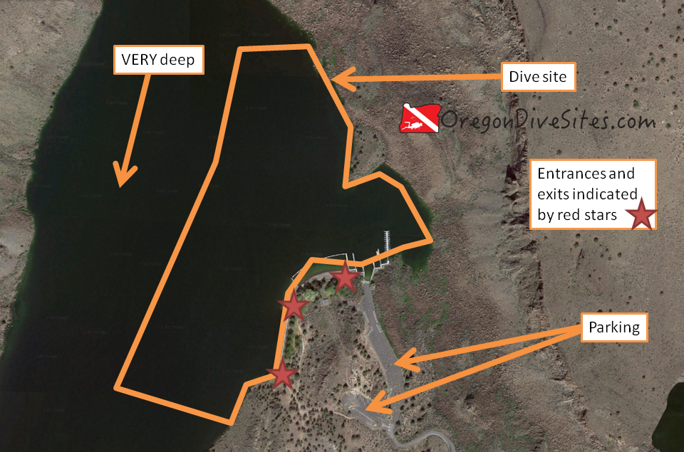
Parking:

There is usually ample parking although on busy summer weekends, it can be completely full.  The last time we were here, we had to pay a day use fee to park.  Your Oregon State Parks Pass might work here but double-check when you go to park to see what you need to do.  You can drop your gear off down by the boat ramp after you have your equipment setup and then go park in the car parking area.  If it’s a quiet day with not many boat trailers, you can usually get away with leaving your car in the boat trailer parking.


Imagery ©2017 Google, Map data ©2017 Google.
The lower Deschutes boat ramp is a good place to dive in Lake Billy Chinook. The underwater terrain is varied and you can go very deep if you want or you can stay shallower in a few areas.

Site Orientation:

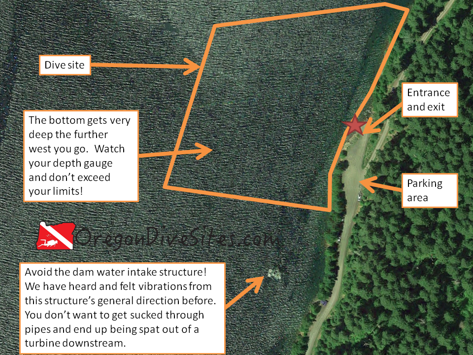
This site runs more or less north-south.  There is a little bay in the middle of the site that heads east and is where the boat ramp is located.  The little bay and the area around the roped off swimming spot are the shallowest and gentlest places to dive.  If you go further west, north, or south, things get deep very quickly and also very steep.  There are some vertical underwater cliffs as well.  If you head west and don’t watch your gauges, you can go beyond recreational scuba depth limits so pay attention!

Entrances and Exits:

If there isn’t much boat traffic, you can hop in at the boat ramp.  Otherwise, the swimming beach is an easy entrance with a nice and sandy spot to walk in.  To the west and south, there are a couple swim ladders you can climb in on from the wall where boats sometimes tie up.

Salt/Fresh:

This is a fresh water dive.

Shore/Boat:

We have done this as a shore dive but you can also do boat diving here.  If you’re spending a long weekend on Lake Billy Chinook with your pontoon boat, this is a good dive site to check out your gear and practice your boat entrances and exits before motoring out into other parts of the lake.

Normal Conditions:

Usually there isn’t much current unless you get deep enough and usually there aren’t many naturally occurring waves.  There can be waves and wake from boats passing by though.  This lake is very popular with many different types of boaters so it’s important to fly a dive flag, even if you’re diving from a boat.

Normal Visibility:

Except in the swimming area and right around the boat ramp, visibility is usually pretty good with viz often being 40-60 feet or better.  Where the water gets stirred up, it can be quite a bit lower.  The bottom doesn’t have much to stir up.

Normal Temperature:

The deeper you go, the colder it usually gets at the lower Deschutes boat ramp.  On the surface in late summer, we’ve seen in the 70s at this SCUBA site while at depth it can still be in the low 40s.

Best Time of Year:

This site is diveable any time of the year although we prefer summer and fall.

Max Depth:

We’ve gone down as far as 80 feet here but you can exceed the maximum recreational SCUBA depth limits if you aren’t careful.

Suggested Special Training:

This is an altitude diving site.  We suggest having at least advanced open water training because of the potential to go very deep very quickly.

Difficulty of Dive:

We rate this as an intermediate dive because of the depth.

Distance of Walk to Entrance:

Depending on how close you can get your car, you may have to walk only a few feet or a couple thousand feet.

Surface Swim Length:

No surface swim is necessary at the lower Deschutes boat ramp.

Special Site Notes:

This site has a lot of boat traffic during high season (summer and fall).  Fly a dive flag!

Closest Local Dive Shops to Get Air Fills and SCUBA Gear:

There are a few SCUBA shops in Bend that offer full service.

Nearby Restaurants We Like:

We haven’t tried any of the restaurants right by the lake so please let us know if you have a favorite.

Nearby Places to Camp and Diver-Friendly Hotels:

There are several state and federal-run campsites in the area as well as a private resort with cabins for rent.

What Other People Have to Say About This Site:

Please write in the comments below your experiences with this dive site!

Categories
Central Oregon Coast

Florence – North Jetty End of the Road Parking Lot

The north jetty on the Siuslaw River at Florence is a great place to do some diving on the Oregon Coast.  At the west parking lot near the observation tower, a short jetty scramble leads to good spearfishing and crabbing.  If you plan your dive with the tide, you can drift dive this site riding the tide out from the SCUBA Park to the east or head that direction if you ride the tide in.

North Jetty in Florence, Oregon
The western parking lot along the north jetty at Florence is a more difficult entrance and exit than the SCUBA park to the east but is a quieter dive site and often has good spearfishing. “North Jetty in Florence, Oregon” by Rick Obst is licensed under CC BY 2.0


Site Highlights:

The main reason we dive this site is to go spearfishing and crabbing.  While Crab Hole further east on the north jetty gets fished all the time, the further west part of the north jetty gets less hunting.  We have done some drift dives here as well where we follow the tide back toward Florence.

Nearest Town:

Florence, Oregon is just up the north jetty.

GPS Coordinates:

44.018318, -124.137102

Special Directions to Site:

From US101, head west on 35th Street.  Take a right on Rhododendron Drive then take a left on North Jetty Drive.  Follow North Jetty Drive all the way to the end.

Parking:

There is usually plenty of free parking right by the jetty.  Check the signs to make sure the situation hasn’t changed, but we’ve never paid for parking here.

Imagery ©2017 Google, Map data ©2017 Google.
There are a lot of options to dive this site. You can hop in at the SCUBA Park entrance and ride the tide as a drift dive to an exit at the west parking lot on the Florence north jetty. Or you can stick close to the west parking lot. Or you can head for the ocean and hop out along the jetty and walk back across the sand.

Site Orientation:

The site runs east-west.  Stick close to the jetty rocks.  We haven’t found much of interest out in the channel other than a bunch of sand.

As you get further west, conditions deteriorate.  The dive becomes more advanced the closer to the tip of the jetty you get.

If you run this as a drift dive, you can drift all the way back to Crab Hole.  Watch for the big underwater pipe that marks the exit through the fish ladder.

Entrances and Exits:

The main entrance/exit here is over the jetty at the parking lot.  If you end up out toward the end of the jetty, you can hop out and walk back on the beach.  If you head in toward Crab Hole, you can get out at the fish ladder.  Just watch for the pipe underwater that leads to the exit.

Salt/Fresh:

This is a salt water dive.

Shore/Boat:

This is a shore dive.

Normal Conditions:

The further to the west you go, the rougher the conditions will get.  At the entrance, you’ll probably find surf and some surge.  Further to the west, you’ll run into much rougher conditions unless the sea is calm.  Breakers routinely crash over the north jetty at the Y-shaped tip.

The current can really rip going into or out of the Siuslaw River.  If you plan your dive right, you can do a great drift dive from the parking lot in toward Crab Hole and then back out again to the parking lot.  If you’re diving around low tide, you could head out on the last ebb of the low tide and then get pushed back into the river by the inrushing tide.  However, this is a more advanced dive.

Normal Visibility:

We usually get 15-20 feet of visibility here.  The bottom is heavy sand and doesn’t easily get stirred up.

Normal Temperature:

We’ve seen anywhere between 45F and 55F depending on the time of year.

Best Time of Year:

The water is usually calmer in the summer and fall here but the site is diveable any time of the year assuming that water conditions aren’t too rough.  If they are too rough, try Crab Hole, or the Woahink west or east boat ramps.

Max Depth:

It’s usually around 35 feet deep at the bottom of the jetty although depending on what the Army Corps of Engineers is doing with dredging the center channel, the depth can vary.

Suggested Special Training:

It would be a good idea to have advanced open water training for this site.  The eastern part of the site is diveable by less experienced divers but the western part of the site requires a lot of experience diving on Oregon jetties.

Difficulty of Dive:

We consider this an intermediate dive as long as you stay far enough inside the jetty.  If you head west toward the tip, this becomes a very advanced and difficult dive.

Distance of Walk to Entrance:

You can usually find parking right next to the jetty but sometimes you might have to walk 200 feet.

Surface Swim Length:

No surface swim is needed here.

Special Site Notes:

Conditions can deteriorate rapidly at this dive site.  The further west you go, the worse it can get.  Be sure you know what you’re doing here.  Don’t get sucked out to sea or pushed way up in the bay.

We suggest flying a dive flag while you’re diving case anyone with a small boat ventures over toward the jetty to check out your bubbles.  We have a dive flag we love and use all the time around Oregon over on our Gear We Use page.

[Underwater Map of Dive Site Coming Soon!]

Closest Local Dive Shops to Get Air Fills and SCUBA Gear:

There used to be an air fill station in Florence but we heard that it is now closed.  The closest place to get a full service on SCUBA gear and air fills is now Eugene.

Nearby Restaurants We Like:

Florence’s old town on the waterfront has a lot of great restaurants.  River otters along the Siuslaw River provide some great entertainment, too.

Nearby Places to Camp and Diver-Friendly Hotels:

There are several state campgrounds in the area that we have stayed at.  We haven’t tried any of the local hotels so please let us know if you know of a good place for divers to stay the night.

What Other People Have to Say About This Site:

Please write in the comments below your experiences with this dive site!

Categories
Central Cascades

Jawbone Flats – Opal Pool

Diving the Opal Pool at Jawbone Flats is a unique experience for Oregon SCUBA divers.  Opal Creek, a tributary of the Little North Fork of the Santiam River, is a gorgeous cascade of water and sparkling lush forest.   The azure waters in the Opal Pool below Opal Pool Falls are inviting in the late summer or early fall.  We have seen many people enjoying a swim here although the water can be chilly.

opal pool
The Opal Pool is a short walk up from Jawbone Flats where you can rent cabins.

Site Highlights:

The main thing we like about this SCUBA dive site is the unique experience of going diving in a gorgeous pool tucked back into the forest far away from the nearest road.  It is a unique and peaceful place to put on dive gear and take a dip.

Underwater the basalt river rocks are mostly smooth and round.  The walls of the pool are all basalt cliffs that add to the drama and beauty of this site.  Someone with a very good camera and some time could make some awesome photos here combining the underwater and the above water beauty of the opal pool at Jawbone Flats.

Nearest Town:

The nearest big city is Salem, Oregon.  The tiny hamlet of Elkhorn is the first thing you will encounter driving down from the Opal Creek Trailhead.  The bigger towns of Mehama and Lyons are a ways further down the road.

GPS Coordinates:

44.844199, -122.206503

Special Directions to Site:

It takes some time to get to Jawbone Flats and the Opal Pool.  First you need to drive to the Opal Creek Trailhead at the end of forest road NF-2209 out of Elkhorn, Oregon.  Then you need to hike up to Jawbone Flats where the Opal Creek Ancient Forest Center is located.  Then you take the trail toward Cedar Flats.   Opal pool is below the bridge not far out of Jawbone Flats.

The whole hike round trip is about seven miles.  Carrying 100lbs of SCUBA gear on your back that distance is infeasible.  There are a couple options though.  You can try talking with the center at Jawbone Flats about having them use their shuttle to bring your gear up to the center and then walk the gear from there.  You can convince a bunch of friends to help you carry in and out your SCUBA gear.  You can also try using a wheeled cart although we aren’t sure if forest regulations allow that.  We personally think staying at Jawbone Flats at the Opal Creek Ancient Forest Center overnight and coordinating with the center to bring your gear in and back out is the best option.

Parking:

You pay to park at the Opal Creek Trailhead.  On popular weekends, the trailhead can be completely full of cars so plan ahead.

opal creek overview
Imagery ©2017 Google, Map data ©2017 Google.
The round trip hike to Opal Pool is a little over seven miles but we think the trip is well worth it for the unique diving experience.
opal creek close up
Imagery ©2017 Google, Map data ©2017 Google.
Once you have hiked up to Jawbone Flats and the Opal Creek Ancient Forest Center, take the trail toward Cedar Flats. Opal Pool isn’t too far away.

Site Orientation:

Opal Pool is down in the creek bed.  The site is so small and the water is so clear that you can’t really get lost here.  Be mindful of other users of the pool.

Entrances and Exits:

It’s a bit of a scramble down to the dive site from the trail but it is manageable.  The rocks can be a bit slippery depending on conditions so watch your footing.

Salt/Fresh:

This is a fresh water dive.

Shore/Boat:

This is a shore dive.

Normal Conditions:

During the summer and fall, the water is usually fairly calm although we have seen quite a few people swimming here on hot weekends.  In the spring during the snow melt, this creek can turn into a raging torrent.  During flood conditions, you will see why it is a bad idea to try diving the site!

Normal Visibility:

Visibility at Opal Pool is usually around 20-30 feet.  You can see the bottom of the deepest part of the pool when you’re floating on the surface.

Normal Temperature:

Water temperature is influenced by recent storms, snow melt, and upstream spring volume.  We have seen it between 40F and 60F depending on conditions although the deepest part of the pool is usually colder.

Best Time of Year:

The best time of the year for making the trek to Jawbone Flats to dive Opal Creek is late summer or early fall.  The water is warmer, the flow is lower, the days are warm, and it is less likely to be rainy and misty.

Max Depth:

We found 30 feet of water at one place in the pool.

Opal Creek Ancient Forest Center
Opal Creek Ancient Forest Center at Jawbone Flats has cabins for rent and very limited food service. Both must be reserved weeks or months in advance.

Suggested Special Training:

This is an altitude dive and you should have the training necessary for altitude diving.  Open water divers can successfully dive this site although just getting to the site is challenging enough that we suggest open water divers go check out other more easily accessible sites.  Down by Eugene there are some good dives that have similar pools to Opal Pool.

Difficulty of Dive:

We rate this as an intermediate dive because of the trek to get to the site and the bit of scramble necessary to get to the water.  Also this is an altitude dive so diving around Jawbone Flats requires a little extra training.

Distance of Walk to Entrance:

It’s about 3.5 miles from the parking lot at the trailhead all the way to the dive site.  Yes, that’s a brutal hike wearing 100lbs of dive gear.  Yes, it’s a bad idea to try to do it completely geared up unless you like heat stroke.

Surface Swim Length:

No surface swims are needed at Opal Pool.

Special Site Notes:

We highly recommend contacting the Opal Creek Ancient Forest Center at Jawbone Flats several weeks or even several months in advance of your visit.  While we have gone diving at this site before and know others who have done it, the staff at Jawbone Flats has changed since then.  We view diving Opal Pool as a privilege rather than a right for SCUBA divers.  Please be polite with the staff and gracious to your hosts.

We suggest renting a cabin at the Center and asking the staff to transport your gear from your car to your cabin.  They did it for us a number of years ago.

It would be worthwhile to investigate what sorts of tasty beverages or recreational activities the staff at the Center enjoy and bringing some things up to share with them.  The staff stays in at Jawbone Flats for days or weeks at a time and, at least the last time we were there, they enjoyed us bringing in things that they can’t usually get at Jawbone Flats.

Closest Local Dive Shops to Get Air Fills and SCUBA Gear:

The closest dive shop is in Salem where air fills, gear service, and rental gear is available.  However, this dive site is inaccessible enough that you need to bring everything with you and be fully self sufficient.

Nearby Restaurants We Like:

The Opal Creek Ancient Forest Center does have very limited (but very good!) meal service.  You MUST reserve your meals at least two weeks in advance (double check this because it might change!) so that they have enough food for you.  There is usually NOT walk-up food service.  If you aren’t having a meal or two at the Center, you need to bring in all of your own food.

Nearby Places to Camp and Diver-Friendly Hotels:

The Opal Creek Ancient Forest Center has cabins for rent.  However, they are extremely popular and often booked out months in advance.

You can camp in the forest but you must follow local wilderness regulations.  This area gets a lot of use so check with the district ranger office well in advance of your trip to get the most up-to-date information on where you can camp.  In addition to  being against forest regulations to camp wherever you want, it is also very bad for the forest if you camp in places that you shouldn’t.  The Opal Creek Wilderness is a special place in Oregon that as SCUBA divers we should work to protect so that we can continue enjoying Jawbone Flats and the Opal Pool for many years to come.

What Other People Have to Say About This Site:

Please write in the comments below your experiences with this dive site!

Categories
Central Oregon

Lake Billy Chinook – The Cove Palisades State Park – Upper Deschutes Boat Launch

The Upper Deschutes Boat Launch at Lake Billy Chinook is a fun place to go diving in central Oregon.  There are some interesting underwater rock formations along the submerged cliff walls but the site also has good areas for shallower diving depending on what you’re looking for in a SCUBA adventure.

029_view_odfw
Lake BIlly Chinook. Photo by the Oregon Department of Fish and Wildlife. Copyright 2009.

Site Highlights:

We like this site for the interesting submerged cliffs and underwater rock formations.  There are also some good areas to practice SCUBA skills near the shore.  Diving in Lake Billy Chinook is not something most people from the west side of the Cascades would usually but it is worth the drive to Central Oregon to test the waters.

Nearest Town:

The nearest large town is Bend with Redmond in between.  Culver and Metolius are both closer although they are smaller towns.

GPS Coordinates:

44.532684, -121.291513

Special Directions to Site:

Follow the signs to The Cove Palisades State Park and then look for the turn-off for the Upper Descutes Boat Launch and Day Use Area.

Parking:

There is ample parking at this site.  The last time we were here, we did need to pay for parking although this may change based on the time of year.  There are two parking areas to choose from.  One is designated for boat trailer parking and the other is for car parking.  The Upper Deschutes Boat Launch is right by the trailer parking while the day use area is by the car parking.

deschutes upper boat launch
Imagery ©2017 Google, Map data ©2017 Google.
The Deschutes upper boat launch and day use area is a big dive site that could be explored across multiple dives.


Site Orientation:

The Deschutes Upper Boat Launch and day use area could be considered two sites.  Certainly there is enough underwater ground to cover that the site merits at least two dives.  On the southwest side of the dive site where the boat launch is located, the submerged cliffs fall away rapidly from the bank.  At the northeastern part of this dive site, SCUBA divers will find a more gently sloping bottom around the roped off swimming area.

We found this site to be the most fun by starting at the southwest entrance and swimming along the submerged canyon walls until we came out at the northeast exit.  Swimming the opposite way you may encounter a very gentle current from the Deschutes River.

Entrances and Exits:

The three easiest places to enter and exit are at the boat ramp (one entrance/exit) and by the day use swimming area (two entrances/exits).  Around the boat ramp, be sure to watch for boat traffic and give way to other users of the upper Deschutes boat launch area.

Salt/Fresh:

This is a fresh water dive.

Shore/Boat:

This is a shore dive although we have SCUBA buddies who have done this as a boat dive.

Normal Conditions:

There can be some waves from boat wakes but otherwise conditions are usually pretty mild at the upper Deschutes boat launch.  Water level in the lake can vary throughout the year so be prepared for low or high water.  Depending on when you go, the amount of boat traffic at the boat launch might be too great for you to safely enter or exit the water there.

Normal Visibility:

Visibility is usually in the 20-30 foot range except around the swimming area where it can be much less when swimmers stir up the bottom.

Normal Temperature:

Temperature varies throughout the year based on snow melt feeding into the reservoir and how much energy the sun has pumped into the lake.  We have found a surface thermocline at this site of 60F and deeper water temperatures of 40F.

Best Time of Year:

We like diving this site in the early fall after most of the weekend boat traffic has left the lake and before snow starts falling in the Cascades.  However, the site is accessible most of the year (although sometimes parking is not).

Max Depth:

We never went past 75 feet here but you can go much deeper if you head out toward the old Deschutes river bed at the bottom of the flooded canyon.  Watch your depth gauge and remember that this is an altitude dive.

Suggested Special Training:

Open water divers with experience diving walls can do this site.  However, this is an altitude dive so you should have altitude diver training.

Difficulty of Dive:

We rate this as an intermediate dive for a few different reasons.  First, the boat traffic in the area makes it more challenging to stay safe.  Second, the underwater rock walls that you will be diving along can be tricky to dive if you haven’t had that experience before because you can easily go too deep or accidentally surface.  Third, this is an altitude dive and requires altitude diver training.  Fourth, the walks to entrances and exits can potentially be very long.

Distance of Walk to Entrance:

Depending on the time of year and how much boat traffic there is at the upper Deschutes boat launch, you may be walking from a long way away.  Expect at least a 200 foot walk from the closest parking to the boat ramp and plan for possibly 800 feet of walking.  One approach is to assemble your gear in one of the parking areas, drive it as close as possible to the entrance you want to use, drop your gear off, go park, walk back, don your gear, and enter the water.  Upon surfacing, doff your gear where you can pull up a car, go walk to your car and bring it to your gear, load up your gear, and take it somewhere else to break down.

The lengthy walks convince some people to dive this site using a boat.

Surface Swim Length:

No surface swim is needed here.

Special Site Notes:

Be mindful of boaters using the boat ramp.  We always give boaters priority when we use a boat ramp as an entrance or exit.  Several times at different boat ramps across Oregon, we have made friends by helping boaters recover lost equipment that took a swim after falling overboard at the ramp.

Because of all of the boat traffic in this area, it is a very good idea to have a dive flag and use it.  We have a dive flag that we highly recommend on our Gear We Use page.

Remember that this is an altitude diving site and you should have training to dive at altitude.

It is easy to go too deep at this site.  Watch your depth gauges carefully.

[Underwater Map of Dive Site Coming Soon!]

Closest Local Dive Shops to Get Air Fills and SCUBA Gear:

There is a dive shop in Bend that does air fills, services gear, and has gear for sale.

Nearby Restaurants We Like:

We haven’t tried any of the restaurants in the area although we know there are some places to eat in the nearby towns.  Please let us know if you have a favorite place to get food!

Nearby Places to Camp and Diver-Friendly Hotels:

There are some state and federal campgrounds in the area, and over on the Crooked River branch of Lake Billy Chinook there is a resort with cabins for rent.  Please let us know if you have a favorite place to camp around the upper Deschutes boat launch that is SCUBA friendly!

What Other People Have to Say About This Site:

Please write in the comments below your experiences with this dive site!

Categories
Central Cascades

Smith Reservoir – Dam Boat Ramp

The dam boat ramp at Smith Reservoir is an easy entrance and gives quick access to the deep cold waters of Smith Reservoir.  However, the water intake structure for the Eugene Water and Electric Board is nearby and divers should use caution to not go near it.  The water is deep and cold enough here to make a regulator free flow as well due to ice buildup.

Underwater at Smith Reservoir.
Diving at the dam boat ramp at Smith Reservoir allows you to go deep in a hurry where low light and cold water make the diving a little more challenging. Huge old stumps from when there used to be an old growth forest here are a highlight.

Site Highlights

The reasons for people diving at the dam boat ramp on Smith Reservoir are mainly because the entrance is easy, you can go deep quickly, and there are big old stumps underwater to check out.  This is a typical Oregon Cascades lake or reservoir dive site with very cold water at depth, low viz if you stir up the bottom, and isolation from other humans.

Nearest Town:

There are no nearby towns.  Eugene, Bend, and Salem are equally far away.  There is a lodge at Clear Lake with a few basic services.

GPS Coordinates:

44.309534, -122.043461

Special Directions to Site:

Parking:

There is ample parking around the boat ramp but be sure to leave the ramp itself and the boat trailer parking clear for people with boats.  The last time we were here, we did not have to pay to park although this may change in the future.

smith reservoir dam boat ramp dive site
Imagery ©2017 Google, Map data ©2017 Google.
The farther west you go, the deeper it gets until you exceed maximum recreational dive limits. The water intake structure south of this dive site is to be avoided.

Site Orientation:

This site is more or less aligned to the cardinal directions.  The shore runs roughly north-south.  Head east to find your exit.  Head west to find very deep water.  Be careful of going too far south.  You want to avoid the water intake structure so you don’t end up sucked to an untimely death in the hydro electric project.

Entrances and Exits:

The best part of this site is how easy the entrance and exit is.  Just walk down the boat ramp and into the water!  Easy!  Do be mindful though of boater traffic and the occasional angler.

Salt/Fresh:

This is a freshwater dive unless someone dumps a LOT of salt in the lake.

Shore/Boat:

This is a shore dive although you could practice your boat diving skills here.

Normal Conditions:

This site is usually pretty calm.  It’s a good idea to have a dive flag since you’re near an active (although seldom used) boat ramp.  We recommend a dive flag on our Gear We Use page that we have used all over Oregon and are very happy to have in our inventory.

It can get really dark at depth at this dive site, especially if the sun is not directly overhead.  A good dive light is a good idea.

Normal Visibility:

15-20 feet of viz is the norm here although during spring snow melt or heavy rainstorms, the viz can be much lower.  The bottom can be stirred up and lead to greatly reduced viz so practice good neutral buoyancy skills.

Normal Temperature:

At the surface it can easily hit 60F in the summer but at depth, the water can be 38F all year long and even colder when the snow is melting.  We had a regulator free flow at the other dive site at Smith Reservoir a few years ago because the water was so cold.

Best Time of Year:

Summer and early fall are the best times to go diving here.  In the winter and spring, snow makes this site usually inaccessible or miserably cold to dive.

Max Depth:

We have gone down to 100 feet here where we had a regulator free flow due to ice buildup.  You can go MUCH deeper if you want to or if you aren’t careful about watching your gauges.

Suggested Special Training:

This is an altitude dive site so you should have altitude diver training.  Open water divers can successfully dive here as long as you have altitude training.

Difficulty of Dive:

The entrance and exit are easy and most of the diving is easy.  However, because you can easily go way too deep if you aren’t paying attention, we rate this as an intermediate dive site.

Distance of Walk to Entrance:

The most we have ever had to walk is 100 feet at this dive site.  If you can’t walk very far to an entrance, you could setup your gear right at the water’s edge and have someone move your car back up the boat ramp to the parking area.

Surface Swim Length:

No surface swim is needed here.

Special Site Notes:

This is an altitude dive site.  Beware of the water intake structure close to the dam.  The dam boat ramp is far enough away from the intake structure that you would have to either be very inattentive or actively try to get near it to be in danger but there is a danger that you could get sucked into it.

The water at depth is very cold and can cause your regulator to free flow due to ice formation.  We had it happen to us once at the other dive site on Smith Reservoir.

[Underwater Map of Dive Site Coming Soon!]

Closest Local Dive Shops to Get Air Fills and SCUBA Gear:

There are no close shops to Smith Reservoir’s dam boat ramp.  The closest shops are in Salem, Eugene, and Bend.

Nearby Restaurants We Like:

There is limited food service at the lodge at Clear Lake.

Nearby Places to Camp and Diver-Friendly Hotels:

There is camping at Trail Bridge Reservoir’s campground and plenty of primitive camping in the forests.  If you have a boat, there is a campground accessible only by boat or hiking at the north end of the lake.  At Clear Lake there is a lodge that rents cabins.

What Other People Have to Say About This Site:

Please write in the comments below your experiences with this dive site!

Categories
Central Cascades

Big Cliff Reservoir – Old Boat Ramp by the Transmission Tower

The dive site by the old boat ramp at the electrical transmission tower at Big Cliff Reservoir is an interesting place to go SCUBA diving.  It is not as scary of a dive site as the upper river bottom but it is still a serious dive site due to the current and the ease of which you can go too deep.  This is an interesting site for the steep submerged cliffs and the flooded river bottom.

Big Cliff Dam
Copyright 2013 Robert Ashworth. Big Cliff Dam at the bottom of the reservoir regulates water flow coming out of Detroit Dam.

Site Highlights:

The main draw for this site is the interesting submerged cliffs and river bottom.  Even though visibility is usually not great, it is still interesting to explore along the cliff faces and practice drift diving.  If you come to dive the upper river channel and get cold feet, this is an alternative place to dive.

Nearest Town:

Detroit, Oregon is just up the Santiam Highway.

GPS Coordinates:

44.731105, -122.262966

Special Directions to Site:

The turn-off to this dive site should have a sign for the Detroit Dam but the sign might be missing depending upon homeland security threats.  Look for the right turn along the reservoir.

Parking:

Park by the old boat ramp next to the big metal electrical transmission tower.

Imagery ©2017 Google, Map data ©2017 Google. The dive site accessible from the old boat ramp at the top end of Big Cliff Reservoir has some interesting submerged cliffs to check out.

Site Orientation:

We suggest sticking along the north shore of Big Cliff Reservoir.  We haven’t explored much on the southern shore so we can’t provide many details about it.  Sticking to the north shore also makes it much easier to get to an exit and back to your car.

We like to enter just upstream from the big metal electric transmission tower and drift down underwater.  Keep to the right and hug the cliffs at a depth that you want to stay at.  This dive site can go below the maximum recreational SCUBA depth.

Sometimes there is an eddy that will slowly push upstream right along the bank.  If the eddy is running, you can drift down with the current a little deeper and farther away from the bank, and then drift back up toward the exit closest to your car at a shallower depth.

There are potential underwater obstructions on this dive site.  It isn’t as bad, in our experience, as the upper riverbed dive site but the risk is still there.  There may also be potholes in the deep old riverbed that could have pinch points and caverns that could trap and drown you.  Be careful and dive within your personal limits!

Entrances and Exits:

We like to enter just above the electrical transmission tower and float down to the main part of the dive site.  The old boat ramp is another place to enter.  The last time we were here, the boat ramp was blocked off for boat traffic but you could still walk down to the water easily.  This boat ramp could reopen in the future or be more closed off than before.

The old boat ramp is also a good place to exit if your dive takes you back to this point.  Otherwise, there are a few places along the northern shore where you can exit and scramble up the bank to the road.  The scramble is difficult.

Salt/Fresh:

This is a fresh water dive.

Shore/Boat:

This is a shore dive although a boat could help if you want to drift much farther down the reservoir.

Normal Conditions:

There is always a strong current here.  Underwater obstructions and hazards are probably present.  Be careful and dive within your personal limits.  You could get hung up underwater and drown, and be very dead.

Normal Visibility:

Usually we get around 10 feet of visibility here.

Normal Temperature:

Water temperature varies based on what Detroit Dam is doing.  It can be down around 38F or up to about 65F depending on the time of year and upstream conditions.

Best Time of Year:

We have only gone diving here in the winter and spring.  It was fine during those times.  The rest of the year is also probably fine although in the summer and fall, there may be worse visibility due to poor water conditions.

Max Depth:

You can surpass 130 feet at this site if you try.  Be mindful of your depth and plan your dive.

Suggested Special Training:

We suggest rescue diver training and drift diver training for this site.

Difficulty of Dive:

The old boat ramp at Big Cliff is an intermediate level of difficulty dive site.  The main challenges are the current and potential surface swim or scramble up the bank, and the potential for underwater obstructions to catch and drown you.

Distance of Walk to Entrance:

100 feet or less.  But coming back from the lower exit is about a 600 foot walk.

Surface Swim Length:

Depending on how well you navigate and what the current is doing, none up to 600 or so feet to get to an exit.

Special Site Notes:

As we have already mentioned several times, this site has the potential for underwater obstructions of various types that could catch a diver and drown you until you are completely dead.  The current can be tricky here and we treat this site as a drift dive.

We suggest taking a good dive light so you can see your gauges and see where you are going.  When you get deep here, it becomes very dark.  We have several dive lights that we trust and use all the time when we go diving in Oregon that we list over on our Gear We Use page.

Closest Local Dive Shops to Get Air Fills and SCUBA Gear:

The closest dive shop is in Salem.

Nearby Restaurants We Like:

Up in the town of Detroit, there are several decent restaurants.  Let us know if you have a favorite that we should check out.

Nearby Places to Camp and Diver-Friendly Hotels:

There are many state and federal campgrounds in the area as well as a few private campgrounds.  Check at the USFS ranger station in Detroit for primitive camping options on the forest roads.

We haven’t tried any of the hotels or cabin rentals in the area yet.  Please get in touch with us if you know of a place that is SCUBA diver friendly!

What Other People Have to Say About This Site:

Please write in the comments below your experiences with this dive site!

Categories
Northern Oregon Coast

South Jetty on Tillamook Bay

The south jetty of Tillamook Bay does not see very many SCUBA divers because of the difficulty of access.  The road out to the jetty is almost always gated and locked.  With a boat launched from one of the marinas in Tillamook Bay, you can easily reach the site.  We have heard of a few people surface swimming from the north shore at the Inner North Jetty dive site but that is an epic surface swim where you have to fight the current and dodge boat traffic.  With a hand cart and patience, you can lug all of your dive gear from the parking area along the gravel road to the jetty a few miles away.

The main reason people go dive the south jetty is to spearfish.  Because so few people dive along the jetty, the fish tend to be bigger and more plentiful than on the north jetty (at least in our experience).  You also get to put the feather in your SCUBA cap of diving a site that not many people ever get to dive.

USACE Tillamook Bay Oregon
By Bill Johnson, U.S. Army Corps of Engineers [Public domain], via Wikimedia Commons. The south jetty (on the right) doesn’t get many SCUBA visitors but it is worth the difficulty of accessing the dive site if you want do some good spearfishing.
The old abandoned town of Bayocean is what drove the construction of the jetties on the mouth of Tillamook Bay.  Depending on what path or road you take through the Tillamook County Bayocean Peninsula Park, you might catch a glimpse of a few foundations and the memorial sign at the old town square.  Most of the town fell into the ocean due to coastal erosion.

Bayodancenata
See page for author [Public domain], via Wikimedia Commons. The old natatorium and dance hall at Bayocean before they fell into the sea.

Site Highlights:

The reason anyone dives here is for the spearfishing.  Otherwise this is a pretty typical Oregon jetty dive that has really difficult access.

Nearest Town:

The little unincorporated town of Barview is across the channel.  The town of Garibaldi is just up the bay and on the other side.  Tillamook is further south.

GPS Coordinates:

45.565360, -123.948930

Special Directions to Site:

If you’re going to access this site via boat, go to Garibaldi and put your boat in at the marina there.

If you’re going to do the long hike to the dive site, in Tillamook take the Netarts Highway to the west from downtown and then turn onto Bayocean Road just after you cross over the bridge.  Follow Bayocean Road all the way to the parking area at the Tillamook County Bayocean Peninsula Park.

If you’re going to do the surface swim because you’re practicing for an Iron Man or because you like punishing yourself, the parking area for the Inner North Jetty dive site is the best place to park.

Parking:

In Garibaldi at the boat launch, there is plenty of parking.  At the Bayocean Peninsula Park parking lot, there usually is plenty of parking.

Imagery ©2017 Google, Map data ©2017 Google.
It is a challenge to get to the south jetty on the Tillamook Bay but the spear fishing is good.

Site Orientation:

The site hugs the jetty wall from southeast to northwest on the inner part and then after a bend in the jetty, from east to west.  The western area is deeper than the eastern area.  You could theoretically dive the jetty tip if you wanted but the conditions out there are almost always very rough and not something that would be all that fun to do.

close up of barview jetty south site
Imagery ©2017 Google, Map data ©2017 Google.
The south jetty on the Tillamook Bay is a good place to spearfish. There is one area on the jetty wall that is easier to climb over than others but most of the jetty is pretty accessible.

Entrances and Exits:

There is one area on the jetty wall near where the jetty hooks to the west that is a little lower and easier to scramble over.  However, you can enter or exit just about anywhere along the wall.

Salt/Fresh:

This is a salt water dive.

Shore/Boat:

The south jetty can be done either as a shore dive or a boat dive.  A boat dive is significantly less physically demanding although a competent captain is needed to navigate dropping off SCUBA divers along the jetty wall.

If you do this as a shore dive, prepare for a several mile long hike towing a cart with all of your gear in it.

Normal Conditions:

This site almost always has a wicked ripping current along the south jetty.  The tidal exchange into and out of Tillamook Bay is pretty huge and there is very little slack tide.  Stay close to the jetty rocks and plan your dive to stay safe.  You don’t want to get sucked out to sea or pushed way up into the bay.

There can be surf and surge, especially the farther out you go on the jetty toward the ocean.  We strongly suggest you assess the conditions and only dive where you feel comfortable diving.

Normal Visibility:

Viz here is usually around 15 feet although it can be better in fair weather.  The bottom is mostly sand so you don’t need to worry too much about stirring up mud.

Normal Temperature:

Water temperature usually is around 42-55F.

Best Time of Year:

The best time of the year to dive here depends on if you are doing the long walk from the parking area or if you are taking a boat.  If you’re taking a boat, just about any time is decent to dive here as long as conditions aren’t too rough.  If you’re hiking, we suggest doing it in the fall or spring when it isn’t too sunny or warm so that you don’t roast on the long slog to the dive site.

Max Depth:

On the westerly part of the jetty, you can find 40 feet sometimes.  On the inside eastern part of the south jetty, the depth is more like 15-20 feet.

Suggested Special Training:

We suggest having advanced open water training and experience diving other jetties in Oregon, such as the Florence north jetty SCUBA park and “crab hole” where there is an easy entrance and exit and more forgiving conditions.

If you are doing this as a boat dive, you need experience on how to safely enter and exit a boat.

If you’re planning to go more toward the jetty tip, rescue diver training, drift diver training, and a lot of experience in very rough conditions is necessary.

Difficulty of Dive:

The dive itself is an intermediate difficulty site because of the jetty entrance and exit, and the current.  However, the huge hike from the parking area makes this a shore dive for only the most fit of people.  If you’re doing this from a boat, weekend warriors shouldn’t have much issue.

Distance of Walk to Entrance:

If you do the long walk from the parking area, you have several miles to lug all your gear.  A wheeled cart will make your life much easier.

Surface Swim Length:

There isn’t any need to surface swim unless you are accessing this site from the inner north jetty dive site.  If that’s the case, then you are looking at a 1000 foot surface swim with current and shipping traffic to dodge.

Special Site Notes:

We suggest you contact the Tillamook County Parks Department to see if you can arrange to have the gate opened to drive out to the jetty rather than having to walk.  We have not been successful with this approach yet but if enough people start asking, perhaps the parks department will start opening up the gate more often for SCUBA divers.

[Underwater Map of Dive Site Coming Soon!]

Closest Local Dive Shops to Get Air Fills and SCUBA Gear:

There used to be a shop in Tillamook that did air fills although we can’t confirm if it is still open.  Please let us know if you know of a local shop!

Nearby Restaurants We Like:

Tillamook has a lot of good food.  Oceanside and Netarts just down the road have good food as well.  If you’re coming in from Garibaldi on a boat, there are also some restaurants there.

Nearby Places to Camp and Diver-Friendly Hotels:

There aren’t any close campgrounds although Tillamook County Parks operate several in the area as does Oregon State Parks.

We have not tried any of the local hotels.  Please let us know if you have tried one and found it to be diver friendly!

What Other People Have to Say About This Site:

Please write in the comments below your experiences with this dive site!

Categories
Northern Oregon Coast

Outer North Jetty at Barview Jetty County Park

The outer north jetty at the Tillamook County Barview Jetty Park is a good SCUBA site to visit if you want to go crabbing or spearfishing.  Big lingcod lurk on the outer reaches of the jetty where the saltwater of the Pacific Ocean mixes with the freshwater from Tillamook Bay.

USACE Tillamook Bay Oregon
By Bill Johnson, U.S. Army Corps of Engineers [Public domain], via Wikimedia Commons. The north Barview jetty is a great place to dive if you want to go spearfishing or crabbing. The middle north jetty dive site has a shorter walk than the inner north jetty dive site but is a little more exposed to ocean conditions.

Site Highlights

The reason we dive this site and put up with the strong current and difficult entrance is to go hunting.  Spearfishing for monster lingcod, rockfish, and other fish is really fun on the outer north jetty.  Aside from a few minutes of slack tide, the current is always roaring here and will easily suck you out to see if you aren’t careful.  It is still a fun site to dive in spite of the current for the thrill of finding those big fish that everyone desires.

Nearest Town:

The little unincorporated community of Barview, Oregon further inland along the jetty.  The towns of Garibaldi and Tillamook are a bit further south.

GPS Coordinates:

45.569981, -123.957693

Special Directions to Site:

Follow signs for the Tillamook  County Barview Jetty Campground and keep going along Jetty Road until you come to the parking lot at the beach.  Park over toward the jetty to minimize your surface walk.

Parking:

There is usually plenty of parking here.  The last time we went to this site, parking was free but this could change.

barview outer north jetty site plan
Imagery ©2017 Google, Map data ©2017 Google.
The outer north jetty at Barview is a great place to go spearfishing but the current can be wicked.

Site Orientation:

The dive site runs roughly east-west along the north jetty for Tillamook Bay.  The farther out you get on the jetty, the rougher the conditions will get.  We don’t recommend going all that far out toward the jetty tip because there are almost always big waves, surf, and surge on the jetty tip.  The current can also easily pull you out to sea which would be no fun.

Entrances and Exits:

Right by the parking area there are a few places that are more easy to scramble over the jetty rocks.  If you get in a pinch, you can climb up on the jetty further out toward the ocean or treat this as a drift dive and exit either at the middle or inner dive sites on the north jetty.

Salt/Fresh:

This is a salt water dive.

Shore/Boat:

This is a shore dive.

Normal Conditions:

This site almost always has a wicked current that will try to suck you out to see or in toward Tillamook.  When the waves are lined up just right, big breakers can wash over the jetty and the surge can be huge.  The further west on the jetty you go, the more the conditions deteriorate.

Normal Visibility:

You usually have 10-15 feet of visibility at the outer north jetty dive site.

Normal Temperature:

Water temperature usually runs between 48 and 57F at this site.

Best Time of Year:

The only time you want to go diving here is when the ocean is relatively calm.  With the wild Pacific Ocean just a few hundred feet away, you need to watch the surf, marine, and weather forecasts.  Luckily there are plenty of other dive sites around Tillamook Bay for you to check out if this site is no good to dive.

Max Depth:

Out toward the tip of the jetty you will see a depth of around 45 feet.  further east, you will see more like 35 feet of water.

Suggested Special Training:

Advanced open water training is a good idea here.  Rescue diver training is also a good idea.  You need to have a safety sausage (we have one we highly recommend on our Gear We Use page) in case you get into trouble and get sucked out to sea.  Remember don’t try to fight the current if you get sucked out.  Go parallel to shore and look for somewhere that the current is carrying you back toward land to make your exit.

If you do have to do a beach exit after getting sucked out to sea, don’t forget your training.  Getting through breakers can be very challenging for even the most experienced divers.

Difficulty of Dive:

We rate this as an intermediate dive as long as you dive this site in good conditions and are mindful of how far out along the jetty you go.  If you decide to head for the tip, this becomes an advanced dive.

Distance of Walk to Entrance:

If the parking close to the jetty is full, then you might have to walk a hundred feet or so.  Usually you can park right next to the jetty, scramble over the rocks, and you’re in the water.

Surface Swim Length:

There is no surface swim here unless you for some reason want a surface swim.

Special Site Notes:

There is boat traffic that comes in and out of the Tillamook Bay.  Don’t stray into the channel.  As we’ve said elsewhere on this page, be very mindful of the current and don’t go too far out on the jetty unless you really know what you’re doing.  While this is the outer north jetty dive site, we specifically don’t include the tip of the jetty in this site because of the difficulty of that area.

[Underwater Map of Dive Site Coming Soon!]

Closest Local Dive Shops to Get Air Fills and SCUBA Gear:

There used to be a local dive shop in Tillamook.  We aren’t sure if it is still there or not.  If you know of a nearby SCUBA shop, please let us know!

Nearby Restaurants We Like:

There are quite a few restaurants up and down US101.  If you have a favorite, please drop us a line and we’ll add it here.

Nearby Places to Camp and Diver-Friendly Hotels:

The Tillamook County Barview Jetty Campground is a good place to camp.  They have RV sites, tent sites, and cabins for rent.

We haven’t tried any of the nearby hotels.  If you know of a good one that is SCUBA friendly, let us know!

What Other People Have to Say About This Site:

Please write in the comments below your experiences with this dive site!

Categories
Northern Oregon Coast

Middle North Jetty at Barview Jetty County Park

While the parking can be tight, the middle north jetty dive site on the Barview north jetty is a good place to go diving if you want to spearfish or go crabbing.  The current is usually too strong to stop and look around for very long but the hunting is good.  The Tillamook County Barview Jetty Park and Campground is very close and could serve as a nice home base for a few days of diving around Tillamook Bay.

USACE Tillamook Bay Oregon
By Bill Johnson, U.S. Army Corps of Engineers [Public domain], via Wikimedia Commons. The north Barview jetty is a great place to dive if you want to go spearfishing or crabbing. The middle north jetty dive site has a shorter walk than the inner north jetty dive site but is a little more exposed to ocean conditions.

Site Highlights

The main highlight at this site is spearfishing and crabbing.  The tidal exchange produces too much current here to go slow and look at all of the micro marine life.

Nearest Town:

Barview, Oregon is the closest unincorporated town.  Garibaldi is the closest larger town and Tillamook is a bit further south.

GPS Coordinates:

45.569570, -123.953319

Special Directions to Site:

Follow signs from US101 for the Tillamook County Barview Jetty Park.  Follow Jetty Road west and look for the left-hand (southerly) turn.  If you go too far, you’ll end up at the end of the road and the outer north jetty dive site.

Parking:

There is limited parking at this dive site.  We have seen this site’s parking full on busy weekends.  The last time we went here, we did not pay to park although that may change.

barview middle north jetty
Imagery ©2017 Google, Map data ©2017 Google.
The middle north jetty dive site at Barview is a good place to go spearfishing and crabbing.

Site Orientation:

The site runs generally east-west along the north jetty.  Keep close to the jetty and don’t stray into the shipping channel.

Entrances and Exits:

This is a difficult jetty entrance.  We highly recommend that you walk the entrance before you don your SCUBA gear to make sure you have a solid plan for where you want to crawl over the jetty.  It’s a good idea to take something to mark your exit point so that you can find it easily when you surface.  A dive flag, like the one we recommend on our Gear We Use page, works as a good marker and lets nearby boats know that you’re along the jetty.

Salt/Fresh:

This is a salt water dive.

Shore/Boat:

This is a shore dive.

Normal Conditions:

You WILL find current at this site.  Depending on how the waves are coming into the coast, you may encounter surge and surf as well although it is rare to get much surge here and rarer to have surf.

Normal Visibility:

Visibility is normally 15 feet on a good day.  The best visibility is at high tide.  If a big storm has been dumping rain above Tillamook Bay, visibility will be reduced.

Normal Temperature:

We have seen water temperatures here between 48 and 57F depending on the time of year.

Best Time of Year:

The middle north jetty dive site can be dived at any time throughout the year.  We usually like going here during crabbing season though.

Max Depth:

At high tide, you can find 40 feet of water along the middle north jetty.

Suggested Special Training:

We suggest having advanced open water training and be comfortable with climbing over jetties.  This site always has a good current so be prepared to dive in strong current.  Some people will do this as a drift dive and come out either at the inner north jetty dive site or the outer north jetty dive site.

Difficulty of Dive:

We think this is an intermediate dive due to the current and the jetty entrance.

Distance of Walk to Entrance:

It’s about 75 feet from the parking lot to the jetty.

Surface Swim Length:

No surface swim is needed as long as you’re decent with navigation.

Special Site Notes:

The current here can really rip.  We usually prefer to dive this site when the tide is still coming in and exit just after slack tide.

[Underwater Map of Dive Site Coming Soon!]

Closest Local Dive Shops to Get Air Fills and SCUBA Gear:

There used to be a local dive shop in Tillamook although we aren’t sure if it is still in business.  Please let us know if you have up to date information!

Nearby Restaurants We Like:

There are restaurants up and down US101 near this dive site.  If you have any favorites, please let us know!

Nearby Places to Camp and Diver-Friendly Hotels:

The Tillamook County Barview Jetty Park has a good campground with RV sites, tent sites, and cabins for rent.

We haven’t tried any of the hotels in the area so please let us know if you know of one that is SCUBA diver friendly!

What Other People Have to Say About This Site:

Please write in the comments below your experiences with this dive site!

Categories
Northern Oregon Coast

Inner North Jetty at Barview Jetty County Park

The inner north jetty at Barview Jetty County Park is a great place to go spear fishing and crabbing.  We have caught many lingcod and dungeness crabs here.  The current along the inner north jetty can be a little tricky and the entrance and exit is grueling at high tide but the hunting here is good.  Be sure to have your fishing license in order and be extra sure that you are only catching things that are legal to catch and the correct size.  We have had the state police called on us more than once by angry fishermen who didn’t want us spearfishing in their favorite fishing spot.  Each time though, we were in the clear and the fishermen ended up getting tickets for not having their fishing licenses!

Site Highlights

The main highlight of the Barview County Park dive site is spearfishing and crabbing.  The current usually moves along here too fast to go slow and check out the micro marine life.  There are other sites in Tillamook Bay such as The Three Graces (also known as Crab Rocks) and the Lumber Dock that are better for checking out tiny sea creatures and going slow.

Nearest Town:

Barview, Oregon (the zip code is 97136.  Don’t accidentally go to the Barview on the Central/Southern Oregon coast.  Sometimes Google Maps will try to navigate you to the wrong Barview!) is the closest small town.  Garibaldi is just down the road a mile or two and has more services.  Tillamook is the closest large town.

GPS Coordinates:

45.568501, -123.945484

Special Directions to Site:

Look for Barview Jetty County Park signs along US101.  Cedar Street takes you right down to the parking area.  The Barview Jetty Store and Deli (it was called this the last time we were here but the name could change) is at the southwest corner of the intersection that you take to get onto Cedar Street.

Parking:

At the end of Cedar Street there is a large gravel parking lot that overlooks a tidal area full of rocks.  Beyond the tidal area is the inner north jetty.  This is just outside of the pay station for the campground and the rest of the park.  There are two other dive sites further west along the jetty that you have to pass through the pay station to reach.  This dive site doesn’t require you to pay as of the last time that we visited.

barview jetty site plan
Imagery ©2017 Google, Map data ©2017 Google.
The Barview inner north jetty dive site is a great place to spearfish and go crabbing.

Site Orientation:

The site runs roughly east-west along the jetty.  Keep the jetty to your north and don’t let yourself get sucked into or out of Tillamook Bay by the current.  Depending on what side of high tide you dive this site on, the current will try its hardest to pull you away from where you want to be.  If you find yourself heading west, you could exit at the middle north jetty dive site or the outer north jetty dive site and have a long walk back to your car.

Entrances and Exits:

There are two entrances/exits that we have used near the parking area.  These are low spots in the jetty.  Getting to the entrances is difficult at high tide because the tidal flats between the parking area and the dive site are full of rocks and knee-to-waist-deep water.  You can’t swim in this water so you have to slog through it.  Wading through water wearing 100 lbs of SCUBA gear and trying to avoid tripping on unseen rocks really saps your energy.

At the jetty, you have to do the typical Oregon jetty scramble to get to the inner north jetty dive site.

Jetty and Tillamook Bay - Barview, Tillamook County, Oregon
The Barview inner north jetty with the tide mostly out. The entrance is a long slog from the parking area through knee-to-waist deep water and with a bunch of rocks to trip over. By M.O. Stevens (Own work) [GFDL or CC BY-SA 3.0], via Wikimedia Commons

Salt/Fresh:

This is a salt water dive.

Shore/Boat:

This is a shore dive.

Normal Conditions:

There is always current here.  Slack tide lasts only a few minutes.  The rest of the time, you’ll be getting pushed or pulled by the current.  Sometimes the wave sets coming in from the ocean line up just right to put some waves on the inner north jetty but usually you only are dealing with current here.

This is a favorite spot for fishermen.  Be mindful of fishing lines and bring a safety shears in case you get tangled in line.  We have a safety shears we highly recommend on our Gear We Use page.

Normal Visibility:

Usually visibility is around 10-15 feet here although the rivers coming into Tillamook Bay can produce a lot of sediment after a big winter storm that can significantly reduce visibility.

Normal Temperature:

Usually we have seen between 48 and 55F at this dive site although if there has been a lot of cold rain upstream of Tillamook Bay, it can be colder.

Best Time of Year:

This site can be SCUBA dived any time during the year.

Max Depth:

Max depth at the inner north jetty is around 40 feet.

Suggested Special Training:

We suggest having advanced open water training for this site.  This is a typical Oregon jetty entrance with an extra long slog through annoyingly placed rocks and knee-to-waist deep water.  This would not be a good place to have your first jetty entrance experience.  The inner fingers at Newport (first or second) would be a better place to try jetty entrances for the first time.

Difficulty of Dive:

We rate this as an intermediate dive because of the annoying entrance and the climb over the jetty rocks.  The current also factors into our consideration here.

Distance of Walk to Entrance:

Depending on which entrance you use, you’re looking at a 150-300 foot walk through water and rocks before you get to the jetty.

Surface Swim Length:

No surface swim needed here.

Special Site Notes:

Be mindful of sport fishermen and hobby crabbers.  We must share our spaces to continue being invited back as SCUBA divers.

Watch the current.  We suggest going against the current at the start of your dive if you have already passed slack tide.  If you are straddling over either side of high tide, then you can drift in with the current and back out after the tidal exchange has switched.

[Underwater Map of Dive Site Coming Soon!]

Closest Local Dive Shops to Get Air Fills and SCUBA Gear:

There may still be a local dive shop in Tillamook but we haven’t checked in with this shop in a while.  If you know of any shops in the Tillamook Bay area, please let us know!

Nearby Restaurants We Like:

We haven’t tried out any of the restaurants around the inner north jetty but in Tillamook there are several decent places.  Let us know if you have a favorite place to eat here!

Nearby Places to Camp and Diver-Friendly Hotels:

The Tillamook County Barview Jetty Park has a campground with a bunch of spaces for RVs, tents, and anything in between.  They also have some cabins for rent.

We haven’t tried any of the hotels in the area yet.  If you know of a good hotel that is SCUBA diver friendly, please let us know!

What Other People Have to Say About This Site:

Please write in the comments below your experiences with this dive site!