Categories
Northern Oregon Coast

Fort Stevens – South Jetty of the Columbia River

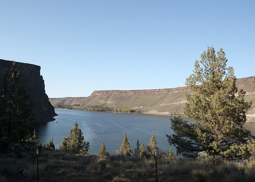
The South Jetty at the mouth of the Columbia River is a dive site that has escaped us for many years.  We have never managed to be here during the right conditions to make this dive.  However, we are pretty sure that you can dive the jetty in perfect conditions.  Someday we’re going to get this dive.  Maybe you will beat us to it!

The South Jetty at the mouth of the Columbia River is almost always a rotten place to dive but every once in a while the weather is just right and this is an enticing place to dive. Someday we’ll manage to dive here.


Site Highlights:

The main drive for us to dive here is the novelty of diving on the most northwesterly point of Oregon.  Because conditions here are almost always rough, we have never managed to get in the water.  We expect that there is good spearfishing on the jetty.  There may also be some pieces of old shipwrecks but we aren’t sure.

Nearest Town:

Warrenton, Oregon


GPS Coordinates:

46.228340, -124.019644

Special Directions to Site:

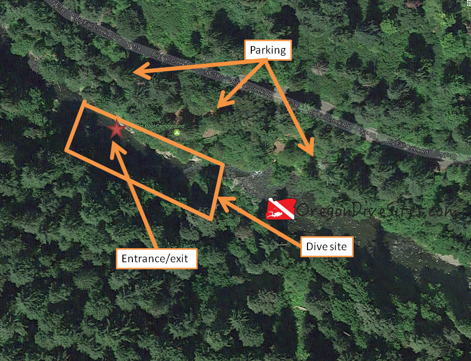
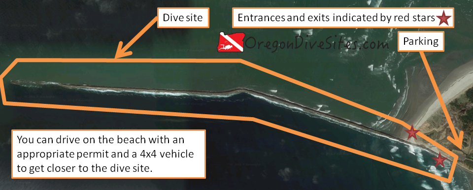
Head to Fort Stevens State Park and then follow signs for the Columbia River.  Look for Parking Lot C signs.  If you are going to drive on the beach, check locally for what permits you need (probably an Oregon OHV permit) and where access is available to get onto the beach.

If you’re accessing the jetty from a boat, the Hammond Boat Basin on the Columbia River is the closest place to put in a small boat.  Make sure you have a good captain who knows the Columbia Bar.  We know of someone who died on the bar in his small open boat.  His body was never found.  There’s a reason that the Columbia River’s mouth is part of the Graveyard of the Pacific.
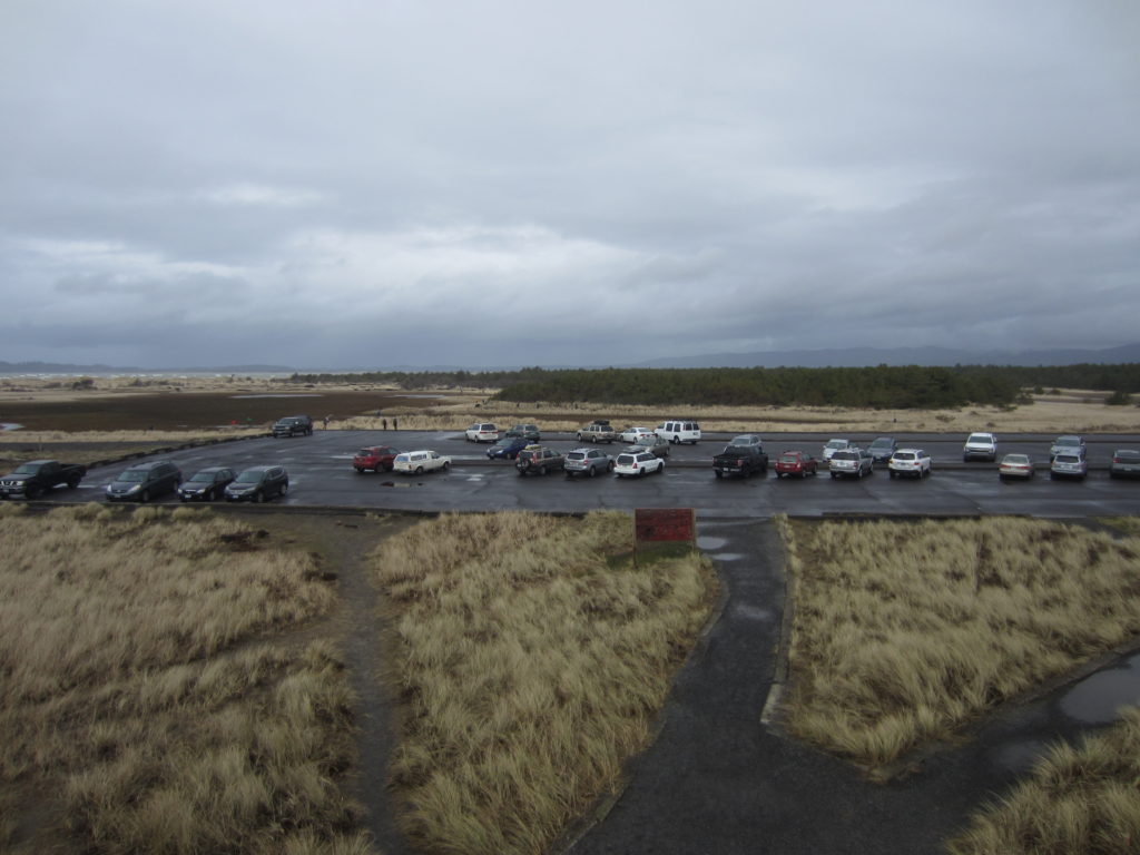
Parking:

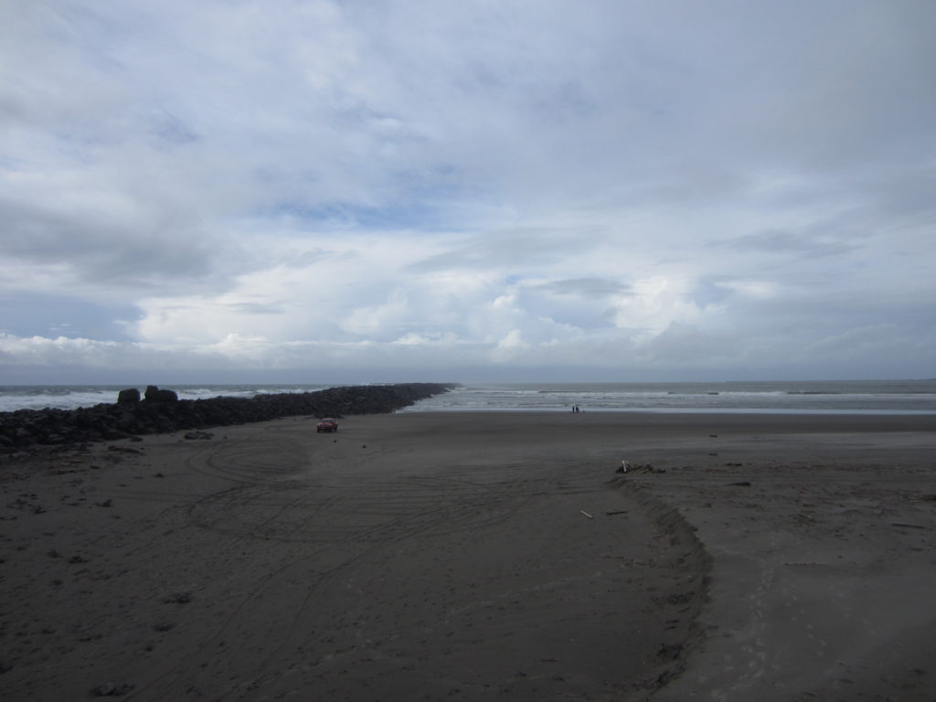
There is a big parking lot right at the base of the jetty.  Otherwise, you can drive on the beach with proper permits (Oregon OHV permit) and at the right time of year.  This will get you closer to the site.

We have not had to pay for parking at Lot C but this could change.  Make sure before you park if you need to pay or not.

fort stevens columbia river south jetty
Imagery ©2017 Google, Data SIO, NOAA, U.S. Navy, NGA, GEBCO, TerraMetrics. Map data ©2017 Google.
You have to dive this in perfect conditions or you will probably get smashed on the jetty rocks, sucked out to sea, drowned by massive breakers, or worse.

Site Orientation:

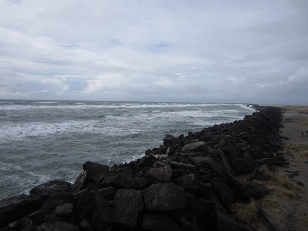
The site is mostly west-east.  You want to stick close to the rocks and not stray far away.  There can be a lot of strange currents in the area that change frequently.  The south side of the jetty is deeper than the north side close into the shore.  Farther west on the jetty, it gets deeper on both sides.

Entrances and Exits:

If you’re doing a shore entrance or exit, right at the base of the jetty is where you want to hop in.  If you drive onto the beach on either side of the jetty, the entrance will be easier than climbing on the massive jetty rocks.

If you’re doing this as a boat dive, it’s worth heading toward the tip of the jetty for deeper water.  Make sure you check out the proper nautical chart and have a good boat captain.  The tip of the jetty goes underwater and can be hazardous even in good conditions.

north side of jetty
The beach on the north of the Columbia RIver’s south jetty is very long. You will have to walk through a lot of shallow water before you find a place worthwhile to go underwater.

Salt/Fresh:

This is a salt water dive.

Shore/Boat:

The south jetty on the Columbia River can be done either as a boat or a shore dive.  When the conditions finally align with our plans, we expect we’ll do this as a shore dive.

Normal Conditions:

Normally it’s way too rough to dive here.  Every time we have tried, the conditions are rotten.  In absolutely ideal conditions, you will still have to contend with surf, surge, and current.

Normal Visibility:

Based on what we have been told by other divers and our own experience on nearby jetties, we expect visibility to range from 5 to 15 feet depending on conditions.

Normal Temperature:

This site is exposed directly to the open ocean so water temperature tracks ocean temperature.  Expect to see temperatures between 45F and 55F.

lot c
Parking Lot C is the closest you can get on pavement to the jetty. It’s a good place to stage before making the climb over the jetty or the long walk to the north beach.

Best Time of Year:

Summer and early fall when no storms are predicted is the best time to try your luck at getting a calm day at the mouth of the Columbia River.

Max Depth:

At the very tip, nautical charts show about 65 feet of water.  Along the jetty where you can dive from shore, the north side won’t get much below 15-20 feet at high tide while the south side can get up to about 30 feet.

Suggested Special Training:

You really should have rescue diver training and a lot of experience diving jetties in Oregon before you attempt this.  Even then, this can be a dangerous site.

Difficulty of Dive:

This is an advanced dive that requires lots of planning and good conditions.  Diving in anything less than ideal conditions is just asking for trouble.

Distance of Walk to Entrance:

If you park in C Lot, you’ll be walking about 300 feet plus a jetty scramble for the south side of the jetty or about 1500 feet plus a long slog through shallow water (up to 2000 feet!) for the north side of the jetty.  It’s possible the north side might have quicksand in the shallows so be very careful.

Surface Swim Length:

No surface swim is necessary on most of the south side unless you’re starting from the beach in which case you might have to swim 1000 feet for deep enough water.  On the north side, you’re looking at 1000+ feet of swimming to get to deep water.

Special Site Notes:

To dive on the beach, you need a permit (Oregon OHV).  Check locally to see what the rules are.

This site is not one that you can just go and do any day of the week.  Weather needs to be good and ocean conditions need to be calm.  Even then, the Columbia River pumps out a LOT of water and there are a lot of strange and unpredictable currents around the jetty.

Closest Local Dive Shops to Get Air Fills and SCUBA Gear:

There is a full service SCUBA shop in Astoria with air fills.

Nearby Restaurants We Like:

Look for the little tugboat on the back of a trailer in downtown Astoria for really good fish and chips.

Nearby Places to Camp and Diver-Friendly Hotels:

The state park has camping available.  We haven’t tried any of the hotels in the area.  Please let us know if you are aware of diver-friendly lodging in greater Astoria.

What Other People Have to Say About This Site:

Please write in the comments below your experiences with this dive site!

Categories
Central Cascades

Jawbone Flats – Opal Pool

Diving the Opal Pool at Jawbone Flats is a unique experience for Oregon SCUBA divers.  Opal Creek, a tributary of the Little North Fork of the Santiam River, is a gorgeous cascade of water and sparkling lush forest.   The azure waters in the Opal Pool below Opal Pool Falls are inviting in the late summer or early fall.  We have seen many people enjoying a swim here although the water can be chilly.

opal pool
The Opal Pool is a short walk up from Jawbone Flats where you can rent cabins.

Site Highlights:

The main thing we like about this SCUBA dive site is the unique experience of going diving in a gorgeous pool tucked back into the forest far away from the nearest road.  It is a unique and peaceful place to put on dive gear and take a dip.

Underwater the basalt river rocks are mostly smooth and round.  The walls of the pool are all basalt cliffs that add to the drama and beauty of this site.  Someone with a very good camera and some time could make some awesome photos here combining the underwater and the above water beauty of the opal pool at Jawbone Flats.

Nearest Town:

The nearest big city is Salem, Oregon.  The tiny hamlet of Elkhorn is the first thing you will encounter driving down from the Opal Creek Trailhead.  The bigger towns of Mehama and Lyons are a ways further down the road.

GPS Coordinates:

44.844199, -122.206503

Special Directions to Site:

It takes some time to get to Jawbone Flats and the Opal Pool.  First you need to drive to the Opal Creek Trailhead at the end of forest road NF-2209 out of Elkhorn, Oregon.  Then you need to hike up to Jawbone Flats where the Opal Creek Ancient Forest Center is located.  Then you take the trail toward Cedar Flats.   Opal pool is below the bridge not far out of Jawbone Flats.

The whole hike round trip is about seven miles.  Carrying 100lbs of SCUBA gear on your back that distance is infeasible.  There are a couple options though.  You can try talking with the center at Jawbone Flats about having them use their shuttle to bring your gear up to the center and then walk the gear from there.  You can convince a bunch of friends to help you carry in and out your SCUBA gear.  You can also try using a wheeled cart although we aren’t sure if forest regulations allow that.  We personally think staying at Jawbone Flats at the Opal Creek Ancient Forest Center overnight and coordinating with the center to bring your gear in and back out is the best option.

Parking:

You pay to park at the Opal Creek Trailhead.  On popular weekends, the trailhead can be completely full of cars so plan ahead.

opal creek overview
Imagery ©2017 Google, Map data ©2017 Google.
The round trip hike to Opal Pool is a little over seven miles but we think the trip is well worth it for the unique diving experience.
opal creek close up
Imagery ©2017 Google, Map data ©2017 Google.
Once you have hiked up to Jawbone Flats and the Opal Creek Ancient Forest Center, take the trail toward Cedar Flats. Opal Pool isn’t too far away.

Site Orientation:

Opal Pool is down in the creek bed.  The site is so small and the water is so clear that you can’t really get lost here.  Be mindful of other users of the pool.

Entrances and Exits:

It’s a bit of a scramble down to the dive site from the trail but it is manageable.  The rocks can be a bit slippery depending on conditions so watch your footing.

Salt/Fresh:

This is a fresh water dive.

Shore/Boat:

This is a shore dive.

Normal Conditions:

During the summer and fall, the water is usually fairly calm although we have seen quite a few people swimming here on hot weekends.  In the spring during the snow melt, this creek can turn into a raging torrent.  During flood conditions, you will see why it is a bad idea to try diving the site!

Normal Visibility:

Visibility at Opal Pool is usually around 20-30 feet.  You can see the bottom of the deepest part of the pool when you’re floating on the surface.

Normal Temperature:

Water temperature is influenced by recent storms, snow melt, and upstream spring volume.  We have seen it between 40F and 60F depending on conditions although the deepest part of the pool is usually colder.

Best Time of Year:

The best time of the year for making the trek to Jawbone Flats to dive Opal Creek is late summer or early fall.  The water is warmer, the flow is lower, the days are warm, and it is less likely to be rainy and misty.

Max Depth:

We found 30 feet of water at one place in the pool.

Opal Creek Ancient Forest Center
Opal Creek Ancient Forest Center at Jawbone Flats has cabins for rent and very limited food service. Both must be reserved weeks or months in advance.

Suggested Special Training:

This is an altitude dive and you should have the training necessary for altitude diving.  Open water divers can successfully dive this site although just getting to the site is challenging enough that we suggest open water divers go check out other more easily accessible sites.  Down by Eugene there are some good dives that have similar pools to Opal Pool.

Difficulty of Dive:

We rate this as an intermediate dive because of the trek to get to the site and the bit of scramble necessary to get to the water.  Also this is an altitude dive so diving around Jawbone Flats requires a little extra training.

Distance of Walk to Entrance:

It’s about 3.5 miles from the parking lot at the trailhead all the way to the dive site.  Yes, that’s a brutal hike wearing 100lbs of dive gear.  Yes, it’s a bad idea to try to do it completely geared up unless you like heat stroke.

Surface Swim Length:

No surface swims are needed at Opal Pool.

Special Site Notes:

We highly recommend contacting the Opal Creek Ancient Forest Center at Jawbone Flats several weeks or even several months in advance of your visit.  While we have gone diving at this site before and know others who have done it, the staff at Jawbone Flats has changed since then.  We view diving Opal Pool as a privilege rather than a right for SCUBA divers.  Please be polite with the staff and gracious to your hosts.

We suggest renting a cabin at the Center and asking the staff to transport your gear from your car to your cabin.  They did it for us a number of years ago.

It would be worthwhile to investigate what sorts of tasty beverages or recreational activities the staff at the Center enjoy and bringing some things up to share with them.  The staff stays in at Jawbone Flats for days or weeks at a time and, at least the last time we were there, they enjoyed us bringing in things that they can’t usually get at Jawbone Flats.

Closest Local Dive Shops to Get Air Fills and SCUBA Gear:

The closest dive shop is in Salem where air fills, gear service, and rental gear is available.  However, this dive site is inaccessible enough that you need to bring everything with you and be fully self sufficient.

Nearby Restaurants We Like:

The Opal Creek Ancient Forest Center does have very limited (but very good!) meal service.  You MUST reserve your meals at least two weeks in advance (double check this because it might change!) so that they have enough food for you.  There is usually NOT walk-up food service.  If you aren’t having a meal or two at the Center, you need to bring in all of your own food.

Nearby Places to Camp and Diver-Friendly Hotels:

The Opal Creek Ancient Forest Center has cabins for rent.  However, they are extremely popular and often booked out months in advance.

You can camp in the forest but you must follow local wilderness regulations.  This area gets a lot of use so check with the district ranger office well in advance of your trip to get the most up-to-date information on where you can camp.  In addition to  being against forest regulations to camp wherever you want, it is also very bad for the forest if you camp in places that you shouldn’t.  The Opal Creek Wilderness is a special place in Oregon that as SCUBA divers we should work to protect so that we can continue enjoying Jawbone Flats and the Opal Pool for many years to come.

What Other People Have to Say About This Site:

Please write in the comments below your experiences with this dive site!

Categories
Central Oregon

Lake Billy Chinook – The Cove Palisades State Park – Upper Deschutes Boat Launch

The Upper Deschutes Boat Launch at Lake Billy Chinook is a fun place to go diving in central Oregon.  There are some interesting underwater rock formations along the submerged cliff walls but the site also has good areas for shallower diving depending on what you’re looking for in a SCUBA adventure.

029_view_odfw
Lake BIlly Chinook. Photo by the Oregon Department of Fish and Wildlife. Copyright 2009.

Site Highlights:

We like this site for the interesting submerged cliffs and underwater rock formations.  There are also some good areas to practice SCUBA skills near the shore.  Diving in Lake Billy Chinook is not something most people from the west side of the Cascades would usually but it is worth the drive to Central Oregon to test the waters.

Nearest Town:

The nearest large town is Bend with Redmond in between.  Culver and Metolius are both closer although they are smaller towns.

GPS Coordinates:

44.532684, -121.291513

Special Directions to Site:

Follow the signs to The Cove Palisades State Park and then look for the turn-off for the Upper Descutes Boat Launch and Day Use Area.

Parking:

There is ample parking at this site.  The last time we were here, we did need to pay for parking although this may change based on the time of year.  There are two parking areas to choose from.  One is designated for boat trailer parking and the other is for car parking.  The Upper Deschutes Boat Launch is right by the trailer parking while the day use area is by the car parking.

deschutes upper boat launch
Imagery ©2017 Google, Map data ©2017 Google.
The Deschutes upper boat launch and day use area is a big dive site that could be explored across multiple dives.


Site Orientation:

The Deschutes Upper Boat Launch and day use area could be considered two sites.  Certainly there is enough underwater ground to cover that the site merits at least two dives.  On the southwest side of the dive site where the boat launch is located, the submerged cliffs fall away rapidly from the bank.  At the northeastern part of this dive site, SCUBA divers will find a more gently sloping bottom around the roped off swimming area.

We found this site to be the most fun by starting at the southwest entrance and swimming along the submerged canyon walls until we came out at the northeast exit.  Swimming the opposite way you may encounter a very gentle current from the Deschutes River.

Entrances and Exits:

The three easiest places to enter and exit are at the boat ramp (one entrance/exit) and by the day use swimming area (two entrances/exits).  Around the boat ramp, be sure to watch for boat traffic and give way to other users of the upper Deschutes boat launch area.

Salt/Fresh:

This is a fresh water dive.

Shore/Boat:

This is a shore dive although we have SCUBA buddies who have done this as a boat dive.

Normal Conditions:

There can be some waves from boat wakes but otherwise conditions are usually pretty mild at the upper Deschutes boat launch.  Water level in the lake can vary throughout the year so be prepared for low or high water.  Depending on when you go, the amount of boat traffic at the boat launch might be too great for you to safely enter or exit the water there.

Normal Visibility:

Visibility is usually in the 20-30 foot range except around the swimming area where it can be much less when swimmers stir up the bottom.

Normal Temperature:

Temperature varies throughout the year based on snow melt feeding into the reservoir and how much energy the sun has pumped into the lake.  We have found a surface thermocline at this site of 60F and deeper water temperatures of 40F.

Best Time of Year:

We like diving this site in the early fall after most of the weekend boat traffic has left the lake and before snow starts falling in the Cascades.  However, the site is accessible most of the year (although sometimes parking is not).

Max Depth:

We never went past 75 feet here but you can go much deeper if you head out toward the old Deschutes river bed at the bottom of the flooded canyon.  Watch your depth gauge and remember that this is an altitude dive.

Suggested Special Training:

Open water divers with experience diving walls can do this site.  However, this is an altitude dive so you should have altitude diver training.

Difficulty of Dive:

We rate this as an intermediate dive for a few different reasons.  First, the boat traffic in the area makes it more challenging to stay safe.  Second, the underwater rock walls that you will be diving along can be tricky to dive if you haven’t had that experience before because you can easily go too deep or accidentally surface.  Third, this is an altitude dive and requires altitude diver training.  Fourth, the walks to entrances and exits can potentially be very long.

Distance of Walk to Entrance:

Depending on the time of year and how much boat traffic there is at the upper Deschutes boat launch, you may be walking from a long way away.  Expect at least a 200 foot walk from the closest parking to the boat ramp and plan for possibly 800 feet of walking.  One approach is to assemble your gear in one of the parking areas, drive it as close as possible to the entrance you want to use, drop your gear off, go park, walk back, don your gear, and enter the water.  Upon surfacing, doff your gear where you can pull up a car, go walk to your car and bring it to your gear, load up your gear, and take it somewhere else to break down.

The lengthy walks convince some people to dive this site using a boat.

Surface Swim Length:

No surface swim is needed here.

Special Site Notes:

Be mindful of boaters using the boat ramp.  We always give boaters priority when we use a boat ramp as an entrance or exit.  Several times at different boat ramps across Oregon, we have made friends by helping boaters recover lost equipment that took a swim after falling overboard at the ramp.

Because of all of the boat traffic in this area, it is a very good idea to have a dive flag and use it.  We have a dive flag that we highly recommend on our Gear We Use page.

Remember that this is an altitude diving site and you should have training to dive at altitude.

It is easy to go too deep at this site.  Watch your depth gauges carefully.

[Underwater Map of Dive Site Coming Soon!]

Closest Local Dive Shops to Get Air Fills and SCUBA Gear:

There is a dive shop in Bend that does air fills, services gear, and has gear for sale.

Nearby Restaurants We Like:

We haven’t tried any of the restaurants in the area although we know there are some places to eat in the nearby towns.  Please let us know if you have a favorite place to get food!

Nearby Places to Camp and Diver-Friendly Hotels:

There are some state and federal campgrounds in the area, and over on the Crooked River branch of Lake Billy Chinook there is a resort with cabins for rent.  Please let us know if you have a favorite place to camp around the upper Deschutes boat launch that is SCUBA friendly!

What Other People Have to Say About This Site:

Please write in the comments below your experiences with this dive site!

Categories
Central Oregon Coast

Oregon Coast Aquarium – Orford Reef

If you get the opportunity, definitely go dive the Orford Reef tank at the Oregon Coast Aquarium.  Aside from being a unique SCUBA diving experience in Oregon, it is a lot of fun to wave at people who are inside the underwater tube.  Some divers have friends visit the aquarium when they’re diving so they have someone to wave at in the tube and the person in the tube can take photos of them diving.  This is an outstanding way to share your passion for and love of SCUBA diving with friends who don’t dive.

orford reef tank
The Orford Reef tank is the most challenging of the tanks at the Oregon Coast Aquarium to dive. Only very skilled divers are allowed to go in this tank. The tank is tight compared to the others.

Site Highlights

The biggest highlight for us is to wave at people on the other side of the glass.  This tank used to be where Keiko the killer whale from Free Willie fame lived for several years before heading to Iceland.  Now Keiko’s big tank has been broken up into several smaller tanks that each represent an ecosystem found off the Oregon coast.

There are a lot of interesting fish in this tank.  The water is so clear that it is very easy to watch the fish lazily go by.  These tanks have divers in them at least once a week for cleaning so the marine life is used to seeing people on SCUBA.

Nearest Town:

Newport, Oregon is right outside the door.

GPS Coordinates:

44.616561, -124.045709

Special Directions to Site:

When you schedule your diving experience at the Oregon Coast Aquarium, they will give you details on where to go and who to talk with so that you can get in the tank.

Parking:

The aquarium will tell you where to park.  When we went, we parked in the normal parking lot although our friends who regularly dive the tanks as volunteer cleaners park elsewhere.

Site Orientation:

The tank is divided into two parts by the big clear tube that runs across the middle.  This is a tiny tank compared to what we are used to out in the open water.  You can see the whole tank in a couple minutes but playing around waving at people in the tube can occupy at least a half hour.

Entrances and Exits:

We used a ladder to get into the tank.

Salt/Fresh:

This is a salt water dive.

Shore/Boat:

This is a shore dive.

Normal Conditions:

There are never really waves or surge in this tank.  It’s very benign.

Normal Visibility:

You can see all the way from one side of the tank to the other side of the tank.  That’s about 30-40 feet.

Normal Temperature:

Water temperature is usually close to the temperature in Yaquina Bay.  When we went diving, it was about 45F.

Best Time of Year:

It used to be that you could only dive the Orford Reef tank when a DUI Drysuit Days event was going on as a private individual.  That usually happens once per year although we haven’t seen an announcement for an upcoming DUI event at the Oregon Coast Aquarium in a couple years.

A Eugene-based shop now works with the aquarium to arrange private diving events in the tanks.  We have not gone on one of these events but we did dive through one of the regional shops that used to participate in the DUI Drysuit Days events in the past.  Note that they currently do not advertise being able to dive in the Orford Reef tank.  When we went with the DUI Drysuit Days program a few years ago, due to our extensive diving experience in Oregon and around the world, the aquarium staff and volunteers put us in the Orford Reef tank because the other tanks were full of people.  Perhaps if you ask nicely, you can pay to dive Orford Reef.

Otherwise, you can volunteer as a tank cleaning and maintenance diver.  We know a couple people who do this and head out to Newport about once a month for a weekend of cleaning tanks.  They both have been doing it for years so it must be fun!

Max Depth:

Our gauges read 25 feet at one point.  Most of the time you’ll be between 10 and 20 feet.

Suggested Special Training:

Open water divers can do this dive.  However, we only got the chance to do this dive because we have extensive training in both recreational and scientific diving, and have thousands of dives under our weight belts in a wide range of conditions all around the world.

We suggest that if you wish to pay for the opportunity to dive Orford Reef, you contact the aquarium or the dive shop running the program and see what training and experience you need to be permitted into Orford Reef.  We think it’s worth the extra effort to dive this tank.

Difficulty of Dive:

The dive itself is straight forward and not that difficult if you are aware of your surroundings.  However, we only had the opportunity to hop into this tank because of our extensive training and experience.

There are overhead hazards associated with the clear tube that aquarium visitors walk through.  The tank is also tight and requires finesse in navigating the close-together walls.  If you are claustrophobic, you probably don’t want to hop in this tank.  With three of us in the tank, there wasn’t much room.  The aquarium was very serious about our neutral buoyancy skills and had us demonstrate them in the medical tank behind the Halibut Flats tank before letting us into Orford Reef.

For these reasons, we rate this as an advanced skill level dive.

orford reef tank
The Orford Reef tank is a tight place to dive but it’s quite the fun experience.

Distance of Walk to Entrance:

We had to walk about 100 feet from where we geared up, climbed some stairs to the top of the tank, and then descended a ladder into the tank.  You need to be somewhat nimble to get into the tank and out again safely.

Surface Swim Length:

No surface swims here!

Special Site Notes:

Contact the aquarium and the dive shop that supports the aquarium to talk about diving Orford Reef.  It is not normally a tank that divers who are not volunteers at the aquarium get to use.

Be sure to have some friends at the aquarium to take photos of you from outside the tank.  We took a small action video camera in the tank with us to take some videos which was fun to have.  There isn’t much room to maneuver a big camera rig in here so we suggest not bringing anything bigger than a small action cam.

Closest Local Dive Shops to Get Air Fills and SCUBA Gear:

There is a local dive shop in the South Beach area of Newport. When we went diving here, the aquarium supplied us with tanks and weights.  We had to wash all of our gear before we could use it in the tank to make sure we didn’t transport any nasty creatures into the tanks.

Nearby Restaurants We Like:

Both sides of the Yaquina Bay in Newport sport a variety of great restaurants.

Nearby Places to Camp and Diver-Friendly Hotels:

South Beach State Park has good camping and yurts for rent.  We stay here when we’re in Newport.  We have not tried any of the local hotels.  Please let us know if you have and you can recommend one that is SCUBA diver friendly!

South Beach State Park has great yurts that SCUBA divers can rent. The heaters in the yurts really are nice after a long day of diving around Newport.

What Other People Have to Say About This Site:

Please write in the comments below your experiences with this dive site!

Categories
Central Cascades

Smith Reservoir – Dam Boat Ramp

The dam boat ramp at Smith Reservoir is an easy entrance and gives quick access to the deep cold waters of Smith Reservoir.  However, the water intake structure for the Eugene Water and Electric Board is nearby and divers should use caution to not go near it.  The water is deep and cold enough here to make a regulator free flow as well due to ice buildup.

Underwater at Smith Reservoir.
Diving at the dam boat ramp at Smith Reservoir allows you to go deep in a hurry where low light and cold water make the diving a little more challenging. Huge old stumps from when there used to be an old growth forest here are a highlight.

Site Highlights

The reasons for people diving at the dam boat ramp on Smith Reservoir are mainly because the entrance is easy, you can go deep quickly, and there are big old stumps underwater to check out.  This is a typical Oregon Cascades lake or reservoir dive site with very cold water at depth, low viz if you stir up the bottom, and isolation from other humans.

Nearest Town:

There are no nearby towns.  Eugene, Bend, and Salem are equally far away.  There is a lodge at Clear Lake with a few basic services.

GPS Coordinates:

44.309534, -122.043461

Special Directions to Site:

Parking:

There is ample parking around the boat ramp but be sure to leave the ramp itself and the boat trailer parking clear for people with boats.  The last time we were here, we did not have to pay to park although this may change in the future.

smith reservoir dam boat ramp dive site
Imagery ©2017 Google, Map data ©2017 Google.
The farther west you go, the deeper it gets until you exceed maximum recreational dive limits. The water intake structure south of this dive site is to be avoided.

Site Orientation:

This site is more or less aligned to the cardinal directions.  The shore runs roughly north-south.  Head east to find your exit.  Head west to find very deep water.  Be careful of going too far south.  You want to avoid the water intake structure so you don’t end up sucked to an untimely death in the hydro electric project.

Entrances and Exits:

The best part of this site is how easy the entrance and exit is.  Just walk down the boat ramp and into the water!  Easy!  Do be mindful though of boater traffic and the occasional angler.

Salt/Fresh:

This is a freshwater dive unless someone dumps a LOT of salt in the lake.

Shore/Boat:

This is a shore dive although you could practice your boat diving skills here.

Normal Conditions:

This site is usually pretty calm.  It’s a good idea to have a dive flag since you’re near an active (although seldom used) boat ramp.  We recommend a dive flag on our Gear We Use page that we have used all over Oregon and are very happy to have in our inventory.

It can get really dark at depth at this dive site, especially if the sun is not directly overhead.  A good dive light is a good idea.

Normal Visibility:

15-20 feet of viz is the norm here although during spring snow melt or heavy rainstorms, the viz can be much lower.  The bottom can be stirred up and lead to greatly reduced viz so practice good neutral buoyancy skills.

Normal Temperature:

At the surface it can easily hit 60F in the summer but at depth, the water can be 38F all year long and even colder when the snow is melting.  We had a regulator free flow at the other dive site at Smith Reservoir a few years ago because the water was so cold.

Best Time of Year:

Summer and early fall are the best times to go diving here.  In the winter and spring, snow makes this site usually inaccessible or miserably cold to dive.

Max Depth:

We have gone down to 100 feet here where we had a regulator free flow due to ice buildup.  You can go MUCH deeper if you want to or if you aren’t careful about watching your gauges.

Suggested Special Training:

This is an altitude dive site so you should have altitude diver training.  Open water divers can successfully dive here as long as you have altitude training.

Difficulty of Dive:

The entrance and exit are easy and most of the diving is easy.  However, because you can easily go way too deep if you aren’t paying attention, we rate this as an intermediate dive site.

Distance of Walk to Entrance:

The most we have ever had to walk is 100 feet at this dive site.  If you can’t walk very far to an entrance, you could setup your gear right at the water’s edge and have someone move your car back up the boat ramp to the parking area.

Surface Swim Length:

No surface swim is needed here.

Special Site Notes:

This is an altitude dive site.  Beware of the water intake structure close to the dam.  The dam boat ramp is far enough away from the intake structure that you would have to either be very inattentive or actively try to get near it to be in danger but there is a danger that you could get sucked into it.

The water at depth is very cold and can cause your regulator to free flow due to ice formation.  We had it happen to us once at the other dive site on Smith Reservoir.

[Underwater Map of Dive Site Coming Soon!]

Closest Local Dive Shops to Get Air Fills and SCUBA Gear:

There are no close shops to Smith Reservoir’s dam boat ramp.  The closest shops are in Salem, Eugene, and Bend.

Nearby Restaurants We Like:

There is limited food service at the lodge at Clear Lake.

Nearby Places to Camp and Diver-Friendly Hotels:

There is camping at Trail Bridge Reservoir’s campground and plenty of primitive camping in the forests.  If you have a boat, there is a campground accessible only by boat or hiking at the north end of the lake.  At Clear Lake there is a lodge that rents cabins.

What Other People Have to Say About This Site:

Please write in the comments below your experiences with this dive site!

Categories
Central Cascades

Smith Reservoir – Upper Car Turnaround

The upper car turnaround at Smith Reservoir is a good place to go if you want underwater terrain that is a little less steep than near the dam on Smith Reservoir.  At this site you will see big algae mats near the surface and big stumps all over the place underwater.  It’s common to see trout cruising by here, too.

Smith Reservoir
Looking toward the dam on Smith Reservoir from the upper car turn-around dive site. This lake does get boat traffic occasionally so a dive flag is a good idea.

Site Highlights

The main highlight on this site is the big underwater stumps.  Old growth trees were cut down to make way for Smith Reservoir.  The stumps are big and plentiful as you go down the underwater slope.  This is also a good place to practice your diving skills at a little more forgiving of a site than somewhere like Clear Lake.  The walk from where you can park your car down to the water is somewhat challenging and can give good practice for doing more demanding entrances on the Oregon coast.

Nearest Town:

There aren’t any towns out here.  The nearest humans will probably be at the lodge at Clear Lake.  Otherwise Bend, Eugene, and Salem are all about the same distances away.  You need to be self sufficient at Smith Reservoir.

GPS Coordinates:

44.314719, -122.043345

Special Directions to Site:

Watch for the signs for NF-730, Tamolitch Trailhead, Smith Reservoir, and Trail Bridge Campground along the McKenzie River Highway.  The turn comes up fast so give yourself plenty of time to slow down and make the turn.  Once you cross the bridge, go left and drive past the big water turbine power generator.  There is a payphone here that worked the last time we checked.  There is no cell service here otherwise.

You will drive past the top end of Trail Bridge Reservoir (there are several dive sites at Trail Bridge Reservoir) and then head up a canyon before climbing up the face of Smith Reservoir Dam.  Keep driving along the east shore of the lake until you get to the dead-end and turn around.  This is the dive site parking area.

Parking:

The turn around at the end of the road has some areas that you can park at.  Be sure to not block the turn around so that other people can turn their vehicles around here.  The last time we were here, there were no signs or other indications of having to pay to park but this could change.

smith reservoir
Imagery ©2017 Google, Map data ©2017 Google.
The turn around area at the end of the road above the dam at Smith Reservoir is big enough to turn a trailer around.


Site Orientation:

The site is laid out on the compass points.  North heads to the shallow headwaters of Smith Reservoir while south heads toward the Smith Reservoir Dam.  West sends you to deep water and east sends you to shore and your car.

Entrances and Exits:

There are several decent entrances and exits along the shore.  You do have to take some big steps to get into the water which can be exacerbated by water level in the reservoir.

Salt/Fresh:

This is a fresh water dive.

Shore/Boat:

This is a shore dive although you could throw a boat in this lake and practice your boat diving skills.

Normal Conditions:

We have never encountered any waves or current here.  Occasionally someone puts in a kayak, canoe, or motorboat so be sure to fly a dive flag.  We have a highly recommended dive flag on our Gear We Use page.  Water can be pretty cold though during spring snow melt.

Normal Visibility:

We have found visibility to be between 5 and 20 feet depending on the time of year and how much runoff is coming into Smith Reservoir.  The bottom can get stirred up so be sure to practice good neutral buoyancy skills.

Normal Temperature:

Normally you’ll find water in the 45-55F range depending on where in the water column you are.  In the spring, it can be much colder due to snow melt.

Best Time of Year:

Summer and fall are ideal conditions.  Once the snow starts to fall, this dive site is inaccessible.

Max Depth:

You can either stay shallow or go deeper here.  We have been down to 60 feet at this site on Smith Reservoir but you can go significantly deeper if you head west and south.  Watch your max depth and remember that this is an altitude dive.

Suggested Special Training:

Open water divers can successfully dive here.  However, this is an altitude dive site and you should have altitude diver training before you go diving here.

Difficulty of Dive:

The diving itself is easy.  Getting down to the dive site from the parking lot is more challenging.  We rate this as a beginner skill level dive site but be aware that it is a bit challenging to walk down to the water.  The other dive site at Smith Reservoir might be a better option if you don’t want a strenuous walk.

Distance of Walk to Entrance:

250 feet unless the water is really low.

Surface Swim Length:

No surface swim needed.

bubbles
The water can be very clear in the right conditions at Smith Reservoir although usually the viz is around 15-20 feet.

Special Site Notes:

Remember that this is an altitude dive and you should have special training to dive at altitude.  Stay well clear of the water intake structure near the Smith Reservoir dam.  A flashlight (we have several we use and recommend on our Gear We Use page) is a good idea if you’re going deeper than about 30 feet.

We had a regulator build up ice at depth at this site and free flow on us once.  Because of the cold water and the depth you can achieve at the west and south parts of this dive site, there is the very real potential for a regulator free flow.

[Underwater Map of Dive Site Coming Soon!]

Closest Local Dive Shops to Get Air Fills and SCUBA Gear:

There are no close dive shops up at Smith Reservoir.  You need to be self sufficient.  There are shops in Bend, Salem, and Eugene.

Nearby Restaurants We Like:

The closest food of any kind is at the lodge at Clear Lake.

Nearby Places to Camp and Diver-Friendly Hotels:

The lodge at clear lake has some cabins for rent.  Otherwise there is a campground at Trail Bridge Reservoir just down the hill from Smith Reservoir or there is plenty of primitive camping in the area.

What Other People Have to Say About This Site:

Please write in the comments below your experiences with this dive site!

Categories
Central Cascades

Waldo Lake Shadow Bay Day Use Area Boat Ramp

The Shadow Bay Day Use Area Boat Ramp on Waldo Lake is a fun and easy place to go diving on the lake.  This is a big, clear body of water that has excellent visibility although at this particular site there isn’t that much to see.  We like diving here with SCUBA friends to take photos of one another goofing around underwater.  It is also neat to watch sailboats pass overhead on the surface from 50 feet down.

Waldo Lake
Photo by Coulee at English Wikipedia (Own work) [Public domain], via Wikimedia Commons. Waldo Lake is a fun place to go diving because of the great visibility and easy diving conditions.

Site Highlights:

The main thing we like about this dive site is the visibility.  Aside from Clear Lake, there aren’t that many places in Oregon where you can go diving so easily and get such great viz.  We like taking photos of each other underwater here and we also enjoy watching the hulls of sailboats glide past from the bottom.

Nearest Town:

Oakridge, Oregon is down the highway by a half hour or so from Waldo Lake.

GPS Coordinates:

43.691354, -122.042806

Special Directions to Site:

Look for signs to Waldo Lake on Highway 58.  National Forest Road 5897 is the road you want.  Follow the road for a few miles until you reach National Forest Road 5896.  There should be a Shadow Bay sign at the left turn.  Follow signs for the boat ramp.

Parking:

Parking usually isn’t a problem at the boat ramp area.  On really busy summer days, you may have to park over in the campground day use area.


shadow bay
Imagery ©2017 Google, Map data ©2017 Google. Shadow Bay starts shallow but gets very deep when you exit the little bay by the boat ramp.

Site Orientation:

The little bay next to the boat ramp is shallow.  Depending on your inclination, you can start diving here or you can surface swim out to the deeper water.  The larger part of the dive site can get very deep.  We went as deep as 70 feet here before.  It is important to use a compass and have good navigation skills because it is easy to get disoriented in the deeper water where there are no underwater landmarks.

Entrances and Exits:

We usually walk right in at the boat ramp but you can also enter from the shore along the lake if you don’t mind a little bit of a scramble to get in.

Salt/Fresh:

This is a fresh water dive.

Shore/Boat:

While we usually dive this site as a shore dive, you can also dive the entire lake as a boat dive.  Recently the Forest Service has begun allowing electric motors on the lake after many years of banning all engines.  Even with electric motors being allowed, most people still use sailboats here.

Normal Conditions:

Conditions here are usually good.  There isn’t any current to speak of.  Just watch for boat traffic when you surface.  We suggest taking along a dive flag so that boats can spot and avoid you.  We recommend the dive flag that we use on our Gear We Use page.

Normal Visibility:

Visibility is usually at least 40 feet and sometimes in excess of 100 feet.

Normal Temperature:

In the summer, water temperature around the boat ramp can be 65F.  At greater depths, expect water temperatures around 40-45F.

Best Time of Year:

This site is only accessible in the summer and fall.  Snow in the winter and spring blocks the road.

Max Depth:

We have not gone past 70 feet here although it appears you can easily go below the maximum recreational SCUBA diving depth limit on the western side of the Shadow Bay dive site.

Suggested Special Training:

This lake is an altitude dive.  Shadow Bay is at 5400 feet above sea level making it one of the higher lakes that you can dive in Oregon.  Be sure to know what you’re doing with your altitude tables and be sure your computer compensates for altitude before diving here.

Aside from the altitude diver training requirement, this dive site is very accessible to just-certified open water divers.

Difficulty of Dive:

This dive is very easy aside from needing to remember about altitude considerations.

Distance of Walk to Entrance:

Depending on where you park and where you enter, you will walk between 50 and 500 feet.

Surface Swim Length:

You don’t strictly need to surface swim here although swimming out of the little bay where the boat ramp is will conserve air for the deeper areas further to the west.  You might want to surface swim about 300 feet.

Special Site Notes:

Remember that this is an altitude dive.  The bottom on the western side of the site slowly drops deeper and deeper.  Watch your gauges and your depth.  It is very easy to be lured deeper than you intended to go because there aren’t any visual cues.

[Underwater Map of Dive Site Coming Soon!]

Closest Local Dive Shops to Get Air Fills and SCUBA Gear:

The closest dive shops are in Eugene and Bend.  This site is in the middle of nowhere and you need to be self sufficient to dive here.

Nearby Restaurants We Like:

There aren’t any restaurants nearby.  Bring your own food!

Nearby Places to Camp and Diver-Friendly Hotels:

There are many National Forest campgrounds and many opportunities for primitive camping in the area.

What Other People Have to Say About This Site:

Please write in the comments below your experiences with this dive site!

Categories
Central Cascades

Big Pool Swimming Hole on Fall Creek

Big Pool on Fall Creek outside Eugene, Oregon is a fun dive site perfect for a lazy summer or early fall afternoon SCUBA session.  We have heard this site also called Ye Olde Rope Swing Hole although that name seems to have fallen out of favor in the last few years.  Many divers in Oregon would never think to go dive a swimming hole on a creek in the Central Cascades.  We have done it and we can say it’s pretty fun.

fall creek
Fall Creek from the Unity Covered Bridge a ways below Big Pool Swimming Hole.


Site Highlights

This site is fun to dive.  There isn’t any big highlight other than it’s just plain fun to scramble down the bank and go diving somewhere people usually swim.  We have found glass pipes, a variety of beverage containers, and sunglasses in the bottom of Big Pool.  This is also a good place to go after crayfish.  We caught a pile here once with nothing more than our mesh bag (we have a mesh bag we highly recommend our Gear We Use page) and our hands.

With being so shallow, you can spend a long time diving this site.  Going slow along the bottom looking for things lost by swimmers can be a lot of fun.

Nearest Town:

The little town of Lowell, Oregon is just down the road.  Eugene and Springfield are a little further away and much larger.

GPS Coordinates:

43.966372, -122.600530

Special Directions to Site:

Head up the Willamette Highway and then follow signs for Lowell.  Take Moss Street north out of Lowell (it becomes Jasper-Lowell Road) and then turn right onto Big Fall Creek Road.  Go through the little community of Unity and head upstream above the dam and Fall Creek Lake.  Look for signs for Big Pool Campground.

Parking:

Usually you can squeeze into the Big Pool Campground parking area or nearby by pulling off the forest road.  Don’t block other people in.

big pool
Imagery ©2017 Google, Map data ©2017 Google. Big Pool is a fun place to do a dive not far from Eugene.

Site Orientation:

You might encounter a bit of current depending on the time of year and how much water is flowing down the creek.  Upriver is against the current and downriver is with the current.  The site isn’t very large so you don’t have to worry about getting lost.

Entrances and Exits:

You have to walk down a bit of a scramble of a bank from the campground area to get to Big Pool.  We had to walk through someone’s campsite the last time we were here.  the Forest Service may have improved the campground since last we went diving at Big Pool.

Salt/Fresh:

This is a fresh water dive.

Shore/Boat:

This is a shore dive.

Normal Conditions:

Usually there is a tiny bit of current but nothing bad.  Conditions here are benign unless you’re diving during the big spring snow melt.  When the thaw is on and the creek is raging, Big Pool might be a bit too much for most people to dive.

People like swimming in Big Pool.  Be mindful of other users of the SCUBA dive site.  People also like to jump into the water from a few different overhanging areas.  It might not be a bad idea to have a friend stay on the surface to keep people from jumping on top of your bubbles while you are trying to surface.

Normal Visibility:

As long as you stay off the bottom, you can get 15 feet of visibility here.  If you stir up the silt on the bottom, it’s easy to go down to 3 feet of viz.

Normal Temperature:

At the end of summer, water temperatures can be up around 65F.  During the spring snow melt, it can be around 34F.

Best Time of Year:

The summer and fall are the best times to dive this site but it can be accessed most of the year as long as the road is open and not covered in snow.

Max Depth:

We found 25 feet here once but most of the site is shallower than that.

Suggested Special Training:

Open water divers can dive this site without too much problem.  This site is just below 1000 feet so by the training standards we are familiar with, this does not count as an altitude dive.  If you go further up Fall Creek, you will get into altitude diver territory.

Difficulty of Dive:

This is an easy dive.  The hardest part is the scramble down and up the bank.

Distance of Walk to Entrance:

About 100 feet unless you get really unlucky with parking.

Surface Swim Length:

No surface swim at Big Pool!

Special Site Notes:

Please be considerate of other users of this site.  People come here to relax, swim, chill out, and have a good time.  Talking with other site users before you go diving can go a long way to improving relations between SCUBA divers and the public.

[Underwater Map of Dive Site Coming Soon!]

Closest Local Dive Shops to Get Air Fills and SCUBA Gear:

There is a local dive shop in Eugene with full service gear repair, sales, and air fills.

Nearby Restaurants We Like:

We haven’t tried any of the restaurants in this area so please let us know if there is one we should check out!

Nearby Places to Camp and Diver-Friendly Hotels:

There are many campgrounds in this area including right at the dive site.  There are also primitive camping opportunities.  We haven’t tried any of the area hotels so please let us know if you find a hotel that is SCUBA diver friendly.

What Other People Have to Say About This Site:

Please write in the comments below your experiences with this dive site!

Categories
Central Oregon

Lake Billy Chinook – The Cove Palisades State Park – Crooked River Boat Ramp

The Crooked River Boat Ramp at Lake Billy Chinook is a good place to go get wet in Central Oregon.  You can either do this as a shore dive or a boat dive depending on if you bring a pontoon or motorboat with you.  The site varies from a fairly shallow and sandy bottom to deep, steep, and rocky.  There is a fair amount of boat traffic in the summer around the boat ramp but there are plenty of other places to enter and exit the water nearby for shore diving.  We have had a good time searching for objects lost by boaters at the boat ramp.  More often than not, it seems that there is a boater with something that just fell overboard who is very happy to see a couple SCUBA divers in the parking lot.

Lake Billy Chinook and Mt. Jefferson
Copyright 2009 Sarah McDevitt. Lake Billy Chinook has a lot of potential for SCUBA diving if you have a boat. The Crooked River Boat Ramp is a good place to put your boat in or to shore dive.

Site Highlights:

The draw for us to dive around the Crooked River Boat Ramp is the underwater topography.  While the swimming area and directly around it are relatively shallow and sandy, going to either the north or south you will encounter steep underwater cliffs that are fun to explore.  Taking a boat farther out into the lake opens up many potential dive sites that we haven’t been able to explore yet.

Nearest Town:

Culver and Metolius, Oregon are the two closest small towns.  Redmond and Bend are further south and have more services.

GPS Coordinates:

44.554023, -121.262217

Special Directions to Site:

From US 97, follow signs for Lake Billy Chinook and The Cove Palisades State Park.  You’ll end up on SW Jordan Road as you descend into the canyon.  Right after the switchback at the bottom, the marina is on the right and clearly signed as the Crooked River Boat Ramp.

Parking:

Parking is plentiful although it fills up on weekends in the summer.  Be sure to park in the lot that is appropriate for your vehicle.  Don’t take up a boat trailer spot with your car.  The last time we were here, we paid to park but that may have changed.

Imagery ©2017 Google, Map data ©2017 Google. The Crooked River Boat Ramp has a lot of good entrances and exits, and varied terrain that keeps this dive site interesting.


Site Orientation:

The site runs roughly north-south.  The further to the west you go, the deeper it gets.  We haven’t gone beyond 75 feet deep at this site although the depth finder on our boat indicated that out in the old river channel, you can surpass the maximum recreational SCUBA diver depth limit.

Around the boat ramp and swimming area, the bottom is mostly flat and sandy.  This is a shallower area that is appropriate for practicing your SCUBA skills.  To the north and south, the water gets deeper and the terrain gets more rugged and rocky.  We have found big boulders underwater that must have plunged down centuries ago from the basalt cap rocks on the mesas high above.

Be sure to steer clear of the boat ramp and docks when boaters are present unless you’re helping a boater retrieve lost gear.

Entrances and Exits:

There is an entrance and an exit for everyone here.  Most of the entrances are easy walk-ins.  A few you have to do some big steps down to the water.  At the boat ramp, someone with limited ability can walk right into the water.

Salt/Fresh:

This is a fresh water dive.

Shore/Boat:

The Crooked River Boat Ramp can be dived as a shore dive or a boat dive depending on what you want to do.  If you’re doing a boat dive, we suggest you head further north along the lake and check out some of the cliffs up in that direction.  The entire lake is diveable although you need to check with local regulations to see if SCUBA divers are allowed everywhere.

Normal Conditions:

You sometimes can get a little wake from boaters coming into the marina too fast.  Otherwise, there can be a little current to the west of this dive site if the Crooked River is running high during the spring snow melt.  Beyond that, this is a pretty benign dive site compared to diving on the Oregon coast.

Normal Visibility:

The last time we went diving here, we easily had 50 feet of visibility although during the end of the summer when water quality can be very poor, the viz can go much lower.

Normal Temperature:

We have seen water temperatures as cold as 38F at depth and as warm as 60F in the shallows here.

Best Time of Year:

In the summer, the lake is packed with boats which makes it a little more tricky to dive around the Crooked River Boat Ramp.  However, the air and water are warmer and all of the concessions along the lake are open.

In the winter, we have heard that the gate to this site sometimes is closed although we have not had that problem ourselves.

This site is diveable all year round.  Choose your favorite time of year to go to Central Oregon and head to Lake Billy Chinook!

Max Depth:

We haven’t gone past 75 feet at this site although you should be able to touch 130 feet without too much effort to the west of the site.

Suggested Special Training:

Open water divers can dive this site after taking an altitude specialty class.  The lake elevation is usually around 1900 feet above sea level making this an altitude dive.

Difficulty of Dive:

This is an easy dive site that can be enjoyed by everyone assuming that you have altitude diver training.  Entrances and exits are very easy.  There is even handicapped parking right next to the boat ramp.  If you want a little more challenge, go either north or south along the canyon walls to find underwater cliffs and deep water.

Distance of Walk to Entrance:

Depending on where you park, it can be between a 50 foot and a 500 foot walk to the entrance.

Surface Swim Length:

If you enter in the swimming area, you’ll want to kick out 100 feet or so in order to find some deeper water.  Otherwise the other entrances don’t require much of a surface swim.

Special Site Notes:

Steer clear of the boat ramp if boaters are actively putting in or taking out boats.  We suggest flying a dive flag to let boaters know where you are.  We have one we use all the time when we go diving in Oregon that we highly recommend.  Check out our Gear We Use page for details.

[Underwater Map of Dive Site Coming Soon!]

Closest Local Dive Shops to Get Air Fills and SCUBA Gear:

There is a full service SCUBA shop in Bend.

Nearby Restaurants We Like:

There are a few restaurants in Culver and more up north on US 97 in Madras.  If you have a favorite, please let us know!

Nearby Places to Camp and Diver-Friendly Hotels:

There are several state and federal-run campgrounds nearby.  There is also a private resort just down the road with cabins.  If you know of any hotels in the area that are SCUBA diver friendly, please let us know!

What Other People Have to Say About This Site:

Please write in the comments below your experiences with this dive site!

Categories
Central Cascades

Big Cliff Reservoir – Old Boat Ramp by the Transmission Tower

The dive site by the old boat ramp at the electrical transmission tower at Big Cliff Reservoir is an interesting place to go SCUBA diving.  It is not as scary of a dive site as the upper river bottom but it is still a serious dive site due to the current and the ease of which you can go too deep.  This is an interesting site for the steep submerged cliffs and the flooded river bottom.

Big Cliff Dam
Copyright 2013 Robert Ashworth. Big Cliff Dam at the bottom of the reservoir regulates water flow coming out of Detroit Dam.

Site Highlights:

The main draw for this site is the interesting submerged cliffs and river bottom.  Even though visibility is usually not great, it is still interesting to explore along the cliff faces and practice drift diving.  If you come to dive the upper river channel and get cold feet, this is an alternative place to dive.

Nearest Town:

Detroit, Oregon is just up the Santiam Highway.

GPS Coordinates:

44.731105, -122.262966

Special Directions to Site:

The turn-off to this dive site should have a sign for the Detroit Dam but the sign might be missing depending upon homeland security threats.  Look for the right turn along the reservoir.

Parking:

Park by the old boat ramp next to the big metal electrical transmission tower.

Imagery ©2017 Google, Map data ©2017 Google. The dive site accessible from the old boat ramp at the top end of Big Cliff Reservoir has some interesting submerged cliffs to check out.

Site Orientation:

We suggest sticking along the north shore of Big Cliff Reservoir.  We haven’t explored much on the southern shore so we can’t provide many details about it.  Sticking to the north shore also makes it much easier to get to an exit and back to your car.

We like to enter just upstream from the big metal electric transmission tower and drift down underwater.  Keep to the right and hug the cliffs at a depth that you want to stay at.  This dive site can go below the maximum recreational SCUBA depth.

Sometimes there is an eddy that will slowly push upstream right along the bank.  If the eddy is running, you can drift down with the current a little deeper and farther away from the bank, and then drift back up toward the exit closest to your car at a shallower depth.

There are potential underwater obstructions on this dive site.  It isn’t as bad, in our experience, as the upper riverbed dive site but the risk is still there.  There may also be potholes in the deep old riverbed that could have pinch points and caverns that could trap and drown you.  Be careful and dive within your personal limits!

Entrances and Exits:

We like to enter just above the electrical transmission tower and float down to the main part of the dive site.  The old boat ramp is another place to enter.  The last time we were here, the boat ramp was blocked off for boat traffic but you could still walk down to the water easily.  This boat ramp could reopen in the future or be more closed off than before.

The old boat ramp is also a good place to exit if your dive takes you back to this point.  Otherwise, there are a few places along the northern shore where you can exit and scramble up the bank to the road.  The scramble is difficult.

Salt/Fresh:

This is a fresh water dive.

Shore/Boat:

This is a shore dive although a boat could help if you want to drift much farther down the reservoir.

Normal Conditions:

There is always a strong current here.  Underwater obstructions and hazards are probably present.  Be careful and dive within your personal limits.  You could get hung up underwater and drown, and be very dead.

Normal Visibility:

Usually we get around 10 feet of visibility here.

Normal Temperature:

Water temperature varies based on what Detroit Dam is doing.  It can be down around 38F or up to about 65F depending on the time of year and upstream conditions.

Best Time of Year:

We have only gone diving here in the winter and spring.  It was fine during those times.  The rest of the year is also probably fine although in the summer and fall, there may be worse visibility due to poor water conditions.

Max Depth:

You can surpass 130 feet at this site if you try.  Be mindful of your depth and plan your dive.

Suggested Special Training:

We suggest rescue diver training and drift diver training for this site.

Difficulty of Dive:

The old boat ramp at Big Cliff is an intermediate level of difficulty dive site.  The main challenges are the current and potential surface swim or scramble up the bank, and the potential for underwater obstructions to catch and drown you.

Distance of Walk to Entrance:

100 feet or less.  But coming back from the lower exit is about a 600 foot walk.

Surface Swim Length:

Depending on how well you navigate and what the current is doing, none up to 600 or so feet to get to an exit.

Special Site Notes:

As we have already mentioned several times, this site has the potential for underwater obstructions of various types that could catch a diver and drown you until you are completely dead.  The current can be tricky here and we treat this site as a drift dive.

We suggest taking a good dive light so you can see your gauges and see where you are going.  When you get deep here, it becomes very dark.  We have several dive lights that we trust and use all the time when we go diving in Oregon that we list over on our Gear We Use page.

Closest Local Dive Shops to Get Air Fills and SCUBA Gear:

The closest dive shop is in Salem.

Nearby Restaurants We Like:

Up in the town of Detroit, there are several decent restaurants.  Let us know if you have a favorite that we should check out.

Nearby Places to Camp and Diver-Friendly Hotels:

There are many state and federal campgrounds in the area as well as a few private campgrounds.  Check at the USFS ranger station in Detroit for primitive camping options on the forest roads.

We haven’t tried any of the hotels or cabin rentals in the area yet.  Please get in touch with us if you know of a place that is SCUBA diver friendly!

What Other People Have to Say About This Site:

Please write in the comments below your experiences with this dive site!