Categories
Central Oregon Coast

Newport – South Jetty – Jetty Tip

For very experienced divers who want a challenge and are willing to accept the risks involved, diving out toward the tip of the Newport South Jetty can be a rewarding experience.  However, diving the jetty tip is not to be taken lightly or tried in anything other than ideal conditions.  There are very real dangers present that even the most experienced diver can be caught by surprise in very unsafe situations.  Those who do attempt this dive will be rewarded with more macro marine life (lingcod, rock fish, crabs, etc.) than on the five fingers further in the Yaquina Bay.  We know some SCUBA divers who like diving the jetty tip to spearfish and crab.


The jetty tip of the South Jetty in Newport juts out into the Pacific Ocean to allow ships to pass in and out of Yaquina Bay over the bar. Only the most experienced divers should try diving the jetty tip in ideal conditions.


Site Highlights:

The main highlight of this site, in our opinion, is that not very many people dive it.  Not very many people dive it for a reason though.  You need to be very confident in your skills and dive this site in ideal conditions.  We have never made it all the way to the tip of the jetty but we know people who have.  Someday when conditions are right, we will go for the jetty tip.  Until then, we can report to you what we have seen and what our SCUBA friends have told us about conditions on the jetty tip.

We have seen plentiful lingcod, perch, rockfish, and crab along the outer part of the jetty on the way to the jetty tip.  It is a good place to spearfish or crab because not many go this far out to do those activities.  However, fishermen and hobby crabbers do go out in the jetty so be mindful of lines.

Nearest Town:

Newport, Oregon.

GPS Coordinates:

44.612068, -124.073000

Special Directions to Site:

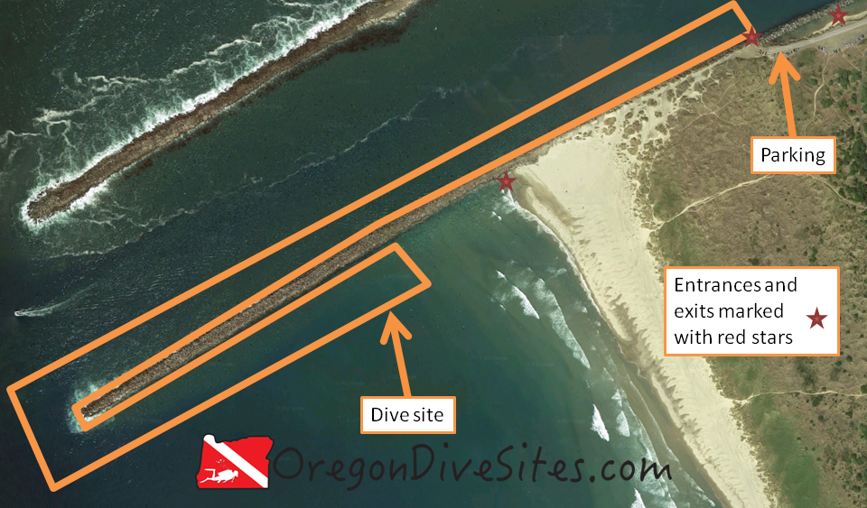
Take the aquarium exit from US101 and then follow Southwest Jetty Way toward the ocean.  Go to the very end of the road and find a parking spot.

Parking:

There is a lot of parking at the end of the road although sometimes it fills up with fishermen, surfers, and people enjoying the beach.  There is some parking a little further back toward Newport although you’ll have to walk a ways depending on which entrance you want to use.

jetty tip site map
Imagery ©2017 Google, Map data ©2017 Google. Diving the south jetty tip in Newport is a challenging experience that must be done in the right conditions.

Site Orientation:

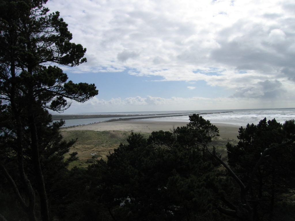
This site runs roughly west from the entrances.  The further out you get, the rougher the conditions you will encounter.  We have only one about halfway out to the end of the jetty tip ourselves because conditions have been too rough for us otherwise.

Boat traffic goes up and down the channel regularly.  It might be wise to fly a dive flag.  We have one that we love and use when we go SCUBA diving in Oregon.

Maybe 100 feet off the tip of the jetty there is a deep hole where water currents swirl around.  Unless you really know what you’re doing, we don’t suggest checking it out.

Entrances and Exits:

Most people climb over the jetty rocks into the channel at the parking lot.  Some people enter further up toward Newport by the fifth finger.  You can also do a surf entrance on the south side of the jetty along the beach.  The south side of the jetty is usually pretty shallow but if your goal is to reach the tip, the walk down to the water’s edge will save you a surface swim or bottom time.

Salt/Fresh:

This is a salt water dive

Shore/Boat:

This is usually done as a shore dive although a boat could drop you off at the jetty tip.  Boaters need to follow the rules with respect to the channel.  A good captain is highly recommended.

Normal Conditions:

Normally the jetty tip cannot be dived safely.  It is usually much too rough and with much too strong of a current to go out to the very end.  The inner part of the dive site that is more protected from the open ocean is more diveable when the ocean is acting up.  However, we strongly recommend you dive this site in advance of high tide so that you are pushed back into the bay rather than sucked out into the ocean.  You could also time your dive to start with the very tail end of the tide going out so that you will be pushed back in with the start of the high tide although visibility won’t be very good.

Surf, surge, breakers, boats, fishing lines, crab pots, and general rotten conditions are often found at the jetty tip.  Look at conditions at the end of the jetty before you make the choice to go out there.  Walk out to the end and look with your own eyes to see if you like what you see.  Be prepared to abort the dive and turn around if conditions deteriorate.  There is no glory in being a dead SCUBA diver.

Normal Visibility:

On the inner part of this dive site, we have experienced up to 30 feet of visibility depending on ocean conditions.  Usually you’ll find the visibility around 15-20 feet.  The bottom is all sand so there are no worries about stirring anything up.  If you start to get sucked out to sea, you may need to crawl along the bottom so the bottom being sand is a good thing.

Normal Temperature:

Water temperature is exactly the same as the ocean.  Expect between 45F and 55F depending on the time of year.

Best Time of Year:

There is no best time of year on this site.  You can only dive this site when the sea is calm.  Any other conditions will result in a very bad day for you.  Turn around if conditions deteriorate and live to dive another day.

Max Depth:

If you look off the very tip of the jetty, you can find about 60 feet of depth.  However, most of the site is around 20-30 feet.

Suggested Special Training:

This site requires advanced training and a very seasoned buddy pair of SCUBA divers.  At the minimum you need advanced open water training.  We recommend drift diver training.  We also recommend extensive experience with surf, surge, and strong, unpredictable currents.

Taking along a safety sausage or other distressed diver indicator is highly recommended.  We carry safety sausages with us no matter where we dive and we suggest you do, too.  Our favorite is listed on the Gear We Use page.

Difficulty of Dive:

This is an advanced dive.  You should not attempt this dive unless you really know what you are doing and conditions are right.

Distance of Walk to Entrance:

There is an entrance right by the parking lot where you climb over and down the jetty rocks.  The entrance is hard.

A 1000 foot walk down the jetty and onto the beach leads to a surf entrance.  Depending on which way the waves are coming in, this might be a calmer entrance.

Back toward Newport, some people prefer to enter near the fifth finger by climbing over the jetty rocks.

Surface Swim Length:

You can start diving immediately on the north side of the jetty.  On the south side, a 300 foot surface swim will get you to deeper water where you will experience slightly less surge.  If you want to reach the tip from the north side, we suggest a lengthy surface swim (1000+ feet) to get out a ways before you go down in order to conserve air.

Special Site Notes:

This is a no screwing around kind of dive site.  ONLY dive here if you really know what you’re doing, you are willing to assume the risks, and the conditions are right.  You can easily get sucked out to sea, bashed up on the rocks, or run over by a boat.  DO NOT TAKE THIS DIVE SITE LIGHTLY.

[Underwater Map of Dive Site Coming Soon!]

Closest Local Dive Shops to Get Air Fills and SCUBA Gear:

There is a local dive shop in the South Beach area of Newport that has an air fill station, gear rental and repair, and a limited selection of SCUBA gear for sale.

Nearby Restaurants We Like:

Both the north and south bayfronts have a wealth of good restaurants and brewpubs.

Nearby Places to Camp and Diver-Friendly Hotels:

The South Beach State Park campground is a good place to camp.  The yurts are a great idea in cold winter months.  We have not tried any of the hotels in town.  If you have and know of one that is diver friendly, please let us know!


What Other People Have to Say About This Site:

Please write in the comments below your experiences with this dive site!

Categories
Central Cascades

Trail Bridge Reservoir – Submerged River

The submerged riverbed of the McKenzie River in Trail Bridge Reservoir is a fun dive outside of Eugene, Oregon.  Depending on how much water is being discharged from the Smith Reservoir hydroelectric project through the powerhouse above this dive site, the site can be dived as a drift dive.  In lower water flow times, it is easy to swim underwater up one riverbank and down the other.  There are old stumps, logging cables, other logging detritus, and trout to be seen.  Visibility is usually 20+ feet but sometimes is better depending on the time of year and how much water is flowing through the reservoir.

A group of SCUBA divers getting ready for training dives as part of an Altitude Diver specialty course at Trail Bridge Reservoir.

Site Highlights:

The main highlight of this SCUBA diving site is the submerged riverbed of the McKenzie River.  On the east bank, Sweetwater Creek pours into the reservoir from a culvert in a small waterfall that is fun to swim under.  In the riverbed, we have found old choker cables from logging operations, many beer cans, and golf balls.  Sometimes you can spot the odd trout swimming by in the gentle current.  If you’re up for the challenging surface swim, you can swim far up the old riverbed toward the hydroelectric turbines at the very head end of Trail Bridge Reservoir where water from Smith Reservoir comes down the penstocks.  From there, you can do a leisurely drift dive back to your car.

Nearest Town:

This Oregon dive site is in the middle of nowhere.  Eugene and Springfield are the two closest big towns.  The little berg of Rainbow is down the McKenzie River Highway and has a few services.

GPS Coordinates:

44.279335 N, -122.045625 W

Special Directions to Site:

Most people coming to Trail Bridge Reservoir will come up the McKenzie River Highway (State Highway 126) from Eugene, Oregon.  The turn onto National Forest Road 730 can be tricky if there is a lot of traffic.  Slow down in advance and put your turn signal on early.

Parking:

We usually park right next to the old riverbed of the McKenzie River.  Sometimes people are camped here but the area is large enough that you can find a spot to park your car, assemble your dive gear, and get into the water.  In the winter, the snow is deep enough that there is nowhere to park and this reservoir is effectively closed to diving.

Check at the information kiosk to see if you need a day use or camping permit.  The last time we went diving at Trail Bridge Reservoir, it was free, but this might change in the future.

Trail Bridge Reservoir is a good place to camp for a few days while you dive the lakes up and down the McKenzie River.

Site Orientation:

The dive site runs roughly north-northeast to south-southwest.  At the top end, you will run out of water deep enough to dive in as you approach the hydroturbines.  Don’t get too close to the turbines!  You will hear the noise from the machinery as you start to get close to them.

At the southern portion of the dive site, the river opens up into the main body of Trail Bridge Reservoir.  We don’t usually go much further than the point of land that sticks out into the reservoir.  There is not too much to see further out and the swim back can be tiring if there is very much current.

Entrances and Exits:

There are several good entrances and exits right by the parking area.  We usually walk up to the upper-most entrance to get in and come out at the lowest exit on the spit of land that sticks out into the main body of Trail Bridge Reservoir.

Most of the entrances and exits have a large step or two on somewhat tricky ground to get down to the water.  Depending on how much water is in the reservoir, there can be more steps that you have to deal with.  The southern-most entrance/exit is very gentle and only about 100 feet away from the parking area.  If you have trouble with big steps, this is the best entrance for you.

We have seen some SCUBA divers get in further north along the old river channel but the entrances are very difficult with steep rocky descents down to the water.  If you want to do one of the entrances further up the old riverbed, scout it out ahead of time to determine if it’s something that you want to tackle.

Be courteous of other people who might be camped at or enjoying an afternoon at the lake.  Don’t walk through where they are having fun without asking permission.

Visibility is often 20 feet or better in Trail Bridge Reservoir. There are lots of little nooks and crannies along the submerged riverbed to explore.

Salt/Fresh:

This is a freshwater dive.

Shore/Boat:

This is a shore dive.  You could take a small inflatable zodiac up the channel to do the whole drift dive.  There is an area to launch boats further to the west in the lake.

Normal Conditions:

There is normally a gentle current in the lower stretch of this dive site.  In the upper end, the current can be a little more swift.  Depending on what the Eugene Water and Electric Board is doing with its many dams along the river, the lake level can rapidly rise or fall.  This can lead to big changes in the current.  At the top end of the dive site, the hydroelectric turbines make a lot of noise underwater.  Don’t get too close to the turbines.  Below the bottom of the dive site, there are dam works that you should steer clear of.  You don’t want to get sucked over, under, or through Trail Bridge Dam.

Normal Visibility:

Visibility is usually around 20 feet in the old river channel.  Because of the current, any stirred up silt will quickly be pushed away.

Normal Temperature:

We have seen water temperatures ranging from 40F to 52F depending on the time of year and how much water is flowing through the reservoir.  Early in the spring during the spring snow melt, water temperatures can be colder.  Occasionally, we have encountered a thermocline in the top few feet of the water column near the Sweetwater Creek waterfall on the east side of the dive site.  Very rarely, we’ve encountered some chilly water in the very bottom of the river bed.

Best Time of Year:

We prefer diving this site in the summer and fall.  The site can be dived in the spring after the snow has melted from the parking area although the water is colder then.  In the winter, the site is inaccessible because of the snow.

Max Depth:

If you take a shovel and start digging, you can hit 40 feet.  Most of the site is in the 25-30 foot range.  The farther upriver you go, the shallower it gets.

Suggested Special Training:

Open water divers with several dives under their belts will find this site accessible to them.  However, this is an altitude dive and you should have an altitude diver specialty course certification.  The reservoir is at 2,000 feet above sea level.  A drift diver specialty course is also useful if you are planning to do a drift dive.

Difficulty of Dive:

The diving is easy in the lower portion of the dive site.  In the upper portion, the dive can get more strenuous because of the current.  We rate this an intermediate skill level dive site because of the altitude.

Distance of Walk to Entrance:

Depending on which entrance you use, the walk is between 20 and 300 feet.  Some of the entrances have big steps on loose ground to get to the water while one of the entrances is a very mild walk into the water.

Surface Swim Length:

You can start diving right from the entrances or you can do a surface swim upriver to do a drift dive.  A surface swim of 1000 or more feet is possible here if you want to swim that far.

Special Site Notes:

The water level can change rapidly at this site due to what the Eugene Water and Electric Board is doing with the dams up and down the river.  We have observed people hitting golf balls into the reservoir aiming for SCUBA diver bubbles although usually it is friends of the divers doing the golfing.  This site is inaccessible in the winter.  Be mindful of not going too close to Trail Bridge Dam or of the hydroturbines upstream.

Remember that this is an altitude dive and you need to be trained on how to dive at altitude.

A good dive light will help you to see into the little nooks and crannies along the submerged riverbed.  We have several dive lights we recommend and use every time we dive in Oregon on our SCUBA Gear We Use page.

[Underwater Map of Dive Site Coming Soon!]

Closest Local Dive Shops to Get Air Fills and SCUBA Gear:

You’re a long way from any dive shops.  Eugene is the closest town with a shop for air fills or gear repairs.

Nearby Restaurants We Like:

Up at Clear Lake there is limited food service at the resort lodge.  Otherwise down toward the little town of Rainbow there are a few restaurants and convenience stores.

Nearby Places to Camp and Diver-Friendly Hotels:

There is plentiful camping at Trail Bridge Reservoir right at the dive site.  Up at Smith Reservoir and at Clear Lake there are additional camping grounds.  Clear Lake has resort cabins that can be rented.  The National Forest generally allows primitive camping but check with the local ranger station for current restrictions due to logging or fire danger.

What Other People Have to Say About This Site:

Please write in the comments below your experiences with this dive site!