Categories
Southern Oregon Coast

Coos Bay North Jetty

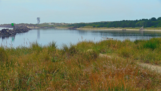
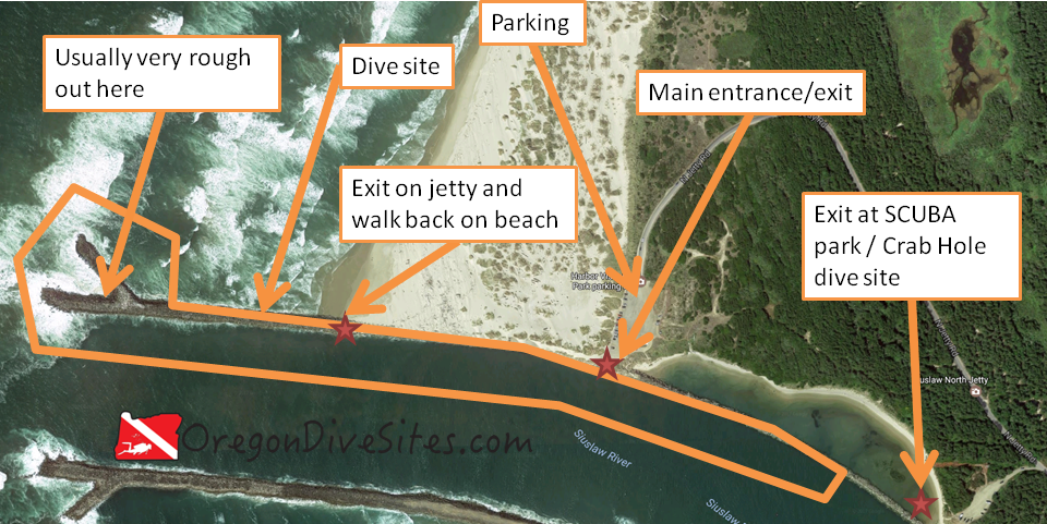
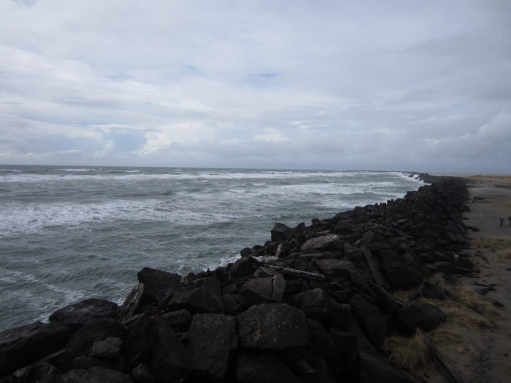
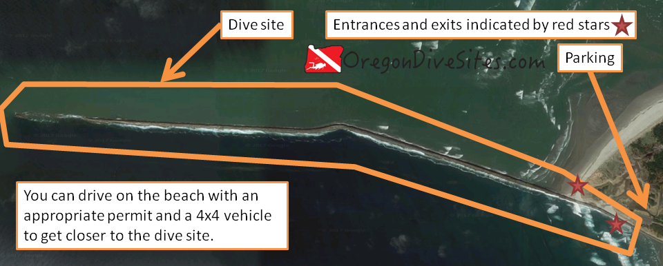
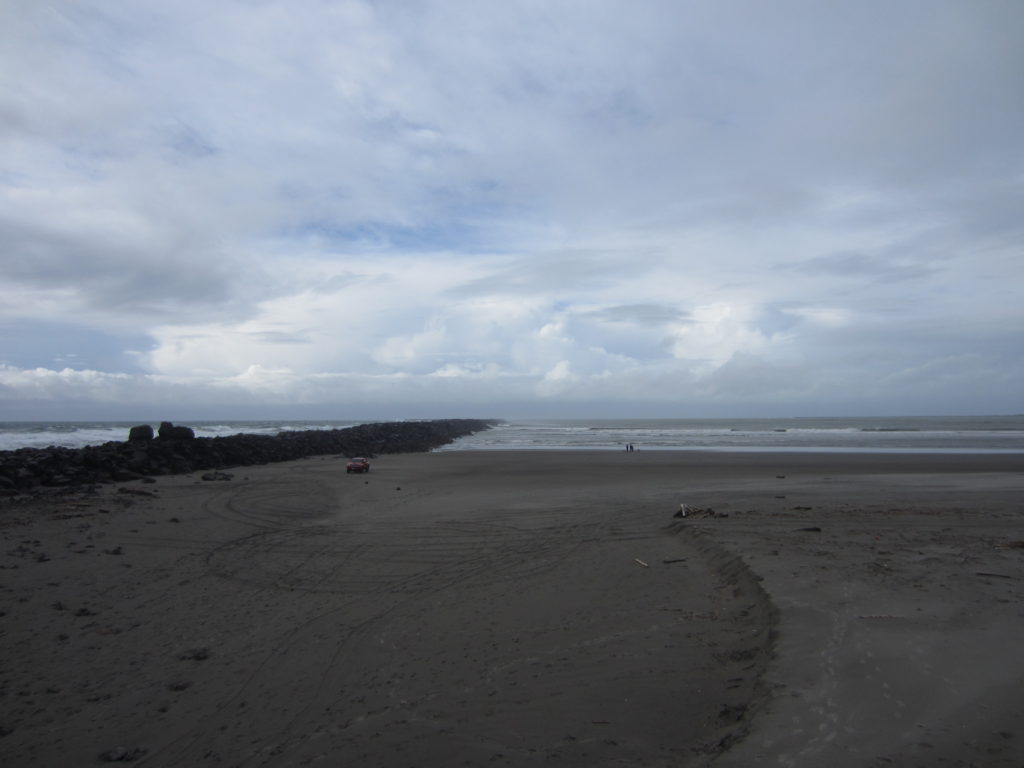
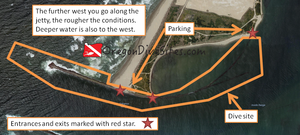
The Coos Bay north jetty is a bit difficult to access but is worth the drive.  There are places for freshly certified open water divers to dive and for battle hardened veteran divers to have a challenging day.  The inside eastern side of the dive site curls around along a partially-submerged jetty structure and provides generally tranquil waters for diving in almost any weather conditions.  The outer western part of the dive site is fully exposed to the wrath of the Pacific Ocean and is only diveable in favorable sea conditions.  Off the tip of the above-water part of the jetty, a long submerged part of the jetty keeps heading west.  Sometimes you can find interesting debris among those western rocks.  If you have the training, doing a drift dive here can be pretty fun.

coos bay north jetty
Imagery ©2017 Google, Map data ©2017 Google. The Coos Bay north jetty is a fun place to do a dive if you’re willing to drive across the sand to access the site. The further west you go, the more challenging the dive becomes. If you stay on the inner eastern part of the jetty, conditions are usually much better.


Site Highlights:

This site has a little of everything.  You can do an awesome drift dive here, riding the current in from the western part of the jetty to the northeastern part.  You can do some great spearfishing and crabbing anywhere along the jetty.  You can explore the sunken part of the western jetty looking for forgotten relics of wrecked ships.  You can practice your SCUBA skills in the protected waters on the north side of the inner part of the jetty.  You can hone your navigational skills in the triangle-shaped area of the inner jetty to see if you can successfully traverse between the two tips of the inner jetty.  There is a lot going for this dive site and it really warrants multiple dives to explore each part of the site.  The site is too big to fully cover except if you’re doing a drift dive.  And even then, it’s still pretty big.

Nearest Town:

If you were to swim due south from this dive site, you would run into Charleston, Oregon.  However, you’ll be coming from the north along the sand spit to get here.  In that case, the towns of Glasgow, North Bend, Empire, and Coos Bay are what you’ll come across first.

GPS Coordinates:

43.356317, -124.333814

Special Directions to Site:

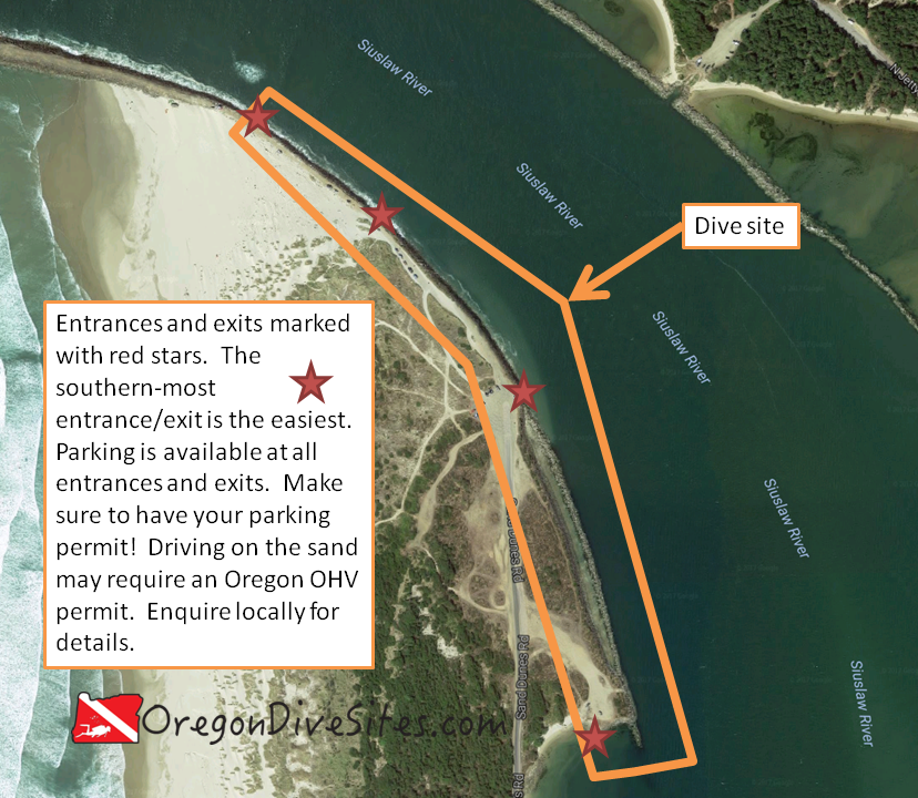
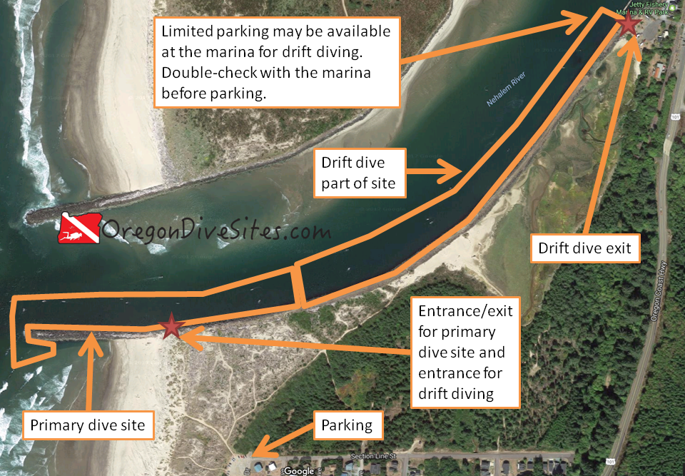
Access to this area is via some sand roads across the sand spit.  From US101 just north of the Coos Bay Bridge, turn onto Trans Pacific Lane.  Follow the road until you get to the Southport Lumber Mill.  Just before the mill, turn right onto the sand road (it is called South Dike Road but sometimes the sign is missing).  Keep going until you’re almost on the beach and then turn left (sometimes this is signed as Foredune Road).  Follow along this road south past the FAA tower and the former home of the wreck of the New Carissa.  As you get toward the bottom of the sand spit, there is a road that cuts back into the dunes.  This goes to the northeast side of the dive site.  The road that keeps heading south ends up on the western part of the dive site.

Since this is all sand, you need to be prepared to drive in the sand.  If you get stuck, the tow bill will be very large.
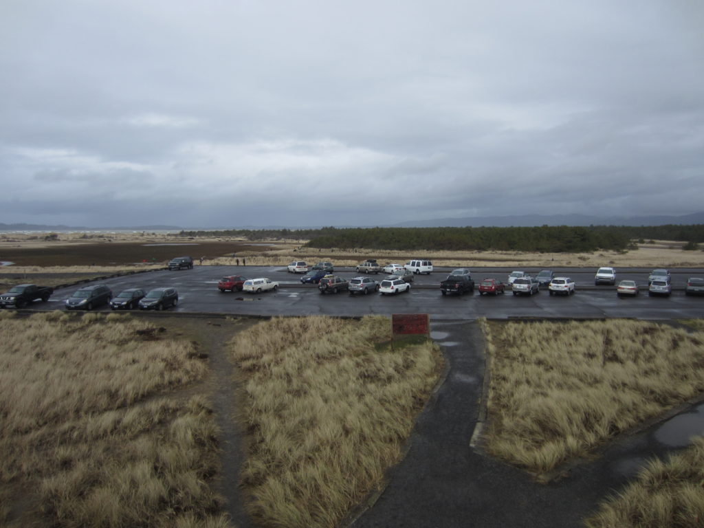
Parking:

This is a BLM site.  Check with the BLM to see what permits you need.  We think that you need to have an Oregon OHV permit for your street legal vehicle these days.  Note that the whole area is closed to vehicles from mid-March to mid-September.  Be sure to check locally before driving onto the sand.


Site Orientation:

The outer (western) part of the dive site along the Coos Bay north jetty heads mostly west.  The jetty dives under the waves as it heads further west.  The rubble on the bottom sometimes holds little secrets to be found.

As you move into Coos Bay, the jetty curls up to the north.  On the western side of the curved part of the jetty there is a fairly calm pool that is a good bet to go diving in rough sea conditions.  It’s shallower here but you might find some crabs along this part of the jetty.

On the south side of the jetty between the middle of the site and the north prat of the dive site, the site slowly gets shallower.  Around the area where the jetty splits into two, there are a few scattered underwater ruins to discover.

Entrances and Exits:

The entrances on the north east side of the Coos Bay north jetty are much easier to get in and out of the water.  Toward the west side of the dive site, you will be scrambling over jetty rocks.

Salt/Fresh:

This is a salt water dive.

Shore/Boat:

This is a shore dive.

Normal Conditions:

In the protected area to the west of the Coos Bay north jetty where it curls to the north, you will usually have fairly calm water.  Out in the river channel, you will almost certainly encounter current.  As you head further west along the jetty, conditions will get progressively rougher with surf, surge, waves, and current almost certainly waiting for you.

Normal Visibility:

Depending on ocean and river conditions, you may encounter 5 feet of viz or up to 25 feet of visibility.

Normal Temperature:

Except in the shallow protected area behind the Coos Bay north jetty where water can get up into the low 60s in the summer, the rest of the site ranges from 45 to 55F.

Best Time of Year:

Most of the dunes and sand roads are closed between mid March and mid September.  Unless you walk in on foot or take a boat in, it’s best to wait to dive this site when there aren’t seasonal closures due to nesting seabirds.

Max Depth:

Depth varies widely at this site.  At the far western tip of the Coos Bay north jetty, you’ll hit 50 feet.  Heading inland, the bottom rises up to be about 20 feet deep where the rocks come out of the water.  Near where the jetty and sand meet, you will find the bottom at around 40 feet.  Further up into Coos Bay, the water gets shallower.  On the northwest side of the Coos Bay north jetty in the protected area, water can be very shallow.

Suggested Special Training:

If you stay in the protected area, a freshly certified open water diver is capable of diving this site.  If you head out toward the tip jetty, you need to be an experienced diver.  For drift diving, you should have experience with it already and the proper training.  Conditions out on the jetty tip are almost always lousy so be prepared.

Difficulty of Dive:

We rate this as an intermediate dive although the western tip of the Coos Bay north jetty is usually an extremely advanced dive due to rough ocean conditions (if it’s diveable at all).  The protected area is a beginner dive.  The parts in between are more in the intermediate range.

Distance of Walk to Entrance:

Depending on where you drive and park, you might have a 50 foot walk or a multi mile walk.  Just be careful with driving in the sand.  Make sure you know how to drive in it and be ready to self-recover.

Surface Swim Length:

There isn’t any need for a surface swim here.

Special Site Notes:

Remember that road access is closed mid-March through mid-September.  When the weather is rough, we don’t recommend going out on the western tip of the jetty.

Closest Local Dive Shops to Get Air Fills and SCUBA Gear:

There used to be a dive shop in Coos Bay but it appears to have closed recently.  Down in Port Orford there is an air fill station at the harbor.  Up in Depoe Bay there might still be an air fill station available by appointment.  Otherwise you need to head inland toward Eugene or Grants Pass where there are full service SCUBA shops.

Nearby Restaurants We Like:

There is a lot of good food around Coos Bay.  You have to drive a ways from the dive site to get it but it’s worth it.

Nearby Places to Camp and Diver-Friendly Hotels:

We’ve never stayed overnight in Coos Bay so we can’t give any recommendations.  If you have some, please let us know!

What Other People Have to Say About This Site:

Please write in the comments below your experiences with this dive site!

Categories
Central Oregon Coast

Florence South Jetty Middle Area

Along the Siuslaw River in Florence the south jetty middle area is a good place to check out for some drift diving.  You can also do out-and-back dives but the current that often rips along the jetty wall is more appropriate for drift dives.  If you bring your mesh bag and a crab gauge, you probably can limit out on crabs here if you’re doing a longer drift dive.  This is a pretty good place to spend a lazy afternoon underwater on the Oregon coast.


Site Highlights:

This is a great drift dive.  Hopping in the water when you’re a little ahead of high tide is like riding a freight train.  You’ll zip right along the jetty heading up into Siuslaw Bay.  If you try to do this dive with the tide racing out to sea, you need to be very experienced and ready to exit over any part of the jetty so that you don’t end up outside the jetty out in the ocean.

There are a lot of crabs and fish along the jetty wall.  Bring your crab collection equipment and spear gun, and you’ll probably catch something good.

Nearest Town:

Florence, Oregon is just over the bridge on the north side of the Siuslaw River.

GPS Coordinates:

44.013354, -124.133215

Special Directions to Site:

Turn onto South Jetty Road from US101.  Bear right onto Sand Dunes Road by the Odd Fellows Hall.  Be sure to pick up a parking pass for the day by the entrance to the county park.  Drive all the way down Sand Dunes Road to the end.  You are now in the middle of the south jetty middle area dive site.

Parking:

This is a county park so be sure to get a day parking permit.  There usually is plenty of parking in several different areas.  Parking out along the jetty in the sand might be allowed with an OHV pass.  In the past we saw people do this.  However, inquire locally before you drive into the sand to make sure you won’t come back to a ticket on your car.


Imagery ©2017 Google, Map data ©2017 Google.
The south jetty middle area at Florence can be done as a drift dive. The southernmost entrance is the easiest with a sandy cove where you can walk into the water. The other entrances are classic Oregon jetty scrambles.

Site Orientation:

You want to stick close to the jetty at this dive site.  From the base to the half-way point, the dive site runs more or less to the north.  Then the jetty hooks toward the west.  If you want a navigational challenge and you have someone on the other side to meet you, you could navigate underwater across the channel and come up at the SCUBA Park.  We know someone who did this a few years ago.

The south end of the site has a protected area where you can make an easy entrance/exit.  We suggest exiting here.  Get in at the top of the dive site and ride the current into the bay before high tide.

Entrances and Exits:

The easiest entrance/exit is at the very southern end of the dive site.  The south jetty middle area is accessible anywhere along Sand Dunes Road.  The jetty entrances are a scramble (are there any that aren’t in Oregon?!).  The sandy beach entrance at the southern end of the site is nice enough that you might want to only explore around this area rather than try the drift dive and have to scramble over jetty rocks.

Salt/Fresh:

This is a salt water dive.

Shore/Boat:

This is a shore dive.

Normal Conditions:

The further out toward the ocean you go on this site, the more surf, surge, and general nastiness you might encounter.  There is almost always current on this site.  Right at high tide, everything slacks off for a few minutes and the water is calm.  The rest of the time, the water is really ripping and you’ll be taken where the tide is headed.

Normal Visibility:

Except during storms, viz here should be around 15-20 feet.

Normal Temperature:

Temperature can vary between 45 and 55F depending on the time of the year.

Best Time of Year:

We like diving this site in the spring and fall although it is accessible at any time.

Max Depth:

At the southern end of the site, you’ll probably find 30 feet of water where the channel swings close into the jetty.  At the northern end, you’re more likely to find around 20 feet although these numbers are dependent on when the shipping channel was last dredged and if there have been any big storms recently.  We’ve heard that sometimes you can find potholes along the jetty that get to be 45 feet deep although we can’t confirm that.

Suggested Special Training:

It’s a good idea to have advanced open water training and drift diver specialty training before attempting to do a drift dive here.

Difficulty of Dive:

We rate this as an intermediate dive as long as you’re heading into Siuslaw Bay rather than out to sea.

Distance of Walk to Entrance:

It all depends on where you park.  If you’re lucky, you’ll walk 50 feet.  If not, you will walk 1000+ feet.  If you have two cars, then you can shuttle gear and people.  Otherwise, you’ll have to walk back to your car after a drift dive (2000+ feet is possible).

Surface Swim Length:

No surface swim is necessary here.

Special Site Notes:

This is a drift dive so plan accordingly.  It’s a good idea to carry a good dive knife to cut yourself out of any monofilament you might encounter and a dive flag so that boats know where you are at.

Closest Local Dive Shops to Get Air Fills and SCUBA Gear:

There used to be a shop with an air fill station in Florence but it closed a long time ago.  Now you have to go down to Port Orford or up to Depoe Bay for an air fill station (both by appointment only) or inland to Eugene for a full service SCUBA shop.

Nearby Restaurants We Like:

The waterfront in old town Florence has a lot of good places to eat.

Nearby Places to Camp and Diver-Friendly Hotels:

There are a pile of county, state, and federal campgrounds in the area plus a few private ones.  We haven’t tried any of the local hotels so please get in touch with us if you know of a good one where divers are welcome.

What Other People Have to Say About This Site:

Please write in the comments below your experiences with this dive site!

Categories
Central Oregon Coast

Florence South Jetty Inner Fingers

The south jetty inner fingers at Florence are seldom visited by SCUBA divers but may be worth the effort if you are looking to do something a little different on the mouth of the Siuslaw River.  This salt water dive site is really four sites that are next to one another.  At the tips of the jetty fingers, currents dig holes in the sand where crabs often congregate.  This isn’t an amazing series of dives but they are interesting dives.  If you have a boat and want to check it out, put your boat in upriver and come down to the inner fingers.

Site Highlights:

The two highlights of this site are 1) the relative inaccessibility of the dive site compared to other sites around Florence and 2) crabs.  As far as jetty dives go, the dive sites along the north jetty in Florence have more micro life and often have more fish.  However, because so few people visit the inner fingers along the south jetty, crabs can sometimes be found here in abundance.  At the least, it’s worth a look if you’re bored with the other sites around Florence or if your attempt at going offshore to one of the reefs is canceled due to rough seas.

Nearest Town:

Florence, Oregon is just on the other side of the Siuslaw River.

GPS Coordinates:

44.001565, -124.127885

Special Directions to Site:

You’ll need a boat to access this site.  There are put-ins further up the Siuslaw River.  Pick your favorite boat launch and motor down river until you come alongside the US Coast Guard pier and boat house.  The four inner fingers are on the other bank of the Siuslaw.

Parking:

The boat launches all have decent parking for your truck and boat trailer.  Unless you fancy a long surface hike from one of the county beach access parking lots across sand and brush, there is no shore access.

south jetty fingers at florence
Imagery ©2017 Google, Map data ©2017 Google.
The inner fingers on the south jetty of the Siuslaw River have some interesting holes in the sand where crabs sometimes congregate.


Site Orientation:

The four fingers are spread out roughly north to south with the northern-most finger usually having the shallowest hole.  The other three fingers usually have deeper holes but it is very dependent on the season and how the river has been flowing.  If the US Army Corps of Engineers has recently done dredging in the Siuslaw River Channel, conditions will be unpredictable but the holes might get deeper and better for catching crabs.

The fingers themselves are generally pretty shallow heading to the west.  You can check out along the base of the fingers but there isn’t much reason to go beyond the holes at the finger tips.

Entrances and Exits:

This is pretty much strictly a boat dive.  Plan accordingly.

Salt/Fresh:

This is a salt water dive.

Shore/Boat:

This is a boat dive unless you love a very long hike across soft sand in SCUBA gear.

Normal Conditions:

There is usually current due to the tidal exchange and river conditions.  In the excavated out holes at the end of the fingers, water can swirl around and make a diver confused.  Good compass skills are a must so you don’t end up going the wrong way.  Generally there aren’t waves unless a ship is passing.  We have never seen surge or surf here but that doesn’t mean it can’t happen.

Normal Visibility:

Vis at the inner fingers on the south jetty usually is around 10-15 feet.  Sometimes it gets a little better and sometimes it’s much worse.  We suggest only diving these sites at high tide so you have the best chance of good viz.

Normal Temperature:

Being so far up into Siuslaw Bay, water temperature is largely driven by river conditions.  If a big slug of cold water from snow melt in the coast range is making its way down the river, you might see temps in the 40s.  Otherwise usually you’ll see the low to mid 50s at this site.

Best Time of Year:

This site can be dived at any time of year.  Do it during crabbing season if you want to catch crabs.

Max Depth:

It’s hard to say what depth you are going to find at the inner finger tips.  It’s not unheard of to find 25 feet of water in the holes.  However, you might only find 10 feet of water at high tide if sand from a recent storm has filled the holes in.  If you have a depth sounder on your boat, you can drive over the area to locate the deepest place to jump in at.

Suggested Special Training:

Advanced open water training is a good idea here.  You also should be skilled at boat diving and be prepared in case you get separated from your boat.

Difficulty of Dive:

This is an intermediate skill dive because of diving from a boat.

Distance of Walk to Entrance:

No walk is needed unless you’re braving the loooooong hike from a parking area.

Surface Swim Length:

No surface swim is needed unless you anchor your boat far away from the holes at the jetty tips or if you get separated from your boat.

Special Site Notes:

You’ll have more fun if you dive this site at high tide.  At low tide, there is very little water around the fingers.  It’s a good idea to run a dive flag here because of boat traffic.

Closest Local Dive Shops to Get Air Fills and SCUBA Gear:

Gone are the days of easy air fills on the central Oregon coast.  The shop in Florence is long gone.  The shop in Newport moved.  The air fill station in Depoe Bay is by appointment only.  Same goes for the one in Port Orford.  You’ll need to head over the coast mountains to Eugene for the closest local dive shop with air fills and full service.

Nearby Restaurants We Like:

The old town waterfront in Florence has lots of good restaurants.  Head there and pick one that looks tasty!

Nearby Places to Camp and Diver-Friendly Hotels:

There are a plethora of campgrounds that the county, state, and feds run around Florence.  We’ve stayed at a few and had pleasant experiences.  We haven’t tried any of the hotels so please let us know if you find a hotel that is SCUBA diver friendly!

What Other People Have to Say About This Site:

Please write in the comments below your experiences with this dive site!

Categories
Central Oregon Coast

The South Jetty Crab Dock at Florence

The south jetty crab dock at Florence is a good place to go diving if you’re bored of the north jetty dive sites along the Siuslaw, don’t want to go play in the mud at Woahink Lake, and aren’t feeling like doing the outer parts of the south jetty.  Crabs are usually pretty plentiful here although crabbers and fishermen up on the dock don’t usually enjoy divers underneath them when they’re trying to get some fish or crabs. You can link this dive site up with the other dive sites along the south jetty if you want to do some drift diving and this site is very protected from storms out in the ocean meaning that, as long as you’re okay with bad viz, this site is accessible most of the time.


.


Site Highlights:

This is a great site for SCUBA divers when the conditions are lousy on the north jetty or further out on the south jetty.  Being so far into the Siuslaw Bay, it makes for a well-protected dive site from the worst of the winter storms that often blow out the other dive sites along the Siuslaw.  The south jetty crab dock is also a good place to go crabbing and fishing although you should steer clear of fishermen and crabbers on the surface.  It’s not a bad idea to have a friend stay on the surface to help smooth over any tensions with top-side anglers and crabbers.

Nearest Town:

Florence, Oregon is just over the bridge.

GPS Coordinates:

44.007688, -124.131897

Special Directions to Site:

Heading south from Florence, after you cross the bridge over the Siuslaw River, turn right (west) onto South Jetty Road.  There should be signs for the south jetty county park and day use areas.  Bear to the right onto Sand Dunes Road and follow it until you see signs for the crab dock and south jetty beach 6 day use area.

Parking:

There is some parking right by the dock.  If this is full, just up the road there is a much larger parking area.  There is a day use fee here so be sure to pay it or get the appropriate yearly pass before parking.

Imagery ©2017 Google, Map data ©2017 Google.
The south jetty crab dock along the Siuslaw River is a great site to go dive when conditions are rough further out on the jetty or if you’re looking for a very easy jetty to dive.

Site Orientation:

The jetty runs roughly north-south with a very calm inner bay area to the west of the jetty and a mostly calm southern area south of the jetty.  To the east and north, the jetty is exposed to the Siuslaw River so current becomes much more of a factor.  If you hit this site at the wrong time, you can get sucked out along the jetty or pushed up into the bay.  However, if you’re smart about it, you can turn this into an awesome drift dive.

Be mindful of other users of the site.  Recreational crabbers and anglers can get pretty mad if they think you’re stealing their catch underwater.

Entrances and Exits:

There are a lot of really good entrances and exits at this site.  On the map above, we starred the absolute easiest entrances and exits.  However, you can hop into the water just about anywhere you want.  If you really want a jetty scramble, you can do that.  Otherwise, there are plenty of easy entrances on sandy beaches.  If you enter from the northern parking lot, you’ll be in very shallow water for a while but otherwise all of these entrances and exits are in deeper water.

Salt/Fresh:

This is a salt water dive

Shore/Boat:

This is a shore dive.

Normal Conditions:

Except at high and low tide, the current can really rip along the eastern side of the jetty where the deepest part of the Siuslaw River channel is located.  If you’re doing a drift dive, this is great.  If not, it’s a good idea to stay on the west side of the jetty so you’re not getting pushed around by the water.

There never is much surf or surge here.  We haven’t seen any big waves except when a boat passes by.  In general, this is a pretty benign dive site, and especially when considering that this is on an Oregon coast jetty!

Normal Visibility:

In good conditions at high tide, you can hit 20 feet of viz on the south jetty crab dock.  However, if there is a bunch of silt coming down the Siuslaw River or if there’s a big storm out in the ocean, viz can go down to 5 feet at times.  Usually it’s around 15 feet here.

Normal Temperature:

The south jetty crab dock is impacted by both the water pumping out of the Siuslaw River and by the water out in the Pacific Ocean.  If there is a big spring runoff event with a bunch of snow melt, then you might see 40 degrees.  It can get up to about 60 F on the western little bay area in the summer when the weather is warm and the sun has been out for a few days.  Normally you’ll probably find around 50-55F water temps here.

Best Time of Year:

Any time of year is a good time to check out the south jetty crab dock.

Max Depth:

On the east side of the jetty and near the northern tip of the jetty you’ll sometimes find 25-30 feet of water.  On the west side of the jetty, you’ll be in around 15 feet of water at high tide.

Suggested Special Training:

Recently certified open water divers can successfully dive this site.  If you’re going to do a drift dive, you should have drift diver specialty training.

Difficulty of Dive:

We rate this as an easy dive unless you’re doing drift diving or if you hit the site when the tide is ripping.

Distance of Walk to Entrance:

Depending on where you park and where you enter, you might have between a 5 foot and a 500 foot walk to your entrance.

Surface Swim Length:

If you enter up by the north parking lot, you’ll end up with a 200 foot surface swim to get to deeper water.  Otherwise, the other entrances don’t really need any surface swims to get to the good diving.

Special Site Notes:

Dive this site at high tide for the deepest water you can get at this site.  Especially on the west and south sides, it gets rather shallow.  Be careful of the current in the river channel.  It can go from zero to ripping in just a few seconds.

Be courteous to other users of this site.  There are a lot of people who go crabbing and fishing here.  It’s not a bad idea to have a friend stay on the surface and smooth over any tensions with above-water site users.

It’s a good idea to carry a good dive knife or line cutter.  There can be quite a bit of lost monofilament at this site.  Getting tangled in fishing line sucks but if you have a good knife, you can get yourself free.

Closest Local Dive Shops to Get Air Fills and SCUBA Gear:

You have a long way to go for a dive shop or air fill.  There is a by-appointment-only air fill station up in Depoe Bay and another down in Port Orford.  Otherwise, head over the coast range mountains to Eugene where there’s a full service dive shop.

Nearby Restaurants We Like:

There is a lot of good food in old town Florence along the waterfront.

Nearby Places to Camp and Diver-Friendly Hotels:

There are a lot of county, state, and federal campgrounds in the area that are great for tent camping or for an RV.  We’ve based out of a few of the campgrounds around here to go diving and haven’t been disappointed.

We haven’t tried out any of the hotels in the area so please let us know if there’s a SCUBA diver friendly hotel nearby that you like.

What Other People Have to Say About This Site:

Please write in the comments below your experiences with this dive site!

Categories
Central Oregon

Fogarty Creek Kelp Forest

In just the right conditions, the kelp forest at Fogarty Creek is accessible to SCUBA divers from shore.  There are not very many places in Oregon where divers can access kelp forests without a boat.  The surf entrance can be tricky and conditions can change fast but if it you hit the beach at the right time, you can go dive some great kelp beds.  We have not been able to dive this site yet due to unfavorable conditions when we have tried in the past but we have heard of others diving here and from everything we have observed, it looks like a good spot to check out when the seas are kind and calm.


Site Highlights:

The main draw here is the kelp beds just off shore from Fogarty Creek.  There are some interesting rock formations to check out, too.  Someday otters will once again live here but for now, it will only be us SCUBA divers and a few other mammals visiting these kelp beds.

Nearest Town:

Lincoln Beach is just north of Fogarty Creek and just to the south is Depoe Bay.

GPS Coordinates:

44.839318, -124.051719


Special Directions to Site:

Watch for the Fogarty Creek State Recreation Area signs on US101 north of Depoe Bay.

Parking:

There is plenty of parking at the state rec area.  You will probably have to pay to park here but double-check the signs.

fogarty creek kelp forest
Imagery ©2017 Google, Map data ©2017 Google.
The kelp forest at Fogarty Creek is shore-accessible in calm sea conditions.


Site Orientation:

The kelp forest is split into two parts.  The northern kelp forest is larger but a bit more of a surface swim to get to.  The southern kelp forest is smaller and a shorter swim.  There are some interesting rock formations near the southern kelp forest that can also be visited.

One thing to remember here is that surf conditions need to be really good before you try diving at Fogarty Creek.  There aren’t many beach surf entrances in Oregon and it is important to know how to do safe entrances and exits from the beach.  We’re not your mom so make sure you know what you’re doing.

Entrances and Exits:

You can enter or exit just about anywhere along the beach but doing your entrance/exit nearer to the area you want to dive is a good idea.  However, you need to do an entrance and an exit where it is safe to do so.  Surf conditions, current, undertow, and other conditions will dictate where it is best to enter/exit.  If you don’t know how to do an army crawl out of the water, you should get instruction on how to do so.

Salt/Fresh:

This is a salt water dive.

Shore/Boat:

This is a shore dive although you can also access the site from a boat.  If you wanted to, you could probably put in an inflatable raft with an engine here.  We have not done this yet so be sure to double-check with the relevant state authorities before launching a boat from Fogarty Creek Beach.

Normal Conditions:

Normally the conditions are rotten here.  Surf, surge, current, waves, undertow, and many other bad and nasty things are the norm here.  On a rare calm day, you will have better conditions but there are still dangers here.

Normal Visibility:

Viz can be up to 30 feet here.  Sometimes it’s even better.  The summer upwelling can reduce visibility and right after a storm there will be worse viz.

Normal Temperature:

Depending on the time of year, you will see temperatures between 45 and 55F.

Best Time of Year:

There isn’t really a good time of year to dive here but in the summer and early fall, you have a better shot of having halfway decent conditions to dive Fogarty Creek Kelp Forest.

Max Depth:

This is a fairly shallow site which makes surge much worse here than other deeper kelp beds in Oregon.  You can find 30 feet on the far west side of the kelp beds.

Suggested Special Training:

Advanced open water training is a really good idea before diving this site.  Rescue diver training is a good idea.  Lots of practice and training in surf entrances and exits is needed here.

Difficulty of Dive:

This is an advanced dive.  You need to know what you’re doing before you do a shore dive into the open ocean.  Even people with many dives on the Oregon coast can make mistakes here that can lead to being killed or even worse.  Be sure you know what you’re doing and you’re comfortable with the conditions before you go diving.

Distance of Walk to Entrance:

You will have between 500 and 1000 feet to walk to get to the entrance.

Surface Swim Length:

A surface swim between 100 and 200 feet is a good idea to get into some deeper water.

Special Site Notes:

This site is dangerous in all but the best conditions.  In even ideal conditions, the site is still dangerous.  Take a safety sausage.  Have a friend keep track of you from the surface.  Be sure you have plenty of air in your tank in case you have to belly crawl out of the surf.

Closest Local Dive Shops to Get Air Fills and SCUBA Gear:

There is an air fill station in Depoe Bay that you can get air at by appointment only.  Otherwise you’ll need to go up to Astoria or in to Portland, Salem, or Eugene for a full service SCUBA shop.

Nearby Restaurants We Like:

There is lots of good food on this part of the coast.  Let us know what your favorite place is!

Nearby Places to Camp and Diver-Friendly Hotels:

There are several state campgrounds in the area as well as many hotels and vacation rentals.  We haven’t tried any of the lodging outside of tent camping around here so please let us know if you have found a good hotel or house that welcomes divers.

What Other People Have to Say About This Site:

Please write in the comments below your experiences with this dive site!

Categories
Northern Oregon Coast

The South Jetty at Nehalem

The south jetty at the mouth of the Nehalem river is a fun place to dive that is a little off the beaten track for many divers.  The walk to the entrance dissuades many people from attempting this dive but it is well worth the hike if you want to try out a new site.  Crabbing and spearfishing are both usually pretty good along the outer part of the jetty.  On the inner part of the jetty, it is possible to drift dive way up into the Nehalem river system.

The south jetty as seen from Nedonna Beach.


Site Highlights:

The things people come here for are spearfishing and crabbing, and drift diving.  During crabbing season, the deep water along the south jetty is packed with boats that people rent from the marinas up the Nehalem River.  Sport fishing is a little less common than crabbing but is just as good for those in boats or sitting on the jetty.  Underwater there are ample opportunities to catch your limit of just about everything that the law allows you to take while diving.

For the more adventurous, you can drift dive from the entrance on the jetty all the way back up into the Nehalem River.  The first marina up the river is where you want to shoot to exit unless you want to spend several hours lazily drifting along upstream with the incoming tide.

Nearest Town:

The little town of Nedonna Beach is the closest to the dive site.  Further north is the town of Nehalem and several other small settlements.  To the south, the bigger towns of Garibaldi and Tillamook await.  Smaller villages and towns are also just south of the dive site.

GPS Coordinates:

45.655438, -123.939354

Special Directions to Site:

From US101 turn onto Beach Street (follow signs for Nedonna Beach).  Beach Street will turn to the right (north).  Follow it all the way to the end of the road were Section Line Street intersects.  There is a public parking area here.

The first marina upriver from the south jetty on the Nehalem River is just off US101 and is well-signed.

Parking:

The last time we were here, the parking was free and public at Nedonna Beach.  On busy beach days, you might have trouble finding a place to park.  Be sure to check the signs when you get to the parking area to make sure it’s still free.

The parking at the marina upriver from the jetty may be free but you need to talk with the marina before you park.  You also need to talk with the marina to make sure they’re okay with you using it as an exit point.

nehalem jetty south
Imagery ©2017 Google, Map data ©2017 Google.
The south jetty at Nehalem is a good place to dive a little off the beaten path and there are some great drift diving opportunities if you are here off-tide.

Site Orientation:

The primary dive site runs east-west along the jetty structure.  Toward the jetty tip, conditions get rougher.  If the weather is bad, stay on the inner part of the primary dive site.  If conditions are good, you can dive around the tip of the jetty and a little inward toward the beach.  You could even do a surf exit if you really wanted to.  However, water gets shallow fast on the south side of the jetty.

The drift dive part of the site follows the Nehalem River up into the Nehalem Bay.  We start our dives a few hours before high tide so there is sufficient water still to come into the bay to propel us upstream.  You will still have to do some swimming.  It’s the best to do this when there is a large exchange between low and high tides to increase the speed at which you go upriver and decrease the need for swimming.

Entrances and Exits:

The primary site entrance/exit and the drift dive entrance are along the jetty.  Be sure to scout out where you want to enter based on local conditions.  Where the beach grass and jetty intersect is a good place to start looking.

If you’re drift diving, the exit is up at the first marina as you go up the Nehalem River.  Be sure to plan your dive well before you try a drift dive here because it is easy to either under or over shoot your exit.  You don’t want to be floating along the surface for an hour waiting to exit or end up in the town of Nehalem and have to hitch hike back.

Salt/Fresh:

This is a salt water dive.

Shore/Boat:

This is usually done as a shore dive although if you have a boat to put in at one of the many private marinas or public boat ramps, you can do this site from a boat.  If you are doing a drift dive, a support boat can be pretty useful in case you want to exit the water earlier than the first marina.

Normal Conditions:

Out on the jetty tip, conditions are often rough.  Surf, surge, current, waves, and other nastiness can be expected most of the time.  As you go further in the Nehalem River, conditions steadily improve until all you are really concerned about is boat wakes and fishing line.

Normal Visibility:

Visibility can vary wildly at this site.  If you do this site on a calm day in good conditions, you can get 20 feet of viz on the jetty.  If a bunch of silt and sediment has been pumping down the river lately, you can end up with very low visibility.

Normal Temperature:

Out on the end of the jetty, expect Pacific Ocean temperatures (45-55F depending on the time of year).  Inland, the river starts to influence conditions more.  In the summer you might see 60F and in the winter maybe 40F depending on upriver snow melt.

Best Time of Year:

This site is accessible any time of the year due to how large it is.  Plan what part of the site you dive based on local conditions.

Max Depth:

Along the outer jetty, you will find 30 feet of water.  As you go upriver on the Nehalem, expect 20-25 feet of water depending on how high of a tide you’re riding.

Suggested Special Training:

If you are staying in the primary dive site, open water divers with experience diving Oregon jetties can do the dive.  As you go toward the jetty tip in rougher conditions, you will want advanced training and experience in those conditions.  If you are doing a drift dive, you should have a drift diver specialty and experience with drift diving on a river system.

Difficulty of Dive:

We rate this as an intermediate dive although the drift dive can get a little more tricky and the jetty tip can be very challenging.  If you stay in the primary dive site though, we think this is an intermediate-level dive.

Distance of Walk to Entrance:

You’re in for a 1000+ foot walk to the jetty from the parking area in Nedonna Beach.  A cart capable of travel over the sand and some friends who will watch your stuff while you’re diving are both a good idea.

If you do the drift dive, you will either need two cars, a friend to shuttle your car, or be willing to hitch hike to get back to your car.  There may be limited taxi service in the area but we suspect they won’t take kindly to wet SCUBA gear in their van.

Surface Swim Length:

No surface swim is needed on the primary dive site.  The drift dive could end up with a very lengthy surface swim if conditions are not good for doing a drift dive.  There aren’t really any exits between Nedonna Beach and the marina.  The distance between the drift dive entrance and drift dive exit is about 3500 feet.  Be sure to plan accordingly.

Special Site Notes:

If you’re diving the primary site, do it at high tide.  If you’re doing the drift dive, do it only when conditions are right (big tidal exchange) and start your dive an hour or two before high tide so that you’re riding the tide up the river.  We don’t recommend trying to do the drift dive in reverse because you could easily overshoot your exit on the jetty and end up getting sucked out to sea which would be unpleasant indeed.

Be sure to talk to the people at the marina before doing a drift dive both about the parking situation and to double-check that they will allow SCUBA divers to exit there.  You might be able to talk them into transporting you and your gear back to Nedonna Beach in one of their pickups if it’s a slow day.

It’s a VERY good idea to fly a dive flag both at the primary and the drift dive portions of this site.  There is a surprising amount of small boat traffic along the Nehalem River and jetty.  A good dive knife is also a good idea in case you encounter fishing line and get tangled.

Closest Local Dive Shops to Get Air Fills and SCUBA Gear:

There used to be a place you could get air fills at the Port of Garibaldi although we can’t confirm if it is still in operation.  Otherwise, Astoria has a full service SCUBA shop.  In Depoe Bay there is an air fill station that is by appointment only.  After that, you’re looking at going inland to Portland or Salem for an air fill or gear service.  It’s a good idea to be self-sufficient if you’re diving out on this section of the Oregon coast.

Nearby Restaurants We Like:

There is a lot of good food up and down the coast in this area.  You are spoiled for choices here.

Nearby Places to Camp and Diver-Friendly Hotels:

There are a lot of local campgrounds, vacation house rentals, and hotels in the area.  We haven’t tried any of the hotels or vacation house rentals so please let us know if you have a favorite that is SCUBA-friendly.

What Other People Have to Say About This Site:

Please write in the comments below your experiences with this dive site!

Categories
Central Oregon

Lower Deschutes Boat Ramp at Lake Billy Chinook

The lower Deschutes boat ramp on Lake Billy Chinook is a good place to go diving in Central Oregon.  You can go very deep here if you want or you can stay more shallow to check out the underwater cliff faces, the underwater rock formations, and search for things lost by boaters.

Cove Palisades SP Oregon 2002.03.31
The lower Deschutes boat ramp at Cove Palisades State Park is on the west side of the “Island” in the middle of this picture. Ipoellet at the English language Wikipedia [GFDL or CC-BY-SA-3.0], via Wikimedia Commons

Site Highlights:

The lower Deschutes boat ramp is an exciting place to dive because of the underwater cliffs and rock formations.  Much like some of the other sites on Lake Billy Chinook, this site has a variety of terrain from relatively shallow sandy areas near the roped-off swimming spots to sheer vertical underwater cliffs.  You can often find things that fell off boats around the boat ramp and other random odds and ends that went overboard in the general dive site area.

Nearest Town:

There are a few small towns nearby including Culver, Metolius, and Madras.  To the south, Bend and Redmond have some dive shops.

GPS Coordinates:

44.547443, -121.279279

Special Directions to Site:

There are signs on US 97 for Cove Palisades State Park.  Follow them through a series of roads until you descend down into the canyon.  Look for signs for the lower Deschutes boat ramp once you’ve crossed the bridge over the Crooked River finger of the lake.

Parking:

There is usually ample parking although on busy summer weekends, it can be completely full.  The last time we were here, we had to pay a day use fee to park.  Your Oregon State Parks Pass might work here but double-check when you go to park to see what you need to do.  You can drop your gear off down by the boat ramp after you have your equipment setup and then go park in the car parking area.  If it’s a quiet day with not many boat trailers, you can usually get away with leaving your car in the boat trailer parking.


Imagery ©2017 Google, Map data ©2017 Google.
The lower Deschutes boat ramp is a good place to dive in Lake Billy Chinook. The underwater terrain is varied and you can go very deep if you want or you can stay shallower in a few areas.

Site Orientation:

This site runs more or less north-south.  There is a little bay in the middle of the site that heads east and is where the boat ramp is located.  The little bay and the area around the roped off swimming spot are the shallowest and gentlest places to dive.  If you go further west, north, or south, things get deep very quickly and also very steep.  There are some vertical underwater cliffs as well.  If you head west and don’t watch your gauges, you can go beyond recreational scuba depth limits so pay attention!

Entrances and Exits:

If there isn’t much boat traffic, you can hop in at the boat ramp.  Otherwise, the swimming beach is an easy entrance with a nice and sandy spot to walk in.  To the west and south, there are a couple swim ladders you can climb in on from the wall where boats sometimes tie up.

Salt/Fresh:

This is a fresh water dive.

Shore/Boat:

We have done this as a shore dive but you can also do boat diving here.  If you’re spending a long weekend on Lake Billy Chinook with your pontoon boat, this is a good dive site to check out your gear and practice your boat entrances and exits before motoring out into other parts of the lake.

Normal Conditions:

Usually there isn’t much current unless you get deep enough and usually there aren’t many naturally occurring waves.  There can be waves and wake from boats passing by though.  This lake is very popular with many different types of boaters so it’s important to fly a dive flag, even if you’re diving from a boat.

Normal Visibility:

Except in the swimming area and right around the boat ramp, visibility is usually pretty good with viz often being 40-60 feet or better.  Where the water gets stirred up, it can be quite a bit lower.  The bottom doesn’t have much to stir up.

Normal Temperature:

The deeper you go, the colder it usually gets at the lower Deschutes boat ramp.  On the surface in late summer, we’ve seen in the 70s at this SCUBA site while at depth it can still be in the low 40s.

Best Time of Year:

This site is diveable any time of the year although we prefer summer and fall.

Max Depth:

We’ve gone down as far as 80 feet here but you can exceed the maximum recreational SCUBA depth limits if you aren’t careful.

Suggested Special Training:

This is an altitude diving site.  We suggest having at least advanced open water training because of the potential to go very deep very quickly.

Difficulty of Dive:

We rate this as an intermediate dive because of the depth.

Distance of Walk to Entrance:

Depending on how close you can get your car, you may have to walk only a few feet or a couple thousand feet.

Surface Swim Length:

No surface swim is necessary at the lower Deschutes boat ramp.

Special Site Notes:

This site has a lot of boat traffic during high season (summer and fall).  Fly a dive flag!

Closest Local Dive Shops to Get Air Fills and SCUBA Gear:

There are a few SCUBA shops in Bend that offer full service.

Nearby Restaurants We Like:

We haven’t tried any of the restaurants right by the lake so please let us know if you have a favorite.

Nearby Places to Camp and Diver-Friendly Hotels:

There are several state and federal-run campsites in the area as well as a private resort with cabins for rent.

What Other People Have to Say About This Site:

Please write in the comments below your experiences with this dive site!

Categories
Central Cascades

Ice Cap Creek at Carmen Reservoir

The Ice Cap Creek Day Use Area at Carmen Reservoir is a fun place to play around in a submerged creek bed to practice your drift diving skills.  Since this is an altitude dive, it’s a good place to practice using the altitude dive tables.  The water is usually quite cold but not as cold (usually) as Clear Lake can be at the bottom of Clear Lake’s underwater springs.

old metal pot
We found an old metal pot the last time we were at this dive site.


Site Highlights:

There are a couple reasons that SCUBA folks like diving the Ice Cap Creek Day Use Area.  The site has very easy access to get into and out of the water.  You can practice drift diving in the submerged riverbed.  The site is mostly easy to dive making it accessible to even freshly certified open water divers, assuming you have proper altitude diver training.  In short: this is a good site to play around at and practice your skills.  You might also discover some old pots and pans, logging equipment, and other odds and ends tossed into the reservoir.

Nearest Town:

This dive site is pretty remote.  There are very limited services at the resort at Clear Lake.  Otherwise slightly bigger towns within an hour drive are Detroit, Rainbow, and Sisters.  Bigger towns with services are Eugene, Salem, and Bend although they are all more than an hour away.

GPS Coordinates:

44.340039, -122.002339

Special Directions to Site:

The forest road NF-750 gives access to the Ice Cap Creek Day Use Area.  The road is a mile and a half or so south (down river) from the bottom of Clear Lake.  Watch carefully for the signs because it is easy to miss the turn.

Parking:

The last time we were here, there was ample free parking and several locations.  Double check when you arrive to make sure that the parking is still free.  It’s possible the National Forest might turn this into a fee pay site.


carmen reservoir ice cap creek
Imagery ©2017 Google, Map data ©2017 Google.
The Ice Cap Creek Day Use Area at Carmen Reservoir is a good place to do some high altitude diving in Oregon. The river coming into the reservoir can be fun to explore.

Site Orientation:

The site is roughly oriented to the cardinal directions (north-south-east-west).  The Ice Cap Creek Day Use Area is at the north end of the site and with the McKenzie River’s sunken channel coming in at the top end of the dive site.  The river channel runs from the northeast to the southwest where it terminates at the dam’s spillway.  Don’t get too close to the spillway structure!  You don’t want to end up downriver of the dam or getting sucked into the water intake.  You can swim up the river channel under the bridge quite a ways.  This makes for a good spot to practice drift diving.

On the east side of the site, we usually use the finger-like jetty structure on the dam to the south and the parking area to the north as our site boundary.  Further to the east is the other dive site at Carmen Reservoir.

On the northwest side of the dive site, the water gets very shallow.  We don’t think there’s much reason to explore that area.

Entrances and Exits:

The two easiest entrances/exits are at the parking areas.  There is a bit of a scramble step or two to get down to the water but it isn’t too bad.

Salt/Fresh:

This is a fresh water dive.

Shore/Boat:

This is a shore dive.

Normal Conditions:

Normally the water is cold and clear.  There is always a current around the sunken river channel.  Boats can occasionally be in the lake so it’s a good idea to fly a dive flag.  Note that this is an altitude dive.

Normal Visibility:

Usually visibility is quite good since the majority of the water is coming almost directly out of Clear Lake.  Expect 20-40 feet of viz depending on how much surface runoff is coming into the lake.  Close to the Ice Cap Creek Day Use Area you can run into silt on the bottom that can be stirred up but as long as you’re near the sunken river channel, any silt that is stirred up clears quickly.

Normal Temperature:

We’ve seen water temperatures in the river channel as cold as 38F and temps away from the channel near the surface as high as 60F depending on the time of the year.

Best Time of Year:

This site is best in the summer and fall.  Once the snow melts enough for the road to open in the spring, the water is usually very cold.  In the winter, you can’t get to the lake because of the snow.

Max Depth:

We once found 60 feet near the dam in the old river channel but most of the site is more in the 20-40 foot range.

Suggested Special Training:

This is an altitude site where you should have altitude diver training.  Open water divers can successfully dive this site as long as you stay away from the dam intake structure.  This is a great place to practice your dive skills and do training.

Difficulty of Dive:

We think this is a pretty easy dive for the most part so we rate it as a beginner skill level site.

Distance of Walk to Entrance:

Unless there are a lot of people parked at the parking areas, you shouldn’t have to walk more than 50 feet.

Surface Swim Length:

No surface swim is needed.

Special Site Notes:

Because of how cold the water here can be, you should make sure your equipment is rated for cold water.  We have had a regulator free flow up at Clear Lake just up the river.  Be sure to remember your training in case you have that situation happen to you.

The dam intake structure can suck you in, chew you up, kill you very dead, and leave a hefty bill for your next of kin to recover your sliced and diced body.  Steer clear of it!

Closest Local Dive Shops to Get Air Fills and SCUBA Gear:

The closest dive shops are located in Bend, Salem, and Eugene.  Each is quite a ways away (1.5+ hours) so you need to be self-sufficient at the Ice Cap Creek Day Use Area.

Nearby Restaurants We Like:

The closest food is up at Clear Lake’s resort where very limited food service is available.  Otherwise, in Detroit, Camp Sherman, and Rainbow (all towns within an hour of the site) you can find a few restaurants.

Nearby Places to Camp and Diver-Friendly Hotels:

If you want to sleep in a cabin, the resort at Clear Lake does rent cabins to divers.  Be sure to ask when you make your reservation about how you can store your gear.  Otherwise, there are plenty of National Forest campgrounds and lots of primitive camping in the forest.

What Other People Have to Say About This Site:

Please write in the comments below your experiences with this dive site!

Categories
Central Oregon Coast

Florence – North Jetty End of the Road Parking Lot

The north jetty on the Siuslaw River at Florence is a great place to do some diving on the Oregon Coast.  At the west parking lot near the observation tower, a short jetty scramble leads to good spearfishing and crabbing.  If you plan your dive with the tide, you can drift dive this site riding the tide out from the SCUBA Park to the east or head that direction if you ride the tide in.

North Jetty in Florence, Oregon
The western parking lot along the north jetty at Florence is a more difficult entrance and exit than the SCUBA park to the east but is a quieter dive site and often has good spearfishing. “North Jetty in Florence, Oregon” by Rick Obst is licensed under CC BY 2.0


Site Highlights:

The main reason we dive this site is to go spearfishing and crabbing.  While Crab Hole further east on the north jetty gets fished all the time, the further west part of the north jetty gets less hunting.  We have done some drift dives here as well where we follow the tide back toward Florence.

Nearest Town:

Florence, Oregon is just up the north jetty.

GPS Coordinates:

44.018318, -124.137102

Special Directions to Site:

From US101, head west on 35th Street.  Take a right on Rhododendron Drive then take a left on North Jetty Drive.  Follow North Jetty Drive all the way to the end.

Parking:

There is usually plenty of free parking right by the jetty.  Check the signs to make sure the situation hasn’t changed, but we’ve never paid for parking here.

Imagery ©2017 Google, Map data ©2017 Google.
There are a lot of options to dive this site. You can hop in at the SCUBA Park entrance and ride the tide as a drift dive to an exit at the west parking lot on the Florence north jetty. Or you can stick close to the west parking lot. Or you can head for the ocean and hop out along the jetty and walk back across the sand.

Site Orientation:

The site runs east-west.  Stick close to the jetty rocks.  We haven’t found much of interest out in the channel other than a bunch of sand.

As you get further west, conditions deteriorate.  The dive becomes more advanced the closer to the tip of the jetty you get.

If you run this as a drift dive, you can drift all the way back to Crab Hole.  Watch for the big underwater pipe that marks the exit through the fish ladder.

Entrances and Exits:

The main entrance/exit here is over the jetty at the parking lot.  If you end up out toward the end of the jetty, you can hop out and walk back on the beach.  If you head in toward Crab Hole, you can get out at the fish ladder.  Just watch for the pipe underwater that leads to the exit.

Salt/Fresh:

This is a salt water dive.

Shore/Boat:

This is a shore dive.

Normal Conditions:

The further to the west you go, the rougher the conditions will get.  At the entrance, you’ll probably find surf and some surge.  Further to the west, you’ll run into much rougher conditions unless the sea is calm.  Breakers routinely crash over the north jetty at the Y-shaped tip.

The current can really rip going into or out of the Siuslaw River.  If you plan your dive right, you can do a great drift dive from the parking lot in toward Crab Hole and then back out again to the parking lot.  If you’re diving around low tide, you could head out on the last ebb of the low tide and then get pushed back into the river by the inrushing tide.  However, this is a more advanced dive.

Normal Visibility:

We usually get 15-20 feet of visibility here.  The bottom is heavy sand and doesn’t easily get stirred up.

Normal Temperature:

We’ve seen anywhere between 45F and 55F depending on the time of year.

Best Time of Year:

The water is usually calmer in the summer and fall here but the site is diveable any time of the year assuming that water conditions aren’t too rough.  If they are too rough, try Crab Hole, or the Woahink west or east boat ramps.

Max Depth:

It’s usually around 35 feet deep at the bottom of the jetty although depending on what the Army Corps of Engineers is doing with dredging the center channel, the depth can vary.

Suggested Special Training:

It would be a good idea to have advanced open water training for this site.  The eastern part of the site is diveable by less experienced divers but the western part of the site requires a lot of experience diving on Oregon jetties.

Difficulty of Dive:

We consider this an intermediate dive as long as you stay far enough inside the jetty.  If you head west toward the tip, this becomes a very advanced and difficult dive.

Distance of Walk to Entrance:

You can usually find parking right next to the jetty but sometimes you might have to walk 200 feet.

Surface Swim Length:

No surface swim is needed here.

Special Site Notes:

Conditions can deteriorate rapidly at this dive site.  The further west you go, the worse it can get.  Be sure you know what you’re doing here.  Don’t get sucked out to sea or pushed way up in the bay.

We suggest flying a dive flag while you’re diving case anyone with a small boat ventures over toward the jetty to check out your bubbles.  We have a dive flag we love and use all the time around Oregon over on our Gear We Use page.

[Underwater Map of Dive Site Coming Soon!]

Closest Local Dive Shops to Get Air Fills and SCUBA Gear:

There used to be an air fill station in Florence but we heard that it is now closed.  The closest place to get a full service on SCUBA gear and air fills is now Eugene.

Nearby Restaurants We Like:

Florence’s old town on the waterfront has a lot of great restaurants.  River otters along the Siuslaw River provide some great entertainment, too.

Nearby Places to Camp and Diver-Friendly Hotels:

There are several state campgrounds in the area that we have stayed at.  We haven’t tried any of the local hotels so please let us know if you know of a good place for divers to stay the night.

What Other People Have to Say About This Site:

Please write in the comments below your experiences with this dive site!

Categories
Northern Oregon Coast

Fort Stevens – South Jetty of the Columbia River

The South Jetty at the mouth of the Columbia River is a dive site that has escaped us for many years.  We have never managed to be here during the right conditions to make this dive.  However, we are pretty sure that you can dive the jetty in perfect conditions.  Someday we’re going to get this dive.  Maybe you will beat us to it!

The South Jetty at the mouth of the Columbia River is almost always a rotten place to dive but every once in a while the weather is just right and this is an enticing place to dive. Someday we’ll manage to dive here.


Site Highlights:

The main drive for us to dive here is the novelty of diving on the most northwesterly point of Oregon.  Because conditions here are almost always rough, we have never managed to get in the water.  We expect that there is good spearfishing on the jetty.  There may also be some pieces of old shipwrecks but we aren’t sure.

Nearest Town:

Warrenton, Oregon


GPS Coordinates:

46.228340, -124.019644

Special Directions to Site:

Head to Fort Stevens State Park and then follow signs for the Columbia River.  Look for Parking Lot C signs.  If you are going to drive on the beach, check locally for what permits you need (probably an Oregon OHV permit) and where access is available to get onto the beach.

If you’re accessing the jetty from a boat, the Hammond Boat Basin on the Columbia River is the closest place to put in a small boat.  Make sure you have a good captain who knows the Columbia Bar.  We know of someone who died on the bar in his small open boat.  His body was never found.  There’s a reason that the Columbia River’s mouth is part of the Graveyard of the Pacific.

Parking:

There is a big parking lot right at the base of the jetty.  Otherwise, you can drive on the beach with proper permits (Oregon OHV permit) and at the right time of year.  This will get you closer to the site.

We have not had to pay for parking at Lot C but this could change.  Make sure before you park if you need to pay or not.

fort stevens columbia river south jetty
Imagery ©2017 Google, Data SIO, NOAA, U.S. Navy, NGA, GEBCO, TerraMetrics. Map data ©2017 Google.
You have to dive this in perfect conditions or you will probably get smashed on the jetty rocks, sucked out to sea, drowned by massive breakers, or worse.

Site Orientation:

The site is mostly west-east.  You want to stick close to the rocks and not stray far away.  There can be a lot of strange currents in the area that change frequently.  The south side of the jetty is deeper than the north side close into the shore.  Farther west on the jetty, it gets deeper on both sides.

Entrances and Exits:

If you’re doing a shore entrance or exit, right at the base of the jetty is where you want to hop in.  If you drive onto the beach on either side of the jetty, the entrance will be easier than climbing on the massive jetty rocks.

If you’re doing this as a boat dive, it’s worth heading toward the tip of the jetty for deeper water.  Make sure you check out the proper nautical chart and have a good boat captain.  The tip of the jetty goes underwater and can be hazardous even in good conditions.

north side of jetty
The beach on the north of the Columbia RIver’s south jetty is very long. You will have to walk through a lot of shallow water before you find a place worthwhile to go underwater.

Salt/Fresh:

This is a salt water dive.

Shore/Boat:

The south jetty on the Columbia River can be done either as a boat or a shore dive.  When the conditions finally align with our plans, we expect we’ll do this as a shore dive.

Normal Conditions:

Normally it’s way too rough to dive here.  Every time we have tried, the conditions are rotten.  In absolutely ideal conditions, you will still have to contend with surf, surge, and current.

Normal Visibility:

Based on what we have been told by other divers and our own experience on nearby jetties, we expect visibility to range from 5 to 15 feet depending on conditions.

Normal Temperature:

This site is exposed directly to the open ocean so water temperature tracks ocean temperature.  Expect to see temperatures between 45F and 55F.

lot c
Parking Lot C is the closest you can get on pavement to the jetty. It’s a good place to stage before making the climb over the jetty or the long walk to the north beach.

Best Time of Year:

Summer and early fall when no storms are predicted is the best time to try your luck at getting a calm day at the mouth of the Columbia River.

Max Depth:

At the very tip, nautical charts show about 65 feet of water.  Along the jetty where you can dive from shore, the north side won’t get much below 15-20 feet at high tide while the south side can get up to about 30 feet.

Suggested Special Training:

You really should have rescue diver training and a lot of experience diving jetties in Oregon before you attempt this.  Even then, this can be a dangerous site.

Difficulty of Dive:

This is an advanced dive that requires lots of planning and good conditions.  Diving in anything less than ideal conditions is just asking for trouble.

Distance of Walk to Entrance:

If you park in C Lot, you’ll be walking about 300 feet plus a jetty scramble for the south side of the jetty or about 1500 feet plus a long slog through shallow water (up to 2000 feet!) for the north side of the jetty.  It’s possible the north side might have quicksand in the shallows so be very careful.

Surface Swim Length:

No surface swim is necessary on most of the south side unless you’re starting from the beach in which case you might have to swim 1000 feet for deep enough water.  On the north side, you’re looking at 1000+ feet of swimming to get to deep water.

Special Site Notes:

To dive on the beach, you need a permit (Oregon OHV).  Check locally to see what the rules are.

This site is not one that you can just go and do any day of the week.  Weather needs to be good and ocean conditions need to be calm.  Even then, the Columbia River pumps out a LOT of water and there are a lot of strange and unpredictable currents around the jetty.

Closest Local Dive Shops to Get Air Fills and SCUBA Gear:

There is a full service SCUBA shop in Astoria with air fills.

Nearby Restaurants We Like:

Look for the little tugboat on the back of a trailer in downtown Astoria for really good fish and chips.

Nearby Places to Camp and Diver-Friendly Hotels:

The state park has camping available.  We haven’t tried any of the hotels in the area.  Please let us know if you are aware of diver-friendly lodging in greater Astoria.

What Other People Have to Say About This Site:

Please write in the comments below your experiences with this dive site!