Categories
Central Oregon Coast

Newport South Jetty – Fourth Finger

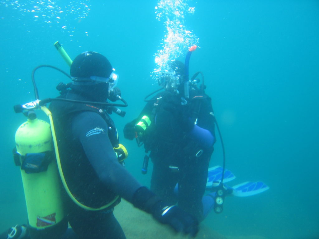
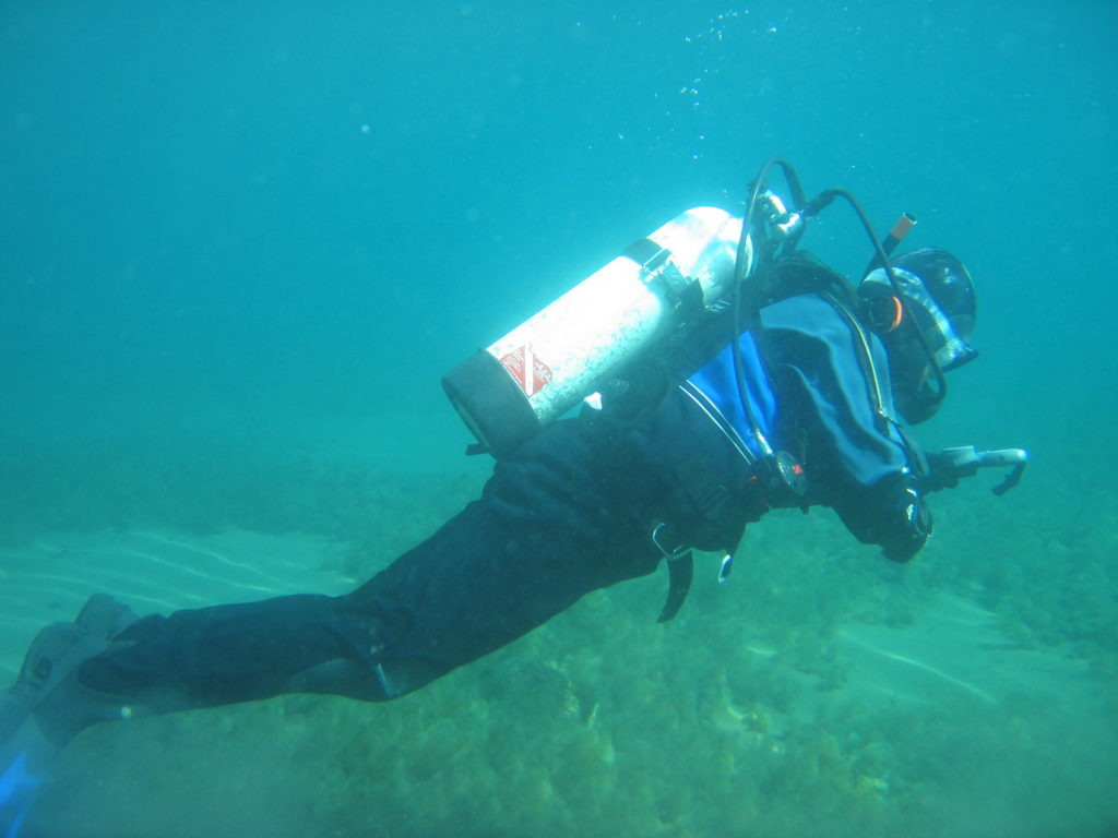
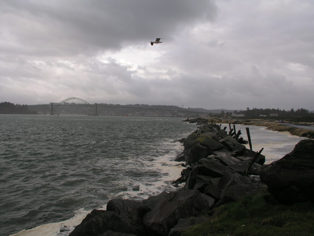
The fourth finger on the south jetty in Newport, Oregon is a great saltwater dive.  We have spent many great days diving on the Oregon coast at the fourth finger.  For SCUBA divers who enjoy a bit of a challenging entry and sometimes difficult underwater conditions, this is a good place to check out.  For divers who love searching for tiny life, you will be richly rewarded with many tiny nudibranchs, a bunch of different species of small crabs (and big ones, too!), and many different fish species.

Conditions can be rough at this dive site although conditions here are often better than at the fifth finger further down the jetty toward the ocean.  Keep an eye on the weather and marine forecasts to make sure this site is where you want to dive when you visit Newport.  In spite of some of the challenges of this site, we always love diving here and so will you!

Looking toward the Yaquina Bay Bridge and the waterfront in Newport. The fourth finger dive site is in the middle of the picture.

Site Highlights:

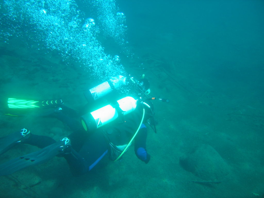
We love diving this site to look at all of the life that lives on the jetty rocks.  If you are patient, have a good dive light (we have several that we recommend), and look closely, you will find whole worlds of tiny ocean life going about their lives between the rocks.  Sea anemones grab microscopic fish and shrimp out of the water in front of your eyes.  Little hermit crabs scurry around looking for food and new homes.  Perch dart in and out of rocks, playing hide and seek with SCUBA divers.  Dungeness and red rock crabs skitter across the bottom.  This is an amazing site to dive if you’re willing to go slow and look around.

For the spearfisher or the underwater crabber, this site offers lingcod, perch, rockfish, dungeness crab, and rock crab.  We have gone spearfishing and crabbing here before with good success.

Nearest Town:

Newport is just down the jetty from the fourth finger dive site.

GPS Coordinates:

44.615504 N, -124.064237 W

Special Directions to Site:

Follow signs to the aquarium and then head west toward the ocean along Southwest Jetty Way.
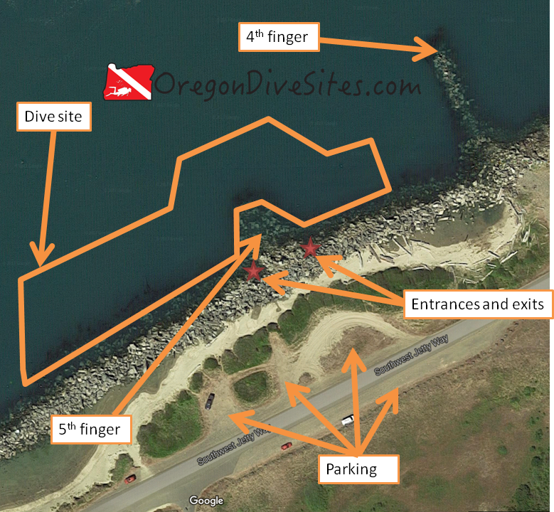
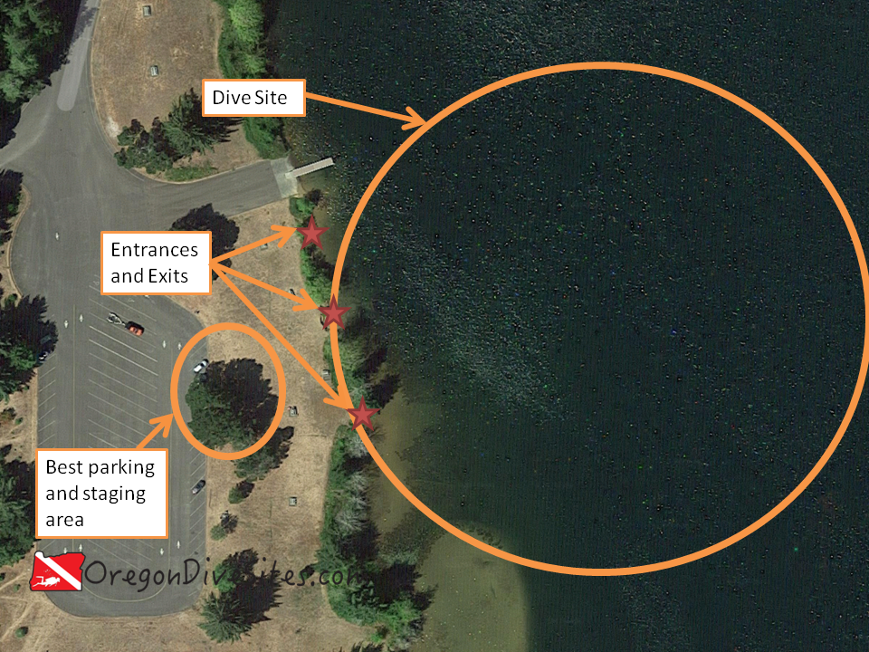
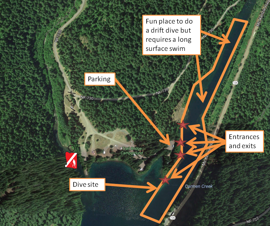
Parking:

There is plenty of parking at this dive site close to the entrance.  We like parking right by the jetty but if parking is tight, the south side of the road has more parking.

Imagery ©2017 Google, Map data ©2017.
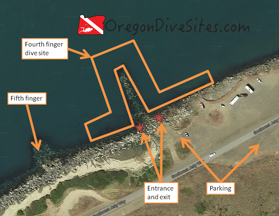
The fourth finger has ample parking. The entrance and exit are challenging but the life underwater is worth it.

Site Orientation:

The jetty runs toward the west-southwest and the ocean.  If you get separated from the jetty, head south and you’ll find it again.  If you go north, you’ll end up in the shipping channel and you will not have a good day.

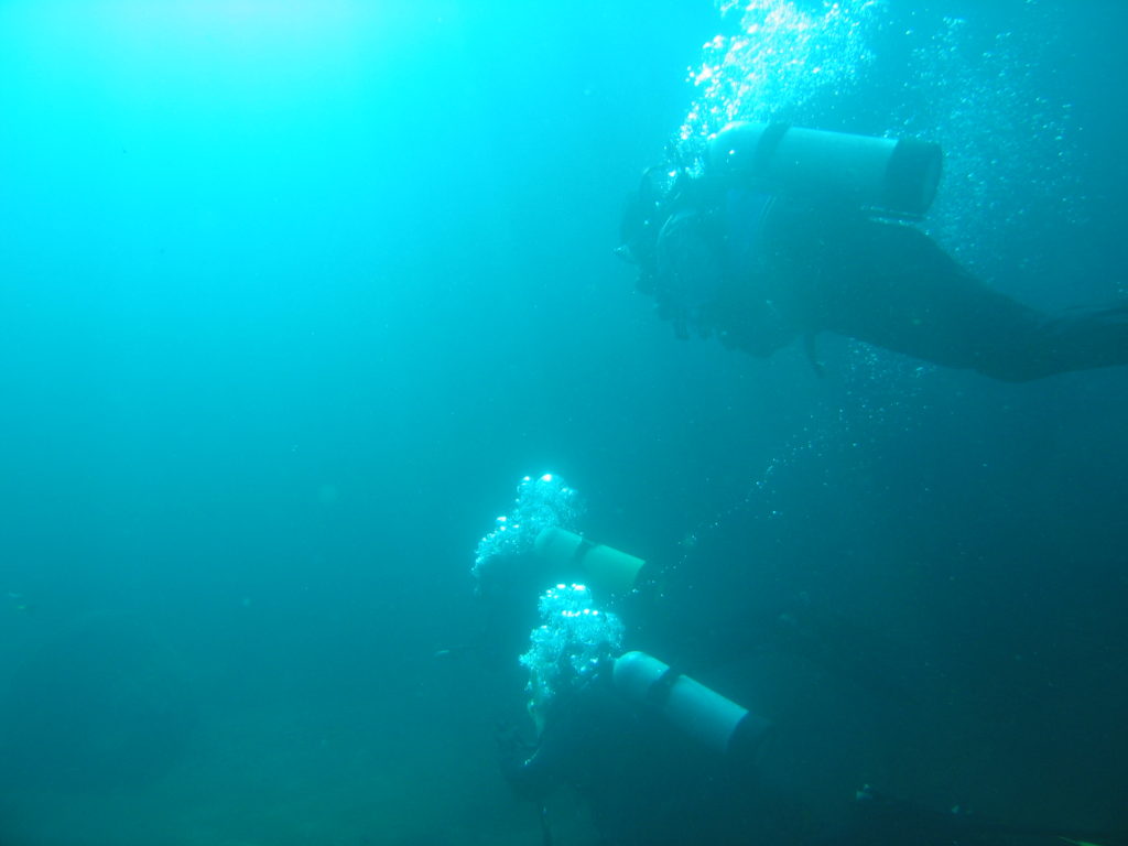
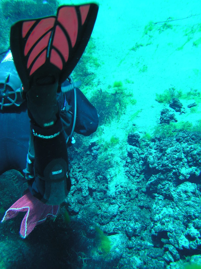
The fourth finger runs roughly north-south.  The fourth finger is about 150 feet long and can provide a whole dive of fun.  At the northern tip of the fourth finger, you will most likely run into current either moving water out of the bay or water into the bay depending on which way the tide is swinging.  On the east and west sides of the fourth finger along the jetty, the jetty rocks shelter yet more life to check out.

Entrances and Exits:

While you can climb over the jetty rocks anywhere along this dive site, the easiest entrances and exits are right at the base of the fourth finger.  Don’t get us wrong though.  This is a challenging entrance and exit because of the huge jetty rocks, the surge (and sometimes the surf), and did we mention the big jetty rocks you need to climb over?

You need to be fit, have good balance, and be nimble on your feet to do this entrance.  We have seen a SCUBA diver fall on his face here trying to cross over the jetty rocks.  Be careful, go slow, scout the entrance before you don your gear, and you should be okay.

Salt/Fresh:

This is a saltwater dive.

Shore/Boat:

This is a shore dive.

Normal Conditions:

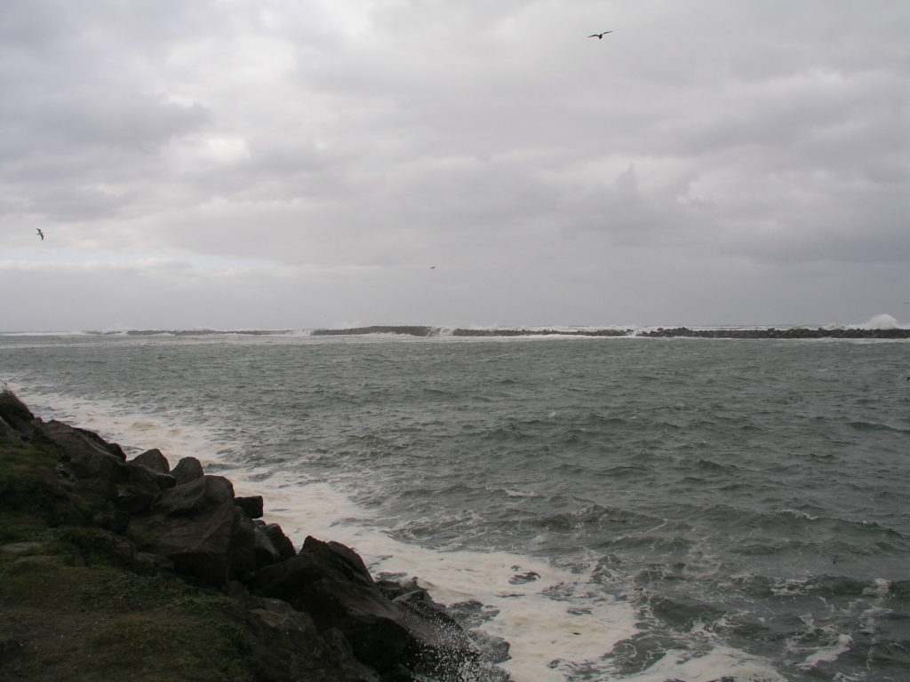
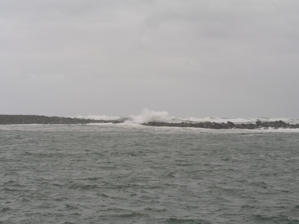
SCUBA divers can encounter a wide range of conditions here.  We once saw the water glass-smooth and we have seen breakers crash over the north jetty and make it all the way to the south jetty.  Usually divers will find some surf and surge at the entrance, and some current at the tip of the jetty.  Pay attention to the marine forecast and the weather forecast.  Only go diving here if you feel comfortable and the conditions are favorable.

Fishermen and crabbers use the fourth finger.  Be sure to watch for fishing line and crab pots.  Occasionally we have seen fishermen casting their lines directly onto SCUBA diver bubbles.  It’s a good idea to carry a good dive knife and some safety shears.  Check out our Gear We Use page for the equipment we rely on every time we go diving.

Normal Visibility:

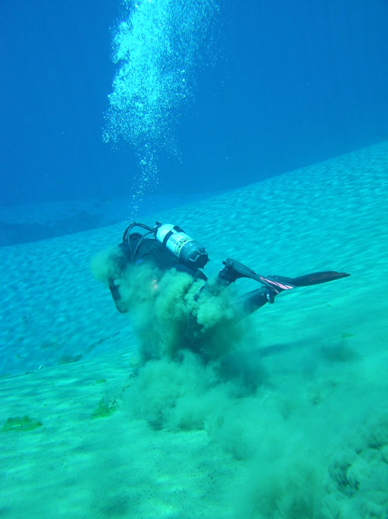
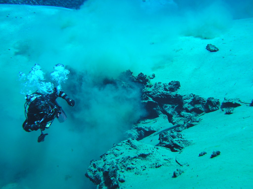
At high tide, we routinely see 15 feet of visibility at the fourth finger.  At low tide, you will be lucky to get 5 feet of visibility.  Big storms can reduce visibility.

The bottom is sand and settles quickly if stirred up.

Normal Temperature:

The temperature in the winter at this dive site can get down to about 42F.  In the summer, we have seen it up to about 50F although it varies based on ocean conditions and the tide.

Best Time of Year:

Any time of the year is good to dive here although storms in the winter reduce the number of days that you can dive the fourth finger.

Max Depth:

We have logged a maximum depth of 33 feet at this dive site at high tide.  Changing bottom conditions can make this a deeper or more shallow dive but over the years, the depth has stayed fairly constant.

South Beach State Park has great yurts that SCUBA divers can rent. The heaters in the yurts really are nice after a long day of diving around Newport.

Suggested Special Training:

We have seen just-certified open water SCUBA divers be successful at the fourth finger.  However, the entrance and exit, the surge, and the current make this a challenging site regardless of your skill level.  Be confident with your skills and be careful with your entrance and exit.

Difficulty of Dive:

The dive itself isn’t too difficult but the entrance and exit are physically strenuous.  The current at the tip of the finger can be a challenge but if you dive at slack tide, this won’t be too much of a problem.  Because of the entrance, we think this is an intermediate skill level dive.

Distance of Walk to Entrance:

Depending on how close you can park, the walk will be 50 to 100 feet.  Climbing over the jetty rocks is difficult when carrying all of your SCUBA gear.  Go slow!

Surface Swim Length:

There is no need for a surface swim here.  Get in the water, descend, and away you go!

Special Site Notes:

We strongly recommend that you dive this site at or very close to high tide.  At low tide, the visibility is not good.  While the tide is moving, the current makes it very difficult to dive this site.

In foul weather, this site can be unsafe to dive due to surf and surge.  Watch the weather and marine forecasts and only dive if you are confident that it is safe to do so.

We suggest taking a good dive knife and safety shears with you in case you get tangled in fishing line.  On our Gear We Use page, we have several knives and a shears that we use and love.

[Underwater Map of Dive Site Coming Soon!]

Closest Local Dive Shops to Get Air Fills and SCUBA Gear:

There is a dive shop in the South Beach part of Newport that can provide air fills and SCUBA gear.

Nearby Restaurants We Like:

Newport has lots of restaurants.  Tell us which ones are your favorites!

Nearby Places to Camp and Diver-Friendly Hotels:

South Beach State Park has good campgrounds.  We haven’t tried any of the hotels in town yet but there are many.

What Other People Have to Say About This Site:

Please write in the comments below your experiences with this dive site!

Categories
Central Oregon Coast

Newport South Jetty – Fifth Finger

The fifth finger of the south jetty at Newport is a great saltwater Oregon dive site for people who want a more challenging dive.  SCUBA divers are rewarded with excellent micro life all over the jetty rocks and often are treated to seeing perch, lingcod, and crabs.  Once we had a seal playfully nip at our fins here.  This dive site is physically demanding due to the entrance and divers must dive this site at slack tide (we prefer high tide for better visibility) unless they are willing to put up with a fierce current at the end of the finger.

Looking out to sea and at the north jetty from the fifth finger on a stormy day. We chose not to dive the fifth finger this day because the surge and surf were more than we wanted to deal with at the entrance.

Site Highlights:

For us, the highlight of this site is the abundant life both big and small.  We have found several species of nudibranchs, many different species of crabs including the species that you can harvest and eat for dinner, lots of different types of muscles and barnacles, many perch, rockfish, and lingcod.  People will often spear fish this dive site and will also hunt for crabs here.  We have had good luck catching red rock crabs when SCUBA diving here.  Some of our SCUBA friends like this site for the challenge of the surf and surge, and the ease of hopping between dive sites to the other four fingers along the south jetty at Newport.

If you have gone diving at this site many times, we highly recommend doing a night dive here.  The site is completely different under a full moon at high tide than what you experience during the day.

Nearest Town:

Newport, Oregon is just a few hundred feet down the jetty.

GPS Coordinates:

44.615093 N, -124.065257 W

Special Directions to Site:

Head to Newport and follow signs for the aquarium.  Take Southwest Jetty Way toward the ocean.  It can be a bit difficult if this is your first time diving on the fifth finger to figure out which of the fingers you are at.  The GPS coordinates (above) can help with making sure you’re at the right dive site.

Parking:

There are pull-outs to the north of the road.  Be sure not to block other SCUBA divers or anglers in when you park.  If you don’t mind the walk, parking across the south side of the road is also available.  Parking here was free the last time we went diving at fifth finger.

Imagery ©2017 Google, Map data ©2017 Google. The entrance and exit at this site is challenging but all of the underwater life is worth the effort.

Site Orientation:

The jetty runs west-southwest out to sea.  If you get lost, head south and you’ll find the jetty again.  If you head north, you might make it to the other jetty before your tank runs out of air but there is a good chance the current will take you up into Yaquina Bay or out into the ocean.

The fifth finger is a pile of jetty rocks that many SCUBA divers enjoy.  It only takes a few kicks to go from the jetty out to the tip of the fifth finger but there is a lot of life to see packed into the small area.  The site extends to the west along the main jetty.  We have gone along the jetty about 750 feet toward the ocean before and have found more great life but the conditions get dicey out there when the tide swings.  If you get stuck beyond the protective cover of the fifth finger, you can climb over the jetty at any point to reach dry land again.

To the east of the fifth finger is the fourth finger.  Some people like to dive the fifth and fourth fingers together.  We have done this before but we prefer diving each as a separate site so that we can take our time and enjoy looking for tiny nudibranchs smaller than a pencil eraser and scouting out the hiding holes of lingcod and crabs.

Entrances and Exits:

We won’t sugar coat the entrances and exits at the fifth finger.  They are difficult and require good physical stamina, strength, flexibility, and balance.  We have seen a few SCUBA divers fall navigating the jetty rocks trying to get into or out of the water.  Go slow and pick your route carefully.  We scout the route that we plan to take before we gear up to make sure there aren’t any surprises.

The two best places to enter and exit are on either side of the fifth finger where it meets the jetty.  You can make your entrance or exit anywhere along the jetty although other areas are more difficult.

Salt/Fresh:

This is a saltwater dive although freshwater from the Yaquina River pumps out through the estuary upstream and heads out to the ocean.  Unless you’re diving at low tide, you will have 100% saltwater.

Shore/Boat:

This is a shore dive.

Normal Conditions:

We have seen all sorts of conditions at the fifth finger from completely calm and placid days that make you think you’re diving in a swimming pool to days where the breakers are crashing over the north jetty and pounding the south jetty, too.  Pay close attention to the surf forecast and the weather report.  This is the most exposed of the five fingers.  The only more exposed you can be is if you dive the tip of the south jetty or go offshore with a boat.

When the fifth finger is good to dive, you may encounter surf, surge, and strong currents.  Anglers and crabbers use the fifth finger as well.  Be mindful of their lines and pots.  We once got tangled in a fisherman’s line when he hooked one of our fins.  Sometimes fishermen intentionally cast their hooks on top of SCUBA diver bubbles either not realizing or not caring that divers are below.  It’s a good idea to have a dive flag in the water with you.  We have one that we like and use listed on our Gear We Use page.

A big wave breaks over the north jetty. On really rough days, the waves can roll right over the north jetty and make diving the fifth finger on the south jetty all but impossible. There are plenty of other dive sites in and around Newport to dive when the fifth finger is not viable.

Normal Visibility:

Visibility is usually 10-15 feet at high tide.  At low tide, visibility can be as low as 3 feet depending on how much silt and sediment the Yaquina River is pumping out.  Recent rains and upstream logging activity can make visibility worse.

The bottom is sand and settles very quickly.

Normal Temperature:

We have seen water temperatures here between 42F and 50F depending on the time of year and ocean conditions.

Best Time of Year:

This site is fine to dive all year long although winter storms make it more challenging to find a day with good conditions.

Max Depth:

We have hit 40 feet at this dive site at high tide although most people will stay in the 30-35 foot range.

Suggested Special Training:

We know freshly certified open water divers who have successfully gone diving at this site.  However, you need to be confident in your skills, be physically fit, and dive with the conditions.

Difficulty of Dive:

The dive itself is not that difficult but the entrance and exit are hard, and the current, surf, and surge can be a challenge.  We consider this to be an intermediate dive although our SCUBA friends rate this from easy to difficult.

Distance of Walk to Entrance:

Depending on where you park, you might have to walk 200 feet.  Usually you will only need to do a 100 foot walk although the last part is over the jetty rocks.

Surface Swim Length:

No surface swim is needed here.

Special Site Notes:

We highly recommend diving this site at high tide.  We usually can get two dives in at this site back to back by diving on either shoulder of high tide.

It is a good idea to have a dive flag at this site if there are any fishermen around.  We have our trusty workhorse SCUBA flag listed on the Gear We Use page.  A dive light is also handy to look into all the hiding places on the fifth finger.

Remember to pay attention to the weather and marine forecasts.  Only dive this site if you are comfortable and know what you are doing.

[Underwater Map of Dive Site Coming Soon!]

Closest Local Dive Shops to Get Air Fills and SCUBA Gear:

There is a dive shop in Newport that does air fills and has a selection of SCUBA gear.

Nearby Restaurants We Like:

Newport has a whole host of great restaurants on both sides of the bay.  Let us know if you have suggestions on where to eat.

Nearby Places to Camp and Diver-Friendly Hotels:

South Beach State Park Campground is a good place to camp if you’re diving in Newport.

We haven’t tried any of the hotels or private campgrounds in the area.  Let us know if you have suggestions on where to stay.

What Other People Have to Say About This Site:

Please write in the comments below your experiences with this dive site!

Categories
Central Oregon Coast

Florence – Woahink Lake East Boat Ramp

The Woahink Lake east boat ramp near Florence, Oregon is a great place to go if you want to use up some air in your tanks after diving the north jetty on the Siulsaw River (either the SCUBA park or further out on the jetty), you want to rinse your gear off in fresh water, you need to test some new equipment out in a forgiving environment, or you want to work on some skills.  The site is used often by local dive shops for open water and rescue diver courses although the site is big enough to accommodate several large groups diving at the same time.  Visibility is usually 20 feet before the water gets stirred up.  The bottom has a lot of silt that is easy to stir up and reduce visibility down to 5-10 feet.  The silt settles quickly though.  The main attractions at this site are a jumble of logs off to the right of the boat ramp and a sunken kayak a few hundred feet in front of the boat ramp.

Woahink Lake East Boat Ramp Area.
There are several conveniently located picnic tables next to the parking lot where you can assemble your equipment and gear up. If you have a larger group, part of the group can stay on shore here cooking lunch or heating up water for hot chocolate while the rest of your group is diving.

Site Highlights:

The main highlights of this site are the pickup sticks pile of sunken logs on the south side of the dive site and the intentionally sunken kayak out at the eastern edge of the dive site.  There is a variety of life that you might see such as crayfish, trout, the occasional freshwater shrimp, and loads of newts and salamanders.  If you dive around the boat ramp, you might find some gear dropped overboard from boaters.

Nearest Town:

Florence, Oregon

GPS Coordinates:

43.927329 N, -124.097511 W


Special Directions to Site:

The road to the dive site is clearly signed from US101.  If you are driving south on US101 from Florence, there is a center turn lane that makes turning left across traffic easier.  If you’re driving south on US101 and you see a lake off to your left, you’ve gone too far.  If you’re driving north on US101 and you see a light commercial/industrial park on your right, you’ve gone too far.

Look for signs for the Jessie M. Honeyman Memorial State Park and Canary Road.  Once you’re heading east on Canary Road, you will cross two small bridges.  After the second small bridge, take the first right.  If you cross a third larger bridge, you’ve gone too far.  You will drive down into a parking area.  Stay to the left where the road forks.  There is car parking along the eastern side of the lot (closest to the boat ramp).  We usually park under the trees next to the picnic tables.

Parking:

In the fall, winter, and spring we have never had trouble finding ample parking on the weekends.  We have not gone diving in the summer at this site so we can’t report on how packed it gets on hot summer days.  Day use parking is $5/vehicle.

Woahink Lake East Boat Ramp Site Overview.
Imagery © 2017 Google, Map data © 2017 Google.

Site Orientation:

The dive site is roughly oriented on N-S-E-W compass bearings.  When in doubt, head west and you will find the shore.  The jumble of sunken logs is due west of the big tree circled in orange in the image above.

Entrances and Exits:

The entrances and exits that we normally use require some careful foot placement to step up and down from the bank to the small beaches at each entrance point.  For those who have trouble with the big steps, you can enter and exit at the boat ramp assuming that there is no boater traffic.  It would be worthwhile to talk with a State Parks employee to ask for permission if you are using the boat ramp as an entrance and exit.

Salt/Fresh:

This is a fresh water dive and is perfect for rinsing your gear after diving at the jetty in Florence.

Shore/Boat:

This is a shore dive although you could practice your boat diving skills here if you wanted.

Normal Conditions:

The lake is usually calm and quiet.  Boaters can add a level of complexity and you should post a dive flag .

Normal Visibility:

Usually you get 10-20 feet of visibility, depending on if it’s been raining lately and if sediment has washed in from the surrounding streams.  If you stir up the silt on the bottom, things can go down to 1-3 feet pretty quickly.  However, all you need to do is swim a little bit in any direction and you’ll be back in clearer water.  The silt settles back down to 5-10 feet of visibility after a few minutes and the visibility goes back to normal after a half hour or so.

Normal Temperature:

We have seen water temperatures here as low as 43F and as high as 52F.  Very occasionally you might experience a thermocline in the top foot or two of the water column if it has been heavily raining.  Diving in a dry suit with proper thermals or a 7mm farmer john-style wet suit is appropriate at this site.  We know a guy who used to dive here without a hood but we’d recommend full neoprene protection from the cold.

Best Time of Year:

Fall, winter, and spring are all great times of year to dive this site.  The park is quiet and you often will have the place to yourself.  If a SCUBA class is at this site, try the Woahink Lake west boat ramp or the Woahink sunken train wreck.

Max Depth:

If you really search for it, you can hit 40 feet by burying your gauge in the muck in a couple places at this dive site.  Normally you will hit between 25 and 35 feet depending on what part of the site you visit.

Suggested Special Training:

This site is appropriate for open water divers after they have completed their checkout dives and have been certified.

Difficulty of Dive:

This dive site is easy to dive.  Woahink Lake provides an excellent place for SCUBA divers of any physical ability.

Distance of Walk to Entrance:

From the parking lot to the entrance, you have about 150 to 200 feet to walk.  You descend down a gentle hill.  There is a big step down from the bank to the beach although you can use the boat ramp to enter if the step is too much for you.

Surface Swim Length:

You can wade out about 20 feet from shore to start your dive or kick out another 50 feet to descend down to about 15-20 feet deep.

Special Site Notes:

Watch for boat traffic especially in the summer.  A dive flashlight could be useful to look under logs for newts and salamanders.

[Underwater Map of Dive Site Coming Soon!]

Closest Local Dive Shops to Get Air Fills and SCUBA Gear:

There used to be a shop in Florence although we can’t confirm at this point if it is still open for business.  Please contact us if you know of any local shops for air fills and SCUBA gear!

Nearby Restaurants We Like:

The old town area of Florence has several good seafood restaurants.  Along the riverfront you can sometimes spot a group of river otters playing on the banks.

Nearby Places to Camp and Diver-Friendly Hotels:

There are several state park campgrounds near the dive site.  We have not tried any of the hotels in Florence yet.  If you know of a good place to stay, please contact us.

What Other People Have to Say About This Site:

Please write in the comments below your experiences with this dive site!

Categories
Central Cascades

Trail Bridge Reservoir – Campground Bay

The campground at Trail Bridge Reservoir is a great place to stay for a day or two while you dive the lakes and reservoirs of the Central Cascades.  The bay directly in front of the campground is an easy and simple dive where you can hone your dive skills, play around in the grass and algae beds, and hunt for golf balls that other campers have chipped into the lake.  The water can be quite warm by Oregon Cascade standards in the summer when the bay heats up in the sun.

Practicing skills underwater at Trail Bridge Reservoir.

Site Highlights:

This Trail Bridge Reservoir site doesn’t have too many interesting things to look at underwater but it is pretty fun to hunt for golf balls.  This is a good site to practice skills, try out new gear, or burn the last air in your tanks after doing dives at other sites in the area.  There are also plenty of tree stumps to check out.

Nearest Town:

This dive site is in the middle of nowhere.  The closest larger town is Eugene/Springfield.  The little town of Rainbow is down the McKenzie River Highway but is not close.  You need to be self sufficient at this Oregon dive site.

GPS Coordinates:

44.278416 N, -122.048862 W


Special Directions to Site:

Most people will drive up the McKenzie River Highway (State Highway 126) from Eugene, Oregon to reach this dive site.  The left turn onto the National Forest road can be a little tricky if there is much traffic.  Signal and brake early for the turn.

Once you’re on the forest road, follow signs for the Trail Bridge Campground.

Imagery ©2017 Google, Map data ©2017 Google. Parking and camping are plentiful at this dive site.

Parking:


There is ample parking all along this dive site.  In the summer, many of the places to park are filled with weekend campers.  The boat ramp area to the west of the dive site usually has space to park and assemble dive gear if nowhere else does.  While the parking has been free for day use when we have gone SCUBA diving at this site, that may change in the future.  Be sure to check at the information kiosk for up-to-date details.

Site Orientation:

The dive site is laid out around a large shallow bay.  If you go north, you will hit land and a close-by exit.  If you go south, you will end up in somewhat deeper water and run into the Trail Bridge Dam.  Don’t get too close to the dam’s water control system or you could end up getting sucked over, under, or through the dam which would put an early end to your SCUBA diving career.

Entrances and Exits:

There are plentiful entrances and exits all the way around the west, north, and east sides of this dive site.  You can usually park your car right next to one of the entrances.  Some of the entrances and exits do have a big step down to the water but many are gentle slopes into the water.  The boat ramp provides access for divers with limited mobility.

Salt/Fresh:

This is a fresh water dive.

Shore/Boat:

This is a shore dive although you could launch a boat into the lake and practice boat diving if you wanted.

Normal Conditions:

The water level in Trail Bridge Reservoir can change rapidly depending on what the Eugene Water and Power Board is doing with the hydroelectric projects along the McKenzie River.  Over the course of an afternoon, we have seen the water level change by seven feet.

Normal Visibility:

Visibility is usually about 20 feet in this part of the reservoir.  The bottom has a lot of silt on it that can be easily stirred up leading to near zero visibility.  It can take a while for the silt to settle back down on the bottom.

Normal Temperature:

We have seen the shallower portions of the bay reach 55F in the summer while in the spring, the deeper portions can be 40F.  Usually the lake seems to be around 45F.

One of the ubiquitous beer cans that you can find on the bottom of this dive site. If you want a good project for your scout troop, collecting all of the aluminum cans and taking them to be recycled would be a great way to spend a weekend.

Best Time of Year:

We prefer diving Trail Bridge Reservoir in the fall although the spring and summer are also good times to go SCUBA diving here.

Max Depth:

If you go way out toward the dam, you can sometimes find 50 feet of water.  Usually though you will be between 15 and 30 feet deep.

Suggested Special Training:

This lake is at 2,000 feet above sea level.  That means that you need altitude diver training to dive the lake safely.  The site otherwise can be enjoyed by anyone from a fresh open water diver to experienced divers with thousands of logged dives.

Difficulty of Dive:

This dive site is very easy and accessible.  The only difficulty is that it is an altitude dive and you need the training to dive at altitude.

Distance of Walk to Entrance:

Depending on how far away you have to park from the shore, between 10 and 100 feet of walking might be needed.  If you surface at the wrong place (this is a great place to practice navigation skills), you might have to walk farther.

Surface Swim Length:

You will want to swim 50 to 100 feet away from shore to start your dive in deeper water although if you want, you can start diving as soon as the water is waist deep.

Special Site Notes:

The water level at Trail Bridge Reservoir can change suddenly, dramatically, and without warning.  On one dive, we started the dive with the lake full and came out after the dive with the water level dropped by five feet!

Motorboats do use this lake.  It might be a good idea to have a diver down flag.  We have our favorite diver down flag listed on the Gear We Use page.

[Underwater Map of Dive Site Coming Soon!]

Closest Local Dive Shops to Get Air Fills and SCUBA Gear:

There are no nearby SCUBA shops at Trail Bridge Reservoir.  The closest shops are in Eugene and Springfield over an hour away.  You need to be self sufficient at this site.

Nearby Restaurants We Like:

There is a limited hot food service at the resort at Clear Lake up the McKenzie River Highway.  Otherwise there are a couple restaurants in Marion Forks and Rainbow.  Each little town is more than a half hour away from the dive site.

Nearby Places to Camp and Diver-Friendly Hotels:

The cabins at the resort at Clear Lake have been used by divers in the past.  Be sure to ask what to do with your dive gear and then follow what the resort staff tell you to do.  We want to be able to keep using these cabins!

All around the dive site is public camping.  Usually you can find a good site to setup your tent or park your travel trailer.  If all of the good sites are full, there is more camping at Clear Lake and Smith Reservoir.  You can also do primitive camping in the National Forest although you should check with the local ranger office for any fire restrictions or camping restrictions due to logging activity.

What Other People Have to Say About This Site:

Please write in the comments below your experiences with this dive site!

Categories
Central Cascades

Trail Bridge Reservoir – Day Use Area Sunken Creek

The day use area at Trail Bridge Reservoir near the old creek that comes down from Smith Reservoir is a fun place to practice your buoyancy skills in a forgiving environment.  While most of the dive site is sand, there are a few submerged logs, and there is plentiful green algae common to the lakes along the McKenzie River.  This is a fun spot to SCUBA dive with friends and take photos of one another.  Entrance is easy from the parking area and the boat ramp.

Practicing some neutral buoyancy skills at the south end of this dive site at Trail Bridge Reservoir.

Site Highlights:

This SCUBA diving site doesn’t have much to look at like some of the nearby dive sites do, but what it lacks in interesting underwater features, it makes up for by providing a fun and forgiving place to practice neutral buoyancy skills that divers learn in peak performance buoyancy classes.  If there is enough water flowing down from Smith Reservoir through the old creek, this can also be a little bit of a drift dive although usually the water flow is slow enough that there isn’t much current.

Nearest Town:

There aren’t any towns close to this dive site.  Eugene is over an hour away down the McKenzie River Highway.  Rainbow is the closest small town that has gas and a convenience store.

GPS Coordinates:

44.278722 N, -122.050289 W

Special Directions to Site:

Most people will come from Eugene up the McKenzie River Highway (State Highway 126).  The left turn onto the forest access road (National Forest Road 730) is a bit tricky.  Be sure to put your blinker on early and slow down with plenty of time.

Parking:

There is plentiful parking at this site.  Don’t block boat trailer parking.  Check at the information kiosk to verify that day use parking is still free.  The last time we went diving at this site, it was.

Imagery ©2017 Google, Map data ©2017 Google.
This dive site at Trail Bridge Reservoir is a good place to practice your neutral buoyancy skills.

Site Orientation:

The creek is roughly on a north-south orientation.  You can’t get lost in the creek because the channel is narrow and the current goes to the south.  Once you pass the boat ramp heading south, the channel continues on into deeper water.

Entrances and Exits:

There are several entrances and exits that are an easy walk to get into the water.  The boat ramp is the easiest entry but the others are very easy, too.

Salt/Fresh:

This is a fresh water dive.

Shore/Boat:

This is a shore dive.

Normal Conditions:

The water level in Trail Bridge Reservoir can change quite a bit throughout the day.  We’ve seen swings of up to 7 feet from morning to afternoon.  Water levels depend on what the Eugene Water and Electricity Board is doing with the hydro projects up and down the river.

Normal Visibility:

Visibility is usually 10-20 feet at this SCUBA dive site.  For Oregon, that’s pretty good.  In the spring, runoff from the area drained by the creek can decrease visibility, especially if logging is occurring upstream.

The silt on the bottom is pretty easy to stir up.  This makes for a good place to practice your buoyancy skills.

Normal Temperature:

We have seen water temperatures in the upper reaches of the creek down to 35F when the snow is melting and down near the boat ramp up to 55F during the summer.  Usually the water is about 45F.

A collection of tree limbs in the sunken creek. There are a few fallen trees that stick out into the creek as well.

Best Time of Year:

We prefer this dive site either in the spring or fall when there is enough runoff to make a little current in the creek.  The site is inaccessible in the winter due to snow.  In the summer, it can be busy by the boat ramp but is still diveable.

Max Depth:

At the extreme southern end of this dive site, you can sometimes hit 40 feet.  In the creek, you are around 10-15 feet.

Suggested Special Training:

This is an altitude dive because Trail Bridge Reservoir is at 2,000 feet above sea level.  Make sure you have altitude diver training.  Otherwise, this site can be enjoyed by just-certified open water divers up to very seasoned divers with hundreds of dives under their weight belts.

Difficulty of Dive:

The dive is very easy although those who have not practiced their buoyancy skills much will find the shallow depth to be a good challenge.

Distance of Walk to Entrance:

Depending on where you park, 20 feet up to 200 feet.  The walk is easy, level, and mostly graveled.

Surface Swim Length:

There is no surface swimming here unless you want to.

Special Site Notes:

The water level in Trail Bridge Reservoir can change rapidly and without warning.  We have seen swings of up to 7 feet in a day.  The dam beyond the southern boundary of this dive site should be avoided.  You don’t want to get sucked into the machinery and end up as finely diced SCUBA diver fish food.

Motorboats do use the lake and are launched from the boat ramp at the east side of this dive site.  A good diver flag on a reel will help you to stay safe.  We have one that we highly recommend on our Gear We Use page.

[Underwater Map of Dive Site Coming Soon!]

Closest Local Dive Shops to Get Air Fills and SCUBA Gear:

There are no close dive shops here.  The shops in Springfield and Eugene are the closest.  You must be self-sufficient to dive this site.

Nearby Restaurants We Like:

There is limited hot food service at the resort up the road at Clear Lake.  Otherwise there are restaurants in Marion Forks and Rainbow, each over 30 minutes away.

Nearby Places to Camp and Diver-Friendly Hotels:

The cabins at the resort at Clear Lake are an option.  Be sure to ask the staff what you should do with your dive gear and don’t go against their wishes.  We want SCUBA divers to still be welcomed at the cabins!

There is ample camping around Trail Bridge Reservoir.  There are additional improved campgrounds at Clear Lake up the road and up the National Forest road at Smith Reservoir.  You can also do primitive camping in the National Forest but be sure to check at the local ranger station about any seasonal restrictions or fire danger closures.

What Other People Have to Say About This Site:

Please write in the comments below your experiences with this dive site!

Categories
Central Cascades

Trail Bridge Reservoir – Submerged River

The submerged riverbed of the McKenzie River in Trail Bridge Reservoir is a fun dive outside of Eugene, Oregon.  Depending on how much water is being discharged from the Smith Reservoir hydroelectric project through the powerhouse above this dive site, the site can be dived as a drift dive.  In lower water flow times, it is easy to swim underwater up one riverbank and down the other.  There are old stumps, logging cables, other logging detritus, and trout to be seen.  Visibility is usually 20+ feet but sometimes is better depending on the time of year and how much water is flowing through the reservoir.

A group of SCUBA divers getting ready for training dives as part of an Altitude Diver specialty course at Trail Bridge Reservoir.

Site Highlights:

The main highlight of this SCUBA diving site is the submerged riverbed of the McKenzie River.  On the east bank, Sweetwater Creek pours into the reservoir from a culvert in a small waterfall that is fun to swim under.  In the riverbed, we have found old choker cables from logging operations, many beer cans, and golf balls.  Sometimes you can spot the odd trout swimming by in the gentle current.  If you’re up for the challenging surface swim, you can swim far up the old riverbed toward the hydroelectric turbines at the very head end of Trail Bridge Reservoir where water from Smith Reservoir comes down the penstocks.  From there, you can do a leisurely drift dive back to your car.

Nearest Town:

This Oregon dive site is in the middle of nowhere.  Eugene and Springfield are the two closest big towns.  The little berg of Rainbow is down the McKenzie River Highway and has a few services.

GPS Coordinates:

44.279335 N, -122.045625 W

Special Directions to Site:

Most people coming to Trail Bridge Reservoir will come up the McKenzie River Highway (State Highway 126) from Eugene, Oregon.  The turn onto National Forest Road 730 can be tricky if there is a lot of traffic.  Slow down in advance and put your turn signal on early.

Parking:

We usually park right next to the old riverbed of the McKenzie River.  Sometimes people are camped here but the area is large enough that you can find a spot to park your car, assemble your dive gear, and get into the water.  In the winter, the snow is deep enough that there is nowhere to park and this reservoir is effectively closed to diving.

Check at the information kiosk to see if you need a day use or camping permit.  The last time we went diving at Trail Bridge Reservoir, it was free, but this might change in the future.

Trail Bridge Reservoir is a good place to camp for a few days while you dive the lakes up and down the McKenzie River.

Site Orientation:

The dive site runs roughly north-northeast to south-southwest.  At the top end, you will run out of water deep enough to dive in as you approach the hydroturbines.  Don’t get too close to the turbines!  You will hear the noise from the machinery as you start to get close to them.

At the southern portion of the dive site, the river opens up into the main body of Trail Bridge Reservoir.  We don’t usually go much further than the point of land that sticks out into the reservoir.  There is not too much to see further out and the swim back can be tiring if there is very much current.

Entrances and Exits:

There are several good entrances and exits right by the parking area.  We usually walk up to the upper-most entrance to get in and come out at the lowest exit on the spit of land that sticks out into the main body of Trail Bridge Reservoir.

Most of the entrances and exits have a large step or two on somewhat tricky ground to get down to the water.  Depending on how much water is in the reservoir, there can be more steps that you have to deal with.  The southern-most entrance/exit is very gentle and only about 100 feet away from the parking area.  If you have trouble with big steps, this is the best entrance for you.

We have seen some SCUBA divers get in further north along the old river channel but the entrances are very difficult with steep rocky descents down to the water.  If you want to do one of the entrances further up the old riverbed, scout it out ahead of time to determine if it’s something that you want to tackle.

Be courteous of other people who might be camped at or enjoying an afternoon at the lake.  Don’t walk through where they are having fun without asking permission.

Visibility is often 20 feet or better in Trail Bridge Reservoir. There are lots of little nooks and crannies along the submerged riverbed to explore.

Salt/Fresh:

This is a freshwater dive.

Shore/Boat:

This is a shore dive.  You could take a small inflatable zodiac up the channel to do the whole drift dive.  There is an area to launch boats further to the west in the lake.

Normal Conditions:

There is normally a gentle current in the lower stretch of this dive site.  In the upper end, the current can be a little more swift.  Depending on what the Eugene Water and Electric Board is doing with its many dams along the river, the lake level can rapidly rise or fall.  This can lead to big changes in the current.  At the top end of the dive site, the hydroelectric turbines make a lot of noise underwater.  Don’t get too close to the turbines.  Below the bottom of the dive site, there are dam works that you should steer clear of.  You don’t want to get sucked over, under, or through Trail Bridge Dam.

Normal Visibility:

Visibility is usually around 20 feet in the old river channel.  Because of the current, any stirred up silt will quickly be pushed away.

Normal Temperature:

We have seen water temperatures ranging from 40F to 52F depending on the time of year and how much water is flowing through the reservoir.  Early in the spring during the spring snow melt, water temperatures can be colder.  Occasionally, we have encountered a thermocline in the top few feet of the water column near the Sweetwater Creek waterfall on the east side of the dive site.  Very rarely, we’ve encountered some chilly water in the very bottom of the river bed.

Best Time of Year:

We prefer diving this site in the summer and fall.  The site can be dived in the spring after the snow has melted from the parking area although the water is colder then.  In the winter, the site is inaccessible because of the snow.

Max Depth:

If you take a shovel and start digging, you can hit 40 feet.  Most of the site is in the 25-30 foot range.  The farther upriver you go, the shallower it gets.

Suggested Special Training:

Open water divers with several dives under their belts will find this site accessible to them.  However, this is an altitude dive and you should have an altitude diver specialty course certification.  The reservoir is at 2,000 feet above sea level.  A drift diver specialty course is also useful if you are planning to do a drift dive.

Difficulty of Dive:

The diving is easy in the lower portion of the dive site.  In the upper portion, the dive can get more strenuous because of the current.  We rate this an intermediate skill level dive site because of the altitude.

Distance of Walk to Entrance:

Depending on which entrance you use, the walk is between 20 and 300 feet.  Some of the entrances have big steps on loose ground to get to the water while one of the entrances is a very mild walk into the water.

Surface Swim Length:

You can start diving right from the entrances or you can do a surface swim upriver to do a drift dive.  A surface swim of 1000 or more feet is possible here if you want to swim that far.

Special Site Notes:

The water level can change rapidly at this site due to what the Eugene Water and Electric Board is doing with the dams up and down the river.  We have observed people hitting golf balls into the reservoir aiming for SCUBA diver bubbles although usually it is friends of the divers doing the golfing.  This site is inaccessible in the winter.  Be mindful of not going too close to Trail Bridge Dam or of the hydroturbines upstream.

Remember that this is an altitude dive and you need to be trained on how to dive at altitude.

A good dive light will help you to see into the little nooks and crannies along the submerged riverbed.  We have several dive lights we recommend and use every time we dive in Oregon on our SCUBA Gear We Use page.

[Underwater Map of Dive Site Coming Soon!]

Closest Local Dive Shops to Get Air Fills and SCUBA Gear:

You’re a long way from any dive shops.  Eugene is the closest town with a shop for air fills or gear repairs.

Nearby Restaurants We Like:

Up at Clear Lake there is limited food service at the resort lodge.  Otherwise down toward the little town of Rainbow there are a few restaurants and convenience stores.

Nearby Places to Camp and Diver-Friendly Hotels:

There is plentiful camping at Trail Bridge Reservoir right at the dive site.  Up at Smith Reservoir and at Clear Lake there are additional camping grounds.  Clear Lake has resort cabins that can be rented.  The National Forest generally allows primitive camping but check with the local ranger station for current restrictions due to logging or fire danger.

What Other People Have to Say About This Site:

Please write in the comments below your experiences with this dive site!

Categories
Central Cascades

Clear Lake – Main Pool Sunken Forest

The main pool of Clear Lake has a huge sunken forest in the bottom of it.  Visibility of 100+ feet means that you can see the surface when you’re at a max depth of 100 feet in some of the deep underwater spring holes at the bottom of the lake.  A short surface swim is needed to reach the sunken forest.  You don’t have to worry about motorized boat traffic on Clear Lake because all engines are banned on the lake.


Clear Lake’s main pool from the shallows at the entrance.

Site Highlights:

The three big draws at the main pool on Clear Lake are the visibility (100+ feet of viz!), the sunken forest (80 foot tall tree trunks submerged underwater by a lava flow damming up the river!), and the huge potholes in the bottom of the lake where clear, cold spring water flows up from the basalt rocks underneath.  Sometimes you will also see a few trout and some freshwater shrimp at this site.  The craziest thing at this site by far is looking up when you’re 100 feet underwater and seeing the surface.  A lot of people will tell you that diving in Oregon is no fun because you can never see more than 20 feet but we’re here to tell you that at Clear Lake, you can see at least 100 feet when you’re underwater.

Nearest Town:

Clear Lake is in the middle of nowhere.  The closest towns of any size are Eugene/Springfield, Albany, Bend, and Salem.  Smaller Oregon hamlets like Rainbow, Marion Forks, and Sisters have basic services like gasoline and convenience stores or restaurants but they are all a long drive away.

GPS Coordinates:

44.371117 N, -121.995891 W

Special Directions to Site:

If you are coming from Salem or North, you will take the North Santiam Highway (State Highway 22) from Salem toward Bend.  At Santiam Junction, follow the signs for Eugene onto US 20 West and then onto State Highway 126.  If you are coming from Albany or Corvallis, US 20 East to Santiam Junction is the fastest way to go.  Then follow signs for Eugene down State Highway 126 (McKenzie River Highway).  Coming from Eugene and the south, take State Highway 126 out of Springfield up the McKenzie River.  If you’re coming from Bend, follow US 20 East to Santiam Junction.

Once you’re near the lake, you will see signs for the Clear Lake Resort.  You will turn onto National Forest Road 775 (paved).  Note that this is a one-way road!  It is well signed.  Then follow the road down until you are near the lodge and you find paved parking.

Parking:

In the fall, winter, and spring, there is usually ample parking at this site in free day-use parking spots to the south of the lodge at the resort.  In the summer, it can become very difficult to find parking here.

Day use parking is free but fills up fast in the summer. Winter is a good time to dive to beat the crowds at Clear Lake.

Site Orientation:

This site can get a little complex once you’re underwater because of how big it is.  Generally, you want to go north and west to find your way back to the exit.  When you enter the water, you want to head east and south to find the potholes and the sunken forest.  If you go too far south, you will end up at the other end of the lake and have either a very long surface swim, or a very uncomfortable hike back to your car.

Entrances and Exits:

The best place to enter and exit is to the south of the day use parking area.  There is a small path through the forest for about 200 feet to get to the entrance.  The entrance is easy to walk into although at times there can be a submerged log or two to stub your toe on.  Most people shouldn’t have any trouble with this entrance and exit.

Salt/Fresh:

This is a freshwater dive.

Shore/Boat:

This is a shore dive although you can put in non-motorized boats on the lake.  A boat could be useful if you want to more directly access the underwater forest without as much of a surface swim.

Checking out a cold freshwater spring in a deep pothole in Clear Lake. Be aware that when you go into these potholes, your chance of a frozen or free flowing regulator increase because of the depth (increased air consumption) and the temperature (ice cold water out of the springs).

Normal Conditions:

This lake is usually a pretty calm place.   There is more boat traffic in the summer although none of it is motorized.  Lots of anglers come to fish the lake so watch out for lures and line.

Normal Visibility:

Visibility here is usually 100+ feet.  It’s not unheard of to find 200+ feet of visibility in the fall before the winter rain and snow starts.  If you stir up the bottom, in most the lake the water will clear pretty quickly.  However, you should try to maintain good neutral buoyancy control to not spoil the viz for anyone else diving or people who are swimming or boating.

Normal Temperature:

We have seen it as high as 42F and as low as 31F at this lake.  Sometimes a very cold layer of water (thermocline) can be in the top few feet of the water column.  The water coming out of the springs in the potholes at the bottom of the lake can be 31F at the right time of year.  This makes it much more likely that your regulator will freeze up or free flow at depth.  We had one of our first stage regulators freeze and free flow at 100 feet in a pothole and had to abort the dive.  We know some people who have gone diving at Clear Lake with a wetsuit but we sure are happy to have drysuits for this dive.

Best Time of Year:

Fall, winter, and spring are the best for beating the crowds.  Fall has the best visibility but the viz is never bad here.

Max Depth:

You can go deep in the main pool at Clear Lake.  We have hit 100 feet in some of the deep holes and could have gone deeper if we wanted.  Remember that this is an altitude dive so your bottom time changes compared to sea level.  When you are at depth with this cold of water, you can have your regulators freeze and free flow.  It happened to us once here.  If you are in doubt about your gear, get a qualified professional at your local dive shop to examine your gear and tell you what conditions are safe for your gear to operate in.  Even with good gear meant for cold water, freezes and free flows are still possible.

Deep, clear water awaits SCUBA divers at Clear Lake! A whole underwater forest is down there, just waiting to be explored.

Suggested Special Training:

Advanced open water training is a must for this site.  It is big, deep, and cold.  A deep diver specialty class will also be useful here.  Altitude diver training is necessary so that you can dive this site safely.  it is over 3,000 feet above sea level at the lake.

Difficulty of Dive:

The entrance and exit are easy, the current is very mild, the visibility is excellent, but this can be a challenging dive because of the cold and the depth.  You need to be confident in your emergency ascent abilities.  You also need to be able to deal with the cold water.

Distance of Walk to Entrance:

The gentle path through the forest is about 200 feet from the day use parking area down to Clear Lake.  If you have to park in one of the further away parking areas, it will increase your walk a bit.

Surface Swim Length:

You can start diving right away from the entrance.  We suggest kicking out into the lake 500 to 1000 feet from shore heading due east before you start your dive.  This will give you maximum bottom time at all of the interesting stuff (the underwater forest, and the potholes and springs).  For those who don’t mind a long surface swim, going all the way to the east shore and starting your dive from there will maximize what you see with a tank of air.

Special Site Notes:

Remember that this is a deep, cold dive.  Regulator freezes and free flows do happen.  It happened to us once here.  Be prepared to abort your dive and immediately ascend to the surface if you have a free flow.

This is an altitude dive and can be a deep dive — both require special training.

It’s a good idea to take a flashlight to check out the deep fissures in the bottom of some of the potholes where the underwater springs are.  We have our favorite lights listed on our Gear We Use page.

[Underwater Map of Dive Site Coming Soon!]

Closest Local Dive Shops to Get Air Fills and SCUBA Gear:

There are no close dive shops to Clear Lake.  You will need to go to Eugene, Salem, or Bend to get any gear serviced or tanks filled.  You need to be self sufficient at this dive site.

Nearby Restaurants We Like:

The lodge at the resort on Clear Lake has limited hot food options and good hot chocolate.  Otherwise the closest restaurants you will find are down the McKenzie River toward the town of Rainbow or down the North Santiam Highway at Marion Forks.  If you want to go over the pass, Sisters has some good restaurants.

Nearby Places to Camp and Diver-Friendly Hotels:

The resort on Clear Lake rents out cabins.  Call ahead and ask about renting a cabin for SCUBA diving.  Don’t be “that guy” and bring your wet, smelly gear inside the cabin if they tell you not to.

There are a couple national forest campgrounds around the lake.  You can also camp in the national forest down some of the forest access roads.  Check at the local district ranger office about specifics for primitive camping.  Sometimes there are restrictions due to logging operations or fire danger.

What Other People Have to Say About This Site:

Please write in the comments below your experiences with this dive site!

Categories
Central Cascades

Clear Lake – Pool North of Lodge Boat Ramp

The Clear Lake north pool is a quintessential Oregon dive site. SCUBA divers have enjoyed the 100+ feet of visibility, easy walk-in shore diving, quiet non-motorized lake. The highlights of the lake are a sunken and flooded forest still standing after hundreds of years and a series of underwater springs pushing out thousands of gallons of water of cold, clear water every minute. The McKenzie River starts at Clear Lake and flows all the way down to Eugene where it meets the Willamette. This is a great day trip dive from Portland or the Willamette Valley.

The north pool of Clear Lake as seen from the south shore near the lodge and cabins.


Site Highlights:

People come to dive clear lake for the amazing visibility.  100+ feet is common and at the right time of year (usually fall before the winter storms start), visibility can hit 200+ feet.  The north pool is shallower than the southern part of the lake, making it more friendly to divers who don’t want to prepare for frozen or free-flowing regulators.  There are a few sunken trees from the ghost forest at the bottom of Clear Lake but the main underwater attraction (aside from the viz!) is the big potholes in the bottom of the lake where huge springs come out underwater.  The spring water is usually very cold although during heavy snow melt conditions, the surface layer of water can be colder.  The small lodge at the southern end of this dive site usually has good hot chocolate and warm food available.

Nearest Town:

Clear Lake is in the middle of nowhere.  Eugene, Bend, and Salem, Oregon are the closest major towns.  Make sure that your gas tank is topped up and you have everything you need for a day of diving before you head to Clear Lake.

GPS Coordinates:

44.375479 N, -121.998950 W

Special Directions to Site:

Coming from Eugene, the McKenzie River Highway (State Highway 126) is the most direct route.  Coming from Portland, the North Santiam Highway (State Highway 20) is fastest.  At Santiam Junction, follow the signs for Eugene onto (briefly) US 20 West and then State Highway 126.  From Corvallis, US 20 East (South Santiam Highway) to State Highway 126 is the fastest.  From Bend, take US 20 East and follow signs for Eugene onto State Highway 126.

Follow signs for Clear Lake Resort and National Forest Road 775.  The road is one-way.  You must enter from the southern end of the road.  There are signs clearly visible from the highway pointing the way.  You will be turning to the east to get onto the access road.

Parking:

Day use parking is limited at the site.  As of writing this, day use parking is free.  However, parking is limited.  In the fall, winter, and spring, we have never had a problem finding parking on the weekends but in the summer, parking is a challenge even on weekdays.  Be sure to follow posted signs.  Some parking is restricted to overnight guests of the lodge.

Imagery © 2017 Google, Map data © 2017 Google.
Clear Lake North Pool Site Overview. Note that the access road to the lake is one-way. The northern end of the access road (lower right in above image) a one-way exit. The southern end of the road (1/8 mile further south, not shown) is the entrance.


Site Orientation:

The site is not too big to get lost in and with superb visibility, it’s easy to orient yourself underwater.  The boat dock is an easily recognizable landmark to show you where the southern boundary of the dive site is located.  If you go further south, you’ll end up in the much larger main pool of Clear Lake and will encounter the huge sunken forest.

Entrances and Exits:

The main entrance and exit that divers use on this side of Clear Lake is south of the lodge and docks.  There is a short walk down a path from the day use parking area to the entrance.  The entrance is easy and straight forward.  However, entering here will give you a long surface swim fighting the current to get past the docks.

Depending on the time of year, the people in the lodge can give you permission to enter and exit at the boat ramp.  Ask nicely and they probably will say yes.  In the summer when there is a lot of (non-motorized!) boat traffic, they probably will not let you enter or exit on the boat ramp.  There are a few other more difficult to find options to enter and exit to the west of the boat ramp along the north shore pool although you have to walk by the cabins to get there.  The people at the lodge generally frown on people cutting through the cabins to get access to the lake.

Salt/Fresh:

This is a fresh water dive.

Shore/Boat:

This is a shore dive.  You could use a non-motorized boat in the north pool but there isn’t much point.  It makes more sense to use a boat in the main pool.

Normal Conditions:

Conditions at Clear Lake are usually very good, aside from the cold water.  There is a current by the boat docks that will slowly push you down into the main pool.  The springs at the bottom of the lake push out enough water to make a gentle current near them.

Normal Visibility:

Visibility is usually 100+ feet and can sometimes be 200+ feet.  While there is sand and silt on the bottom, the current quickly takes it away and anything remaining quickly settles.  The photo below shows what it looks like when you crash into the bottom because you were paying more attention to your camera than your buoyancy.

The silt and sand on the bottom of Clear Lake can reduce visibility but not enough to cause a major problem. Maintaining good buoyancy is a good idea though!

Normal Temperature:

We have seen it as high as 40F at the surface after the water has been warmed by the sun and as low as 32F in the potholes were the springs are located.  We have gone diving at this site with several feet of snow on the ground and in the hot sun.  The water temperature is always COLD!  Be aware of how your dive gear performs in very cold water.  Some regulators can free flow or otherwise freeze due to the cold.  We had this happen to us once in the main pool of Clear Lake.

Best Time of Year:

Fall, winter, and spring are the best because there aren’t any crowds and you won’t overheat in your drysuit or wetsuit while you get geared up to go diving.

Max Depth:

In the bottom of the potholes where the springs are, you can hit 90 feet.  The rest of the bottom averages between 45 and 65 feet.  REMEMBER this is an altitude dive!  You need special training to dive at altitude!

Suggested Special Training:

If you want to venture into the potholes, you should have advanced open water or deep diver training.  You should have altitude diving training as well.  The dive site is at 3,000 feet above sea level.

Difficulty of Dive:

This is an intermediate level dive because of the potential for your regulator to freeze, the cold water, and the potential max depth.  Open water divers should only dive this site if they have sufficient dives under their weight belts and feel comfortable in alpine lakes.

Distance of Walk to Entrance:

Depending on where you park and which entrance you choose, you may be walking 1000 feet on pavement with your gear or a mix of pavement and forest path.  While there are slopes, they are gentle.

Surface Swim Length:

If the boat ramp is not available for SCUBA divers, you may have to do a lengthy surface swim (1000 feet) fighting the current past the boat docks.  If you can use the boat ramp, you can start diving right away.

There are some sunken standing trees in the north pool at Clear Lake. These trees were alive when the lake was formed. They got flooded out, died, and have remained standing ever since.

Special Site Notes:

Non-motorized boat traffic is more common in the summer on Clear Lake although we have seen a boat on the lake even in the winter.  Many people fish at Clear Lake (including fly fishing) so watch out for lures and fishing line, and steer clear of areas people are fishing.

There is some current coming out of the springs and by the lodge docks.  You can swim against the current but be aware that you can get tired out from fighting the current for too long.

Be sure to ask at the lodge before you use the boat ramp as an entrance or exit.

We found flashlights to be useful to peer deep into the springs.  Check out our SCUBA Gear We Use page for the gear that we rely on for diving in Oregon.

Remember that this is an altitude dive and that with such cold water, your regulator can freeze.  We had the first stage on one of our regulators freeze and free-flow at depth at Clear Lake once which required us to abort the dive and take the regulator in for servicing.  You should be comfortable with ascending from depth with no air in case your regulator freezes and free flows!

[Underwater Map of Dive Site Coming Soon!]

Closest Local Dive Shops to Get Air Fills and SCUBA Gear:

There aren’t any close local dive shops to Clear Lake.  Bend, Eugene, and Salem are the closest towns with dive shops.  You need to be self-sufficient at this dive site.

The current coming out of the spring in the bottom of one of the potholes can make it difficult to maintain good neutral buoyancy.

Nearby Restaurants We Like:

The lodge has some limited food options.  Otherwise, you have to drive a long ways to find a restaurant.

Nearby Places to Camp and Diver-Friendly Hotels:

The lodge at Clear Lake rents cabins that some of our SCUBA friends have stayed at and gone diving from.  Be sure to ask when you reserve a cabin what the rules are on dive gear.

There are several public campgrounds around or near the lake run by the Willamette National Forest.  There are also many forest roads in the area where you may be able to camp for free.   Be sure to check local forest regulations before attempting to camp outside of a campground.

What Other People Have to Say About This Site:

Please write in the comments below your experiences with this dive site!